|
|
 Meow|2016-12-21 17:00
|
顯示全部樓層
已命名Yvette。

IDW27600
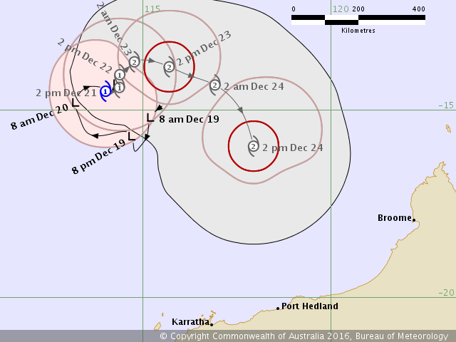
TROPICAL CYCLONE TECHNICAL BULLETIN: AUSTRALIA - WESTERN REGION
Issued by PERTH TROPICAL CYCLONE WARNING CENTRE
at: 0657 UTC 21/12/2016
Name: Tropical Cyclone Yvette
Identifier: 07U
Data At: 0600 UTC
Latitude: 14.5S
Longitude: 114.0E
Location Accuracy: within 30 nm [55 km]
Movement Towards: Slow moving
Speed of Movement: Slow moving
Maximum 10-Minute Wind: 40 knots [75 km/h]
Maximum 3-Second Wind Gust: 55 knots [100 km/h]
Central Pressure: 987 hPa
Radius of 34-knot winds NE quadrant: 60 nm [110 km]
Radius of 34-knot winds SE quadrant: 90 nm [165 km]
Radius of 34-knot winds SW quadrant: 90 nm [165 km]
Radius of 34-knot winds NW quadrant: 90 nm [165 km]
Radius of 48-knot winds NE quadrant:
Radius of 48-knot winds SE quadrant:
Radius of 48-knot winds SW quadrant:
Radius of 48-knot winds NW quadrant:
Radius of 64-knot winds:
Radius of Maximum Winds: 20 nm [35 km]
Dvorak Intensity Code: T3.0/3.0/D0.5/24HRS STT:S0.0/06HRS
Pressure of outermost isobar: 1000 hPa
Radius of outermost closed isobar: 210 nm [390 km]
FORECAST DATA
Date/Time : Location : Loc. Accuracy: Max Wind : Central Pressure
[UTC] : degrees : nm [km]: knots[km/h]: hPa
+06: 21/1200: 14.5S 114.2E: 040 [080]: 040 [075]: 988
+12: 21/1800: 14.4S 114.4E: 055 [100]: 045 [085]: 985
+18: 22/0000: 14.2S 114.3E: 065 [125]: 045 [085]: 985
+24: 22/0600: 14.1S 114.4E: 080 [145]: 045 [085]: 985
+36: 22/1800: 13.7S 114.8E: 100 [180]: 050 [095]: 982
+48: 23/0600: 13.9S 115.7E: 120 [220]: 050 [095]: 983
+60: 23/1800: 14.3S 116.9E: 140 [255]: 055 [100]: 980
+72: 24/0600: 16.0S 117.9E: 155 [290]: 060 [110]: 977
+96: 25/0600: 18.8S 120.0E: 200 [370]: 060 [110]: 975
+120: 26/0600: 21.6S 122.8E: 290 [535]: 025 [045]: 999
REMARKS:
Tropical Cyclone Yvette has developed to the north of Western Australia.
The system was located using an ASCAT pass at 0133 UTC and the latest visible
imagery.
Deep convection developed overnight and persisted during the morning and early
afternoon to the northwest and southwest of the centre.
Using a shear pattern DTs of 3.0 were obtained with the centre <0.5 from edge.
MET was 3.0 with a recent D trend. PAT was 3.0. FT/CI set to 3.0 with intensity
set to 40 knots.
CIMSS ADT had a CI of 3.5 at 0500 UTC. NESDIS ADT was 3.1 at 0400 UTC.
The ASCAT pass at 0133 UTC showed gales wrapping around the centre in the
southwest and northwest quadrants with no information in the other quadrants.
Recent motion continues to be slow.
Shear analysis at 00 UTC showed strong shear from the ENE [-30 knots], there is
upper level divergence over southern quadrants only and wind fields show little
outflow in northern quadrants. Shear may decrease later on Wednesday or on
Thursday, allowing conditions to become more favourable for development. SSTs
are around 29C with 29C to 31C along the forecast track.
The system is expected to be slow moving before tracking towards the southeast
from Friday and approaching the Pilbara/West Kimberley coast over the Christmas
weekend. There is considerable model variation on the movement and intensity of
the system, particularly in the longer term. The movement of a tropical low over
the Kimberley, then through central parts of WA may influence the development
and track of 07U.
Copyright Commonwealth of Australia
==
The next bulletin for this system will be issued by: 21/1330 UTC by Perth TCWC.
澳洲不用西北澳,因為有個州就叫西澳。 |
|