開啟輔助訪問
 找回密碼
 立即加入

01C.Walaka 中太時隔32個月迎土產氣旋 猛烈爆發成為C5

簽到天數: 601 天

[LV.9]以壇為家II

2018-9-27 23:32 | 顯示全部樓層
本帖最後由 霧峰追風者 於 2018-10-6 12:04 編輯

  五級颶風  
編號:01 C
名稱:Walaka

  基本資料  
擾動編號日期:2018 09 27 23
命名日期  :2018 09 30 05
撤編日期  :2018 10 00 00
登陸地點  :暫無

  巔峰時期資料  
近中心最強風速 :140 kt
海平面最低氣壓 :920 百帕

  過去路徑圖  

  擾動編號資料  

97C.INVEST.25kts-1008mb-12.3N-145.4W

20180927.1500.himawari-8.ir.97C.INVEST.25kts.1008mb.12.3N.145.4W.100pc.jpg
CPHC : 30%
1. Showers and thunderstorms associated with a surface trough located
about 990 miles southeast of Hilo, Hawaii are becoming slightly
more organized, but continue to flare up and down in coverage and
intensity. A low-level circulation center is now apparent on visible
satellite imagery. Environmental conditions remain conducive for
gradual development of this system over the next few days as it
moves westward across the central Pacific.
* Formation chance through 48 hours...low...30 percent.
* Formation chance through 5 days...high...70 percent.

two_cpac_2d1.png

以上資料來自:CPHC、颱風論壇整理製作

評分

參與人數 1水氣能量 +15 +1 收起 理由
t02436 + 15 + 1

查看全部評分

回復

使用道具 舉報

簽到天數: 582 天

[LV.9]以壇為家II

蜜露|2018-10-5 22:28 | 顯示全部樓層
本帖最後由 蜜露 於 2018-10-6 12:39 編輯


瓦拉卡颶風巔峰照


20181001.1900.goes-15.ir.01C.WALAKA.125kts.935mb.12.6N.168.9W.100pc.jpg


20181001.1830.goes-15.ircolor.01C.WALAKA.125kts.935mb.12.6N.168.9W.100pc.jpg


20181002.0031.goes-15.ir.01C.WALAKA.140kts.920mb.12.9N.169.6W.100pc.jpg


20181002.0131.goes-15.ircolor.01C.WALAKA.140kts.920mb.12.9N.169.6W.100pc.jpg


20181002.0131.goes15.x.wv1km.01CWALAKA.140kts-920mb-129N-1696W.91pc.jpg


回復

使用道具 舉報

簽到天數: 3279 天

[LV.Master]伴壇終老

t02436|2018-10-3 01:22 | 顯示全部樓層
開始轉北進行,15Z略微減弱到135節。
WTPA41 PHFO 021518
TCDCP1

Hurricane Walaka Discussion Number  12
NWS Central Pacific Hurricane Center Honolulu HI   CP012018
500 AM HST Tue Oct 02 2018

The satellite presentation of Walaka which was being degraded by an
eye wall replacement cycle overnight, has just begun to improve with
a ring of deep convection beginning to once again encircle the
well defined eye, which could be a sign that the eyewall replacement
cycle is getting ready to complete. The latest intensity estimates
from PHFO, SAB, JTWC were 6.5 (127 knots) while the ADT held at 6.6
(130 knots). Based on constraints likely holding the intensity of
Walaka too low Monday afternoon, have only reduced the initial
intensity slightly with this advisory to 135 knots. The initial
motion was set at 350/09 knots.

A deep north Pacific upper level low in the vicinity of 30N 170W
will draw Walaka northward over the next several days, before
another sharp upper trough shifting across the north Pacific picks
the tropical cyclone up and shifts it off to the northeast Friday
night and Saturday. Overall the guidance envelope remains fairly
tightly clustered through the forecast period. The official forecast
remains very close to that of the previous advisory and is fairly
well aligned with the latest GFEX, TVCN, HCCA consensus guidance.

The environment surrounding Walaka remains conducive for additional
intensification during the next 24 hours. The tropical cyclone will
remain within a deep moist airmass with low vertical wind shear,
high ocean heat content and sea surface temperatures between 84 to
86 Fahrenheit. Eyewall replacement cycles could lead to some
fluctuations in intensity through this time frame, so the intensity
forecast shows little intensity change through 24 hours. Beyond 24
hours, the combination of increasing vertical wind shear, drier
mid-level air entraining into the cyclone, sea surface temperatures
becoming marginal and even unfavorable, along with interaction with
the deep upper level low should result in steady and even rapid
weakening of Walaka. As a result, the intensity forecast calls for
Walaka to begin weakening on Wednesday, with rapid weakening then
continuing through the end of the forecast period. The official
intensity forecast was adjusted downward slightly, but remains above
all guidance through 36 hours before trending closer to a blend of
the statistical and dynamical models thereafter. Walaka is expected
to become an post-tropical/extra-tropical low by 120 hours.

The forecast track will take Walaka near Johnston Island later
today, with hurricane conditions expected this afternoon and this
evening. Therefore a Hurricane Warning remains in effect for this
location. The forecast track also takes the hurricane across the
Papahanaumokuakea Marine National Monument between French Frigate
Shoals and Laysan Island late Wednesday. Therefore, a Hurricane
Watch remains in effect for the region from Nihoa to Maro Reef.


FORECAST POSITIONS AND MAX WINDS

INIT  02/1500Z 14.7N 170.0W  135 KT 155 MPH
12H  03/0000Z 16.2N 170.2W  135 KT 155 MPH
24H  03/1200Z 18.9N 169.7W  135 KT 155 MPH
36H  04/0000Z 22.3N 168.4W  120 KT 140 MPH
48H  04/1200Z 26.2N 167.4W  100 KT 115 MPH
72H  05/1200Z 30.5N 168.0W   75 KT  85 MPH
96H  06/1200Z 33.0N 164.0W   60 KT  70 MPH
120H  07/1200Z 41.0N 157.5W   50 KT  60 MPH...POST-TROP/EXTRATROP

$$
Forecaster Jelsema

CP012018_5day_cone_no_line_12.png

rbtop-animated.gif

20181002.1522.f16.91pct91h91v.01C.WALAKA.135kts.927mb.14.2N.170W.100pc.jpg
回復

使用道具 舉報

簽到天數: 601 天

[LV.9]以壇為家II

霧峰追風者|2018-10-2 10:58 | 顯示全部樓層
CPHC 稍早強度升五級颶風,逐漸轉向北上。
WTPA41 PHFO 020248
TCDCP1

Hurricane Walaka Discussion Number  10
NWS Central Pacific Hurricane Center Honolulu HI   CP012018
500 PM HST Mon Oct 01 2018

Recent infrared images showed that cloud tops surrounding the eye
have warmed somewhat since early this morning, but still form a
solid ring with temperatures in the -70 to -76C range. Dvorak
intensity estimates came in at 6.5/127kt from PHFO and SAB. UW/CIMSS
ADT data indicated 7.0/140kt at 0000 UTC. The current intensity for
this advisory is 140 kt as a nod to the ADT value, since the
subjective Dvorak estimates have been constrained by fix rules. Of
additional interest, microwave data from the NOAA-18 1949 UTC and
METOP-B at 2108 UTC showed the development of an outer eyewall,
which indicates Hurricane Walaka is going through an eyewall
replacement cycle. An ASCAT pass from 2107 UTC caught the eastern
semicircle of Walaka's circulation, which resulted in the expansion
of the 34 kt radii in the northeast quadrant.

The initial motion of Walaka is 310/6 kt as it rounds the
southwestern flank of a subtropical ridge. A deepening low pressure
system north of Walaka is in the process of altering the steering
current, causing the hurricane to turn toward the north. The
numerical models are in good agreement with the scenario and the
track guidance is tightly packed, especially through 48 hours.
Walaka is expected to accelerate northward under the
influence of the low Wednesday into Thursday. The forecast
track for this advisory is close to the previous forecast and the
HCCA consensus, especially through 36 hours.

With sea surface temperatures under Walaka expected to remain near
30C through tonight, high ocean heat content, and low vertical wind
shear, there is still a window for additional strengthening tonight.
However, eyewall replacement cycles will result in intensity
fluctuations, which are difficult to forecast. SHIPS guidance
indicates strengthening to 153 kt while the dynamical models show
peak intensities below 145 kt. The forecast maintains slight
intensification tonight, followed by a gradual weakening through 48
hours. This is consistent with HCCA. Beyond 48 hours, increasing
vertical wind shear, followed by a track over sub-26.5C waters will
result in more rapid weakening through 120 hours. The forecast
drops Walaka below hurricane strength after 96 hours, which is
a less aggressive weakening than all objective aids.

The forecast track will take Walaka near Johnston Island on Tuesday,
so the Hurricane Warning remains in effect for this location. The
forecast track also takes the hurricane across the Papahanaumokuakea
Marine National Monument between French Frigate Shoals and Laysan
Island late Wednesday. Thus, a Hurricane Watch has been issued for
the region from Nihoa to Maro Reef.


FORECAST POSITIONS AND MAX WINDS

INIT  02/0300Z 13.2N 169.8W  140 KT 160 MPH
12H  02/1200Z 14.4N 170.5W  145 KT 165 MPH
24H  03/0000Z 16.3N 170.6W  140 KT 160 MPH
36H  03/1200Z 18.9N 170.0W  135 KT 155 MPH
48H  04/0000Z 22.2N 168.7W  125 KT 145 MPH
72H  05/0000Z 28.4N 167.7W   90 KT 105 MPH
96H  06/0000Z 31.5N 166.4W   65 KT  75 MPH
120H  07/0000Z 37.0N 161.0W   50 KT  60 MPH

$$
Forecaster Kodama
CP012018_5day_cone_no_line_10.png 20181002.0230.goes-15.ir.01C.WALAKA.140kts.920mb.12.9N.169.6W.100pc.jpg 20181002.0142.f15.vis.olsviscomp.01C.WALAKA.x.jpg 20181002.0142.f15.ir.olsircomp.01C.WALAKA.x.jpg bd-animated (5).gif rbtop-animated (17).gif

回復

使用道具 舉報

簽到天數: 582 天

[LV.9]以壇為家II

蜜露|2018-10-2 10:01 | 顯示全部樓層


這個有實測的話 , 肯定比雷恩強


2018CP01_4KMSRBDC_201810020030.jpg


可能強度不輸伊歐佳, 或者瓦拉卡比伊歐佳稍強


路徑也有點像伊尼基.. 後期北上..


回復

使用道具 舉報

簽到天數: 1825 天

[LV.Master]伴壇終老

typhoonman|2018-10-2 09:29 來自手機 | 顯示全部樓層
RAMMB給出140KTS,成為2006年IOKE後在中太土生土長的CAT 5,(LANE是東太跨界後在中太增強成CAT 5,所以不算)。
20181002_092209.jpg
回復

使用道具 舉報

簽到天數: 3279 天

[LV.Master]伴壇終老

t02436|2018-10-1 23:18 | 顯示全部樓層
15Z評價110節,CPHC正式上望C5!
WTPA41 PHFO 011504
TCDCP1

Hurricane Walaka Discussion Number   8
NWS Central Pacific Hurricane Center Honolulu HI   CP012018
500 AM HST Mon Oct 01 2018

The satellite presentation of Walaka has improved significantly
overnight as the cyclone continues to rapidly intensify. The well
defined eye is surrounded by a large ring of -70 to -85C cloud
tops, and continues to show excellent outflow in all quadrants as
evident in geostationary satellite animations. Additionally, large
deep convective banding features are present on both the east and
west side of Walaka early this morning. The latest intensity
estimates came in at 5.5 (102 knots) from PHFO, SAB, and JTWC, while
the UW-CIMSS ADT was 5.4 (100 knots). As of 01/14Z, raw DT numbers
are as high as 7.0 (140 knots), but need to be held down
due to intensification constraints. Based on this data along with
the continued improvement in the appearance and organization, the
initial intensity of Walaka for this advisory was increased to 110
knots, making it 5 knots short of category 4 status. The initial
motion was set at 295/09 knots.

Walaka is beginning to round the southwest periphery of a large
subtropical ridge this morning and is currently moving toward the
west-northwest. A turn toward the northwest is expected later today
as a deep north Pacific upper trough digs southward in the vicinity
of 30N 170W and further erodes the western end of the subtropical
ridge. A turn toward the north is then expected on Tuesday, with
Walaka continuing on this course through Tuesday night with an
increase in forward speed. The tropical cyclone should then make a
turn toward the north-northeast Wednesday and Wednesday night as it
begins to feel the influence of the deep upper level trough. The
track guidance then suggests a shift back toward the north with a
decrease in forward speed Thursday through Friday as Walaka
interacts with the deep upper level trough, with a turn back toward
the northeast expected Friday night. The official track forecast
was changed very little from the previous advisory and remains
in close proximity to the tightly clustered HCCA, TVCN, and GFEX
consensus guidance.

The environment surrounding Walaka remains very conducive for
additional intensification during the next 36 hours and possibly
even a bit longer. Today through Tuesday, the tropical cyclone will
remain within a deep moist airmass, with vertical wind shear
forecast to remain around 10 knots, and sea surface temperatures
holding in the 84 to 86 Fahrenheit range. As a result, additional
rapid intensification is expected today into tonight, with the
cyclone then forecast to level off late tonight through Tuesday
night. Given the environment surrounding the system, the intensity
forecast brings Walaka up to category 5 intensity tonight, and is
slightly above the intensity guidance which doesn't explicitly
indicate Walaka will reach category 5 intensity. There is the
potential that Walaka could intensify even more than currently
forecast, but due to eyewall replacement cycles likely leading to
some fluctuation in intensity, the forecast was held nearly steady
from late tonight through Tuesday night. Vertical wind shear is
expected to steadily increase Wednesday and Wednesday night as
Walaka approaches and begins to interact with the deep upper level
trough over the north-central Pacific, with sea surface temperatures
dropping off during this time as well. The intensity forecast
calls for rapid weakening beginning beyond 48 hours, with this
weakening trend expected to continue through the end of the forecast
period. The official intensity forecast has been increased from the
previous advisory and is slightly higher than all intensity guidance
through 36 hours, then falls more closely in line with a blend of
the statistical and dynamical guidance for forecast hour 72 through
120.


FORECAST POSITIONS AND MAX WINDS

INIT  01/1500Z 12.3N 168.3W  110 KT 125 MPH
12H  02/0000Z 13.1N 169.4W  130 KT 150 MPH
24H  02/1200Z 14.5N 170.4W  140 KT 160 MPH
36H  03/0000Z 16.4N 170.7W  140 KT 160 MPH
48H  03/1200Z 18.9N 170.1W  135 KT 155 MPH
72H  04/1200Z 25.0N 167.5W  100 KT 115 MPH
96H  05/1200Z 29.5N 167.0W   75 KT  85 MPH
120H  06/1200Z 33.0N 164.0W   60 KT  70 MPH

$$
Forecaster Jelsema
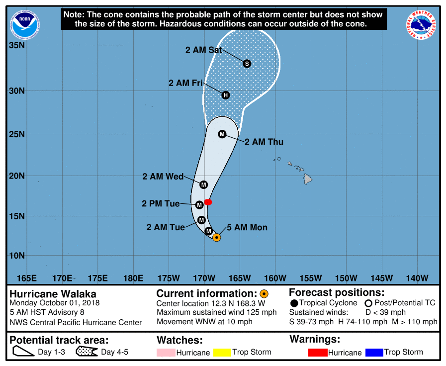
CP012018_5day_cone_no_line_8.png

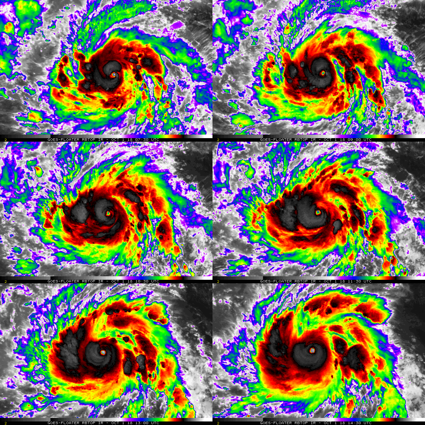
20181001.1301.n20.165bt.01C.WALAKA.105kts.958mb.12.1N.167.9W.100pc.jpg

rbtop-animated.gif
回復

使用道具 舉報

簽到天數: 3279 天

[LV.Master]伴壇終老

t02436|2018-10-1 17:21 | 顯示全部樓層
隔壁棚的Walaka也進入RI,09Z評價90節,巔峰上望135節!
WTPA41 PHFO 010925
TCDCP1

Hurricane Walaka Discussion Number   7
NWS Central Pacific Hurricane Center Honolulu HI   CP012018
1100 PM HST Sun Sep 30 2018

Walaka is undergoing rapid intensification this evening, which is
clearly evident given the large ring of -70 to -85C cloud tops
surrounding the the well defined eye. Additionally, recent
microwave passes indicate that the organization of the system has
improved significantly, while geostationary satellite animations
show well defined outflow channels in all quadrants. The latest
intensity estimates came in at 5.0 (90 knots) from PHFO and SAB, 4.5
(77 knots) from JTWC, while the UW-CIMSS ADT was 4.2 (70 knots).
Based on the significant improvement in appearance and organization
of Walaka, the initial intensity for this advisory was increased to
90 knots. The initial motion was set at 280/10 knots.

Walaka continues to be steered westward this evening by a
subtropical ridge to the north of the system, and this motion is
expected to continue tonight. A turn toward the northwest is
expected on Monday as a deep north Pacific upper trough digs
southward in the vicinity of 30N 170W. A turn toward the north is
then expected on Tuesday, with Walaka continuing on this course
through Tuesday night with an increase in forward speed. The
tropical cyclone should then make a turn toward the north-northeast
Wednesday and Wednesday night as it begins to feel the influence of
the deep upper level trough. The track guidance then suggests a
shift back toward the north with a decrease in forward speed
Thursday through Friday as Walaka interacts with the deep upper
level trough. The official forecast was nudged slightly to the left
through 48 hours, then slightly to the right beyond 48 hours, and
is very close to the HCCA, TVCN, and GFEX consensus guidance.

The environment surrounding Walaka remains very conducive for
additional intensification through 48 hours. The tropical cyclone
will remain within a deep moist airmass, with vertical wind shear
forecast to remain around 10 knots or less through 48 hours, and
sea surface temperatures holding in the 84 to 86 Fahrenheit range
during this time. As a result, additional rapid intensification is
expected tonight and Monday, with the cyclone then forecast to level
off just below category 5 status Tuesday and Tuesday night. Given
the environment surrounding the system, intensification to a
category 5 storm is not out of the question, although none of the
intensity guidance explicitly indicate this at this time.

Additionally, Walaka will likely undergo eyewall replacement cycles
which will lead to some fluctuation in intensity. Beyond 48 hours,
vertical wind shear will steadily increase as Walaka approaches and
begins to interact with the deep upper level trough over the
north-central Pacific, with sea surface temperatures dropping off as
well. The intensity forecast shows a gradual weakening by 72 hours,
with rapid weakening then expected beyond 72 hours through the end
of the forecast period. The official intensity forecast has been
increased from the previous advisory and is in line with the high
end of the intensity guidance.


FORECAST POSITIONS AND MAX WINDS

INIT  01/0900Z 11.9N 167.5W   90 KT 105 MPH
12H  01/1800Z 12.5N 168.7W  115 KT 130 MPH
24H  02/0600Z 13.5N 169.9W  130 KT 150 MPH
36H  02/1800Z 15.1N 170.5W  135 KT 155 MPH
48H  03/0600Z 17.2N 170.5W  135 KT 155 MPH

72H  04/0600Z 23.3N 168.1W  115 KT 130 MPH
96H  05/0600Z 28.5N 167.5W   75 KT  85 MPH
120H  06/0600Z 31.0N 166.0W   60 KT  70 MPH

$$
Forecaster Jelsema
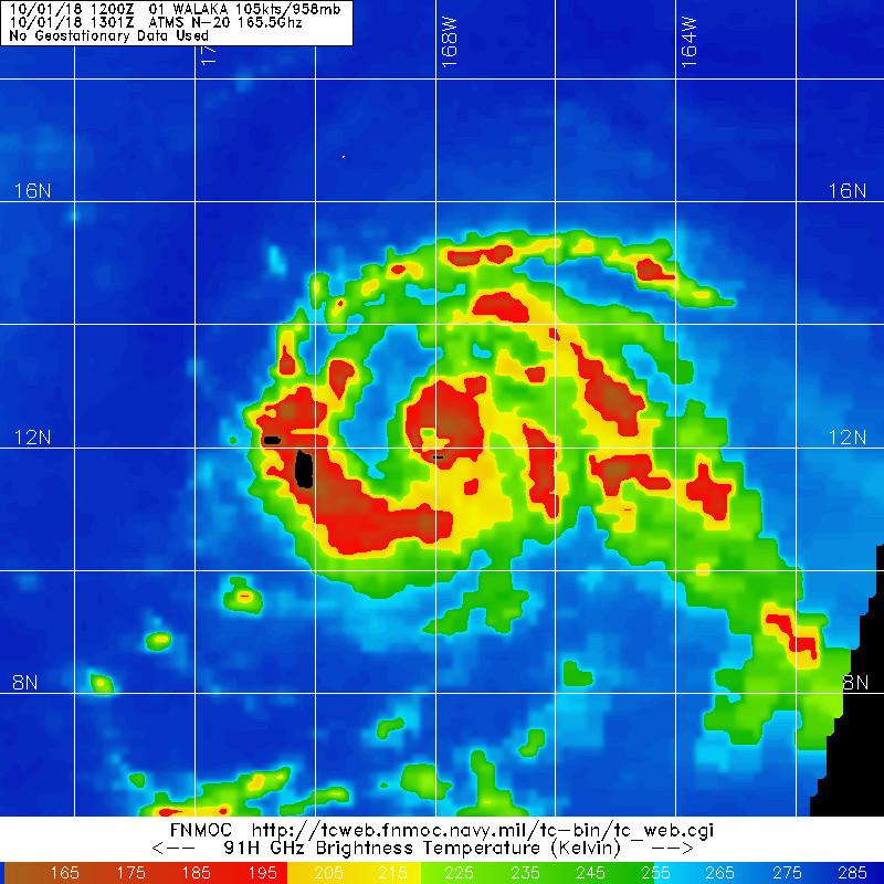
CP012018_5day_cone_no_line_7.png

20181001.0553.f17.91pct91h91v.01C.WALAKA.90kts.970mb.11.8N.167W.075pc.jpg

rbtop-animated.gif
回復

使用道具 舉報

簽到天數: 601 天

[LV.9]以壇為家II

霧峰追風者|2018-9-30 08:40 | 顯示全部樓層
CPHC 21Z命名"WALAKA",巔峰上望MH。
WTPA41 PHFO 292107
TCDCP1

Tropical Storm Walaka Discussion Number   1
NWS Central Pacific Hurricane Center Honolulu HI   CP012018
1100 AM HST Sat Sep 29 2018

The tropical disturbance passing far south of the main Hawaiian
Islands has developed persistent deep convection near the center
with a banding feature developing within the eastern and southern
quadrants. A series of SSMI and SSMIS passes between 1348 and 1716
UTC showed this structure and provided some indication of the
location of the low level circulation center. Subjective Dvorak
current intensity estimates from JTWC and SAB were constrained to
2.0/30 kt, with data T numbers coming in at 2.5/35 kt, and the
current intensity from HFO was 2.5/35 kt. These inputs support
initiating advisories for Tropical Storm Walaka, the sixth tropical
cyclone of 2018 in the Central Pacific basin and the first to form
in the basin this year.

Walaka is moving toward the west (265 degrees) at 13 kt. A westward
motion will continue for the next 36 hours or so as the system
remains south of a deep ridge. This will take Walaka well southwest
of the main Hawaiian Islands. Late Sunday through Monday night, the
cyclone will make a gradual turn toward the northwest then north as
a deep North Pacific trough digs southward and steadily erodes the
ridge. As a result, Walaka will pass very close to Johnston Island
as early as Monday night and likely sometime Tuesday. The deep
trough will stall roughly along 171W longitude on Tuesday, causing
the tropical cyclone to accelerate northward. On days four and
five, the motion becomes uncertain due to model differences in the
handling of the interaction between Walaka with the deep trough. The
track forecast follows a rather tightly clustered guidance envelope
through Tuesday, then favors the HMON, which is closer to TVCE than
the faster GFS and slower ECMWF. Due to the uncertainty in the long
term motion, interests in the Papahanaumokuakea Marine National
Monument should monitor Walaka.

Strengthening, possibly rapid, is expected through the next three
days, and Walaka is forecast to remain intense through day five.
Walaka will remain under low vertical wind shear and over SSTs of
around 29C through at least Monday, and likely into Tuesday. In this
environment, the SHIPS rapid intensification guidance for Walaka is
well above the climatological mean. The intensity forecast is close
to LGEM and ICON through the initial 48 hours and remains near the
HWRF and ICON, but below LGEM, thereafter. Walaka is forecast to
become a hurricane by Sunday, and along the forecast track,
hurricane conditions could be experienced on Johnston Island as
early as Monday night. Some weakening is indicated beyond Tuesday
due to increasing southwesterly vertical wind shear.


FORECAST POSITIONS AND MAX WINDS

INIT  29/2100Z 11.5N 159.1W   35 KT  40 MPH
12H  30/0600Z 11.5N 161.5W   45 KT  50 MPH
24H  30/1800Z 11.8N 164.2W   60 KT  70 MPH
36H  01/0600Z 12.5N 166.6W   75 KT  85 MPH
48H  01/1800Z 13.4N 168.4W   90 KT 105 MPH
72H  02/1800Z 16.5N 169.6W  110 KT 125 MPH
96H  03/1800Z 21.4N 168.5W  100 KT 115 MPH
120H  04/1800Z 27.0N 168.0W   80 KT  90 MPH

$$
Forecaster Wroe
CP012018_5day_cone_no_line_1.png 20180930.0000.himawari-8.vis.01C.INVEST.35kts.1005mb.11.5N.158.6W.100pc.jpg rgb-animated (6).gif rbtop-animated (15).gif


回復

使用道具 舉報

12下一頁
快速回覆
您需要登錄後才可以回帖 登錄 | 立即加入

本版積分規則

霧峰追風者

    主題

    帖子

    220萬

    積分

    16級[四級颶風]

    Rank: 16Rank: 16Rank: 16Rank: 16

16級[四級颶風]

發訊息

本平台僅供學術討論之用,預報應以氣象局為準

威普網站虛擬主機贊助公司

臺灣第一個天氣類型社群平台 即時天氣資訊、精準颱風動態

線上客服
FB傳送訊息
廣告行銷
精準行銷 物超所值
官方粉專
發佈 快速回復 返回頂部 返回列表