開啟輔助訪問
 找回密碼
 立即加入

13E.Henan 近岸發展受限

查看數: 7048 評論數: 5 收藏 0切换到帖子模式
    組圖打開中,請稍候......
發佈時間: 2020-8-23 15:25

正文摘要:

  基本資料   編號    :13 E 擾動編號日期:2020 年 08 月 23 日 15 時 撤編日期  :2020 年 08 月 29 日 18 時 97E.INVEST.20kts-1008mb-15.5N-107.5W 巔峰強度:40KT/1001hPa ...

天篷大元帥 發表於 2020-8-29 08:56
GG
原文:
043
WTPZ43 KNHC 282033
TCDEP3

Post-Tropical Cyclone Hernan Discussion Number  11
NWS National Hurricane Center Miami FL       EP132020
300 PM MDT Fri Aug 28 2020

Satellite imagery, scatterometer data, and surface observations
indicate that Hernan has degenerated into a broad low pressure area
near the southern end of the Baja California peninsula.  The
remnant low is forecast to move generally westward for the next
12-24 h until it is absorbed into the monsoon gyre that includes
Tropical Storm Iselle.

This is the last advisory issued by the National Hurricane Center
on this system.  For additional information on the remnant low
please see High Seas Forecasts issued by the National Weather
Service, under AWIPS header NFDHSFEPI, WMO header FZPN02 KWBC, and
on the web at ocean.weather.gov/shtml/NFDHSFEPI.php


FORECAST POSITIONS AND MAX WINDS

INIT  28/2100Z 23.2N 110.1W   25 KT  30 MPH...POST-TROP/REMNT LOW
12H  29/0600Z 23.3N 111.8W   20 KT  25 MPH...POST-TROP/REMNT LOW
24H  29/1800Z...DISSIPATED

$$
Forecaster Beven

僅供參考的機器翻譯:
043
WTPZ43 KNHC 282033
TCDEP3

後熱帶氣旋埃爾南討論會11
新創建國家颶風中心邁阿密FL EP132020
MDT MPM 300 PM 2020年8月28日

衛星圖像,散射儀數據和表面觀測
表明Hernan已經退化為廣闊的低壓區
下加利福尼亞半島南端附近。的
預計下一個殘余天數將總體向西移動
12-24小時,直到它被吸收到季風迴旋中,包括
熱帶風暴Iselle。

這是國家颶風中心發布的最後一則建議
在這個系統上。有關剩餘電量不足的更多信息
請參閱國家天氣發布的公海預報
服務,位於AWIPS標頭NFDHSFEPI,WMO標頭FZPN02 KWBC和
在網址上ocean.weather.gov/shtml/NFDHSFEPI.php


預測位置和最大風

初始化28 / 2100Z 23.2N 110.1W 25 KT 30 MPH ...
12H 29 / 0600Z 23.3N 111.8W 20 KT 25 MPH ...
24H 29 / 1800Z ...已分發

$$
預報員貝文
老農民版夜神月 發表於 2020-8-29 00:53
13E已減弱為TD
即將登陸下加利福尼亞半島,並進一步減弱為殘餘低氣壓
000
WTPZ43 KNHC 281442
TCDEP3

Tropical Depression Hernan Discussion Number  10
NWS National Hurricane Center Miami FL       EP132020
900 AM MDT Fri Aug 28 2020

Satellite imagery shows that Hernan has become less organized since
the last advisory with most of the associated convection
dissipating.  In addition, surface observations in the coastal
areas near the cyclone suggest the possibility that it no longer
has a closed circulation, although there are no observations over
water to confirm this.  Based on decreasing satellite intensity
estimates, Hernan is downgraded to a tropical depression.  
Additional weakening is forecast, and Hernan is expected to
degenerate to a remnant low pressure area as it moves over the Baja
California peninsula later today and tonight.  The system is then
expected to weaken to a trough on Saturday.

The initial motion is a somewhat uncertain 295/18.  Hernan is
moving around the northeastern side of the monsoon gyre that
contains Tropical Storm Iselle, and a general west-northwestward
motion is expected until the system dissipates on Saturday.


FORECAST POSITIONS AND MAX WINDS

INIT  28/1500Z 23.4N 109.1W   30 KT  35 MPH
12H  29/0000Z 24.1N 110.5W   20 KT  25 MPH...POST-TROP/REMNT LOW
24H  29/1200Z...DISSIPATED

$$
Forecaster Beven

145036_5day_cone_with_line_and_wind.png 20200828.1620.goes-17.ir.13E.HERNAN.30kts.1006mb.23.1N.108.6W.100pc.jpg
GOES16302020241FcicIO.jpg 20200828.1610.goes-17.vis.2km.13E.HERNAN.30kts.1006mb.23.1N.108.6W.pc.jpg
霧峰追風者 發表於 2020-8-27 09:59
000
WTPZ43 KNHC 262045
TCDEP3

Tropical Storm Hernan Discussion Number   3
NWS National Hurricane Center Miami FL       EP132020
400 PM CDT Wed Aug 26 2020

Despite the rather poor presentation in satellite imagery, a recent
ASCAT overpass showed that tropical-storm-force winds partially
associated with a broader scale monsoon gyre are occurring over the
southern portion of the circulation about 50-90 n mi from the
center. Based on the wind data, the initial intensity has been
raised to 35 kt, and the depression has been upgraded to Tropical
Storm Hernan.

Hernan is a sheared tropical cyclone, with only a small area of deep
convection just to the south of the center. The SHIPS guidance
indicates that this shear will continue throughout the forecast
period. While the cyclone remains over very warm waters of about 29
degrees C for the next 24-36 h, there should be sufficient
convection to maintain Hernan's current intensity. However, after 36
h the cyclone will move over relatively cooler waters of about 26
C. These very marginal water temperatures combined with the ongoing
shear should cause Hernan to weaken, and the system is expected to
degenerate to a remnant low by 60 h, as indicated by the GFS
simulated satellite. The NHC intensity is a blend of the various
corrected consensus aids and the SHIPS intensity guidance.

Hernan appears to have made its anticipated turn to the northeast
and the initial motion is 040/5 kt. The cyclone is expected to  turn
north then northwest over the next 24 h as it pivots around inside a
cyclonic gyre that includes Tropical Depression Fourteen-E to its
west. After that time, Hernan should be steered west-northwestward
to westward by a mid-tropospheric ridge anchored over the
southwestern U.S.. On this forecast track, Hernan and most of its
winds and convection should remain just offshore the southwestern
coast of Mexico today and Thursday, and pass near or just south of
the southern tip of Baja California Sur on Friday and Saturday. The
official NHC forecast is little changed from the previous one, and
is near the various consensus aids.


FORECAST POSITIONS AND MAX WINDS

INIT  26/2100Z 17.7N 105.8W   35 KT  40 MPH
12H  27/0600Z 18.4N 105.7W   35 KT  40 MPH
24H  27/1800Z 19.5N 106.1W   35 KT  40 MPH
36H  28/0600Z 20.7N 107.3W   35 KT  40 MPH
48H  28/1800Z 21.7N 108.9W   30 KT  35 MPH
60H  29/0600Z 22.2N 110.7W   30 KT  35 MPH...POST-TROP/REMNT LOW
72H  29/1800Z 22.5N 112.7W   25 KT  30 MPH...POST-TROP/REMNT LOW
96H  30/1800Z 22.4N 115.1W   20 KT  25 MPH...POST-TROP/REMNT LOW
120H  31/1800Z...DISSIPATED

$$
Forecaster Latto
204647_5day_cone_no_line_and_wind.png 20200827.0130.goes-17.ir.13E.HERNAN.35kts.1004mb.18N.105.8W.100pc.jpg 20200827.0130.goes-17.ircolor.13E.HERNAN.35kts.1004mb.18N.105.8W.100pc.jpg
老農民版夜神月 發表於 2020-8-24 00:26
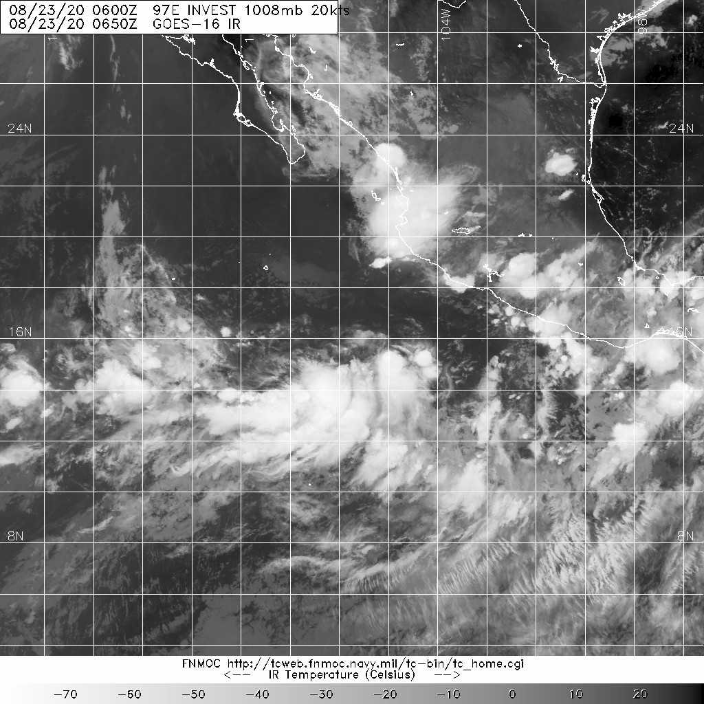
本帖最後由 老農民版夜神月 於 2020-8-24 02:01 編輯

NHC展望提升至High,70%;
JTWC發布TCFA
1. An elongated area of low pressure located several hundred miles
south of the southern tip of the Baja California peninsula
continues to produce a large area of disorganized cloudiness and
thunderstorms.  Conditions appear favorable for development, and a
tropical depression is expected to form during the next couple of
days while the system meanders or drifts northward a few hundred
miles offshore the coast of southwestern Mexico.
* Formation chance through 48 hours...high...70 percent.
* Formation chance through 5 days...high...90 percent.
WTPN21 PHNC 231500
MSGID/GENADMIN/JOINT TYPHOON WRNCEN PEARL HARBOR HI//
SUBJ/TROPICAL CYCLONE FORMATION ALERT (INVEST 97E)//
RMKS/
1. FORMATION OF A SIGNIFICANT TROPICAL CYCLONE IS POSSIBLE WITHIN
115 NM EITHER SIDE OF A LINE FROM 15.3N 107.9W TO 17.9N 108.0W
WITHIN THE NEXT 12 TO 24 HOURS. AVAILABLE DATA DOES NOT JUSTIFY
ISSUANCE OF NUMBERED TROPICAL CYCLONE WARNINGS AT THIS TIME.
WINDS IN THE AREA ARE ESTIMATED TO BE 15 TO 20 KNOTS. METSAT
IMAGERY AT 231200Z INDICATES THAT A CIRCULATION CENTER IS LOCATED
NEAR 15.4N 107.4W. THE SYSTEM IS MOVING EAST-SOUTHEASTWARD AT 04
KNOTS.
2. REMARKS: AN AREA OF CONVECTION (INVEST 97E) HAS PERSISTED NEAR
15.4N 107.4W, APPROXIMATELY 1098 NM SOUTH-SOUTHEAST OF SAN DIEGO.
ANIMATED MULTISPECTRAL SATELLITE IMAGERY DEPICTS PERSISTENT DEEP
CONVECTION OVERHEAD AN ELONGATED LOW LEVEL CIRCULATION. A 231148Z
SSMIS 91GHZ MICROWAVE IMAGE REVEALS DEEP CONVECTION DIRECTLY
OVERHEAD THE LOW LEVEL CIRCULATION WITH FORMATIVE BANDING TO THE
SOUTH. 97E IS CURRENTLY IN A FAVORABLE ENVIRONMENT FOR DEVELOPMENT
WITH GOOD EQUATORWARD OUTFLOW, LOW (<15 KTS) VERTICAL WIND SHEAR,
AND WARM (28 TO 29 CELSIUS) SEA SURFACE TEMPERATURES. GLOBAL MODELS
ARE IN DISAGREEMENT IN REGARDS TO 97E WITH GFS SHOWING A GENERALLY
NORTHWARD TRACK WHILE INTENSIFYING AND ECMWF SHOWING LITTLE TO NO
DEVELOPMENT. MAXIMUM SUSTAINED SURFACE WINDS ARE ESTIMATED AT 15 TO
20 KNOTS. MINIMUM SEA LEVEL PRESSURE IS ESTIMATED TO BE NEAR 1007
MB. THE POTENTIAL FOR THE DEVELOPMENT OF A SIGNIFICANT TROPICAL
CYCLONE WITHIN THE NEXT 24 HOURS IS HIGH.
3. THIS ALERT WILL BE REISSUED, UPGRADED TO WARNING OR CANCELLED BY
241500Z.//
NNNN

ep9720.gif two_pac_2d1.png
20200823.1540.goes-17.ir.97E.INVEST.20kts.1008mb.15.4N.107.4W.100pc.jpg 20200823.1418.f17.composite.97E.INVEST.20kts.1008mb.15.4N.107.4W.070pc.jpg

評分

參與人數 1水氣能量 +15 收起 理由
king111807 + 15 TCFA

查看全部評分

本平台僅供學術討論之用,預報應以氣象局為準

威普網站虛擬主機贊助公司

臺灣第一個天氣類型社群平台 即時天氣資訊、精準颱風動態

線上客服
FB傳送訊息
廣告行銷
精準行銷 物超所值
官方粉專
發佈 快速回復 返回頂部 返回列表