開啟輔助訪問
 找回密碼
 立即加入

17P.Lucas 曾增強至澳式C2 轉化溫氣

簽到天數: 1650 天

[LV.Master]伴壇終老

老農民版夜神月|2021-1-30 11:19 | 顯示全部樓層
JTWC0330Z發布TCFA
WTPS21 PGTW 300330
MSGID/GENADMIN/JOINT TYPHOON WRNCEN PEARL HARBOR HI//
SUBJ/TROPICAL CYCLONE FORMATION ALERT (INVEST 94P)//
RMKS/
1. FORMATION OF A SIGNIFICANT TROPICAL CYCLONE IS POSSIBLE WITHIN
120 NM EITHER SIDE OF A LINE FROM 13.2S 147.9E TO 13.8S 154.6E
WITHIN THE NEXT 12 TO 24 HOURS. AVAILABLE DATA DOES NOT JUSTIFY
ISSUANCE OF NUMBERED TROPICAL CYCLONE WARNINGS AT THIS TIME.
WINDS IN THE AREA ARE ESTIMATED TO BE 25 TO 30 KNOTS. METSAT
IMAGERY AT 300000Z INDICATES THAT A CIRCULATION CENTER IS LOCATED
NEAR 13.2S 148.2E. THE SYSTEM IS MOVING EAST-SOUTHEASTWARD AT 07
KNOTS.
2. REMARKS: THE AREA OF CONVECTION (INVEST 94P) PREVIOUSLY LOCATED
NEAR 14.4S 143.6E IS NOW LOCATED NEAR 13.2S 148.2E, APPROXIMATELY
260NM NORTH EAST OF CAIRNS, AUSTRALIA. ANIMATED MULTISPECTRAL
SATELLITE IMAGERY AND A 292253Z METOP-B 89 GHZ MICROWAVE IMAGE DEPICT
CONVECTIVE BANDING WRAPPING INTO A CONSOLIDATING LOW LEVEL CIRCULATION
CENTER. A PARTIAL 292254Z ASCAT-B PASS INDICATES A DEFINED CIRCULATION
WITH 25-30KT WINDS IN THE NORTHEAST PERIPHERY. ENVIRONMENTAL ANALYSIS
DEPICTS A FAVORABLE ENVIRONMENT FOR DEVELOPMENT WITH GOOD EQUATORWARD AND
EASTWARD OUTFLOW ALOFT, LOW (10-15KTS) VERTICAL WIND SHEAR, WARM (30-31C)
SEA SURFACE TEMPERATURES. GLOBAL MODELS ARE IN GENERAL AGREEMENT THAT
INVEST 94P WILL TRACK EAST-SOUTHEASTWARD AS IT INTENSIFIES OVER THE NEXT
24 HOURS. MAXIMUM SUSTAINED SURFACE WINDS ARE ESTIMATED AT 25 TO 30
KNOTS. MINIMUM SEA LEVEL PRESSURE IS ESTIMATED TO BE NEAR 1000 MB. THE
POTENTIAL FOR THE DEVELOPMENT OF A SIGNIFICANT TROPICAL CYCLONE
WITHIN THE NEXT 24 HOURS IS HIGH.
3. THIS ALERT WILL BE REISSUED, UPGRADED TO WARNING OR CANCELLED BY
310330Z.
//
NNNN
sh9421.gif 20210130.0250.himawari-8.vis.94P.INVEST.25kts.1002mb.13.2S.148.2E.100pc.jpg
回復

使用道具 舉報

簽到天數: 2095 天

[LV.Master]伴壇終老

周子堯@FB|2021-1-29 14:24 | 顯示全部樓層
JTWC 評級 Medium,預估未來強度可達澳式C1~C2以上

(1) THE AREA OF CONVECTION (INVEST 94P) PREVIOUSLY LOCATED NEAR
14.7S 142.9E IS NOW LOCATED NEAR 14.4S 143.6E, APPROXIMATELY 199 NM
NORTHWEST OF CAIRNS, AUSTRALIA. ANIMATED MULTISPECTRAL SATELLITE IMAGERY
AND RADAR DEPICT LOW-LEVEL CLOUD TURNING WITH CONVECTION TO THE NORTH.
UPPER LEVEL ANALYSIS INDICATES A FAVORABLE ENVIRONMENT WITH GOOD
EQUATORWARD OUTFLOW AND LOW VERTICAL WIND SHEAR (10-15 KTS). WHILE THE
INVEST REMAINS OVER LAND, GLOBAL MODELS INDICATE THAT IT WILL CONTINUE TO
MOVE EASTWARD AND SHOWS POTENTIAL FOR INTENSIFICATION IN THE NEXT FEW
DAYS. MAXIMUM SUSTAINED SURFACE WINDS ARE ESTIMATED AT 15 TO 20 KNOTS.
MINIMUM SEA LEVEL PRESSURE IS ESTIMATED TO BE NEAR 999 MB. THE POTENTIAL
FOR THE DEVELOPMENT OF A SIGNIFICANT TROPICAL CYCLONE WITHIN THE NEXT 24
HOURS IS UPGRADED TO MEDIUM.
abpwsair.jpg
94P_gefs_latest.png
20210129.0550.himawari-8.vis.94P.INVEST.20kts.999mb.14.6S.143.4E.100pc.jpg
回復

使用道具 舉報

簽到天數: 1650 天

[LV.Master]伴壇終老

老農民版夜神月|2021-1-29 03:37 | 顯示全部樓層
數值對94P二度發展的反應明顯,BoM亦持續關注中
The monsoon trough continues to extend across the Gulf of Carpentaria and central Cape York Peninsula and into the northern Coral Sea.

A tropical low that is currently located over Cape York Peninsula is likely to meander across the area today then shift eastwards and emerge over the northwestern Coral Sea, most likely late on Friday or on Saturday. The environment is forecast to be conducive for tropical cyclone development with a MODERATE chance from Sunday. The tropical system is expected to move eastwards or southeastwards away from the Queensland east coast.

Likelihood of this system being a tropical cyclone in the Eastern Region on:
Friday:
Very Low
Saturday:
Low
Sunday:
Moderate
20210128.1900.himawari-8.ir.94P.INVEST.20kts.999mb.14.7S.143.1E.100pc.jpg 20210128.1558.gw1.89pct89h89v.94P.INVEST.20kts.999mb.14.7S.142.9E.91pc.jpg
EC
#!001_MicrosoftEdge_User_Default_WebNotes_Microsoft-Edge-Web-Notes-Windy-Win14195468.jpg
GFS系集
94P_gefs_latest.png
回復

使用道具 舉報

簽到天數: 1650 天

[LV.Master]伴壇終老

老農民版夜神月|2021-1-27 13:59 | 顯示全部樓層
JTWC降評Low
(1) THE AREA OF CONVECTION (INVEST 94P) PREVIOUSLY LOCATED
NEAR 15.6S 140.1E IS NOW LOCATED NEAR 15.8S 142.3E, APPROXIMATELY
187 NM SOUTH OF WEIPA, AUSTRALIA. ANIMATED ENHANCED INFRARED
SATELLITE IMAGERY AND A 270200Z GMI 89GHZ MICROWAVE IMAGE DEPICT A
DEFINED LOW LEVEL CIRCULATION OVER LAND WITH DISORGANIZED
CONVECTION. UPPER LEVEL ANALYSIS INDICATES A MARGINALLY FAVORABLE
ENVIRONMENT FOR DEVELOPMENT WITH FAIR OUTFLOW ALOFT AND LOW VERTICAL
WIND SHEAR (<15KTS). HOWEVER, THE SYSTEM IS OVER LAND, WHICH IS
HINDERING ANY SIGNIFICANT DEVELOPMENT. GLOBAL MODELS INDICATE INVEST
94P WILL TRACK SLOWLY NORTHEASTWARD OVER THE CAPE YORK PENINSULA FOR
THE NEXT TWO DAYS OR LONGER. MAXIMUM SUSTAINED SURFACE WINDS ARE
ESTIMATED AT 15 TO 20 KNOTS. MINIMUM SEA LEVEL PRESSURE IS ESTIMATED
TO BE NEAR 1000 MB. THE POTENTIAL FOR THE DEVELOPMENT OF A
SIGNIFICANT TROPICAL CYCLONE WITHIN THE NEXT 24 HOURS IS DOWNGRADED
TO LOW.
20210127.0530.himawari-8.vis.94P.INVEST.20kts.1002mb.14.7S.142.6E.100pc.jpg 20210127.0424.gw1.89pct89h89v.94P.INVEST.20kts.1002mb.14.7S.142.6E.78pc.jpg
20210127.0424.gw1.89hbt.94P.INVEST.20kts.1002mb.14.7S.142.6E.78pc.jpg
回復

使用道具 舉報

簽到天數: 483 天

[LV.9]以壇為家II

dom|2021-1-27 09:20 | 顯示全部樓層
BoM新報不再看好成旋
94P INVEST 210127 0000 14.7S 142.6E SHEM 20 1002
IDQ65001.png 94P_tracks_latest.png ir-animated.gif
回復

使用道具 舉報

簽到天數: 601 天

[LV.9]以壇為家II

霧峰追風者|2021-1-27 07:57 | 顯示全部樓層
IDQ20018
TROPICAL CYCLONE TECHNICAL BULLETIN: AUSTRALIA - EASTERN REGION
Issued by AUSTRALIAN BUREAU OF METEOROLOGY TROPICAL CYCLONE WARNING CENTRE
at: 1930 UTC 26/01/2021
Name: Tropical Low  
Identifier: 11U
Data At: 1800 UTC
Latitude: 14.9S
Longitude: 141.4E
Location Accuracy: within 30 nm [55 km]
Movement Towards: east northeast [063 deg]
Speed of Movement: 4 knots [8 km/h]
Maximum 10-Minute Wind: 25 knots [45 km/h]
Maximum 3-Second Wind Gust: 45 knots [85 km/h]
Central Pressure: 999 hPa
Radius of 34-knot winds NE quadrant:   
Radius of 34-knot winds SE quadrant:   
Radius of 34-knot winds SW quadrant:   
Radius of 34-knot winds NW quadrant:   
Radius of 48-knot winds NE quadrant:   
Radius of 48-knot winds SE quadrant:   
Radius of 48-knot winds SW quadrant:   
Radius of 48-knot winds NW quadrant:   
Radius of 64-knot winds:
Radius of Maximum Winds:   
Dvorak Intensity Code: T2.0/2.0/D0.5/24HRS STT:S0.0/06HRS
Pressure of outermost isobar: 1001 hPa
Radius of outermost closed isobar: 40 nm [75 km]
FORECAST DATA
Date/Time    : Location    : Loc. Accuracy: Max Wind   : Central Pressure
[UTC]        : degrees     :      nm  [km]: knots[km/h]: hPa
+06:  27/0000: 15.0S 141.6E:     045 [085]:  030  [055]:  995
+12:  27/0600: 15.1S 141.6E:     060 [105]:  030  [055]:  994
+18:  27/1200: 15.2S 141.5E:     065 [120]:  030  [055]:  992
+24:  27/1800: 15.2S 141.3E:     075 [135]:  035  [065]:  990
+36:  28/0600: 15.1S 141.2E:     085 [160]:  045  [085]:  985
+48:  28/1800: 14.9S 141.3E:     105 [195]:  050  [095]:  981
+60:  29/0600: 14.4S 141.5E:     120 [220]:  060  [110]:  978
+72:  29/1800: 13.8S 142.1E:     130 [245]:  045  [085]:  984
+96:  30/1800: 13.2S 144.3E:     165 [310]:  030  [055]:  996
+120: 31/1800: 13.9S 146.6E:     195 [355]:  030  [055]:  996
REMARKS:
The satellite signature of tropical low 11U has shown significant weakening with
loss of deep convection over the last 3 to 6 hours, possibly due to land
interaction as the low moves closer to the coast. 11U was located using a
combination of microwave [AMSR at 1610Z], satellite, and surface observations,
with moderate confidence. An ASCAT pass at 1131Z showed an elongated trough with
25kt winds on the northeast side of the centre, indicative of a disorganised
structure. Radar suggests the mid-level circulation is offset to the east of the
low-level centre. The monsoon flow to the north has also weakened slightly over
the last 12 hours.

Dvorak analysis was based on a curved band pattern with a 0.25 wrap, giving DT
1.5. However FT is held at 2.0 due to constraints for lowering at night.
Similarly, intensity is held at 25 knots based on the earlier ASCAT pass.

CIMSS satellite winds depict the system lying under highly diffluent upper level
flow with well defined outflow channels to the north and south due to an upper
level trough rotating onto the system overnight. Deep layer wind shear over the
system is estimated at about 10 knots easterly. Sea surface temperatures are
around 30 to 31 degrees. While the environment is generally favourable for
development, the system's proximity to land is a complicating factor, so its
cyclogenesis potential is largely dependant on its time over water.  

Steering influences on the system are currently fairly well balanced, with
mid-level ridges to the southwest and northeast. The system is therefore likely
to remain fairly slow-moving over the eastern Gulf for a period. In the longer
term the northern steering ridge is expected to become dominant as the southern
ridge is eroded by a mid-level trough. From late in the week the system should
recommence easterly motion, crossing Cape York Peninsula and potentially
emerging into the Coral Sea. However, there remains significant variation in
model guidance, with both a faster easterly movement, or further stalling in the
Gulf both possible scenarios.

Given the current and forecast favourable environment for development, if the
system remains over Gulf waters, it is likely to intensify to at least category
2. However some uncertainty exists with some guidance suggesting it may cross
the coast before tropical cyclone development can occur.

Copyright Commonwealth of Australia
==
The next bulletin for this system will be issued by: 27/0130 UTC.
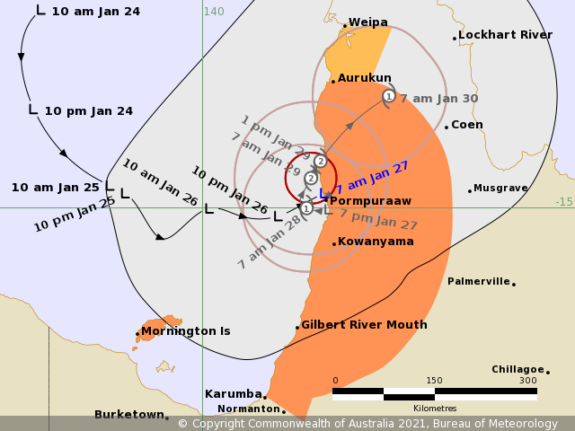
IDQ65001.png
回復

使用道具 舉報

簽到天數: 1650 天

[LV.Master]伴壇終老

老農民版夜神月|2021-1-26 15:17 | 顯示全部樓層
BoM上望60節
IDQ20018
TROPICAL CYCLONE TECHNICAL BULLETIN: AUSTRALIA - EASTERN REGION
Issued by AUSTRALIAN BUREAU OF METEOROLOGY TROPICAL CYCLONE WARNING CENTRE
at: 0700 UTC 26/01/2021
Name: Tropical Low  
Identifier: 11U
Data At: 0600 UTC
Latitude: 15.1S
Longitude: 140.5E
Location Accuracy: within 30 nm [55 km]
Movement Towards: east southeast [105 deg]
Speed of Movement: 4 knots [7 km/h]
Maximum 10-Minute Wind: 25 knots [45 km/h]
Maximum 3-Second Wind Gust: 45 knots [85 km/h]
Central Pressure: 999 hPa
Radius of 34-knot winds NE quadrant:   
Radius of 34-knot winds SE quadrant:   
Radius of 34-knot winds SW quadrant:   
Radius of 34-knot winds NW quadrant:   
Radius of 48-knot winds NE quadrant:   
Radius of 48-knot winds SE quadrant:   
Radius of 48-knot winds SW quadrant:   
Radius of 48-knot winds NW quadrant:   
Radius of 64-knot winds:
Radius of Maximum Winds:   
Dvorak Intensity Code: T2.0/2.0/D1.5/18HRS STT:S0.0/06HRS
Pressure of outermost isobar: 1001 hPa
Radius of outermost closed isobar: 120 nm [220 km]
FORECAST DATA
Date/Time    : Location    : Loc. Accuracy: Max Wind   : Central Pressure
[UTC]        : degrees     :      nm  [km]: knots[km/h]: hPa
+06:  26/1200: 15.2S 140.7E:     045 [085]:  030  [055]:  995
+12:  26/1800: 15.4S 140.7E:     060 [105]:  030  [055]:  994
+18:  27/0000: 15.5S 140.8E:     065 [120]:  030  [055]:  994
+24:  27/0600: 15.5S 140.7E:     075 [135]:  030  [055]:  994
+36:  27/1800: 15.5S 140.5E:     085 [160]:  045  [085]:  986
+48:  28/0600: 15.5S 140.5E:     105 [195]:  050  [095]:  982
+60:  28/1800: 15.3S 140.5E:     120 [220]:  055  [100]:  979
+72:  29/0600: 14.8S 141.0E:     130 [245]:  060  [110]:  976
+96:  30/0600: 14.1S 142.2E:     165 [310]:  040  [075]:  990
+120: 31/0600: 14.4S 143.9E:     195 [355]:  030  [055]:  995
REMARKS:
The satellite signature of tropical low 11U has remained overall steady during
the last 6 hours. Loose banding has developed through the western and northern
flanks, while a separate area of convection has persisted to the southeast of
the estimated low level centre. The 00Z ASCAT pass suggested the centre remained
slightly elongated, and current satellite and radar imagery suggests the system
still has yet to consolidate around a single well defined centre. 11U was
located using a combination of radar, satellite, and surface observations.
Proximal surface pressures from the latter indicate the surface centre may be
further from the coast than recent radar imagery would suggest.

Dvorak analysis was based on a curved band pattern with an 0.35 wrap, giving DT
2.0. FT is also 2.0. Intensity is estimated at 25 knots based on the morning
ASCAT pass.

CIMSS satellite winds depict the system lying under highly diffluent upper level
flow with well defined outflow channels to the north and south. Deep layer wind
shear over the system is estimated at about 15 knots easterly, which has reduced
considerably from the 00Z estimate. Sea surface temperatures are around 30 to 31
degrees. The evolution of this environment is somewhat complex, but most NWP
guidance suggests the upper level shortwave to the south will rotate northwards
over the system in the next 12 to 18 hours. This would result in a period of
increased westerly shear overnight, followed by another decrease. The system's
proximity to land is another complicating factor. Deterministic NWP guidance
suggests continued development of the system through the next 48 hours, as does
the latest SHIPS guidance.

Overnight, the steering influences on the system are expected to become weak
with mid-level ridges to the southwest and northeast. The system is therefore
likely to stall over the eastern Gulf for a period. In the longer term the
northern steering ridge is expected to become dominant as the southern ridge is
eroded by a mid-level trough. From late in the week the system should recommence
easterly motion, crossing Cape York Peninsula and potentially emerging into the
Coral Sea.

Given the current and forecast favourable environment for development, it is
likely that the system will intensify to at least category 2 over the Gulf,
possibly category 3 depending on how much time it spends over water. However
some uncertainty exists with some guidance suggesting it may cross the coast
before tropical cyclone development can occur.


Copyright Commonwealth of Australia
==
IDQ65001 (5).png 20210126.0640.himawari-8.vis.94P.INVEST.25kts.1000mb.15.5S.140.5E.100pc.jpg
回復

使用道具 舉報

簽到天數: 601 天

[LV.9]以壇為家II

霧峰追風者|2021-1-26 09:54 | 顯示全部樓層
JTWC 評級提升Medium。
(1) THE AREA OF CONVECTION (INVEST 94P) PREVIOUSLY LOCATED
NEAR 14.8S 139.2E IS NOW LOCATED NEAR 15.8S 140.1E, APPROXIMATELY 75
NM NORTHEAST OF MORRINGTON, AUSTRALIA. ANIMATED MULTISPECTRAL
SATELLITE IMAGERY DEPICTS CYCLING DEEP CONVECTION OVER A BROAD LOW
LEVEL CIRCULATION (LLC) WITH ADDITIONAL FLARING CONVECTION TO THE
NORTHEAST. A 251852Z SSMS 91 GHZ IMAGE REVEALS DISORGANIZED BANDING
WRAPPING INTO THE LLC. UPPER LEVEL ANALYSIS INDICATES A MODERATELY
FAVORABLE ENVIRONMENT WITH EQUATORWARD AND EASTWARD OUTFLOW AND WARM
(29-31C) SEA SURFACE TEMPERATURES OFFSET BY MODERATE TO HIGH
VERTICAL WIND SHEAR (20-25KTS). GLOBAL MODELS INDICATE 94P TRAVELING
GENERALLY EASTWARD AS IT INTENSIFIES. MAXIMUM SUSTAINED SURFACE
WINDS ARE ESTIMATED AT 20 TO 25 KNOTS. MINIMUM SEA LEVEL PRESSURE IS
ESTIMATED TO BE NEAR 1000 MB. THE POTENTIAL FOR THE DEVELOPMENT OF A
SIGNIFICANT TROPICAL CYCLONE WITHIN THE NEXT 24 HOURS IS UPGRADED TO
MEDIUM.
abpwsair.jpg


回復

使用道具 舉報

快速回覆
您需要登錄後才可以回帖 登錄 | 立即加入

本版積分規則

本平台僅供學術討論之用,預報應以氣象局為準

威普網站虛擬主機贊助公司

臺灣第一個天氣類型社群平台 即時天氣資訊、精準颱風動態

線上客服
FB傳送訊息
廣告行銷
精準行銷 物超所值
官方粉專
發佈 快速回復 返回頂部 返回列表