開啟輔助訪問
 找回密碼
 立即加入

22S.Marian 曾短暫增強至澳式C4 逐漸南下減弱

簽到天數: 483 天

[LV.9]以壇為家II

2021-2-23 16:44 | 顯示全部樓層
  四級強烈熱帶氣旋  
編號:15 U ( 22 S )
名稱:Marian
rb0-lalo.gif
  基本資料  
擾動編號日期:2021 02 23 16
JTWC升格日期:2021 02 26 08
命名日期  :2021 02 26 14
撤編日期  :2021 03 08 14
登陸地點  :


  巔峰時期資料  
近中心最強風速
澳洲氣象局 (BoM):90 kt
聯合颱風警報中心(JTWC):100 kt ( TY )
海平面最低氣壓   :950 百帕

  擾動編號資料  

98S.INVEST.15kts-1010mb-13.6S-122.5E a34f8618367adab4bf9386099cd4b31c8601e494.jpg
以上資料來自:BoM、JTWC、颱風論壇整理製作

評分

參與人數 1水氣能量 +15 +1 收起 理由
t02436 + 15 + 1

查看全部評分

回復

使用道具 舉報

簽到天數: 483 天

[LV.9]以壇為家II

dom|2021-3-6 15:23 | 顯示全部樓層
JTWC06Z降格TD
22S MARIAN 210306 0600 26.3S 96.5E SHEM 25 1000
TPXS10 PGTW 060608

A. TROPICAL CYCLONE 22S (MARIAN)

B. 06/0515Z

C. 26.28S

D. 96.53E

E. FIVE/GOES-IO

F. N/A

G. IR/EIR/VIS/MSI

H. REMARKS: 63A/PBO PRLY ORGNZD LLCC/ANMTN. THIS SYSTEM IS TOO
WEAK TO CLASSIFY.

I. ADDITIONAL POSITIONS: NONE


MARTIN

回復

使用道具 舉報

簽到天數: 483 天

[LV.9]以壇為家II

dom|2021-3-6 11:00 | 顯示全部樓層
JTWC03Z發佈Final Warning
WTXS31 PGTW 060300
MSGID/GENADMIN/JOINT TYPHOON WRNCEN PEARL HARBOR HI//
SUBJ/TROPICAL CYCLONE 22S (MARIAN) WARNING NR 017//
RMKS/
1. TROPICAL CYCLONE 22S (MARIAN) WARNING NR 017   
   02 ACTIVE TROPICAL CYCLONES IN SOUTHIO
   MAX SUSTAINED WINDS BASED ON ONE-MINUTE AVERAGE
   WIND RADII VALID OVER OPEN WATER ONLY
    ---
   WARNING POSITION:
   060000Z --- NEAR 25.8S 95.9E
     MOVEMENT PAST SIX HOURS - 165 DEGREES AT 07 KTS
     POSITION ACCURATE TO WITHIN 045 NM
     POSITION BASED ON CENTER LOCATED BY SATELLITE
   PRESENT WIND DISTRIBUTION:
   MAX SUSTAINED WINDS - 035 KT, GUSTS 045 KT
   WIND RADII VALID OVER OPEN WATER ONLY
   BECOMING EXTRATROPICAL
   RADIUS OF 034 KT WINDS - 105 NM NORTHEAST QUADRANT
                            095 NM SOUTHEAST QUADRANT
                            110 NM SOUTHWEST QUADRANT
                            085 NM NORTHWEST QUADRANT
   REPEAT POSIT: 25.8S 95.9E
    ---
   FORECASTS:
   12 HRS, VALID AT:
   061200Z --- 26.7S 96.2E
   MAX SUSTAINED WINDS - 035 KT, GUSTS 045 KT
   WIND RADII VALID OVER OPEN WATER ONLY
   BECOMING EXTRATROPICAL
   RADIUS OF 034 KT WINDS - 060 NM NORTHEAST QUADRANT
                            140 NM SOUTHEAST QUADRANT
                            140 NM SOUTHWEST QUADRANT
                            060 NM NORTHWEST QUADRANT
   VECTOR TO 24 HR POSIT: 175 DEG/ 04 KTS
    ---
   24 HRS, VALID AT:
   070000Z --- 27.5S 96.3E
   MAX SUSTAINED WINDS - 030 KT, GUSTS 040 KT
   WIND RADII VALID OVER OPEN WATER ONLY
   EXTRATROPICAL
    ---
REMARKS:
060300Z POSITION NEAR 26.0S 96.0E.
06MAR21. TROPICAL CYCLONE 22S (MARIAN), LOCATED APPROXIMATELY
1018 NM WEST-SOUTHWEST OF LEARMONTH, AUSTRALIA, HAS TRACKED
SOUTH-SOUTHEASTWARD AT 07 KNOTS OVER THE PAST SIX HOURS. ANIMATED
MULTISPECTRAL (MSI) SATELLITE IMAGERY INDICATES TC 22S IS BECOMING
SUBTROPICAL, WITH DEEP CONVECTION DISPLACED WELL TO THE SOUTH OF THE
LOW LEVEL CIRCULATION CENTER (LLCC) DUE TO SIGNIFICANT (30-40 KNOTS)
VERTICAL WIND SHEAR. THE INITIAL POSITION IS PLACED WITH GOOD
CONFIDENCE BASED ON THE ERODING MSI LLCC. THE INITIAL INTENSITY IS
ASSESSED AT 35 KNOTS, WHICH IS HIGHER THAN AGENCY FIXES BASED ON
EARLIER ASCAT DATA INDICATING GALES PERSISTING AROUND THE REMNANT
LLCC. THE SYSTEM IS TRACKING SOUTHWARD ALONG THE WESTERN PERIPHERY
OF A LOW TO MID-LEVEL SUBTROPICAL RIDGE (STR) LOCATED TO THE EAST.
TC 22S WILL CONTINUE TO TRACK SOUTHWARD THROUGHOUT THE SUBTROPICAL
TRANSITION. MARIAN IS EXPECTED TO WEAKEN BELOW 35 KNOTS IN 24 HOURS,
HOWEVER, GIVEN THE CURRENT ASSESSMENT OF PHASE STATE AND PRESENCE OF
GALE WINDS, THE FORECAST PHILOSOPHY WAS CHANGED TO SUBTROPICAL
TRANISITION. NUMERICAL MODEL GUIDANCE IS IN GOOD AGREEMENT THROUGH
TAU 24, LENDING HIGH CONFIDENCE TO THE JTWC FORECAST TRACK. THIS IS
THE FINAL WARNING ON THIS SYSTEM BY THE JOINT TYPHOONWRNCEN PEARL
HARBOR HI. THE SYSTEM WILL BE CLOSELY MONITORED FORSIGNS OF
REGENERATION. MAXIMUM SIGNIFICANT WAVE HEIGHT AT 060000ZIS 20 FEET.
REFER TO TROPICAL CYCLONE 24S (HABANA) WARNINGS (WTXS32 PGTW) FOR
SIX-HOURLY UPDATES.
//
NNNN
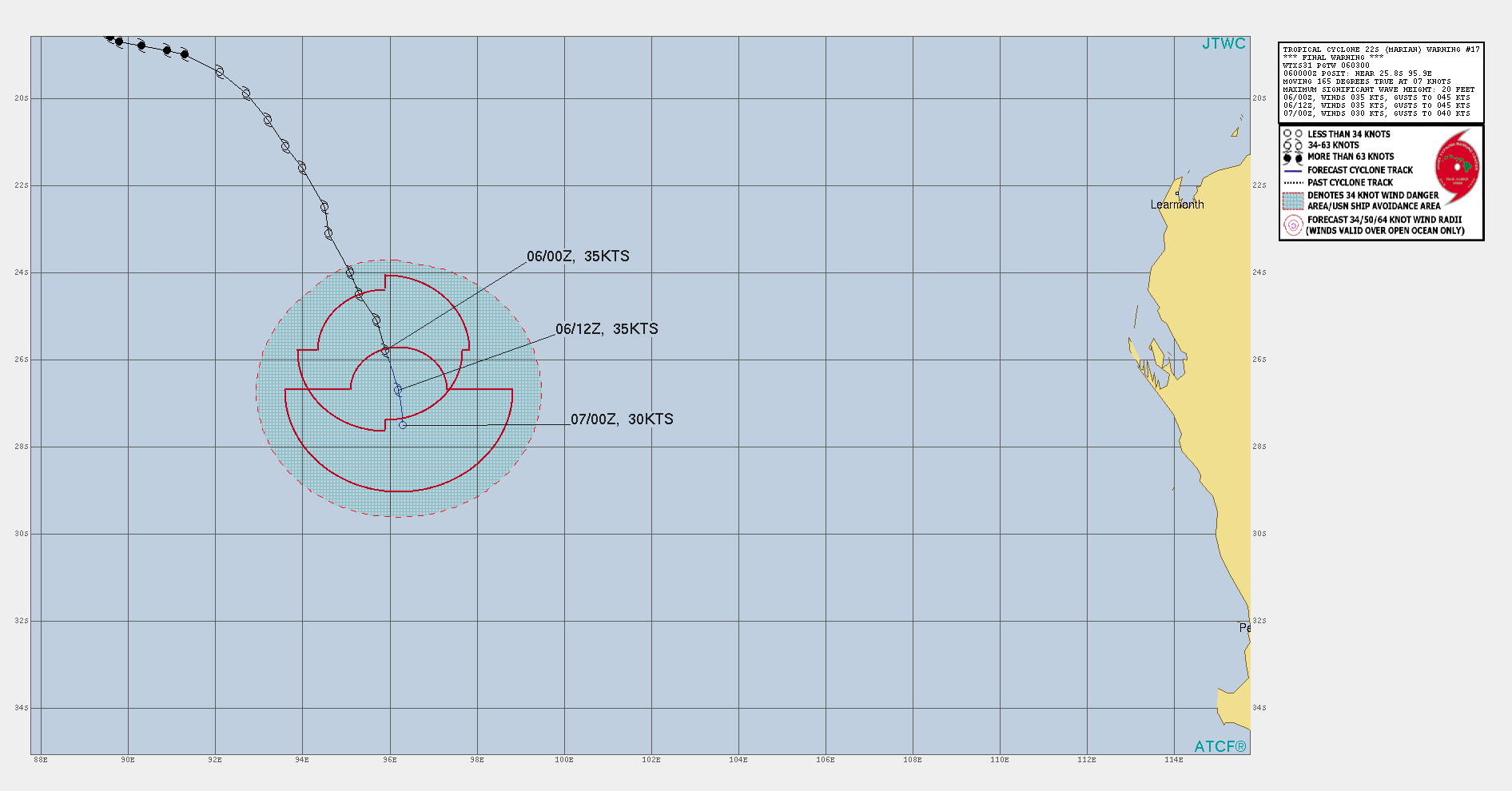
621DFBD3-ECBF-4E91-A3A1-1C9B5326B005.gif
回復

使用道具 舉報

簽到天數: 483 天

[LV.9]以壇為家II

dom|2021-3-6 08:52 | 顯示全部樓層
本帖最後由 dom 於 2021-3-6 09:01 編輯

BoM00Z判定已轉化為Ex
Headline:

Ex-Tropical Cyclone Marian has weakened below tropical cyclone intensity, although it is still producing gales to its west.


Areas affected:

Warning zone: None.

Watch zone: None.

Cancelled zones: None.


Details of Ex-Tropical Cyclone Marian at 8:00 am AWST:

Intensity: tropical low, sustained winds near the centre of 75 kilometres per hour with wind gusts to 100 kilometres per hour.
Location: within 45 kilometres of 25.8 degrees South, 95.6 degrees East , 1520 kilometres south of Cocos Island .
Movement: south southeast at 13 kilometres per hour .

Ex-TC Marian will continue to produce gales to the southwest of its centre during Saturday as it slowly winds down.

No further Information Bulletins or Forecast Track Maps will be issued for this system now that it is below tropical cyclone intensity.
5A4F7C39-37BA-4F1D-8DBF-BF71C23063CA.jpeg 4313039C-6D0F-4141-BA5F-B2C8A021C7A8.gif IDW60280.png

Time (AWST)Intensity CategoryLatitude
(decimal deg.)
Longitude
(decimal deg.)
Estimated Position
Accuracy (km)
0hr8 am March 6tropical low25.8S95.6E45
+6hr2 pm March 6tropical low26.2S95.9E80
+12hr8 pm March 6tropical low26.6S96.3E100
+18hr2 am March 7tropical low26.9S96.3E110
+24hr8 am March 7tropical low27.1S96.2E130
+36hr8 pm March 7tropical low27.6S95.7E160
+48hr8 am March 8tropical low28.3S95.0E200
+60hr8 pm March 8tropical low29.1S95.0E260
+72hr8 am March 9tropical low29.5S94.6E315
回復

使用道具 舉報

簽到天數: 1650 天

[LV.Master]伴壇終老

老農民版夜神月|2021-3-5 13:39 | 顯示全部樓層
DT已降到1.5,FT降至2.0.JTWC預測還能撐36小時,但看起來可能會比較難
TPXS10 PGTW 050303

A. TROPICAL CYCLONE 22S (MARIAN)

B. 05/0230Z

C. 23.34S

D. 94.80E

E. FIVE/HMWRI8

F. T2.0/2.5/W0.5/24HRS  STT: W0.5/03HRS

G. IR/EIR/VIS/MSI

H. REMARKS: 49A/PBO PTLY XPSD LLCC/ANMTN. CNVCTN SHEARED 78NM FROM
LLCC YIELDS A DT OF 1.5. MET AND PT YIELDS 2.0. DBO PT.

I. ADDITIONAL POSITIONS:
   04/2121Z  22.70S  94.83E  SSMS
   04/2346Z  22.95S  94.57E  SSMS


   RHOADES
20210305.0510.himawari-8.vis.22S.MARIAN.45kts.991mb.23.1S.94.6E.100pc.jpg 20210304.2346.f17.91pct91h91v.22S.MARIAN.45kts.991mb.23.1S.94.6E.080pc.jpg
回復

使用道具 舉報

簽到天數: 483 天

[LV.9]以壇為家II

dom|2021-3-4 20:48 | 顯示全部樓層
BoM預測+24H後減弱成低壓
Headline:

Tropical Cyclone Marian is tracking to the south southeast over open waters well to the west of WA mainland.


Areas affected:

Warning zone: None.

Watch zone: None.

Cancelled zones: None.


Details of Tropical Cyclone Marian at 8:00 pm AWST:

Intensity: category 1, sustained winds near the centre of 85 kilometres per hour with wind gusts to 120 kilometres per hour.
Location: within 35 kilometres of 21.7 degrees South, 94.1 degrees East , 1100 kilometres south southwest of Cocos Island .
Movement: southeast at 13 kilometres per hour .

Tropical Cyclone Marian is expected to continue tracking to the south southeast over the central Indian Ocean. The system is likely to weaken below tropical cyclone intensity late Friday or early Saturday.
IDW60280.png
Time (AWST)Intensity CategoryLatitude
(decimal deg.)
Longitude
(decimal deg.)
Estimated Position
Accuracy (km)
0hr8 pm March 4121.7S94.1E35
+6hr2 am March 5122.4S94.5E65
+12hr8 am March 5123.1S95.0E80
+18hr2 pm March 5123.8S95.2E90
+24hr8 pm March 5124.4S95.5E105
+36hr8 am March 6tropical low25.6S95.9E130
+48hr8 pm March 6tropical low26.2S96.3E195
+60hr8 am March 7tropical low26.7S96.3E245
+72hr8 pm March 7tropical low27.2S95.7E305
回復

使用道具 舉報

簽到天數: 1650 天

[LV.Master]伴壇終老

老農民版夜神月|2021-3-4 09:45 | 顯示全部樓層
本帖最後由 老農民版夜神月 於 2021-3-4 11:13 編輯

顯然22S並未如預報暫時停止減弱的步伐
BoM00Z降澳式C1
IDW27600
TROPICAL CYCLONE TECHNICAL BULLETIN: AUSTRALIA - WESTERN REGION
Issued by AUSTRALIAN BUREAU OF METEOROLOGY TROPICAL CYCLONE WARNING CENTRE
at: 0137 UTC 04/03/2021
Name: Tropical Cyclone Marian
Identifier: 15U
Data At: 0000 UTC
Latitude: 20.6S
Longitude: 93.2E
Location Accuracy: within 25 nm [45 km]
Movement Towards: southeast [143 deg]
Speed of Movement: 9 knots [17 km/h]
Maximum 10-Minute Wind: 40 knots [75 km/h]
Maximum 3-Second Wind Gust: 55 knots [100 km/h]
Central Pressure: 990 hPa
Radius of 34-knot winds NE quadrant: 140 nm [260 km]
Radius of 34-knot winds SE quadrant: 140 nm [260 km]
Radius of 34-knot winds SW quadrant: 140 nm [260 km]
Radius of 34-knot winds NW quadrant: 140 nm [260 km]
Radius of 48-knot winds NE quadrant:   
Radius of 48-knot winds SE quadrant:   
Radius of 48-knot winds SW quadrant:   
Radius of 48-knot winds NW quadrant:   
Radius of 64-knot winds:
Radius of Maximum Winds: 40 nm [75 km]
Dvorak Intensity Code: T2.5/3.0/W1.0/24HRS STT:W1.0/12HRS
Pressure of outermost isobar: 1004 hPa
Radius of outermost closed isobar: 250 nm [465 km]
FORECAST DATA
Date/Time    : Location    : Loc. Accuracy: Max Wind   : Central Pressure
[UTC]        : degrees     :      nm  [km]: knots[km/h]: hPa
+06:  04/0600: 21.3S  93.7E:     040 [075]:  040  [075]:  983
+12:  04/1200: 22.0S  94.2E:     050 [090]:  040  [075]:  982
+18:  04/1800: 22.6S  94.6E:     055 [100]:  040  [075]:  984
+24:  05/0000: 23.4S  95.0E:     060 [105]:  040  [075]:  984
+36:  05/1200: 24.7S  95.6E:     070 [125]:  040  [075]:  986
+48:  06/0000: 26.0S  96.0E:     085 [160]:  035  [065]:  989
+60:  06/1200: 26.8S  96.4E:     125 [230]:  035  [065]:  991
+72:  07/0000: 27.5S  96.5E:     160 [295]:  030  [055]:  998
+96:  08/0000: 28.8S  95.0E:     245 [450]:  030  [055]: 1004
+120: 09/0000: 30.2S  95.0E:     295 [545]:  030  [055]: 1007

IDW60280 (17).png ir_lalo-animated (17).gif

回復

使用道具 舉報

簽到天數: 1650 天

[LV.Master]伴壇終老

老農民版夜神月|2021-3-4 02:13 | 顯示全部樓層
本帖最後由 老農民版夜神月 於 2021-3-4 11:12 編輯

BoM在報文中認為強度將持續暫時的固定在50節大約一天,随後回到減弱的大趨勢並消亡
IDW27600
TROPICAL CYCLONE TECHNICAL BULLETIN: AUSTRALIA - WESTERN REGION
Issued by AUSTRALIAN BUREAU OF METEOROLOGY TROPICAL CYCLONE WARNING CENTRE
at: 1804 UTC 03/03/2021
Name: Tropical Cyclone Marian
Identifier: 15U
Data At: 1800 UTC
Latitude: 19.7S
Longitude: 92.8E
Location Accuracy: within 30 nm [55 km]
Movement Towards: east southeast [119 deg]
Speed of Movement: 8 knots [15 km/h]
Maximum 10-Minute Wind: 50 knots [95 km/h]
Maximum 3-Second Wind Gust: 70 knots [130 km/h]
Central Pressure: 984 hPa
Radius of 34-knot winds NE quadrant: 130 nm [240 km]
Radius of 34-knot winds SE quadrant: 160 nm [295 km]
Radius of 34-knot winds SW quadrant: 150 nm [280 km]
Radius of 34-knot winds NW quadrant: 130 nm [240 km]
Radius of 48-knot winds NE quadrant: 70 nm [130 km]
Radius of 48-knot winds SE quadrant: 70 nm [130 km]
Radius of 48-knot winds SW quadrant: 70 nm [130 km]
Radius of 48-knot winds NW quadrant: 70 nm [130 km]
Radius of 64-knot winds:
Radius of Maximum Winds: 30 nm [55 km]
Dvorak Intensity Code: T3.5/3.5/W1.0/24HRS STT:S0.0/6HRS
Pressure of outermost isobar: 1004 hPa
Radius of outermost closed isobar: 300 nm [555 km]
FORECAST DATA
Date/Time    : Location    : Loc. Accuracy: Max Wind   : Central Pressure
[UTC]        : degrees     :      nm  [km]: knots[km/h]: hPa
+06:  04/0000: 20.2S  93.6E:     045 [080]:  050  [095]:  984
+12:  04/0600: 20.7S  94.0E:     050 [090]:  050  [095]:  984
+18:  04/1200: 21.4S  94.5E:     050 [095]:  050  [095]:  984
+24:  04/1800: 22.1S  94.9E:     055 [100]:  045  [085]:  986
+36:  05/0600: 23.5S  95.6E:     060 [110]:  040  [075]:  989
+48:  05/1800: 24.9S  96.1E:     080 [150]:  035  [065]:  993
+60:  06/0600: 26.2S  96.5E:     105 [195]:  035  [065]:  992
+72:  06/1800: 26.9S  96.7E:     145 [270]:  035  [065]:  991
+96:  07/1800: 28.6S  96.4E:     235 [435]:  030  [055]:  995
+120: 08/1800: 30.8S  95.9E:     310 [570]:  030  [055]:  993

IDW60280 (15).png 20210303.1740.himawari-8.ir.22S.MARIAN.50kts.985mb.19.3S.92.1E.100pc.jpg
20210303.1245.f17.91pct91h91v.22S.MARIAN.50kts.985mb.19.3S.92.1E.095pc.jpg
回復

使用道具 舉報

快速回覆
您需要登錄後才可以回帖 登錄 | 立即加入

本版積分規則

dom

    主題

    帖子

    24萬

    積分

    11級[狂風Violent storm]

    Rank: 11Rank: 11Rank: 11Rank: 11

11級[狂風Violent storm]

發訊息

本平台僅供學術討論之用,預報應以氣象局為準

威普網站虛擬主機贊助公司

臺灣第一個天氣類型社群平台 即時天氣資訊、精準颱風動態

線上客服
FB傳送訊息
廣告行銷
精準行銷 物超所值
官方粉專
發佈 快速回復 返回頂部 返回列表