開啟輔助訪問
 找回密碼
 立即加入

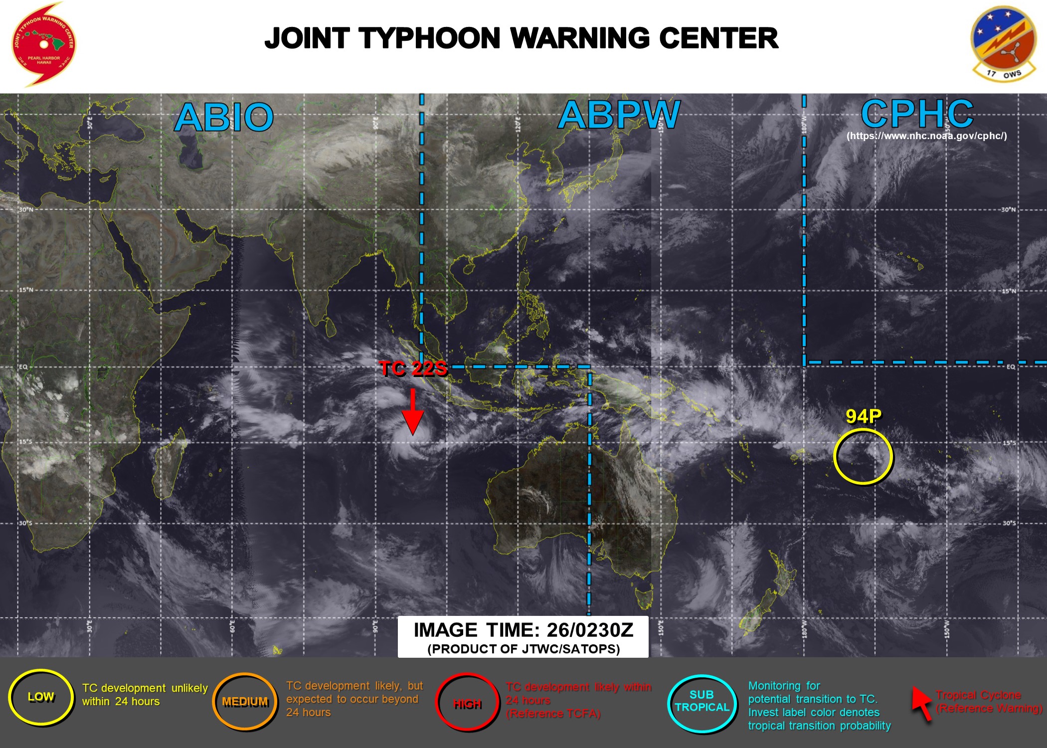
22S.Marian 曾短暫增強至澳式C4 逐漸南下減弱

簽到天數: 483 天

[LV.9]以壇為家II

dom|2021-2-26 14:58 | 顯示全部樓層
BoM命名Marian
Details of Tropical Cyclone Marian at 12:30 pm CCT:

Intensity: category 1, sustained winds near the centre of 75 kilometres per hour with wind gusts to 100 kilometres per hour.
Location: within 45 kilometres of 14.5 degrees South, 98.9 degrees East , 340 kilometres southeast of Cocos Island and 860 kilometres west southwest of Christmas Island .
Movement: west southwest at 31 kilometres per hour .

Tropical Cyclone Marian will continue tracking to the west southwest passing south of Cocos (Keeling) Islands tonight but not having any direct impact upon the islands.

During Saturday it is likely to be moving away from the islands.
IDA00041.png IDW60280.png 螢幕快照 2021-02-26 下午2.57.21.png
回復

使用道具 舉報

簽到天數: 483 天

[LV.9]以壇為家II

dom|2021-2-26 11:07 | 顯示全部樓層
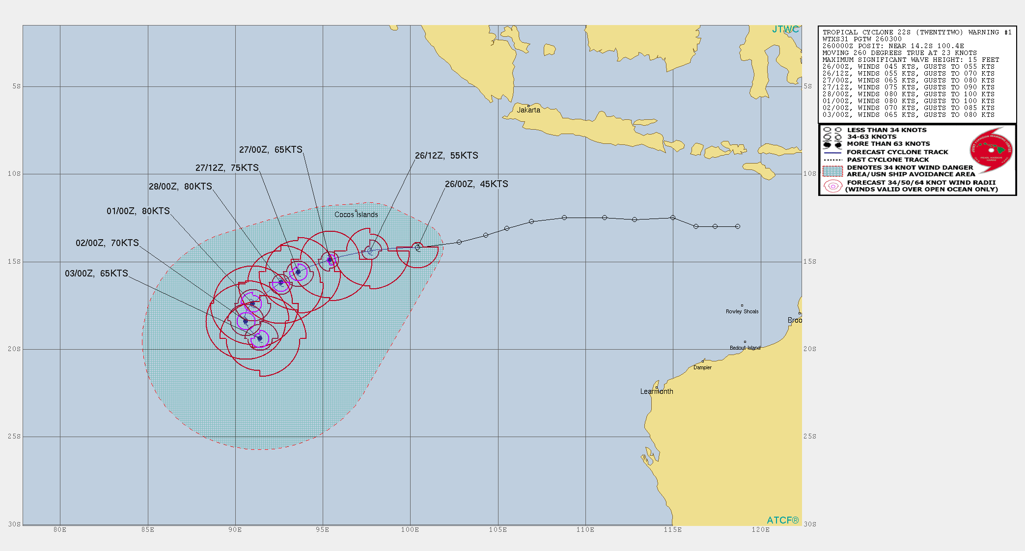
JTWC上修00Z強度至45節,初報上望80節
22S TWENTYTWO 210226 0000 14.2S 100.4E SHEM 45 999
TPXS10 PGTW 260254

A. TROPICAL DEPRESSION 22S (S OF COCOS ISLAND)

B. 26/0220Z

C. 13.91S

D. 99.23E

E. FIVE/MET8

F. T3.0/3.0/D1.5/24HRS STT: D0.5/03HRS

G. IR/EIR/VIS/MSI

H. REMARKS: 40A/PBO SBC/ANMTN. CNVCTN WRAPS .65 ON LOG10 SPIRAL
YIELDING A DT OF 3.0. MET AND PT AT 2.5. DBO DT.

I. ADDITIONAL POSITIONS:
25/2336Z 14.20S 100.47E SSMS


GOODMAN
WTXS31 PGTW 260300
MSGID/GENADMIN/JOINT TYPHOON WRNCEN PEARL HARBOR HI//
SUBJ/TROPICAL CYCLONE 22S (TWENTYTWO) WARNING NR 001//
RMKS/
1. TROPICAL CYCLONE 22S (TWENTYTWO) WARNING NR 001   
   01 ACTIVE TROPICAL CYCLONE IN SOUTHIO
   MAX SUSTAINED WINDS BASED ON ONE-MINUTE AVERAGE
   WIND RADII VALID OVER OPEN WATER ONLY
    ---
   WARNING POSITION:
   260000Z --- NEAR 14.2S 100.4E
     MOVEMENT PAST SIX HOURS - 260 DEGREES AT 23 KTS
     POSITION ACCURATE TO WITHIN 040 NM
     POSITION BASED ON CENTER LOCATED BY SATELLITE
   PRESENT WIND DISTRIBUTION:
   MAX SUSTAINED WINDS - 045 KT, GUSTS 055 KT
   WIND RADII VALID OVER OPEN WATER ONLY
   RADIUS OF 034 KT WINDS - 020 NM NORTHEAST QUADRANT
                            070 NM SOUTHEAST QUADRANT
                            070 NM SOUTHWEST QUADRANT
                            020 NM NORTHWEST QUADRANT
   REPEAT POSIT: 14.2S 100.4E
    ---
   FORECASTS:
   12 HRS, VALID AT:
   261200Z --- 14.4S 97.7E
   MAX SUSTAINED WINDS - 055 KT, GUSTS 070 KT
   WIND RADII VALID OVER OPEN WATER ONLY
   RADIUS OF 050 KT WINDS - 040 NM NORTHEAST QUADRANT
                            030 NM SOUTHEAST QUADRANT
                            030 NM SOUTHWEST QUADRANT
                            020 NM NORTHWEST QUADRANT
   RADIUS OF 034 KT WINDS - 060 NM NORTHEAST QUADRANT
                            130 NM SOUTHEAST QUADRANT
                            120 NM SOUTHWEST QUADRANT
                            080 NM NORTHWEST QUADRANT
   VECTOR TO 24 HR POSIT: 255 DEG/ 11 KTS
    ---
   24 HRS, VALID AT:
   270000Z --- 14.9S 95.4E
   MAX SUSTAINED WINDS - 065 KT, GUSTS 080 KT
   WIND RADII VALID OVER OPEN WATER ONLY
   RADIUS OF 064 KT WINDS - 020 NM NORTHEAST QUADRANT
                            020 NM SOUTHEAST QUADRANT
                            010 NM SOUTHWEST QUADRANT
                            010 NM NORTHWEST QUADRANT
   RADIUS OF 050 KT WINDS - 030 NM NORTHEAST QUADRANT
                            030 NM SOUTHEAST QUADRANT
                            040 NM SOUTHWEST QUADRANT
                            030 NM NORTHWEST QUADRANT
   RADIUS OF 034 KT WINDS - 100 NM NORTHEAST QUADRANT
                            140 NM SOUTHEAST QUADRANT
                            130 NM SOUTHWEST QUADRANT
                            100 NM NORTHWEST QUADRANT
   VECTOR TO 36 HR POSIT: 250 DEG/ 09 KTS
    ---
   36 HRS, VALID AT:
   271200Z --- 15.6S 93.6E
   MAX SUSTAINED WINDS - 075 KT, GUSTS 090 KT
   WIND RADII VALID OVER OPEN WATER ONLY
   RADIUS OF 064 KT WINDS - 030 NM NORTHEAST QUADRANT
                            030 NM SOUTHEAST QUADRANT
                            030 NM SOUTHWEST QUADRANT
                            020 NM NORTHWEST QUADRANT
   RADIUS OF 050 KT WINDS - 040 NM NORTHEAST QUADRANT
                            050 NM SOUTHEAST QUADRANT
                            050 NM SOUTHWEST QUADRANT
                            040 NM NORTHWEST QUADRANT
   RADIUS OF 034 KT WINDS - 120 NM NORTHEAST QUADRANT
                            140 NM SOUTHEAST QUADRANT
                            130 NM SOUTHWEST QUADRANT
                            110 NM NORTHWEST QUADRANT
   VECTOR TO 48 HR POSIT: 240 DEG/ 06 KTS
    ---
   EXTENDED OUTLOOK:
   48 HRS, VALID AT:
   280000Z --- 16.2S 92.6E
   MAX SUSTAINED WINDS - 080 KT, GUSTS 100 KT
   WIND RADII VALID OVER OPEN WATER ONLY
   RADIUS OF 064 KT WINDS - 000 NM NORTHEAST QUADRANT
                            030 NM SOUTHEAST QUADRANT
                            030 NM SOUTHWEST QUADRANT
                            000 NM NORTHWEST QUADRANT
   RADIUS OF 050 KT WINDS - 030 NM NORTHEAST QUADRANT
                            040 NM SOUTHEAST QUADRANT
                            040 NM SOUTHWEST QUADRANT
                            030 NM NORTHWEST QUADRANT
   RADIUS OF 034 KT WINDS - 130 NM NORTHEAST QUADRANT
                            140 NM SOUTHEAST QUADRANT
                            140 NM SOUTHWEST QUADRANT
                            110 NM NORTHWEST QUADRANT
   VECTOR TO 72 HR POSIT: 230 DEG/ 05 KTS
    ---
   72 HRS, VALID AT:
   010000Z --- 17.4S 91.0E
   MAX SUSTAINED WINDS - 080 KT, GUSTS 100 KT
   WIND RADII VALID OVER OPEN WATER ONLY
   RADIUS OF 064 KT WINDS - 030 NM NORTHEAST QUADRANT
                            030 NM SOUTHEAST QUADRANT
                            030 NM SOUTHWEST QUADRANT
                            040 NM NORTHWEST QUADRANT
   RADIUS OF 050 KT WINDS - 050 NM NORTHEAST QUADRANT
                            060 NM SOUTHEAST QUADRANT
                            060 NM SOUTHWEST QUADRANT
                            050 NM NORTHWEST QUADRANT
   RADIUS OF 034 KT WINDS - 130 NM NORTHEAST QUADRANT
                            150 NM SOUTHEAST QUADRANT
                            140 NM SOUTHWEST QUADRANT
                            130 NM NORTHWEST QUADRANT
   VECTOR TO 96 HR POSIT: 200 DEG/ 03 KTS
    ---
   LONG RANGE OUTLOOK:
    ---
   96 HRS, VALID AT:
   020000Z --- 18.4S 90.6E
   MAX SUSTAINED WINDS - 070 KT, GUSTS 085 KT
   WIND RADII VALID OVER OPEN WATER ONLY
   RADIUS OF 064 KT WINDS - 030 NM NORTHEAST QUADRANT
                            030 NM SOUTHEAST QUADRANT
                            030 NM SOUTHWEST QUADRANT
                            030 NM NORTHWEST QUADRANT
   RADIUS OF 050 KT WINDS - 060 NM NORTHEAST QUADRANT
                            050 NM SOUTHEAST QUADRANT
                            050 NM SOUTHWEST QUADRANT
                            060 NM NORTHWEST QUADRANT
   RADIUS OF 034 KT WINDS - 140 NM NORTHEAST QUADRANT
                            130 NM SOUTHEAST QUADRANT
                            130 NM SOUTHWEST QUADRANT
                            130 NM NORTHWEST QUADRANT
   VECTOR TO 120 HR POSIT: 145 DEG/ 03 KTS
    ---
   120 HRS, VALID AT:
   030000Z --- 19.4S 91.4E
   MAX SUSTAINED WINDS - 065 KT, GUSTS 080 KT
   WIND RADII VALID OVER OPEN WATER ONLY
   RADIUS OF 064 KT WINDS - 030 NM NORTHEAST QUADRANT
                            030 NM SOUTHEAST QUADRANT
                            030 NM SOUTHWEST QUADRANT
                            020 NM NORTHWEST QUADRANT
   RADIUS OF 050 KT WINDS - 060 NM NORTHEAST QUADRANT
                            040 NM SOUTHEAST QUADRANT
                            040 NM SOUTHWEST QUADRANT
                            050 NM NORTHWEST QUADRANT
   RADIUS OF 034 KT WINDS - 150 NM NORTHEAST QUADRANT
                            130 NM SOUTHEAST QUADRANT
                            110 NM SOUTHWEST QUADRANT
                            130 NM NORTHWEST QUADRANT
    ---
REMARKS:
260300Z POSITION NEAR 14.2S 99.7E.
26FEB21. TROPICAL CYCLONE 22S (TWENTYTWO), LOCATED APPROXIMATELY
919 NM WEST-NORTHWEST OF LEARMONTH, AUSTRALIA, HAS TRACKED
WESTWARD AT 23 KNOTS OVER THE PAST SIX HOURS. ANIMATED MULTISPECTRAL
SATELLITE IMAGERY (MSI) SHOWS THE SYSTEM HAS RAPIDLY CONSOLIDATED
WITH FORMATIVE BANDS WRAPPING TIGHTER INTO A LOW LEVEL CIRCULATION
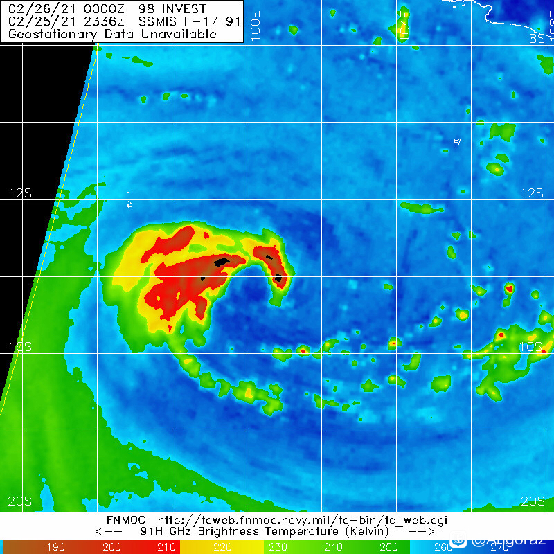
CENTER (LLCC). THE INITIAL POSITION IS BASED ON A 252336Z SSMIS
91GHZ IMAGE, THE ABOVE ANIMATION, AND AMIDST A TIGHT GROUPING
OF AGENCY FIXES. THE INITIAL INTENSITY IS SUPPORTED BY MULTIPLE
DVORAK AGENCY ESTIMATES OF T3.0 (45 KNOTS) FROM PGTW AND APRF. UPPER
LEVEL ANALYSIS INDICATES THE SYSTEM RESIDING EQUATORWARD OF THE
SUBTROPICAL RIDGE (STR), ENVELOPED IN A SMALL REGION OF LOW TO
MODERATE (10-15 KNOTS) VERTICAL WIND SHEAR (VWS) AND WARM SEA
SURFACE TEMPERATURES (28-29C). MODERATE EASTERLY FLOW CONTINUES TO
ENHANCE CONVECTION WEST OF THE LLCC AND OVERALL INTENSIFICATION
PEAKING AT 80 KNOTS NEAR TAU 48. THE CYCLONE WILL CONTINUE TO
PROCEED ON A WEST-SOUTHWESTWARD TRACK AROUND THE STR TO THE SOUTH
THROUGH TAU 72. THEREAFTER, EXPECT THE SYSTEM TO TAKE A MORE
SOUTHERLY TURN AS IT BEGINS TO ROUND THE RIDGE AXIS, THEN MOVE
SOUTHEASTWARD THROUGH THE FORECAST PERIOD. AS THE SYSTEM TURNS TO
THE SOUTHEAST IT WILL ENCOUNTER INCREASING VWS ASSOCIATED WITH THE
MID-LATITUDE WESTERLIES AND BEGIN TO WEAKEN THE SYSTEM AFTER TAU
120. THE NUMERIC GUIDANCE IS IN FAIR AGREEMENT WITH A SPREAD OF 90NM
THROUGH TAU 24, INCREASING TO 280 NM BY TAU 96. DUE TO THE HIGHER
SPREAD IN THE MULTI-MODEL CONSENSUS AT THE LATER TAUS, THERE IS LOW
CONFIDENCE IN THE OVERALL JTWC TRACK FORECAST, WHICH IS LAID
SLIGHTLY RIGHT OF CONSENSUS, FAVORING THE EUROPEAN MODELING GUIDANCE
OVER THE EXTREME LEFT OUTLIER OF NAVGEM. MAXIMUM SIGNIFICANT WAVE
HEIGHT AT 260000Z IS 15 FEET. NEXT WARNINGS AT 261500Z AND 270300Z.//
NNNN
e3587bec54e736d101b35b428c504fc2d46269aa.jpg.gif ac60afc379310a5514eb09bea04543a983261007.jpg abpwsair.jpg
回復

使用道具 舉報

簽到天數: 1650 天

[LV.Master]伴壇終老

老農民版夜神月|2021-2-26 09:54 | 顯示全部樓層
本帖最後由 老農民版夜神月 於 2021-2-27 09:19 編輯

BoM表示該系統在六小時內可能便將獲升格為TC(澳式C1以上)
The low is expected to develop into a tropical cyclone in the next 6 hours.
IDW60280.png #!001_MicrosoftEdge_User_Default_WebNotes_Microsoft-Edge-Web-Notes-Tropical-39604187.jpg
091612j86k487agl7m9l8p.jpg
回復

使用道具 舉報

簽到天數: 1650 天

[LV.Master]伴壇終老

老農民版夜神月|2021-2-26 09:33 | 顯示全部樓層
本帖最後由 老農民版夜神月 於 2021-2-26 09:56 編輯

BoM已將定強上調至35節,但因非是四個象限皆有烈風而暫時未獲命名
IDW27600
TROPICAL CYCLONE TECHNICAL BULLETIN: AUSTRALIA - WESTERN REGION
Issued by AUSTRALIAN BUREAU OF METEOROLOGY TROPICAL CYCLONE WARNING CENTRE
at: 0138 UTC 26/02/2021
Name: Tropical Low  
Identifier: 15U
Data At: 0000 UTC
Latitude: 14.2S
Longitude: 100.5E
Location Accuracy: within 30 nm [55 km]
Movement Towards: west southwest [255 deg]
Speed of Movement: 18 knots [33 km/h]
Maximum 10-Minute Wind: 35 knots [65 km/h]
Maximum 3-Second Wind Gust: 50 knots [95 km/h]
Central Pressure: 995 hPa
Radius of 34-knot winds NE quadrant:   
Radius of 34-knot winds SE quadrant: 150 nm [280 km]
Radius of 34-knot winds SW quadrant: 150 nm [280 km]
Radius of 34-knot winds NW quadrant:   
Radius of 48-knot winds NE quadrant:   
Radius of 48-knot winds SE quadrant:   
Radius of 48-knot winds SW quadrant:   
Radius of 48-knot winds NW quadrant:   
Radius of 64-knot winds:
Radius of Maximum Winds:   
Dvorak Intensity Code: T3.0/3.0/D1.0/24HRS STT: D0.5/06HRS
Pressure of outermost isobar: 1002 hPa
Radius of outermost closed isobar: 200 nm [370 km]
FORECAST DATA
Date/Time    : Location    : Loc. Accuracy: Max Wind   : Central Pressure
[UTC]        : degrees     :      nm  [km]: knots[km/h]: hPa
+06:  26/0600: 14.4S  98.7E:     035 [065]:  040  [075]:  993
+12:  26/1200: 14.6S  97.2E:     040 [075]:  040  [075]:  992
+18:  26/1800: 14.7S  96.0E:     050 [090]:  045  [085]:  989
+24:  27/0000: 14.9S  94.9E:     050 [095]:  050  [095]:  986
+36:  27/1200: 15.7S  93.4E:     065 [125]:  055  [100]:  981
+48:  28/0000: 16.3S  92.2E:     085 [160]:  060  [110]:  977
+60:  28/1200: 16.9S  91.4E:     095 [175]:  065  [120]:  973
+72:  01/0000: 17.4S  90.6E:     110 [205]:  070  [130]:  969
+96:  02/0000: 18.1S  90.0E:     145 [265]:  065  [120]:  970
+120: 03/0000: 18.9S  91.7E:     195 [360]:  055  [100]:  979
REMARKS:
Tropical low 15U continues to develop and is near TC intensity. Deep convection
has developed near the centre overnight with improved convective banding since
22UTC.

Dvorak analysis of 3.0 based upon curved band pattern [0.7 wrap] supported by
MET of 3.0 [D1.0 over 24h]. This is higher than objective NOAA ADT values of
2.4.

The Dvorak rating would normally equate to tropical cyclone intensity and while
the maximum winds are 35 kn, gales are currently estimated only in southern
quadrants and so not extending more than halfway around. This estimation is
based on the 18kn translation speed to the WSW, however if the satellite
signature continues, TC intensity is likely imminent and upcoming scatterometry
should assist in that assessment.

The analysed high shear is being offset by the split flow in the upper levels
from the recent convective burst northeast of the centre so it is expected that
the vortex tilt will reduce permitting further intensification. However the
chance for rapid intensification in the next 24-36h is reduced as the system is
larger than normal owing to the synoptic forcing especially south of the system.
Peak intensity is forecast at 70kn within 72h and maybe sustained for a period
in a marginally favourable environment. Indeed model guidance maintains the
system at TC intensity through the next 5-7 days.

The mid-level ridge to the south continues to dominate the steering with a WSW
motion forecast although on Saturday the motion will slow as the system deepens
and the ridge weakens in response to a developing mid-latitude trough to the
southeast off southern Western Australia. By Tuesday the slow moving system
should track to the southeast and accelerate somewhat owing to an approaching
mid-latitude trough. At this range there is a considerable spread in model
guidance.


Copyright Commonwealth of Australia
==
The next bulletin for this system will be issued by: 26/0730 UTC.

20210226.0120.himawari-8.ir.22S.TWENTYTWO.35kts.996mb.14S.100.8E.100pc.jpg
20210225.2336.f17.91pct91h91v.98S.INVEST.35kts.996mb.14S.100.8E.095pc.jpg 20210225.2336.f17.91h.98S.INVEST.35kts.996mb.14S.100.8E.095pc.jpg
回復

使用道具 舉報

簽到天數: 483 天

[LV.9]以壇為家II

dom|2021-2-26 08:57 來自手機 | 顯示全部樓層
本帖最後由 dom 於 2021-2-26 09:04 編輯

JTWC00Z升格22S
22S TWENTYTWO 210226 0000 14.0S 100.8E SHEM 35 996
IMG_2969.JPG
回復

使用道具 舉報

簽到天數: 1650 天

[LV.Master]伴壇終老

老農民版夜神月|2021-2-26 05:49 | 顯示全部樓層
JTWC提高定強至30節,風場掃出其系統東南側有大片30KT風旗
LATEST.jpg 20210225.2110.himawari-8.ir.98S.INVEST.30kts.999mb.13.9S.102.8E.100pc.jpg
20210225.1849.n20.165bt.98S.INVEST.30kts.999mb.13.9S.102.8E.075pc.jpg 98S_gefs_latest.png

回復

使用道具 舉報

簽到天數: 1650 天

[LV.Master]伴壇終老

老農民版夜神月|2021-2-25 18:02 | 顯示全部樓層
BoM上望+96H後70節
IDW27600
TROPICAL CYCLONE TECHNICAL BULLETIN: AUSTRALIA - WESTERN REGION
Issued by AUSTRALIAN BUREAU OF METEOROLOGY TROPICAL CYCLONE WARNING CENTRE
at: 0728 UTC 25/02/2021
Name: Tropical Low  
Identifier: 15U
Data At: 0600 UTC
Latitude: 13.1S
Longitude: 105.8E
Location Accuracy: within 25 nm [45 km]
Movement Towards: west southwest [247 deg]
Speed of Movement: 12 knots [22 km/h]
Maximum 10-Minute Wind: 30 knots [55 km/h]
Maximum 3-Second Wind Gust: 45 knots [85 km/h]
Central Pressure: 997 hPa
Radius of 34-knot winds NE quadrant:   
Radius of 34-knot winds SE quadrant:   
Radius of 34-knot winds SW quadrant:   
Radius of 34-knot winds NW quadrant:   
Radius of 48-knot winds NE quadrant:   
Radius of 48-knot winds SE quadrant:   
Radius of 48-knot winds SW quadrant:   
Radius of 48-knot winds NW quadrant:   
Radius of 64-knot winds:
Radius of Maximum Winds:   
Dvorak Intensity Code: T2.0/2.0/D0.5/24HRS STT:S0.0/6HRS
Pressure of outermost isobar: 1002 hPa
Radius of outermost closed isobar: 180 nm [335 km]
FORECAST DATA
Date/Time    : Location    : Loc. Accuracy: Max Wind   : Central Pressure
[UTC]        : degrees     :      nm  [km]: knots[km/h]: hPa
+06:  25/1200: 13.6S 104.4E:     040 [075]:  030  [055]:  998
+12:  25/1800: 14.0S 102.8E:     060 [110]:  035  [065]:  994
+18:  26/0000: 14.5S 101.2E:     065 [120]:  035  [065]:  995
+24:  26/0600: 14.6S  99.4E:     070 [135]:  040  [075]:  993
+36:  26/1800: 14.8S  96.6E:     090 [165]:  045  [085]:  989
+48:  27/0600: 15.5S  94.7E:     100 [185]:  050  [095]:  985
+60:  27/1800: 16.2S  93.4E:     120 [220]:  055  [100]:  981
+72:  28/0600: 16.9S  92.6E:     130 [245]:  065  [120]:  973
+96:  01/0600: 17.9S  91.3E:     185 [340]:  070  [130]:  969
+120: 02/0600: 18.6S  91.1E:     245 [450]:  060  [110]:  974
REMARKS:
Tropical low 15U is gradually consolidating although still somewhat constrained
by ongoing easterly wind shear. Visible imagery shows a better defined
circulation with a more definitive convective banding to the west.

Dvorak analysis of 2.0 based upon curved band pattern 0.3-0.4 - DT of 2.0-2.5
,and a slight 24h development to indicate a MET of 2.0. Intensity of 30kn is
higher than Dvorak based upon synoptic forcing in convective bands both
northeast and southwest of the centre as indicated by SCATSAT at 0118UTC.

Gales are forecast to begin in the ESE flow on the southern side within 12-24h
with gales likely to extend to northern quadrants in the 24-36 time frame.

The combined synoptic influences of the monsoonal flow and the sub-tropical
ridge to the south will assist in developing a larger circulation than is
typical for this region. Being a large system it may also take a little longer
than normal to intensify further reducing the chance of rapid intensification
within the next 72 hours. Model guidance does sustain the system through 5 to 7
days in a marginally favourable environment until eventually it moves over
cooler waters.

The mid-level ridge to the south is expected to dominate the steering for a
steady WSW motion through into Saturday [+48]. From then a developing
mid-latitude trough is expected to erode the ridge and slow the system. The
prevailing monsoonal NW flow will assist in a more southerly track. In the
longer term there is higher uncertainty - a slow drift south or southwest over
cooler waters contrasts with a potential recurvature to the southeast as the
mid-latitude trough amplifies off the western Australian coast. Even in this
scenario the track should remain west of the Australian mainland.

Copyright Commonwealth of Australia
==
The next bulletin for this system will be issued by: 25/1330 UTC.
20210225.0930.himawari-8.vis.98S.INVEST.25kts.1003mb.13.1S.105.5E.100pc.jpg 98S_gefs_latest (4).png
回復

使用道具 舉報

簽到天數: 483 天

[LV.9]以壇為家II

dom|2021-2-25 17:08 | 顯示全部樓層
BoM預測+24h命名,調高上望至澳式C3
Headline:

A developing tropical low (15U) may cause a period of gales and heavy rain on Cocos (Keeling) Islands overnight Friday into Saturday.


Areas affected:

Warning zone: None.

Watch zone: the Cocos Islands.

Cancelled zones: None.


Details of Tropical Low at 12:30 pm CCT:

Intensity: tropical low, sustained winds near the centre of 55 kilometres per hour with wind gusts to 85 kilometres per hour.
Location: within 45 kilometres of 13.1 degrees South, 105.8 degrees East , 980 kilometres east of Cocos Island and 295 kilometres south of Christmas Island .
Movement: west southwest at 22 kilometres per hour .

Tropical low (15U) is moving steadily to the west southwest and is expected to gradually strengthen. It is forecast to develop into a tropical cyclone on Friday and pass south of Cocos (Keeling) Islands overnight Friday night. The risk of gales and heavy rain increases if the system moves closer to the islands further north than the forecast track indicates.

During Saturday it is likely to be moving away from the islands.


Hazards:

GALES may develop over Cocos (Keeling) Islands for a period from Friday night into Saturday. Strong northwesterly winds are expected to result in choppy seas in the lagoon overnight Friday night and on Saturday.

A period of heavy rainfall is possible over the Cocos (Keeling) Islands from late Friday and on Saturday.


Recommended Action:

The Australian Federal Police advise that there are no community alerts at present.
Communities on Home and West Islands should listen for the next advice.
IDA00041.png IDW60280.png 螢幕快照 2021-02-25 下午5.06.34.png
回復

使用道具 舉報

快速回覆
您需要登錄後才可以回帖 登錄 | 立即加入

本版積分規則

本平台僅供學術討論之用,預報應以氣象局為準

威普網站虛擬主機贊助公司

臺灣第一個天氣類型社群平台 即時天氣資訊、精準颱風動態

線上客服
FB傳送訊息
廣告行銷
精準行銷 物超所值
官方粉專
發佈 快速回復 返回頂部 返回列表