開啟輔助訪問
 找回密碼
 立即加入

13L.Mindy 近岸命名 登陸美國佛州 轉化溫氣

簽到天數: 1650 天

[LV.Master]伴壇終老

2021-9-1 06:25 | 顯示全部樓層
  熱帶風暴  
編號:13 L
名稱:Mindy
024532hr6500qo00pg8b6s.jpg
  基本資料  
擾動編號日期:2021 09 01 06
命名日期  :2021 09 09 06
撤編日期  :2021 09 10 08
登陸地點  :美國-佛羅里達州


  巔峰時期資料  
近中心最強風速 :35  kt (
TS )
海平面最低氣壓 :1004 百帕

  擾動編號資料  

91L.INVEST.15kts.1011mb.13N.20W
20210831.2200.goes-16.ir.91L.INVEST.15kts.1011mb.13N.20W.100pc.jpg 以上資料來自:NHC、颱風論壇整理製作

點評

定位資料貼成90L,麻煩修正~  發表於 2021-9-1 08:16

評分

參與人數 1水氣能量 +15 +1 收起 理由
t02436 + 15 + 1

查看全部評分

回復

使用道具 舉報

簽到天數: 1650 天

[LV.Master]伴壇終老

老農民版夜神月|2021-9-10 13:27 | 顯示全部樓層
本帖最後由 老農民版夜神月 於 2021-9-10 13:59 編輯

升格不過一天半,已變性成為溫帶氣旋 13L_BAND01.gif 024639_5day_cone_no_line_and_wind.png

483
WTNT43 KNHC 100248
TCDAT3

Post-Tropical Cyclone Mindy Discussion Number   6
NWS National Hurricane Center Miami FL       AL132021
1100 PM EDT Thu Sep 09 2021

The structure of Mindy this evening has become quite diffuse, with a
linear band of convection mostly associated with a prominent outflow
boundary emanating away from the system. The last-light visible
low-level cloud motions gave the impression that Mindy was opening
up into a trough, with southwesterly flow ahead and northeasterly
flow immediately behind the estimated center. Indeed, a ASCAT-A pass
valid at 0002 UTC suggested that Mindy no longer has closed cyclonic
flow on its northeast side, with a lack of easterly wind vectors in
this sector of the system. In addition, a rapidly advancing frontal
boundary has already moved off of the Carolina coast and will
soon be merging with the leftover vort-max associated with Mindy.
The accumulation of all this evidence indicates that Mindy no
longer meets the definition of a tropical cyclone, and this will be
the final advisory on the system.

The post-tropical remains of Mindy have continued to accelerate to
the east-northeast this evening at 070/25 kt, moving almost as
quickly as the the maximum sustained winds, which is another reason
why the circulation is likely no longer closed. This motion should
continue for the next 12-24 hours with a gradual slowdown until what
remains of the circulation becomes indistinguishable from the
frontal boundary it is becoming embedded in.


FORECAST POSITIONS AND MAX WINDS

INIT  10/0300Z 32.5N  75.0W   30 KT  35 MPH...POST-TROP/EXTRATROP
12H  10/1200Z 33.2N  71.6W   25 KT  30 MPH...POST-TROP/EXTRATROP
24H  11/0000Z 34.1N  67.8W   25 KT  30 MPH...POST-TROP/EXTRATROP
36H  11/1200Z...DISSIPATED

$$
Forecaster Papin

回復

使用道具 舉報

簽到天數: 1650 天

[LV.Master]伴壇終老

老農民版夜神月|2021-9-10 02:47 | 顯示全部樓層
已於稍早前出海,將持續向東移動並逐漸消散

20210909.1820.goes-16.vis.2km.13L.MINDY.30kts.1005mb.31.7N.79.4W.pc.jpg 20210909.1542.mtb.ASCAT.wind.13L.MINDY.30kts-1005mb.312N.818W.25km.noqc.jpg

FORECAST POSITIONS AND MAX WINDS

INIT  09/1500Z 31.5N  80.7W   30 KT  35 MPH
12H  10/0000Z 32.5N  77.5W   30 KT  35 MPH
24H  10/1200Z 33.6N  73.4W   30 KT  35 MPH
36H  11/0000Z 34.3N  70.3W   25 KT  30 MPH...POST-TROPICAL
48H  11/1200Z...DISSIPATED

145414_5day_cone_no_line_and_wind.png
回復

使用道具 舉報

簽到天數: 1650 天

[LV.Master]伴壇終老

老農民版夜神月|2021-9-9 06:22 | 顯示全部樓層
NHC升格13L,命名Mindy
即將登陸佛羅里達州
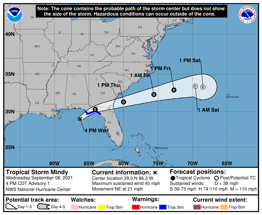
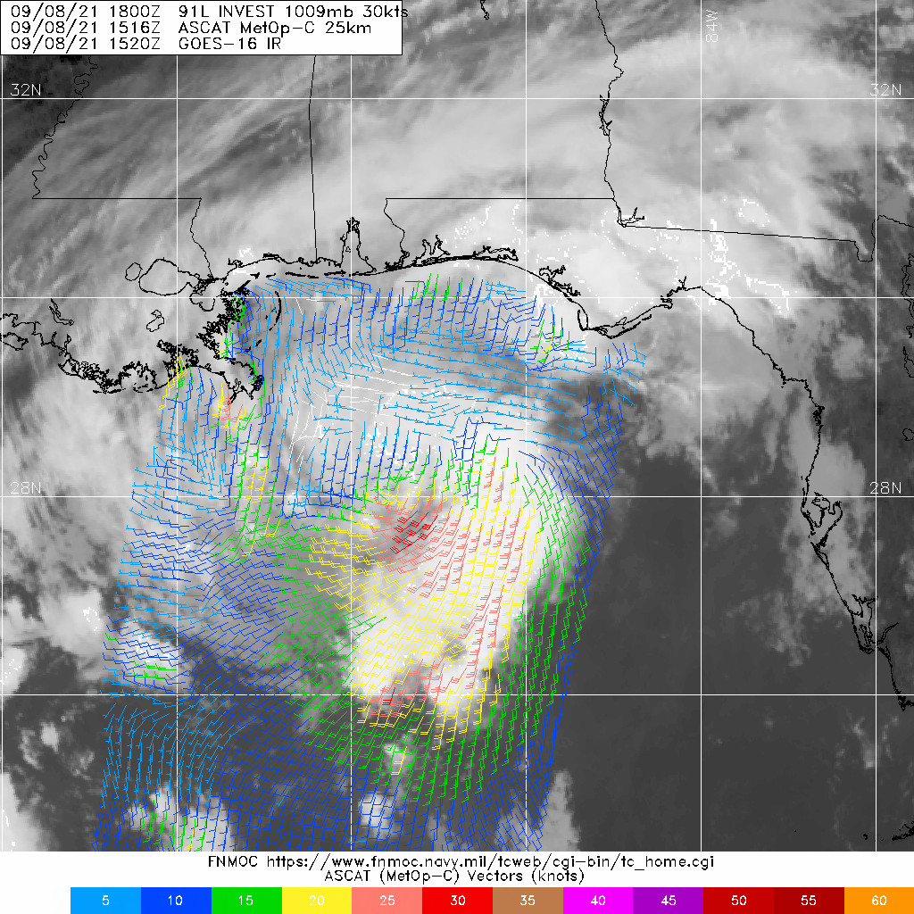
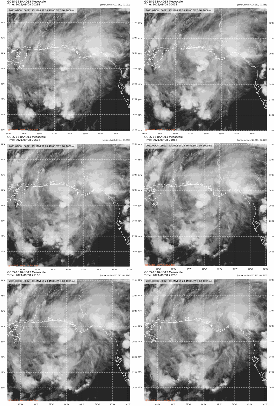
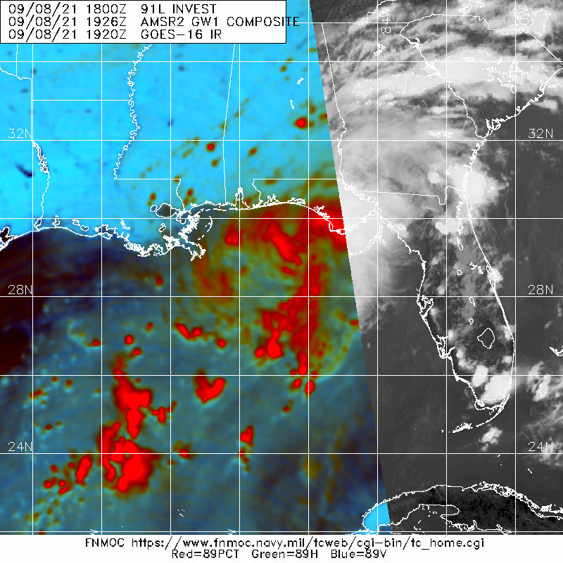
205724_5day_cone_no_line_and_wind.png 20210908.1516.mtc.ASCAT.wind.91L.INVEST.30kts-1009mb.284N.868W.25km.noqc.jpg
91L_BAND13.gif 20210908.1926.gw1.89pct89h89v.91L.INVEST.30kts.1009mb.28.4N.86.8W.63pc.jpg

428
WTNT43 KNHC 082102
TCDAT3

Tropical Storm Mindy Discussion Number   1
NWS National Hurricane Center Miami FL       AL132021
400 PM CDT Wed Sep 08 2021

Through the day, the area of disturbed weather in the northeastern
Gulf of Mexico has gradually become better organized on
geostationary satellite and Doppler radar imagery. Earlier, a 1515
UTC ASCAT-C pass found a number of southwesterly wind retrievals in
the 30-kt range on the southeast side of the formative circulation.
The ASCAT-C Ambiguities at that time also hinted that a very small
closed circulation was trying to develop along the edge of these
stronger winds. Since that time, a well-defined circulation become
evident on KEVX Doppler-radar with inbound velocities occasionally
nearing 40-45 kt to the southeast of the radar center. These
Doppler-radar winds have been increasing over the past couple of
hours as the center moves closer to the radar and I am reasonably
confident this circulation is now surface based. Just in the last
hour or so, NOAA buoy 42039 reported a peak 1-minute sustained wind
of 35 kt just southeast of the center, confirming the system now has
tropical storm force winds. Thus, advisories are being initiated
on tropical storm Mindy with maximum sustained wind of 35 kt.

The most recent estimated motion following the center on radar is to
the northeast at 050/18 kt. The track guidance is in good agreement
that this quick motion should continue with a gentle shift to the
east-northeast in the next 24-36 hours as the system is under the
influence of a deep-layer mid-latitude trough moving across the
eastern United States. On the current heading, the center of
Mindy should move inland over the Florida Panhandle in the next 6-12
hours and then already be offshore of the southeastern United States
by 24 hours. A gradual slowdown is expected thereafter as the
cyclone is left behind by this mid-latitude trough and also becomes
vertically shallow.

Little intensification is expected prior to landfall, with land
interaction resulting in Mindy weakening back to a depression by 24
hours. Conditions do not appear favorable for restrengthening off
the southeastern United States as shear is forecast to increase
above 30 knots in 24 hours. This shear will likely strip away from
remaining convection, and both the ECMWF and GFS simulated IR
brightness temperatures suggest Mindy should become a remnant low in
the day 2-3 period. This remnant low is forecast to open up into a
trough shortly thereafter.

Key Messages:

1. Mindy is expected to produce heavy rainfall from the Florida
Panhandle into southern portions of Georgia and South Carolina
through Thursday morning. This rainfall may produce isolated to
scattered flash, urban, and small stream flooding.

2. Tropical storm conditions are expected through tonight in
portions of the Florida Panhandle where a Tropical Storm Warning is
in effect.

FORECAST POSITIONS AND MAX WINDS

INIT  08/2100Z 29.0N  86.3W   35 KT  40 MPH
12H  09/0600Z 30.3N  84.1W   35 KT  40 MPH...INLAND
24H  09/1800Z 31.3N  80.0W   30 KT  35 MPH...OVER WATER
36H  10/0600Z 32.3N  75.6W   30 KT  35 MPH
48H  10/1800Z 32.9N  72.7W   30 KT  35 MPH
60H  11/0600Z 33.4N  69.6W   25 KT  30 MPH...POST-TROP/REMNT LOW
72H  11/1800Z 33.3N  68.5W   25 KT  30 MPH...POST-TROP/REMNT LOW
96H  12/1800Z...DISSIPATED

$$
Forecaster Papin
回復

使用道具 舉報

簽到天數: 1650 天

[LV.Master]伴壇終老

老農民版夜神月|2021-9-8 08:12 | 顯示全部樓層
逐漸開始發展,NHC一舉提升至Medium,50% 91L_BAND01.gif

two_atl_2d1 (41).png two_atl_5d1 (42).png

1. Showers and thunderstorms have increased somewhat this evening over
the south-central Gulf of Mexico in association with a surface
trough and an upper-level disturbance.  The system is expected to
move slowly northeastward over the central and northeastern Gulf of
Mexico during the next couple of days.  Upper-level winds are
currently only marginally conducive for development, but they are
forecast to become slightly more favorable by late Wednesday, and a
tropical or subtropical depression could form as the system nears
the northern Gulf coast Wednesday night or Thursday.  The
disturbance is then expected to cross the southeastern United
States, and some slight additional development will be possible
after it emerges off the southeastern United States coast late this
week.  Regardless of development, areas of heavy rainfall will be
possible across portions of the Florida panhandle and southern
Georgia on Wednesday and Thursday, with localized flooding possible.
* Formation chance through 48 hours...medium...50 percent.
* Formation chance through 5 days...medium...50 percent.
回復

使用道具 舉報

簽到天數: 1650 天

[LV.Master]伴壇終老

老農民版夜神月|2021-9-5 08:19 | 顯示全部樓層
後期或將於美國近岸發展
two_atl_5d1 (40).png gfs_mslp_pcpn_frzn_seus_12.png
gfs_mslp_pcpn_frzn_seus_16.png gfs_mslp_pcpn_frzn_seus_20.png
回復

使用道具 舉報

簽到天數: 1650 天

[LV.Master]伴壇終老

老農民版夜神月|2021-9-4 03:54 | 顯示全部樓層
NHC展望0%/30%,預測後期有望移入墨西哥灣發展
1. A surface trough over portions of Central America and the
southern Yucatan Peninsula of Mexico is producing disorganized
shower and thunderstorm activity.  This system is expected to move
west-northwestward during the next day or two, bringing locally
heavy rains to these areas.  The disturbance is expected to move
over the southwestern Gulf of Mexico late this weekend, and then
move northwestward to northward over the western Gulf of Mexico
early next week.  However, unfavorable upper-level winds could limit
significant development during that time.  
* Formation chance through 48 hours...low...near 0 percent.
* Formation chance through 5 days...low...30 percent.

two_atl_2d1 (39).png two_atl_5d1 (39).png
91L_gefs_latest (2).png
回復

使用道具 舉報

簽到天數: 1650 天

[LV.Master]伴壇終老

老農民版夜神月|2021-9-3 07:41 | 顯示全部樓層
NHC展望維持10%/20%
1. A small area of low pressure and associated surface trough over
eastern Honduras is producing disorganized shower and thunderstorm
activity over portions of the western Caribbean Sea.  A portion of
the low's circulation could move over the Gulf of Honduras on
Friday.  However, development there, if any, is expected to be slow
to occur. This system could then move over the southwestern Gulf of
Mexico during the weekend, but by then unfavorable upper-level winds
are likely to limit significant development early next week while
the system moves northwestward or northward over the western Gulf
of Mexico.  Regardless of development, heavy rains are possible
across portions of Central America and the Yucatan Peninsula through
the weekend.
* Formation chance through 48 hours...low...10 percent.
* Formation chance through 5 days...low...20 percent.
two_atl_2d1 (38).png two_atl_5d1 (38).png
sfcplot_91L_latest.png
回復

使用道具 舉報

12下一頁
快速回覆
您需要登錄後才可以回帖 登錄 | 立即加入

本版積分規則

本平台僅供學術討論之用,預報應以氣象局為準

威普網站虛擬主機贊助公司

臺灣第一個天氣類型社群平台 即時天氣資訊、精準颱風動態

線上客服
FB傳送訊息
廣告行銷
精準行銷 物超所值
官方粉專
發佈 快速回復 返回頂部 返回列表