開啟輔助訪問
 找回密碼
 立即加入

01E 登陸墨西哥南部 隨即消散無緣命名

簽到天數: 260 天

[LV.8]以壇為家I

2016-6-6 00:12 | 顯示全部樓層
  熱帶低壓  
編號:01 E
名稱:
image-download.jpg

  基本資料  
擾動編號日期:2016 06 05 20
命名日期  :2016 06 07 04
撤編日期  :2016 06 09 12
登陸地點  :墨西哥 瓦哈卡州 特萬特佩克海灣

  巔峰時期資料  
近中心最強風速 :30  kt ( TD )
海平面最低氣壓 :1006 百帕

  過去路徑圖  
TWTYBBS_01E_UNNAMED_TRACK_t02436_TWTYBBS.jpg

  討論帖圖片  
92E.INVEST.25kts.1007mb.10.9N 100.5W

20160605.1545.goes13.x.ir1km_bw.92EINVEST.25kts-1007mb-109N-1005W.100pc.jpg

NHC:20%

2. Disorganized showers and thunderstorms associated with an elongated
area of low pressure are centered several hundred miles south of
Acapulco, Mexico. Some gradual development of this system is
possible during the next few days while it moves slowly
northeastward. Regardless of development, locally heavy rains are
likely later today through Tuesday over portions of southern Mexico
and Guatemala.
* Formation chance through 48 hours...low...20 percent
* Formation chance through 5 days...low...30 percent two_pac_2d2.png

以上資料來自:NHC、颱風論壇整理製作

評分

參與人數 1水氣能量 +15 +1 收起 理由
t02436 + 15 + 1

查看全部評分

回復

使用道具 舉報

簽到天數: 260 天

[LV.8]以壇為家I

tpm630|2016-6-7 00:18 | 顯示全部樓層
結構緊縮 渦度提升 OHC支持
但北側風切影響下發展受限 NHC等機構都暫不支持
未來持續趨向墨國南部省分沿海
92E_gefs_latest.png

20160606.1334.f18.91h.92E.INVEST.25kts.1007mb.13.5N.98.5W.93pc.jpg


rbtop_lalo-animated.gif


回復

使用道具 舉報

簽到天數: 85 天

[LV.6]常住居民II

陳約禮@FB|2016-6-7 09:58 | 顯示全部樓層

NHC升格01E,成為今年東北太平洋颶風季首個熱帶氣旋
000
WTPZ41 KNHC 062034
TCDEP1

TROPICAL DEPRESSION ONE-E DISCUSSION NUMBER   1
NWS NATIONAL HURRICANE CENTER MIAMI FL       EP012016
400 PM CDT MON JUN 06 2016

The compact area of low pressure near the coast of southern Mexico
has developed a well-defined center of circulation and sufficiently
organized deep convection to be classified a tropical depression,
the first one of the 2016 eastern North Pacific hurricane season.
The initial intensity estimate of 30 kt is based on a pair of
recent ASCAT passes and Dvorak classifications from TAFB and SAB.
The depression is a sheared tropical cyclone with much of the
associated deep convection located to the north of the low-level
center.  Since the wind shear is expected to remain high, no
change in strength is predicted before the depression reaches the
coast on Tuesday.

The system is moving northeastward at about 6 kt on the east
side of a broad trough that extends southwestward from the Gulf of
Mexico.  A continued northeastward motion at about the same forward
speed is expected, bringing the center near the coast in about 24
hours. However, since the vortex is strongly tilted, the mid-level
center of the system will likely move inland as early as tonight.

The main hazard from the depression is the potential for heavy
rainfall, which has already begun over portions of southern
Mexico.  These rains could cause life-threatening flash floods and
mud slides, especially in areas of high terrain.

The Government of Mexico has issued a tropical storm watch for a
portion of southern Mexico.

FORECAST POSITIONS AND MAX WINDS

INIT  06/2100Z 14.2N  97.0W   30 KT  35 MPH
12H  07/0600Z 15.1N  96.3W   30 KT  35 MPH
24H  07/1800Z 15.9N  95.1W   30 KT  35 MPH
36H  08/0600Z 16.5N  94.0W   20 KT  25 MPH...INLAND
48H  08/1800Z...DISSIPATED
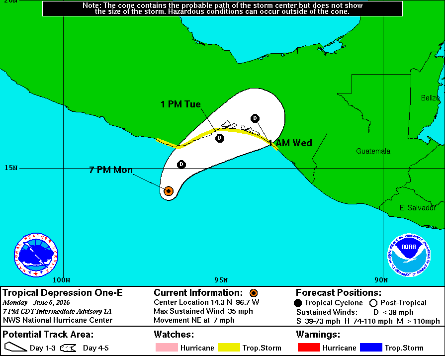
$$
Forecaster Cangialosi
預測一天後登陸,各數值及NHC皆不看好命名
234922W5_NL_sm.gif

01E_intensity_latest.png
由於風切偏強,深對流中心及LLCC並未重合
rgb-animated.gif


評分

參與人數 1水氣能量 +5 收起 理由
tpm630 + 5 感謝支持,太有默契

查看全部評分

回復

使用道具 舉報

簽到天數: 260 天

[LV.8]以壇為家I

tpm630|2016-6-7 10:01 | 顯示全部樓層
本帖最後由 tpm630 於 2016-6-7 10:04 編輯

NHC 編號升格01E 巔峰維持30KT
風切持續影響 不支持發展 2天後登陸墨西哥南部消散
TROPICAL DEPRESSION ONE-E DISCUSSION NUMBER   1
NWS NATIONAL HURRICANE CENTER MIAMI FL       EP012016
400 PM CDT MON JUN 06 2016

The compact area of low pressure near the coast of southern Mexico
has developed a well-defined center of circulation and sufficiently
organized deep convection to be classified a tropical depression,
the first one of the 2016 eastern North Pacific hurricane season.
The initial intensity estimate of 30 kt is based on a pair of
recent ASCAT passes and Dvorak classifications from TAFB and SAB.
The depression is a sheared tropical cyclone with much of the
associated deep convection located to the north of the low-level
center.  Since the wind shear is expected to remain high, no
change in strength is predicted before the depression reaches the
coast on Tuesday.

The system is moving northeastward at about 6 kt on the east
side of a broad trough that extends southwestward from the Gulf of
Mexico.  A continued northeastward motion at about the same forward
speed is expected, bringing the center near the coast in about 24
hours. However, since the vortex is strongly tilted, the mid-level
center of the system will likely move inland as early as tonight.

The main hazard from the depression is the potential for heavy
rainfall, which has already begun over portions of southern
Mexico.  These rains could cause life-threatening flash floods and
mud slides, especially in areas of high terrain.

The Government of Mexico has issued a tropical storm watch for a
portion of southern Mexico.

FORECAST POSITIONS AND MAX WINDS

INIT  06/2100Z 14.2N  97.0W   30 KT  35 MPH
12H  07/0600Z 15.1N  96.3W   30 KT  35 MPH
24H  07/1800Z 15.9N  95.1W   30 KT  35 MPH
36H  08/0600Z 16.5N  94.0W   20 KT  25 MPH...INLAND
48H  08/1800Z...DISSIPATED
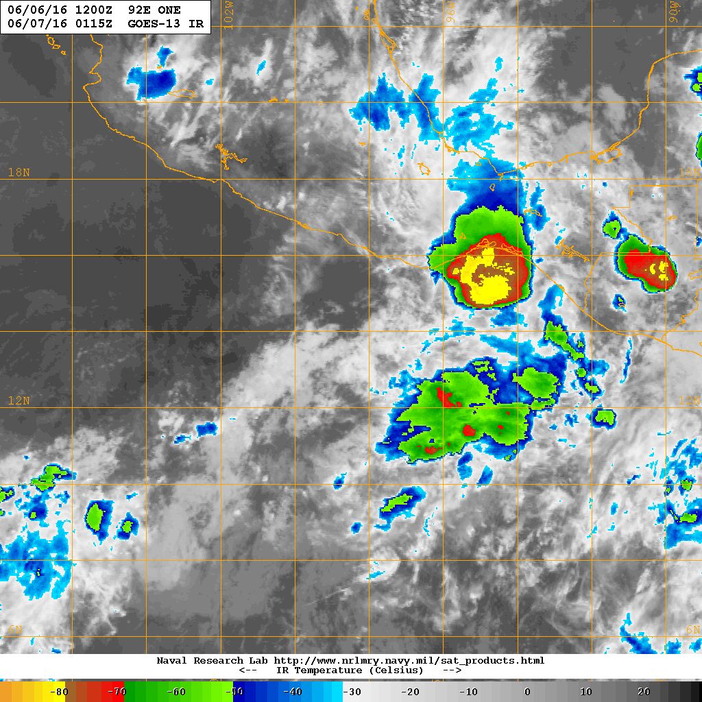
234922W5_NL_sm.gif


20160607.0115.goes13.x.ir1km.92EONE.25kts-1007mb-135N-985W.100pc.jpg


回復

使用道具 舉報

簽到天數: 260 天

[LV.8]以壇為家I

tpm630|2016-6-8 22:56 | 顯示全部樓層
已登陸墨西哥 瓦哈卡州 特萬特佩克海灣(Gulf of Tehuantepec) 登陸即消散
143648W_NL_sm.gif


000
WTPZ41 KNHC 081434
TCDEP1

REMNANTS OF ONE-E DISCUSSION NUMBER   8
NWS NATIONAL HURRICANE CENTER MIAMI FL       EP012016
1000 AM CDT WED JUN 08 2016

Mexican surface and radar data, along with a recent RAPIDSCAT
scatterometer overpass, indicate that the tropical depression
reached the Mexican coast earlier this morning and the surface
circulation has now dissipated. Peak onshore winds continue at
about 20 kt, which should diminish later today.

Even though the surface circulation has dissipated, there is a
continued heavy rainfall threat from this system. This rainfall will
be enhanced by the moist southwest flow over the high terrain of
southern Mexico and western Guatemala, where flash floods and mud
slides are anticipated.

FORECAST POSITIONS AND MAX WINDS

INIT  08/1500Z 16.4N  94.8W   20 KT  25 MPH...REMNANTS OF ONE-E
12H  09/0000Z...DISSIPATED

$$
Forecaster Landsea
殘餘對流伴隨著西南風,仍可能為南墨西哥與瓜地馬拉西部帶來災情

rbtop_lalo-animated.gif


評分

參與人數 1水氣能量 +10 收起 理由
blackcat + 10

查看全部評分

回復

使用道具 舉報

快速回覆
您需要登錄後才可以回帖 登錄 | 立即加入

本版積分規則

本平台僅供學術討論之用,預報應以氣象局為準

威普網站虛擬主機贊助公司

臺灣第一個天氣類型社群平台 即時天氣資訊、精準颱風動態

線上客服
FB傳送訊息
廣告行銷
精準行銷 物超所值
官方粉專
發佈 快速回復 返回頂部 返回列表