開啟輔助訪問
 找回密碼
 立即加入

02E.Agatha 東太47年來最晚命名的首個熱帶氣旋

簽到天數: 5 天

[LV.2]偶爾看看I

2016-7-2 01:19 | 顯示全部樓層
  熱帶風暴  
編號:02 E
名稱:Agatha
02_AGATHA.jpg

  基本資料  
擾動編號日期:2016 07 02 01
命名日期  :2016 07 02 23
撤編日期  :2016 07 09 00
登陸地點  :

  巔峰時期資料  
近中心最強風速 :40  kt ( TS )
海平面最低氣壓 :1003 百帕

  過去路徑圖  
TWTYBBS_02E_AGATHA_TRACK_t02436_TWTYBBS.jpg

  討論帖圖片  
95E.INVEST.25kts.1008mb.13.5N.115W
20160701.1730.goes-15.vis.1km.95E.INVEST.25kts.1008mb.13.5N.115W.100pc.jpg


定位錯誤成94E
95E.INVEST.15kts-NAmb-11.0N-103.5W

20160701.1700.goes13.x.ir1km.95EINVEST.15kts-NAmb-110N-1035W.79pc.jpg

NHC:40%
2. Satellite imagery this morning indicates that the circulation
associated with the low pressure area several hundred miles
south-southwest of the southern tip of the Baja California peninsula
continues to become better defined.  However, the associated shower
activity is currently poorly organized.  Some additional development
of this system is possible during the next couple days as it moves
generally west-northwestward at 10 to 15 mph.  After that time,
environmental conditions are expected to become less conducive for
development.
* Formation chance through 48 hours...medium...40 percent
* Formation chance through 5 days...medium...40 percent two_pac_2d2.png

以上資料來自:NHC、颱風論壇整理製作

評分

參與人數 1水氣能量 +15 +1 收起 理由
t02436 + 15 + 1

查看全部評分

回復

使用道具 舉報

簽到天數: 161 天

[LV.7]常住居民III

asus5635|2016-7-2 06:56 | 顯示全部樓層
發布TCFA了
1. FORMATION OF A SIGNIFICANT TROPICAL CYCLONE IS POSSIBLE WITHIN
140 NM EITHER SIDE OF A LINE FROM 13.8N 115.6W TO 16.9N 120.9W
WITHIN THE NEXT 12 TO 24 HOURS. AVAILABLE DATA DOES NOT JUSTIFY
ISSUANCE OF NUMBERED TROPICAL CYCLONE WARNINGS AT THIS TIME.
WINDS IN THE AREA ARE ESTIMATED TO BE 17 TO 22 KNOTS. METSAT
IMAGERY AT 011702Z INDICATES THAT A CIRCULATION CENTER IS LOCATED
NEAR 14.1N 116.0W. THE SYSTEM IS MOVING WEST-NORTHWESTWARD AT 10
KNOTS.


ep952016.16070112.gif

回復

使用道具 舉報

簽到天數: 3279 天

[LV.Master]伴壇終老

t02436|2016-7-2 10:53 | 顯示全部樓層
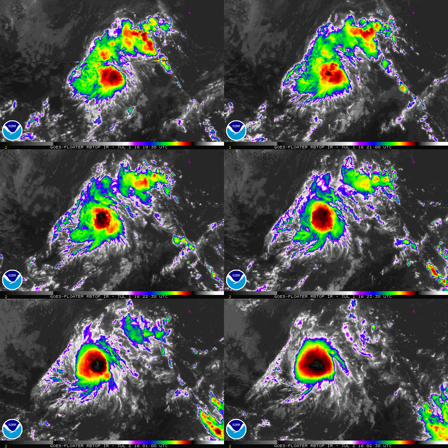
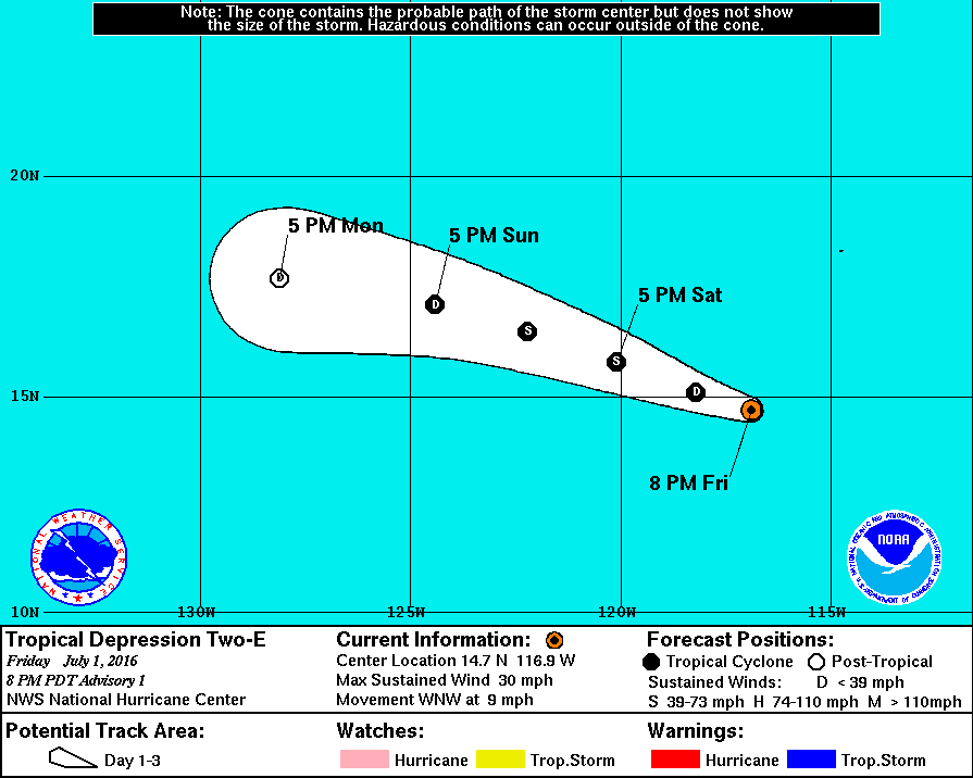
NHC火速升格02E,預計24小時內命名,但不看好發展。
000
WTPZ42 KNHC 020232
TCDEP2

TROPICAL DEPRESSION TWO-E DISCUSSION NUMBER   1
NWS NATIONAL HURRICANE CENTER MIAMI FL       EP022016
800 PM PDT FRI JUL 01 2016

ASCAT data from earlier today indicated that the low pressure area
several hundred miles southwest of the Baja California peninsula had
developed a well-defined circulation.  Deep convection, although
currently sheared to the west of the low-level center, has become
more organized throughout the day, and TAFB and SAB have both given
the system classifications of T1.5.  Advisories are being initiated
on a new tropical depression, with the 25-kt initial intensity based
on the Dvorak estimates and ASCAT data.

The depression is moving west-northwestward, or 300/8 kt, to the
south of the subtropical ridge.  The ridge is expected to remain
relatively stationary, with the cyclone forecast to continue
west-northwestward for the next couple of days.  There are some
speed differences, however, with the ECMWF showing a slightly faster
motion compared with the other track models.  The NHC official
forecast is a little faster than the consensus model trackers, which
did not include the ECMWF solution on this forecast cycle.  After 48
hours, the weakening cyclone is expected to turn westward and then
west-southwestward by day 5.

The depression only has a small window of opportunity to strengthen.
Vertical shear is forecast to be low during the next 36 hours and
then increase significantly in 2 to 3 days.  In addition, the
cyclone should move over water colder than 26 degrees Celsius and
into a much drier mid-level environment in about 36 hours.
Therefore, only modest strengthening to tropical storm strength is
shown in the NHC official forecast in the first day or two, followed
by weakening and degeneration to a remnant low by day 3.

FORECAST POSITIONS AND MAX WINDS

INIT  02/0300Z 14.7N 116.9W   25 KT  30 MPH
12H  02/1200Z 15.1N 118.2W   30 KT  35 MPH
24H  03/0000Z 15.8N 120.1W   35 KT  40 MPH
36H  03/1200Z 16.5N 122.2W   35 KT  40 MPH
48H  04/0000Z 17.1N 124.4W   30 KT  35 MPH
72H  05/0000Z 17.7N 128.1W   25 KT  30 MPH...POST-TROP/REMNT LOW
96H  06/0000Z 17.0N 132.0W   25 KT  30 MPH...POST-TROP/REMNT LOW
120H  07/0000Z 15.5N 135.5W   20 KT  25 MPH...POST-TROP/REMNT LOW

$$
Forecaster Berg
023316W_NL_sm.gif

rbtop-animated.gif
回復

使用道具 舉報

簽到天數: 1988 天

[LV.Master]伴壇終老

ben811018|2016-7-2 16:47 | 顯示全部樓層
02E_tracks_06z.png rb-animated.gif

不看好發展也相當分歧

點評

怎麼覺得有一種地理課本曾經出現過分層設色圖+等高線的感覺XD  發表於 2016-7-2 23:47
alu
jwpk9899 每個熱帶風暴無論發展起不起來都是一顆球  發表於 2016-7-2 23:30
他就這樣一顆球@@  發表於 2016-7-2 16:52
回復

使用道具 舉報

簽到天數: 3279 天

[LV.Master]伴壇終老

t02436|2016-7-2 22:57 | 顯示全部樓層
NHC 15Z正報命名Agatha,雖然02E是自1969年以來東太最晚獲得命名的第一個熱帶風暴,但是是今年東北與西北太平洋第一個獲得命名的熱帶氣旋!
000
WTPZ42 KNHC 021447
TCDEP2

TROPICAL STORM AGATHA DISCUSSION NUMBER   3
NWS NATIONAL HURRICANE CENTER MIAMI FL       EP022016
800 AM PDT SAT JUL 02 2016

Recent SSM/I and AMSR-2 data indicate that the center of Tropical
Depression Two-E has become centrally located in the convective
overcast, and first-light visible imagery shows a large convective
burst near the center.  Satellite intensity estimates at 1200Z were
30 kt from TAFB and SAB.  Based on the increased organization since
that time and a recent CIMSS ADT estimate of 35 kt, the depression
is upgraded to Tropical Storm Agatha, the first named storm of the
2016 eastern Pacific hurricane season.

The initial motion is 295/10.  A low- to mid-level ridge to the
north of the storm should steer it generally west-northwestward for
24 hours or so, followed by a turn toward the west.  Late in the
forecast period, a turn toward the west-southwest is expected as
the remnants of Agatha come under the influence of a larger
tropical weather system to the east.  The new forecast track is
shifted to the north of the previous track based on the initial
position and motion.  However, it lies to the south of the various
consensus models.

Some additional strengthening is possible during the next 12-24
hours while Agatha remains in a light/moderate shear environment
over relatively warm sea surface temperatures.  Beyond that time, a
combination of strong southwesterly shear and cooler sea surface
temperatures should cause a steady weakening.
  Agatha is expected
to weaken to a depression by 48 hours, a remnant low by 72 hours,
and dissipate completely by 120 hours.

Agatha is the latest first tropical storm in the eastern Pacific
since Ava of 1969.


FORECAST POSITIONS AND MAX WINDS

INIT  02/1500Z 15.6N 118.9W   35 KT  40 MPH
12H  03/0000Z 16.2N 120.3W   40 KT  45 MPH
24H  03/1200Z 17.0N 122.5W   40 KT  45 MPH
36H  04/0000Z 17.7N 124.6W   35 KT  40 MPH
48H  04/1200Z 18.1N 126.7W   30 KT  35 MPH
72H  05/1200Z 18.0N 130.5W   25 KT  30 MPH...POST-TROP/REMNT LOW
96H  06/1200Z 17.0N 134.0W   20 KT  25 MPH...POST-TROP/REMNT LOW
120H  07/1200Z...DISSIPATED

$$
Forecaster Beven

145344W_NL_sm.gif

rbtop-animated.gif

點評

西北太平洋完敗  發表於 2016-7-3 00:01
回復

使用道具 舉報

簽到天數: 582 天

[LV.9]以壇為家II

蜜露|2016-7-3 14:11 | 顯示全部樓層
本帖最後由 蜜露 於 2016-7-3 14:14 編輯


東太平洋也是47年來最晚.

這也是1951年來,歷史第五晚的紀錄

1951年以來,第5晚生成首個東太平洋命名強度.

東太平洋
1953   8/23 No-Name 無名
1957   7/15 Kanoa       坎諾亞
1964   7/6   Natalie     娜塔莉
1969   7/3   Ava           艾娃
2016   7/2   Agatha     阿加莎


東太平洋歷史最晚是8月23日........但是他們洋區早期有沒有可能遺漏了不清楚?


評分

參與人數 1水氣能量 +20 收起 理由
ben811018 + 20

查看全部評分

回復

使用道具 舉報

快速回覆
您需要登錄後才可以回帖 登錄 | 立即加入

本版積分規則

KINGRIC

    主題

    帖子

    2萬

    積分

    7級[疾風Near gale]

    Rank: 7Rank: 7Rank: 7

7級[疾風Near gale]

發訊息

本平台僅供學術討論之用,預報應以氣象局為準

威普網站虛擬主機贊助公司

臺灣第一個天氣類型社群平台 即時天氣資訊、精準颱風動態

線上客服
FB傳送訊息
廣告行銷
精準行銷 物超所值
官方粉專
發佈 快速回復 返回頂部 返回列表