開啟輔助訪問
 找回密碼
 立即加入

13E.Lester 長途跋涉達兩周生命史 數次增強減弱

簽到天數: 474 天

[LV.9]以壇為家II

2016-8-23 03:05 | 顯示全部樓層
提示: 作者被禁止或刪除 內容自動屏蔽
回復

使用道具 舉報

簽到天數: 474 天

[LV.9]以壇為家II

劉瑞益@FB|2016-8-23 10:31 | 顯示全部樓層
提示: 作者被禁止或刪除 內容自動屏蔽
回復

使用道具 舉報

簽到天數: 3279 天

[LV.Master]伴壇終老

t02436|2016-8-24 19:18 | 顯示全部樓層
美國海軍發布TCFA
ep992016.20160824093232.gif

NHC:80%
1. Shower activity associated with a low pressure system located about
350 miles south-southwest of Manzanillo, Mexico, continues to show
signs of organization.  Environmental conditions are conducive for
additional development, and a tropical depression is expected to
form later today or on Thursday while the low moves westward or
west-northwestward at 10 to 15 mph away from the coast of Mexico.
* Formation chance through 48 hours...high...80 percent
* Formation chance through 5 days...high...90 percent

two_pac_2d1.png

20160824.1100.goes-15.ircolor.99E.INVEST.25kts.1007mb.14.2N.107.1W.100pc.jpg
回復

使用道具 舉報

簽到天數: 3279 天

[LV.Master]伴壇終老

t02436|2016-8-25 10:38 | 顯示全部樓層
NHC 21Z已升格13E,03Z報巔峰上望75節
000
WTPZ43 KNHC 250231
TCDEP3

TROPICAL DEPRESSION THIRTEEN-E DISCUSSION NUMBER   2
NWS NATIONAL HURRICANE CENTER MIAMI FL       EP132016
900 PM MDT WED AUG 24 2016

The cloud pattern of the depression has become a little better
organized during the past several hours with the center of
circulation located between two curved bands to its north and south.
The initial intensity remains 30 kt for this advisory, in agreement
with a blend of the Dvorak classifications from TAFB and SAB, and
automated values from CIMSS at the University of Wisconsin.  The
tropical cyclone is expected to strengthen during the next 3 to 4
days while it remains over warm water, in a moist environment, and
in moderate wind shear conditions.  Some weakening could occur by
the end of the forecast period when the system moves over cooler
waters and into a drier air mass.  The intensity guidance is in
relatively good agreement, and the NHC forecast is close to the
intensity model consensus.

The depression has been moving west-northwestward at about 10 kt
away from the coast of Mexico.  A decrease in forward speed is
expected on Thursday when the cyclone moves closer to a break in
the subtropical ridge.  The ridge is expected to rebuild to the
north of the cyclone this weekend, and that should cause the system
to move westward at a faster pace.  The NHC track forecast is nudged
to the south of the previous one to be in better agreement with the
latest consensus aids.

FORECAST POSITIONS AND MAX WINDS

INIT  25/0300Z 15.7N 110.9W   30 KT  35 MPH
12H  25/1200Z 16.3N 112.4W   35 KT  40 MPH
24H  26/0000Z 16.8N 113.8W   45 KT  50 MPH
36H  26/1200Z 17.2N 115.1W   55 KT  65 MPH
48H  27/0000Z 17.6N 116.4W   60 KT  70 MPH
72H  28/0000Z 17.8N 119.7W   70 KT  80 MPH
96H  29/0000Z 17.9N 124.4W   75 KT  85 MPH
120H  30/0000Z 18.1N 129.4W   70 KT  80 MPH

$$
Forecaster Cangialosi

023257W_sm.gif

rbtop-animated.gif


回復

使用道具 舉報

簽到天數: 3279 天

[LV.Master]伴壇終老

t02436|2016-8-25 16:44 | 顯示全部樓層
命名Lester。
000
WTPZ43 KNHC 250833
TCDEP3

TROPICAL STORM LESTER DISCUSSION NUMBER   3
NWS NATIONAL HURRICANE CENTER MIAMI FL       EP132016
300 AM MDT THU AUG 25 2016

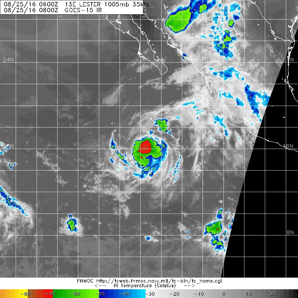
The cyclone appears to be gradually gaining strength.  Recent
microwave images show that the circulation of the system has become
better organized with the associated banding features more tightly
coiled than they were earlier.  In addition, infrared satellite
pictures indicate that a central dense overcast feature has formed
with cloud tops colder than -70 deg C.  The Dvorak classifications
from TAFB and SAB are both 2.5/35 kt, and ADT values from CIMSS at
the University of Wisconsin are a bit higher. Based on these data,
the initial wind speed is increased to 35 kt, making the cyclone
Tropical Storm Lester.

The tropical cyclone is expected to steadily strengthen during the
next 3 to 4 days while it remains over warm water, in a moist
environment, and in moderate wind shear conditions.  By the end of
the forecast period, slight weakening should commence when Lester
moves over cooler water and into a more stable air mass.  The
intensity guidance is a little higher this cycle, and the NHC
forecast is nudged upward to be in closer agreement with the
intensity model consensus.

The microwave passes have been helpful in locating the center,
and suggest that Lester is still moving west-northwestward at 10 kt.
A decrease in forward speed is expected to begin later today when
the cyclone moves closer to a break in the subtropical ridge.  The
ridge is expected to rebuild to the north of the storm this weekend,
and that should cause Lester to move westward at a faster pace.
The NHC track forecast is largely an update of the previous one, and
it lies close to the consensus aids.

FORECAST POSITIONS AND MAX WINDS

INIT  25/0900Z 16.2N 111.6W   35 KT  40 MPH
12H  25/1800Z 16.7N 113.0W   45 KT  50 MPH
24H  26/0600Z 17.2N 114.4W   55 KT  65 MPH
36H  26/1800Z 17.5N 115.8W   60 KT  70 MPH
48H  27/0600Z 17.6N 117.3W   65 KT  75 MPH
72H  28/0600Z 17.7N 121.0W   75 KT  85 MPH
96H  29/0600Z 17.9N 125.8W   80 KT  90 MPH
120H  30/0600Z 18.0N 130.4W   75 KT  85 MPH

$$
Forecaster Cangialosi
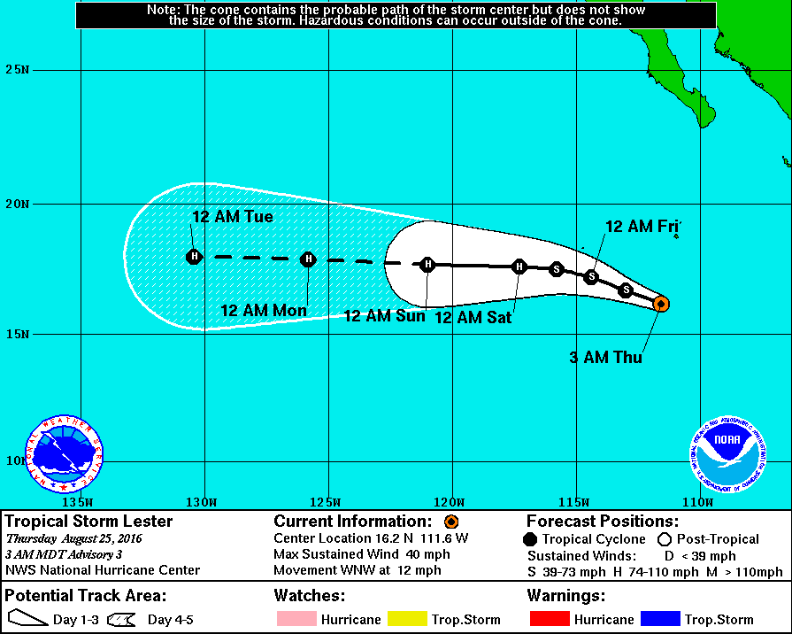
083432W_sm.gif

20160825.0800.goes-15.ircolor.13E.LESTER.35kts.1005mb.16N.111.2W.100pc.jpg
回復

使用道具 舉報

簽到天數: 474 天

[LV.9]以壇為家II

劉瑞益@FB|2016-8-27 11:06 | 顯示全部樓層
提示: 作者被禁止或刪除 內容自動屏蔽
回復

使用道具 舉報

簽到天數: 3279 天

[LV.Master]伴壇終老

t02436|2016-8-29 23:31 | 顯示全部樓層
風眼開了,但不是很渾圓,NHC 15Z給出C3頂評價(110節),兩天半之後以C1頂或C2底強度進入中太。
000
WTPZ43 KNHC 291440
TCDEP3

HURRICANE LESTER DISCUSSION NUMBER  20
NWS NATIONAL HURRICANE CENTER MIAMI FL       EP132016
800 AM PDT MON AUG 29 2016

Lester's satellite presentation is quite impressive this morning.
The cyclone's eye continues to warm and and the inner core
cloud top temperatures have cooled considerably. A blend of 1200
UTC satellite intensity estimates of 105 kt, and a recent ADT
objective intensity estimate yields an increased initial intensity
of 110 kt for this advisory.


Lester should remain in a low-shear environment for the next several
days, with only some gradual decrease in the oceanic water
temperature.  The majority of the intensity guidance indicate that
the hurricane will peak within the next 12 hours or so, then
gradual decrease.  It appears that the atmospheric environment and
the sea surface temperatures match similar criteria for an annular
hurricane manifestation.
If Lester acquires annular hurricane
characteristics, the cyclone could remain stronger longer than
reflected in the official forecast and what the intensity guidance
suggests.  The NHC forecast is adjusted a bit higher in the short
term, then shows gradual weakening and falls in line with the IVCN
multi-model consensus.

The initial motion estimate remains 270/13.  A strong, deep-layer
ridge to the north of Lester should steer the cyclone on a continued
westward course during the next 3 days.  Beyond that period, the
large-scale models indicate some interaction with Madeline to the
southwest of Lester which induces a gradual turn toward the
west-northwest through day 5.  The official forecast follows suit
and is based on a multi-model consensus and is quite similar to the
previous advisory.


FORECAST POSITIONS AND MAX WINDS

INIT  29/1500Z 18.1N 129.2W  110 KT 125 MPH
12H  30/0000Z 18.1N 131.2W  115 KT 130 MPH
24H  30/1200Z 18.2N 133.6W   95 KT 110 MPH
36H  31/0000Z 18.2N 135.9W   90 KT 105 MPH
48H  31/1200Z 18.2N 138.3W   85 KT 100 MPH
72H  01/1200Z 18.4N 143.0W   80 KT  90 MPH
96H  02/1200Z 19.3N 147.9W   75 KT  85 MPH
120H  03/1200Z 21.0N 153.0W   70 KT  80 MPH

$$
Forecaster Roberts

144141W_sm.gif

前方空氣乾的誇張...看有沒有機會變身成環狀颶風
2016EP13_16KMGWVP_201608291200.GIF

2016EP13_OHCNFCST_201608291200.GIF

rbtop-animated.gif
回復

使用道具 舉報

簽到天數: 582 天

[LV.9]以壇為家II

蜜露|2016-8-30 00:08 | 顯示全部樓層


中東太平洋附近 , 相當狀觀的一對雙颶風組合.

瑪德琳上到Cat.2  , 萊斯特更有機會挑戰Cat.4的門檻.
bandicam 2016-08-29 23-56-46-446.jpg


萊斯特目前的樣子真的很美.  美端是東太今年最好看的. 布拉斯反而沒這好看.
(風眼清空必須加強)

20160829.0926.gcomw1.x.colorpct_89h_89v.13ELESTER.100kts-965mb-179N-1271W.62pc.jpg


比較早的時間底層還算不錯.  後期300+h  GFS預報近西太

回復

使用道具 舉報

12下一頁
快速回覆
您需要登錄後才可以回帖 登錄 | 立即加入

本版積分規則

劉瑞益@FB

    主題

    帖子

    104萬

    積分

    13級[一級颶風]

    Rank: 13Rank: 13Rank: 13Rank: 13

13級[一級颶風]

發訊息

本平台僅供學術討論之用,預報應以氣象局為準

威普網站虛擬主機贊助公司

臺灣第一個天氣類型社群平台 即時天氣資訊、精準颱風動態

線上客服
FB傳送訊息
廣告行銷
精準行銷 物超所值
官方粉專
發佈 快速回復 返回頂部 返回列表