開啟輔助訪問
 找回密碼
 立即加入

13P.Debbie 以巔峰強襲昆士蘭 中心登陸逐漸減弱

簽到天數: 474 天

[LV.9]以壇為家II

2017-3-22 10:49 | 顯示全部樓層
提示: 作者被禁止或刪除 內容自動屏蔽
回復

使用道具 舉報

簽到天數: 173 天

[LV.7]常住居民III

W環|2017-3-22 16:40 | 顯示全部樓層
本帖最後由 W環 於 2017-3-22 16:41 編輯

BOM 認為長遠成為熱帶氣旋的機會是中等, JTWC 未有評級.


Tropical Cyclone Outlook for CoralSea
Issued at 2:30 pm EST on Wednesday 22 March 2017
for the period until midnight EST Saturday 25 March 2017.
Existing Cyclones in the Eastern Region:
Nil.
Potential Cyclones:

A low pressure system southeast of the Papua New Guinea mainland is forecast to develop over the next few days while drifting slowly southwest. Conditions are expected to become more favourable for tropical cyclone development in the coming days, particularly from Saturday onwards.
At this stage, the likelihood for a tropical cyclone in the Eastern Region is moderate - this rating should continue into next week.

Likelihood of a tropical cyclone in the Eastern Region on:
Thursday:Very Low
Friday: Low
Saturday:Moderate


NOTES: The likelihood is an estimate of the chance of each system being a tropical cyclone in the Region for each day.
Very Low:less than 5%Low:5% to 20%
Moderate:20 to 50%High:Over 50%


回復

使用道具 舉報

簽到天數: 588 天

[LV.9]以壇為家II

Meow|2017-3-22 19:01 | 顯示全部樓層
ECMWF預期成為2015年Quang以來BoM責任區首個強烈熱帶氣旋,也預期2015年Marcia以來首個登陸昆士蘭的強烈熱帶氣旋。
螢幕快照 2017-03-22 18.56.28.png
登陸強度在950hPa、80kt左右。
回復

使用道具 舉報

簽到天數: 474 天

[LV.9]以壇為家II

劉瑞益@FB|2017-3-23 06:24 | 顯示全部樓層
提示: 作者被禁止或刪除 內容自動屏蔽
回復

使用道具 舉報

簽到天數: 173 天

[LV.7]常住居民III

W環|2017-3-23 09:05 | 顯示全部樓層
沿途SST挺高的,另外跨赤流和東風幅合,幅散良好,有利CISK機制的進行。
image.png
回復

使用道具 舉報

該用戶從未簽到

kibishi0515|2017-3-23 15:24 | 顯示全部樓層
本帖最後由 kibishi0515 於 2017-3-23 15:25 編輯

一對流區域 (追蹤編號91P)之初始位置為接近南緯12.4度,東經154.0度;當前位於接近南緯13.5度東經154.1度,即在威利斯島東北方537.1公里之海面上

THE AREA OF CONVECTION (INVEST 91P) PREVIOUSLY LOCATED NEAR 12.4S 154.0E, IS NOW LOCATED NEAR 13.5S 154.1E, APPROXIMATELY 290 NM NORTHEAST OF WILLIS ISLAND.

動態多色調衛星雲圖及一祖魯時間22日22時52分之AMSU-B METOP A微波圖像顯示數片對流開始覆蓋系統略顯狹長的低層環流中心
擾動現時位於一極向流出環境佳,具有低垂直風切 (10-15節),並且海表面溫度較暖 (攝氏29-30度)的區域。

ANIMATED MULTISPECTRAL SATELLITE IMAGERY AND A 222252Z AMSU-B METOP A MICROWAVE IMAGE SHOW PATCHES OF CONVECTION BEGINNING TO WRAP INTO A SLIGHTLY ELONGATED LOW LEVEL CIRCULATION CENTER (LLCC). THE DISTURBANCE IS CURRENTLY LOCATED IN AN AREA OF GOOD POLEWARD OUTFLOW ALOFT, LOW VERTICAL WIND SHEAR (10-15 KNOTS), AND WARM SEA SURFACE TEMPERATURES (29-30 C).

全球模式支持此系統在未來數天中向西南移動並逐漸增強

GLOBAL MODELS ARE IN AGREEMENT THAT THE DISTURBANCE WILL CONTINUE TO TRACK TO THE SOUTHWEST WITH INTENSIFICATION GRADUALLY OCCURRING OVER THE NEXT SEVERAL DAYS.

此系統之最大持續風速推估為10至15節,最低氣壓推估為接近1005百帕

MAXIMUM SUSTAINED SURFACE WINDS ARE ESTIMATED AT 10 TO 15 KNOTS. MINIMUM SEA LEVEL PRESSURE IS ESTIMATED TO BE NEAR 1005 MB.

未來24小時內此系統成為一顯著熱帶氣旋之可能性評級維持

THE POTENTIAL FOR THE DEVELOPMENT OF A SIGNIFICANT TROPICAL CYCLONE WITHIN THE NEXT 24 HOURS REMAINS LOW.

abpwsair.jpg


回復

使用道具 舉報

簽到天數: 4434 天

[LV.Master]伴壇終老

s6815711|2017-3-24 06:09 | 顯示全部樓層
13Z評級提升至Medium
(1) THE AREA OF CONVECTION (INVEST 91P) PREVIOUSLY LOCATED
NEAR 12.4S 154.0E, IS NOW LOCATED NEAR 14.7S 152.2E, APPROXIMATELY
161 NM NORTHEAST OF WILLIS ISLAND. ANIMATED ENHANCED INFRARED
SATELLITE IMAGERY AND A 230813Z SSMIS MICROWAVE IMAGE SHOW PATCHES
OF CONVECTION BEGINNING TO WRAP INTO A STILL SLIGHTLY ELONGATED LOW
LEVEL CIRCULATION CENTER (LLCC) WITH SOME BANDING BEGINNING TO FORM.
THE DISTURBANCE IS CURRENTLY LOCATED IN AN AREA OF GOOD OUTFLOW
ALOFT, LOW VERTICAL WIND SHEAR (10-15 KNOTS), AND WARM SEA SURFACE
TEMPERATURES (29-30 C). GLOBAL MODELS ARE IN AGREEMENT THAT THE
DISTURBANCE WILL CONTINUE TO TRACK TO THE SOUTHWEST WITH
INTENSIFICATION GRADUALLY OCCURRING OVER THE NEXT SEVERAL DAYS.
MAXIMUM SUSTAINED SURFACE WINDS ARE ESTIMATED AT 10 TO 15 KNOTS.
MINIMUM SEA LEVEL PRESSURE IS ESTIMATED TO BE NEAR 1005 MB. THE
POTENTIAL FOR THE DEVELOPMENT OF A SIGNIFICANT TROPICAL CYCLONE
WITHIN THE NEXT 24 HOURS IS UPGRADED TO MEDIUM.


abpwsair.jpg

回復

使用道具 舉報

簽到天數: 3279 天

[LV.Master]伴壇終老

t02436|2017-3-24 12:24 | 顯示全部樓層
JTWC發布TCFA
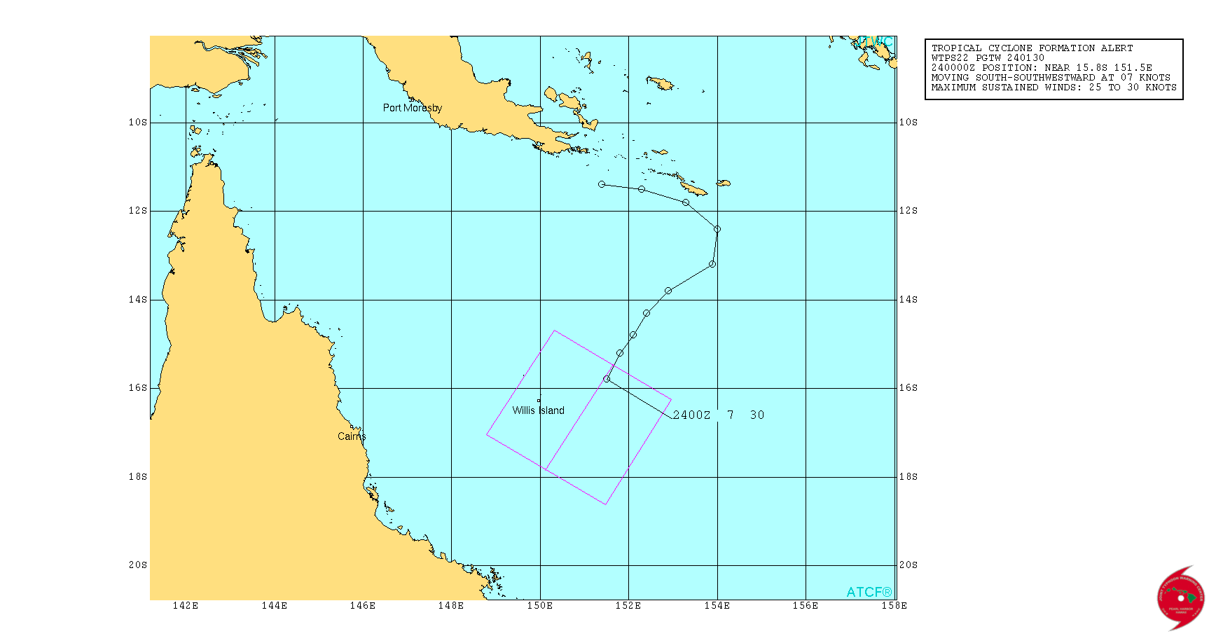
sh912017.20170324010229.gif

BoM編號24U,巔峰上望85節的三級強烈熱帶氣旋。
IDQ20018
TROPICAL CYCLONE TECHNICAL BULLETIN: AUSTRALIA - EASTERN REGION
Issued by BRISBANE TROPICAL CYCLONE WARNING CENTRE
at: 0408 UTC 24/03/2017
Name: Tropical Low  
Identifier: 24U
Data At: 0000 UTC
Latitude: 16.1S
Longitude: 151.4E
Location Accuracy: within 60 nm [110 km]
Movement Towards: south [173 deg]
Speed of Movement: 8 knots [15 km/h]
Maximum 10-Minute Wind: 25 knots [45 km/h]
Maximum 3-Second Wind Gust: 45 knots [85 km/h]
Central Pressure: 1003 hPa
Radius of 34-knot winds NE quadrant:   
Radius of 34-knot winds SE quadrant:   
Radius of 34-knot winds SW quadrant:   
Radius of 34-knot winds NW quadrant:   
Radius of 48-knot winds NE quadrant:   
Radius of 48-knot winds SE quadrant:   
Radius of 48-knot winds SW quadrant:   
Radius of 48-knot winds NW quadrant:   
Radius of 64-knot winds:   
Radius of Maximum Winds:   
Dvorak Intensity Code: T2.0/2.0/D1.0/24HRS
Pressure of outermost isobar: 1009 hPa
Radius of outermost closed isobar: 240 nm [445 km]
FORECAST DATA
Date/Time    : Location    : Loc. Accuracy: Max Wind   : Central Pressure
[UTC]        : degrees     :      nm  [km]: knots[km/h]: hPa
+06:  24/0600: 16.5S 151.6E:     070 [135]:  025  [045]: 1006
+12:  24/1200: 16.8S 151.4E:     085 [155]:  030  [055]: 1003
+18:  24/1800: 16.9S 151.3E:     090 [165]:  035  [065]:  999
+24:  25/0000: 17.1S 151.0E:     100 [185]:  040  [075]:  997
+36:  25/1200: 17.2S 150.6E:     100 [185]:  045  [085]:  994
+48:  26/0000: 17.5S 149.8E:     110 [205]:  065  [120]:  980
+60:  26/1200: 17.8S 148.8E:     120 [220]:  080  [150]:  968
+72:  27/0000: 18.2S 147.4E:     130 [240]:  085  [155]:  964
+96:  28/0000: 18.9S 144.6E:     160 [295]:  045  [085]:  983
+120: 29/0000: 19.9S 142.0E:     320 [590]:  030  [055]: 1004
REMARKS:
Position fix is considered fair based on a combination of animated visible
imagery, Willis Island radar and peripheral surface observations. The tropical
low has been showing signs of development over the past 24 hours. Multiple
episodes of deep convection, showing some curvature, have developed near the
centre in the past 12 to 24 hours, although they have remained somewhat
transient in nature. Dvorak analysis was based on a curved band wrapping 0.4 to
0.5 in both Vis and IR imagery, yileding a DT of 2.5. Given the transient nature
of this convection though, the FT was biased towards the MET and PT of 2.0.

The low is currently being steered to the south by the combination of a mid
level ridge to the east, and an upper level trough moving eastwards across the
Tasman Sea. During the weekend, this trough is expected to move further east,
and a new mid level ridge should build to the south of the system, leading to a
change to a westerly track, taking the cyclone onto the Queensland coast. All
model guidance is in agreement with this scenario, although there are
significant differences in forward speed amongst the guidance, which affects not
only the time of impact, but also the length of time available for the system to
intensify over the water.

The system is located in an area of weak vertical wind shear over SSTs of 29 to
30 deg C. Upper level outflow is unrestricted in all quadrants, and may become
enhanced to the south due to the weak interaction with the upper trough.
Overall, the environment will remain supportive of intensification right up to
landfall on the Queensland coast, and it is reasonably likely that the system
will have sufficient time over water to reach category 3 status. A period of
more rapid intensification cannot be ruled out, which would lead to a higher
category system at landfall.  

Copyright Commonwealth of Australia
==
The next bulletin for this system will be issued by: 24/0730 UTC by Brisbane
TCWC.
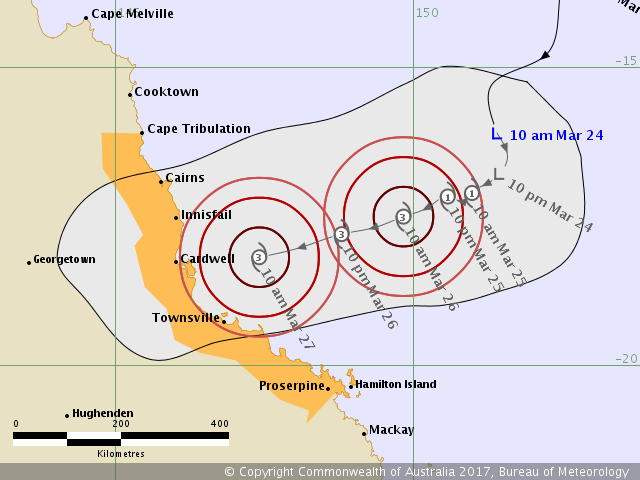
IDQ65001.png

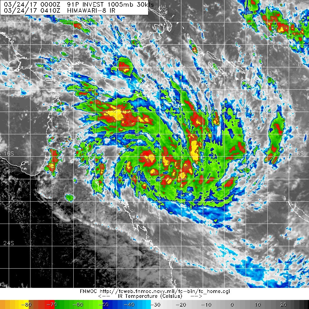
20170324.0410.himawari-8.ircolor.91P.INVEST.30kts.1005mb.15.8S.151.5E.100pc.jpg

點評

雲圖動畫也拿錯了,這是Caleb不是24U。  發表於 2017-3-24 12:35
是85不是80  發表於 2017-3-24 12:33
回復

使用道具 舉報

1234下一頁
快速回覆
您需要登錄後才可以回帖 登錄 | 立即加入

本版積分規則

劉瑞益@FB

    主題

    帖子

    104萬

    積分

    13級[一級颶風]

    Rank: 13Rank: 13Rank: 13Rank: 13

13級[一級颶風]

發訊息

本平台僅供學術討論之用,預報應以氣象局為準

威普網站虛擬主機贊助公司

臺灣第一個天氣類型社群平台 即時天氣資訊、精準颱風動態

線上客服
FB傳送訊息
廣告行銷
精準行銷 物超所值
官方粉專
發佈 快速回復 返回頂部 返回列表