簽到天數: 3279 天 [LV.Master]伴壇終老
|
 t02436|2017-9-5 22:48
|
顯示全部樓層
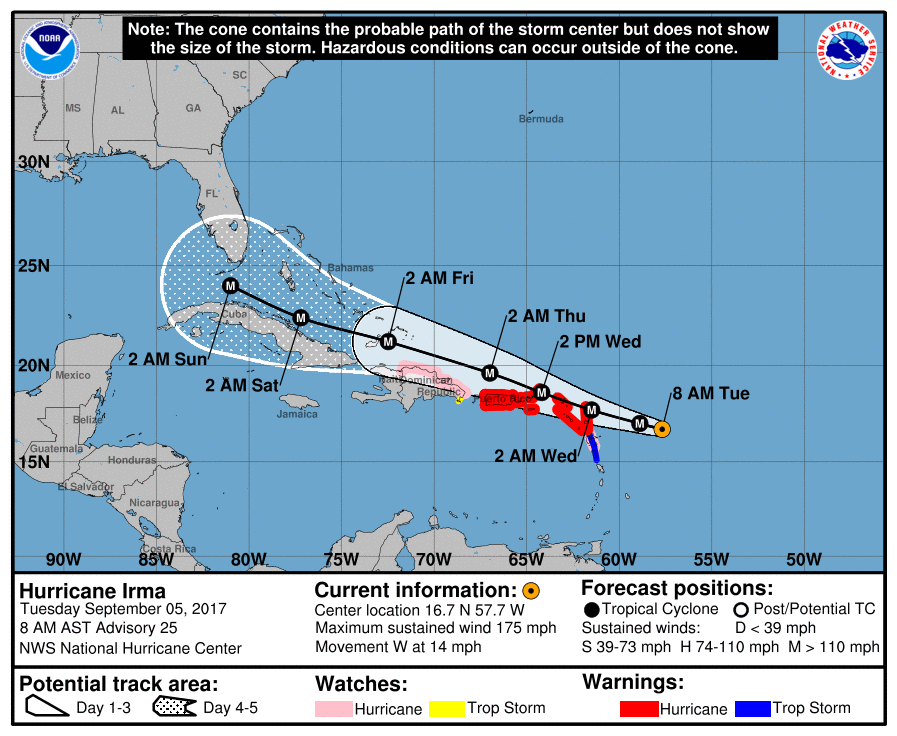
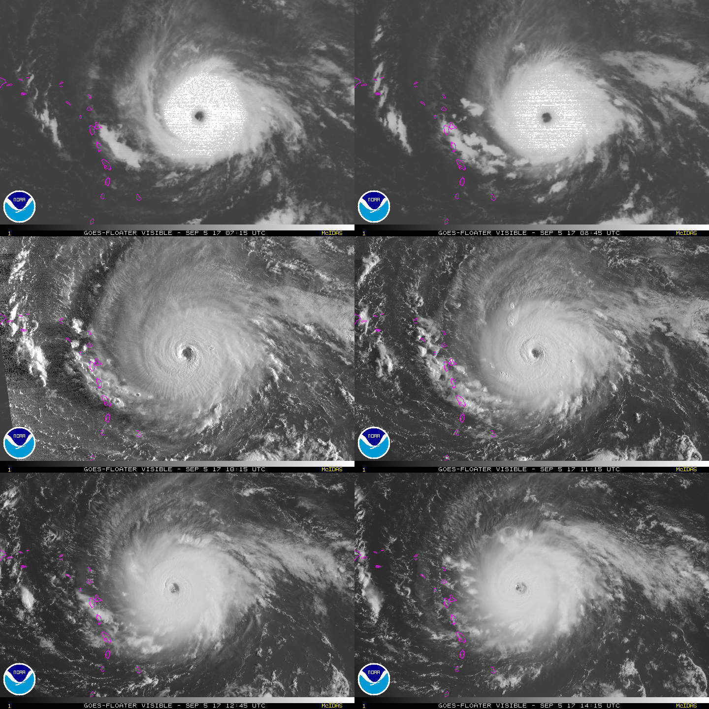
升上C5第一報正報,評價150節,上望155節。
000
WTNT41 KNHC 051200
TCDAT1
Hurricane Irma Special Discussion Number 25
NWS National Hurricane Center Miami FL AL112017
800 AM AST Tue Sep 05 2017
This special advisory is being issued to increase the initial and
forecast intensity of Irma.
NOAA and U.S. Air Force Hurricane Hunter aircraft have recently
measured peak flight-level winds of around 170 kt and SFMR winds
of around 150 kt. Based on these data the initial intensity has
been increased to 150 kt, making Irma an extremely dangerous
category 5 hurricane. Some additional strengthening is still
possible, but fluctuations in intensity are likely during the next
couple of days due to eyewall replacement cycles.
No change was made to the previous track or wind radii forecast.
KEY MESSAGES:
1. Irma is expected to affect the northeastern Leeward Islands as
an extremely dangerous category 5 hurricane, accompanied by
life-threatening wind, storm surge, and rainfall. Hurricane warnings
are in effect for portions of the Leeward Islands. Preparations
should be rushed to completion, as tropical-storm force winds are
expected to first arrive in the hurricane warning area later today.
2. Irma is also expected to affect the British and U.S. Virgin
Islands and Puerto Rico as a dangerous major hurricane beginning
tomorrow, with life-threatening wind, storm surge, and rainfall.
Hurricane warnings have been issued for these areas, and tropical-
storm-force winds are expected to arrive in these areas by early
tomorrow.
3. Irma could directly affect Hispaniola, the Turks and Caicos, the
Bahamas, and Cuba as an extremely dangerous major hurricane later
this week. Residents in these areas should monitor the progress of
Irma and listen to advice given by officials.
4. There is an increasing chance of seeing some impacts from Irma in
the Florida Peninsula and the Florida Keys later this week and this
weekend. Otherwise, it is still too early to determine what direct
impacts Irma might have on the continental United States. However,
everyone in hurricane-prone areas should ensure that they have their
hurricane plan in place.
FORECAST POSITIONS AND MAX WINDS
INIT 05/1200Z 16.7N 57.7W 150 KT 175 MPH
12H 05/1800Z 17.0N 58.9W 155 KT 180 MPH
24H 06/0600Z 17.7N 61.5W 150 KT 175 MPH
36H 06/1800Z 18.6N 64.2W 145 KT 165 MPH
48H 07/0600Z 19.6N 67.0W 140 KT 160 MPH
72H 08/0600Z 21.2N 72.5W 135 KT 155 MPH
96H 09/0600Z 22.4N 77.2W 135 KT 155 MPH
120H 10/0600Z 24.0N 81.0W 130 KT 150 MPH
$$
Forecaster Brown


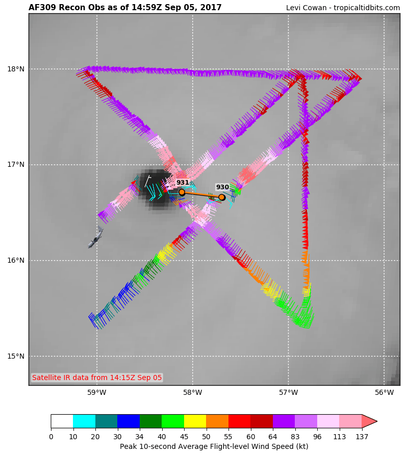
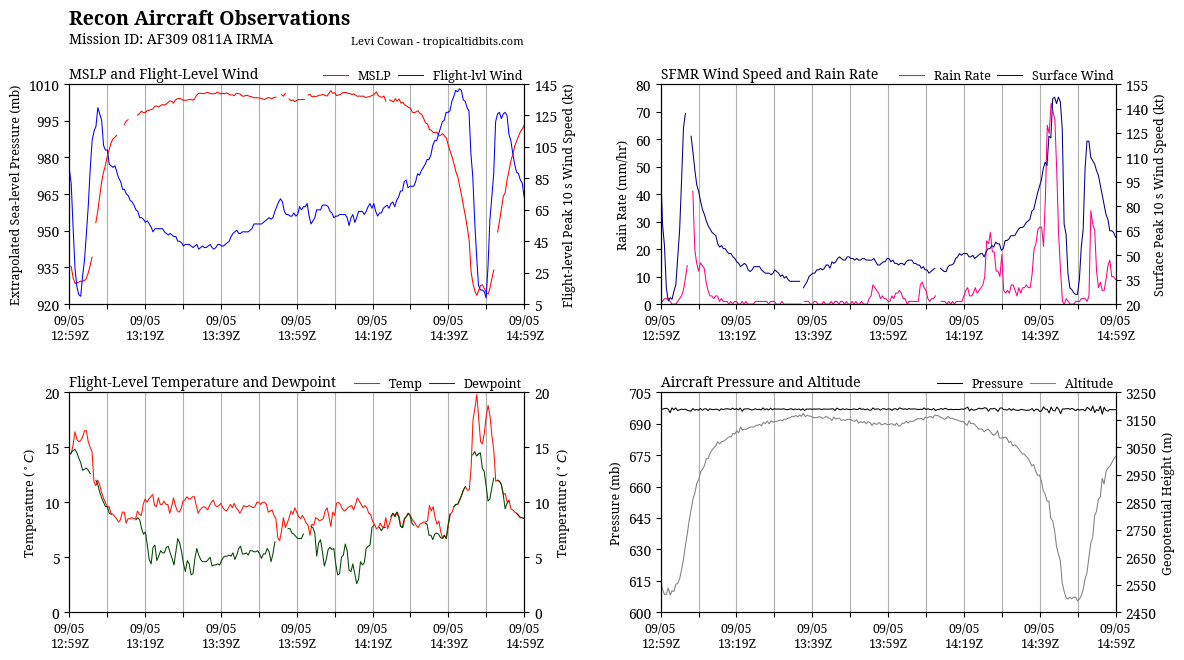
補充:第三次穿心完成,評價150節合理。
144000 1657N 05804W 6980 02892 9801 +091 //// 160130 134 103 021 05
144030 1656N 05805W 6969 02880 9773 +096 +096 163133 137 107 039 03
144100 1656N 05806W 6968 02854 9741 +098 +098 162138 141 105 065 03
144130 1655N 05807W 6951 02854 9720 +098 +098 160138 140 123 062 03
144200 1655N 05809W 6979 02791 9681 +102 +102 161140 142 122 073 03
144230 1654N 05810W 6963 02782 9645 +106 +106 161136 141 146 070 00
144300 1654N 05811W 6960 02746 9600 +111 +111 164133 135 147 067 00
144330 1653N 05812W 6979 02689 9560 +114 +114 162130 134 143 048 03
144400 1653N 05814W 6969 02661 9512 +111 //// 161128 130 147 025 01
144430 1652N 05815W 6948 02637 9460 +111 //// 159112 128 144 012 05
144500 1652N 05817W 6970 02556 9332 +131 //// 154094 101 128 001 05
144530 1651N 05819W 6970 02526 9284 +175 +143 152069 086 069 000 00
144600 1650N 05820W 6971 02504 9253 +185 +146 149046 058 063 002 03
144630 1649N 05822W 6972 02498 9236 +198 +142 149024 036 039 001 00
144700 1648N 05823W 6968 02505 9257 +176 +144 153014 017 030 000 00
144730 1648N 05825W 6973 02499 9277 +155 +145 169012 014 029 000 00
144800 1647N 05827W 6968 02505 9279 +153 +131 155013 014 027 000 03
144830 1647N 05829W 6962 02505 9264 +163 +128 149011 013 026 001 00
144900 1646N 05830W 6969 02492 9247 +179 +115 021002 009 026 001 00
144930 1644N 05832W 6964 02498 9241 +188 +101 326021 029 035 001 00
145000 1643N 05833W 6967 02510 9267 +178 +103 316048 059 055 002 03
145030 1641N 05834W 6967 02533 9306 +160 +113 313070 073 066 002 00
145100 1640N 05835W 6961 02571 9340 +147 +122 313084 088 103 002 00
145130 1639N 05837W 6978 02593 //// +119 //// 310107 121 120 001 01
145200 1638N 05838W 6971 02649 9495 +120 +120 304124 126 120 003 03
145230 1637N 05839W 6961 02701 9540 +119 +119 308124 127 110 034 00
145300 1637N 05840W 6984 02721 9592 +116 +116 310117 123 108 029 00
145330 1635N 05841W 6953 02801 9641 +107 +107 312122 126 106 027 00
145400 1634N 05842W 6967 02817 9656 +108 +094 316125 127 102 012 00
145430 1633N 05843W 6961 02861 9710 +100 +099 321115 125 099 006 00
145500 1632N 05844W 6983 02869 9745 +102 +101 323110 113 093 008 00


|
評分
-
查看全部評分
|