開啟輔助訪問
 找回密碼
 立即加入

99L 風切干擾

簽到天數: 601 天

[LV.9]以壇為家II

2017-9-29 03:10 | 顯示全部樓層
本帖最後由 s6815711 於 2017-10-1 20:45 編輯

基本資料   
編號    :99 L
擾動編號日期:2017 09 29 03
撤編日期  :2017 10 01 20
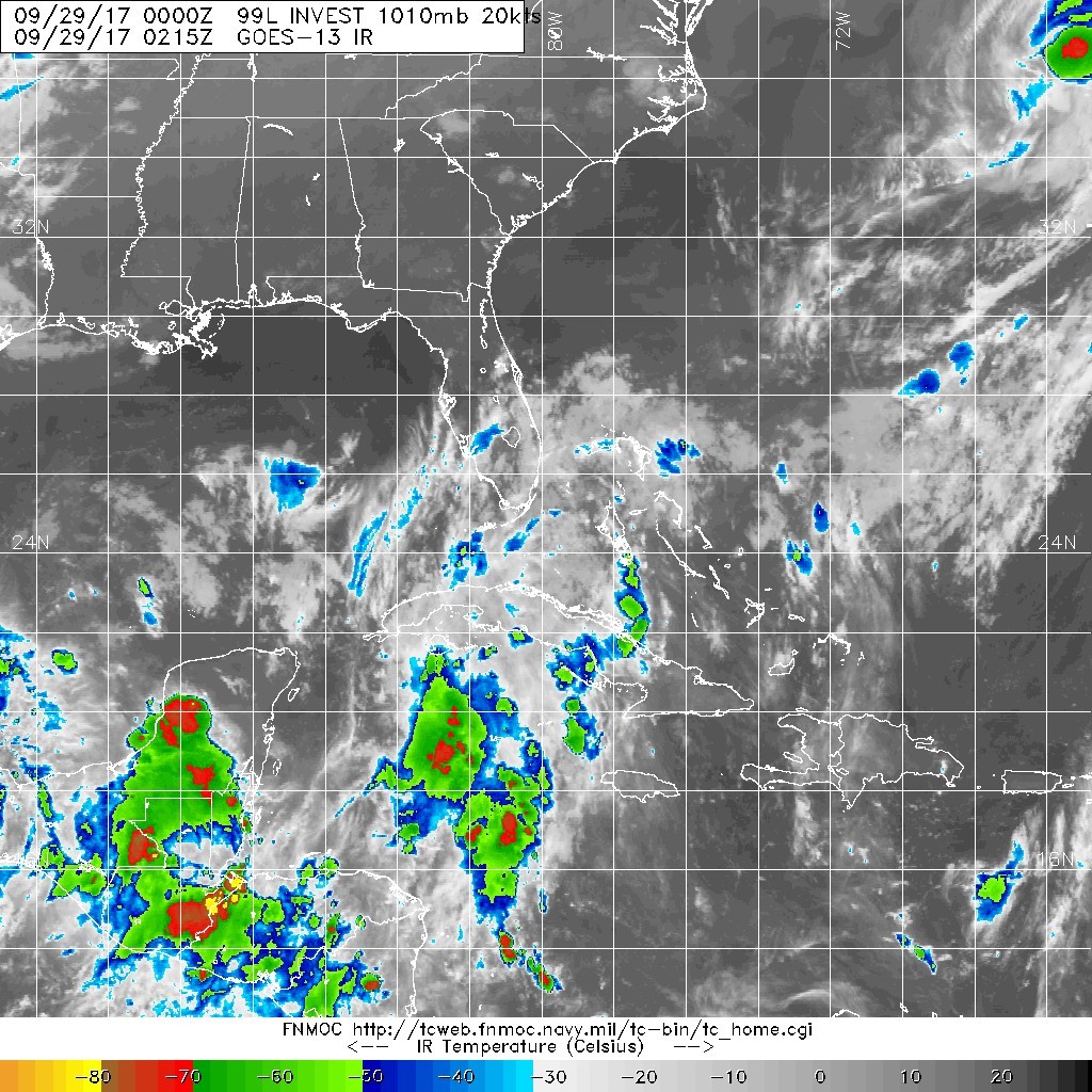
99L-INVEST-20kts-1012mb-23.3N-79.6W

20170928.1845.goes13.x.vis1km_high.99LINVEST.20kts-1012mb-233N-796W.100pc.jpg
NHC : 20%
1. A large area of cloudiness and showers extending from the
northwestern Caribbean Sea across Cuba to the Bahamas is associated
with a surface trough interacting with an upper-level low.  An area
of low pressure is likely to form from this weather system while it
moves northward across Cuba and near the east coast of the Florida
peninsula during the next few days, and environmental conditions
appear conducive for development before upper-level winds become
less favorable early next week.  Regardless of development, this
system is likely to produce locally heavy rainfall over portions of
Cuba, southern Florida, the Florida Keys, and the Bahamas during the
next several days.
* Formation chance through 48 hours...low...20 percent.
* Formation chance through 5 days...medium...40 percent.

two_atl_2d1 (4).png

評分

參與人數 1水氣能量 +15 收起 理由
s6815711 + 15

查看全部評分

回復

使用道具 舉報

簽到天數: 601 天

[LV.9]以壇為家II

霧峰追風者|2017-9-29 11:10 | 顯示全部樓層
NHC 展望提升至40%
1. A large area of cloudiness and showers extending from the
northwestern Caribbean Sea northward across Cuba to the Florida
Straits is associated with a broad surface trough interacting with
an upper-level low.  A weak area of low pressure is likely to form
from this weather system near the Florida Straits on Friday, and it
is forecast to move northward near the east coast of the Florida
Peninsula through Saturday.  Environmental conditions appear
to be conducive for some development during the next couple of days,
before upper-level winds become less favorable on Sunday.
Regardless of development, this system is likely to produce
locally heavy rainfall over portions of central and western Cuba,
the Florida Keys, the Florida peninsula, and the northwestern
Bahamas during the next several days.
* Formation chance through 48 hours...medium...40 percent.
* Formation chance through 5 days...medium...50 percent.
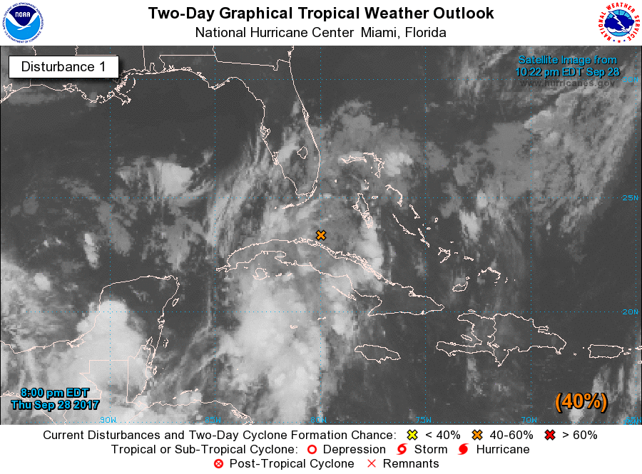
two_atl_2d1 (5).png 20170929.0215.goes-13.ircolor.99L.INVEST.20kts.1010mb.24.2N.79.9W.100pc.jpg


回復

使用道具 舉報

簽到天數: 601 天

[LV.9]以壇為家II

霧峰追風者|2017-9-30 17:41 | 顯示全部樓層
NHC 展望降低至30%,登陸佛州。
1. The interaction of a weak low pressure area over central Florida
and an upper-level low over the Gulf of Mexico is producing
disorganized cloudiness and showers that extend from the
northwestern Caribbean Sea northward across much of the Florida
peninsula and the adjacent waters.  Due to the low's interaction
with land and an expected increase of upper-level winds over the
weekend, the likelihood of this system's development appears to be
decreasing.  Locally heavy rainfall is still anticipated over
portions of western Cuba, the Florida Keys, and the Florida
peninsula during the next several days while the system moves
slowly northward and then westward near northern Florida and the
northeastern Gulf of Mexico.
* Formation chance through 48 hours...low...30 percent.
* Formation chance through 5 days...low...30 percent.
two_atl_2d1 (6).png

點評

強度已經達標,可能直升TS.  發表於 2017-10-1 18:34
回復

使用道具 舉報

簽到天數: 601 天

[LV.9]以壇為家II

霧峰追風者|2017-10-1 20:52 | 顯示全部樓層
NHC 展望降低至0%,風切干擾,不看好發展。
1. A trough of low pressure that extends from the eastern Gulf of
Mexico across portions of Florida is producing an area of
disorganized showers and thunderstorms and gusty winds near the east
coast of central and northern Florida.  Although development of
this system is not expected due to strong upper-level winds,
gusty winds and locally heavy rains are likely to continue over
portions of northeastern Florida and southeastern Georgia
through tonight.  Please see statements from local National Weather
Service forecast offices for additional information.
* Formation chance through 48 hours...low...near 0 percent.
* Formation chance through 5 days...low...near 0 percent.
wg8sht.GIF


這張雲圖是早上的
20171001.0345.goes-13.ircolor.99L.INVEST.35kts.1012mb.29.6N.80.8W.100pc.jpg


點評

北半球恢復平靜了  發表於 2017-10-1 21:07
回復

使用道具 舉報

快速回覆
您需要登錄後才可以回帖 登錄 | 立即加入

本版積分規則

霧峰追風者

    主題

    帖子

    220萬

    積分

    16級[四級颶風]

    Rank: 16Rank: 16Rank: 16Rank: 16

16級[四級颶風]

發訊息

本平台僅供學術討論之用,預報應以氣象局為準

威普網站虛擬主機贊助公司

臺灣第一個天氣類型社群平台 即時天氣資訊、精準颱風動態

線上客服
FB傳送訊息
廣告行銷
精準行銷 物超所值
官方粉專
發佈 快速回復 返回頂部 返回列表