開啟輔助訪問
 找回密碼
 立即加入

16P.Nora 卡灣發展 巔峰短暫 登陸約克角半島

簽到天數: 601 天

[LV.9]以壇為家II

2018-3-20 05:34 | 顯示全部樓層
本帖最後由 ... 於 2018-3-28 21:34 編輯

  三級強烈熱帶氣旋  
編號:22 U ( 16 P )
名稱:Nora
800px-Nora_2018-03-24_0412Z.jpg
  基本資料  
擾動編號日期:2018 03 20 05
JTWC升格日期:2018 03 22 14
命名日期  :2018 03 23 02
撤編日期  :2018 03 00 00
登陸地點  :澳大利亞 約克角半島

  巔峰時期資料  
近中心最大風速:
澳洲氣象局 (BoM):85 kt
聯合颱風警報中心 (JTWC):95 kts ( Cat.2 )
海平面最低氣壓:959 百帕

  過去路徑圖  
1920px-Nora_2018_track.png
  擾動編號資料  
94P-INVEST-15kts-1005mb-11.0S-146.0E

20180319.2100.himawari-8.vis.94P.INVEST.15kts.1005mb.11S.146E.100pc.jpg

以上資料來自:BoM、JTWC、颱風論壇整理製作

評分

參與人數 1水氣能量 +15 +1 收起 理由
krichard2011 + 15 + 1

查看全部評分

回復

使用道具 舉報

簽到天數: 601 天

[LV.9]以壇為家II

霧峰追風者|2018-3-20 19:26 | 顯示全部樓層
JTWC 05Z評級Low
(1) AN AREA OF CONVECTION (INVEST 94P) HAS PERSISTED NEAR 7.4S
137.1E, APPROXIMATELY 228 NM NORTH-NORTHEAST OF GOVE AIRPORT,
AUSTRALIA. ANIMATED MULTISPECTRAL SATELLITE IMAGERY DEPICTS A WEAKLY
DEFINED, LOW LEVEL CIRCULATION CENTER (LLCC) WITH DISORGANIZED,
FLARING CONVECTION OVER THE WESTERN QUADRANT. A 192353Z ASCAT PASS
SHOWS A DEFINED BUT BROAD CIRCULATION WITH 15-20 KNOT WINDS. UPPER
LEVEL ANALYSIS SHOWS THAT THE SYSTEM IS LOCATED IN AN UNFAVORABLE
ENVIRONMENT WITH MODERATE (20-25 KNOT) VERTICAL WIND SHEAR AND
CONVERGENT FLOW ALOFT. GLOBAL MODELS SHOW THAT 94P WILL TRACK
SOUTHWARD OVER THE NEXT 48 HOURS INTO A MORE FAVORABLE ENVIRONMENT
WITH RAPID DEVELOPMENT FORECAST AS THE SYSTEM APPROACHES NORTHERN
AUSTRALIA. MAXIMUM SUSTAINED SURFACE WINDS ARE ESTIMATED AT 15 TO 20
KNOTS. MINIMUM SEA LEVEL PRESSURE IS ESTIMATED TO BE NEAR 1005 MB.
THE POTENTIAL FOR THE DEVELOPMENT OF A SIGNIFICANT TROPICAL CYCLONE
WITHIN THE NEXT 24 HOURS IS LOW.
abpwsair.jpg 20180320.1050.himawari-8.ir.94P.INVEST.15kts.1002mb.7.9S.137.2E.100pc.jpg

回復

使用道具 舉報

簽到天數: 3279 天

[LV.Master]伴壇終老

t02436|2018-3-21 14:21 | 顯示全部樓層
BoM看好發展
IDD65001.png

94P_gefs_latest.png

rbtop-animated.gif
回復

使用道具 舉報

簽到天數: 601 天

[LV.9]以壇為家II

霧峰追風者|2018-3-22 03:28 | 顯示全部樓層
JTWC 18Z直接發佈TCFA,趨向北澳陸地。
WTPS21 PGTW 211830
MSGID/GENADMIN/JOINT TYPHOON WRNCEN PEARL HARBOR HI//
SUBJ/TROPICAL CYCLONE FORMATION ALERT//
RMKS/
1. FORMATION OF A SIGNIFICANT TROPICAL CYCLONE IS POSSIBLE WITHIN
145 NM EITHER SIDE OF A LINE FROM 9.6S 135.5E TO 13.2S 138.4E
WITHIN THE NEXT 12 TO 24 HOURS. AVAILABLE DATA DOES NOT JUSTIFY
ISSUANCE OF NUMBERED TROPICAL CYCLONE WARNINGS AT THIS TIME.
WINDS IN THE AREA ARE ESTIMATED TO BE 25 TO 30 KNOTS. METSAT
IMAGERY AT 211800Z INDICATES THAT A CIRCULATION CENTER IS LOCATED
NEAR 10.0S 135.9E. THE SYSTEM IS MOVING EAST-SOUTHEASTWARD AT 06
KNOTS.
2. REMARKS:
THE AREA OF CONVECTION (INVEST 94P) PREVIOUSLY LOCATED NEAR 8.4S
136.5E, IS NOW LOCATED NEAR 10.0S 135.9E, APPROXIMATELY 150 NM NORTH-
NORTHWEST OF GOVE AIRPORT, AUSTRALIA. ANIMATED ENHANCED INFRARED
SATELLITE IMAGERY AND A 211208Z 89GHZ AMSU MICROWAVE IMAGE DEPICTS
FLARING DEEP CONVECTION BEGINNING TO WRAP INTO A RAPIDLY
CONSOLIDATING LOW LEVEL CIRCULATION CENTER (LLCC). INVEST 94P HAS
MOVED INTO AN AREA OF LOW-MODERATE (10-20KT) VERTICAL WIND SHEAR
WITH VERY STRONG DIVERGENCE ALOFT. SEA SURFACE TEMPERATURES ARE
CONDUCIVE TO DEVELOPMENT (28-30 CELSIUS) BOTH IN THE ARAFURA SEA AND
TO THE SOUTHEAST IN THE GULF OF CARPENTARIA WHERE INVEST 94P IS
EXPECTED TO TRACK. GLOBAL MODELS ARE IN GOOD AGREEMENT THE SYSTEM
WILL DEVELOP IN THE NEXT 12 TO 24 HOURS TRACKING TO THE SOUTHEAST
AND IS EXPECTED TO BE SHORT LIVED AS IT MAKES LANDFALL OVER
NORTHWESTERN QUEENSLAND. HOWEVER, WITH FAVORABLE ENVIRONMENTAL
CONDITIONS THE POTENTIAL FOR RAPID DEVELOPMENT INTO A SIGNIFICANT
TROPICAL CYCLONE IS HIGH. MAXIMUM SUSTAINED SURFACE WINDS ARE
ESTIMATED AT 25 TO 30 KNOTS. MINIMUM SEA LEVEL PRESSURE IS ESTIMATED
TO BE NEAR 998 MB. THE POTENTIAL FOR THE DEVELOPMENT OF A
SIGNIFICANT TROPICAL CYCLONE WITHIN THE NEXT 24 HOURS IS HIGH.
3. THIS ALERT WILL BE REISSUED, UPGRADED TO WARNING OR CANCELLED BY
221830Z.//
NNNN
sh9418.gif abpwsair (1).jpg 20180321.1850.himawari-8.ir.94P.INVEST.30kts.998mb.10S.135.9E.100pc.jpg

回復

使用道具 舉報

簽到天數: 3279 天

[LV.Master]伴壇終老

t02436|2018-3-22 15:50 | 顯示全部樓層
BoM編號22U,預測一天內命名。
IDD20020
TROPICAL CYCLONE TECHNICAL BULLETIN: AUSTRALIA - NORTHERN REGION
Issued by DARWIN TROPICAL CYCLONE WARNING CENTRE
at: 0721 UTC 22/03/2018
Name: Tropical Low  
Identifier: 22U
Data At: 0600 UTC
Latitude: 9.8S
Longitude: 135.9E
Location Accuracy: within 45 nm [85 km]
Movement Towards: east [084 deg]
Speed of Movement: 9 knots [17 km/h]
Maximum 10-Minute Wind: 30 knots [55 km/h]
Maximum 3-Second Wind Gust: 45 knots [85 km/h]
Central Pressure: 995 hPa
Radius of 34-knot winds NE quadrant:   
Radius of 34-knot winds SE quadrant:   
Radius of 34-knot winds SW quadrant:   
Radius of 34-knot winds NW quadrant:   
Radius of 48-knot winds NE quadrant:   
Radius of 48-knot winds SE quadrant:   
Radius of 48-knot winds SW quadrant:   
Radius of 48-knot winds NW quadrant:   
Radius of 64-knot winds:   
Radius of Maximum Winds:   
Dvorak Intensity Code: T2.5/2.5/D1.5/12HRS
Pressure of outermost isobar: 1003 hPa
Radius of outermost closed isobar: 210 nm [390 km]
FORECAST DATA
Date/Time    : Location    : Loc. Accuracy: Max Wind   : Central Pressure
[UTC]        : degrees     :      nm  [km]: knots[km/h]: hPa
+06:  22/1200:  9.8S 136.2E:     070 [135]:  030  [055]:  995
+12:  22/1800:  9.8S 136.5E:     085 [155]:  030  [055]:  994
+18:  23/0000: 10.0S 137.1E:     095 [180]:  035 [065]:  993
+24:  23/0600: 10.4S 137.9E:     110 [200]:  040  [075]:  993
+36:  23/1800: 11.4S 139.3E:     130 [240]:  055  [100]:  984
+48:  24/0600: 13.0S 140.7E:     150 [275]:  065  [120]:  977
+60:  24/1800: 14.3S 141.1E:     170 [310]:  080  [150]:  962
+72:  25/0600: 15.3S 141.0E:     185 [345]:  080  [150]:  961
+96:  26/0600: 15.2S 141.3E:     230 [430]:  080  [150]:  961
+120: 27/0600: 15.7S 140.6E:     320 [590]:  080  [150]:  964
REMARKS:
Overnight satellite imagery has shown an increase in convection along the
monsoon trough through the Arafura Sea. Convection has fired consistently near
the centre in the early hours of the morning suggesting that the system has
reached T1.0.

The low is currently on the edge of the high shear environment but this is
expected to change during the day as the low moves under the upper ridge. The
environment remains favourable into the weekend for development and the system
should reach hurricane strength on Sunday. An upper trough passing to the south
on Friday and Saturday will enhance the outflow to the south.

Copyright Commonwealth of Australia
==
The next bulletin for this system will be issued by: 22/1400 UTC by Darwin TCWC.

IDD65001.png

回復

使用道具 舉報

簽到天數: 601 天

[LV.9]以壇為家II

霧峰追風者|2018-3-22 16:40 | 顯示全部樓層
本帖最後由 霧峰追風者 於 2018-3-22 18:10 編輯

JTWC 06Z率先升格熱帶氣旋,編號16P。 sh1618.gif abpwsair.jpg
20180322.0810.himawari-8.ircolor.16P.SIXTEEN.35kts.996mb.10.2S.135.6E.100pc.jpg

回復

使用道具 舉報

簽到天數: 601 天

[LV.9]以壇為家II

霧峰追風者|2018-3-22 22:10 | 顯示全部樓層
BoM 12Z風速達標,還沒命名,巔峰上望澳式C3。
IDD20020
TROPICAL CYCLONE TECHNICAL BULLETIN: AUSTRALIA - NORTHERN REGION
Issued by DARWIN TROPICAL CYCLONE WARNING CENTRE
at: 1356 UTC 22/03/2018
Name: Tropical Low  
Identifier: 22U
Data At: 1200 UTC
Latitude: 9.9S
Longitude: 136.4E
Location Accuracy: within 45 nm [85 km]
Movement Towards: east southeast [101 deg]
Speed of Movement: 5 knots [9 km/h]
Maximum 10-Minute Wind: 35 knots [65 km/h]
Maximum 3-Second Wind Gust: 50 knots [95 km/h]
Central Pressure: 994 hPa
Radius of 34-knot winds NE quadrant: 90 nm [165 km]
Radius of 34-knot winds SE quadrant:   
Radius of 34-knot winds SW quadrant:   
Radius of 34-knot winds NW quadrant: 90 nm [165 km]
Radius of 48-knot winds NE quadrant:   
Radius of 48-knot winds SE quadrant:   
Radius of 48-knot winds SW quadrant:   
Radius of 48-knot winds NW quadrant:   
Radius of 64-knot winds:   
Radius of Maximum Winds:   
Dvorak Intensity Code: T2.5/2.5/D1.0/12HRS STT:S0.0/06HRS
Pressure of outermost isobar: 1002 hPa
Radius of outermost closed isobar: 150 nm [280 km]
FORECAST DATA
Date/Time    : Location    : Loc. Accuracy: Max Wind   : Central Pressure
[UTC]        : degrees     :      nm  [km]: knots[km/h]: hPa
+06:  22/1800:  9.9S 136.8E:     055 [105]:  040  [075]:  993
+12:  23/0000: 10.1S 137.4E:     070 [130]:  045  [085]:  991
+18:  23/0600: 10.6S 138.1E:     080 [150]:  050  [095]:  988
+24:  23/1200: 11.2S 138.8E:     095 [175]:  055  [100]:  986
+36:  24/0000: 12.6S 140.0E:     115 [210]:  065  [120]:  975
+48:  24/1200: 14.2S 140.6E:     135 [245]:  075  [140]:  967
+60:  25/0000: 15.5S 140.4E:     155 [285]:  080  [150]:  959
+72:  25/1200: 16.0S 140.0E:     170 [320]:  080  [150]:  958
+96:  26/1200: 15.9S 140.3E:     215 [400]:  080  [150]:  958
+120: 27/1200: 16.4S 138.9E:     300 [560]:  080  [150]:  962


回復

使用道具 舉報

簽到天數: 601 天

[LV.9]以壇為家II

霧峰追風者|2018-3-23 03:30 | 顯示全部樓層
本帖最後由 霧峰追風者 於 2018-3-23 05:11 編輯

BoM 18Z命名"NORA",卡灣發展,巔峰上望澳式C3。
IDD20020
TROPICAL CYCLONE TECHNICAL BULLETIN: AUSTRALIA - NORTHERN REGION
Issued by DARWIN TROPICAL CYCLONE WARNING CENTRE
at: 2000 UTC 22/03/2018
Name: Tropical Cyclone Nora
Identifier: 22U
Data At: 1800 UTC
Latitude: 9.9S
Longitude: 136.7E
Location Accuracy: within 40 nm [75 km]
Movement Towards: east [090 deg]
Speed of Movement: 3 knots [5 km/h]
Maximum 10-Minute Wind: 35 knots [65 km/h]
Maximum 3-Second Wind Gust: 50 knots [95 km/h]
Central Pressure: 992 hPa
Radius of 34-knot winds NE quadrant: 90 nm [165 km]
Radius of 34-knot winds SE quadrant:   
Radius of 34-knot winds SW quadrant:   
Radius of 34-knot winds NW quadrant: 90 nm [165 km]
Radius of 48-knot winds NE quadrant:   
Radius of 48-knot winds SE quadrant:   
Radius of 48-knot winds SW quadrant:   
Radius of 48-knot winds NW quadrant:   
Radius of 64-knot winds:   
Radius of Maximum Winds: 30 nm [55 km]
Dvorak Intensity Code: T3.0/3.0/D1.5/24HRS STT:D0.5/06HRS
Pressure of outermost isobar: 1002 hPa
Radius of outermost closed isobar: 180 nm [335 km]
FORECAST DATA
Date/Time    : Location    : Loc. Accuracy: Max Wind   : Central Pressure
[UTC]        : degrees     :      nm  [km]: knots[km/h]: hPa
+06:  23/0000: 10.1S 137.3E:     055 [105]:  040  [075]:  991
+12:  23/0600: 10.5S 137.9E:     070 [130]:  045  [085]:  988
+18:  23/1200: 11.1S 138.6E:     080 [150]:  050  [095]:  985
+24:  23/1800: 11.8S 139.2E:     095 [175]:  055  [100]:  980
+36:  24/0600: 13.4S 140.2E:     115 [210]:  065  [120]:  971
+48:  24/1800: 14.8S 140.4E:     135 [245]:  075  [140]:  962
+60:  25/0600: 15.7S 140.1E:     155 [285]:  080  [150]:  958
+72:  25/1800: 16.0S 139.9E:     170 [320]:  080  [150]:  957
+96:  26/1800: 15.8S 140.1E:     215 [400]:  080  [150]:  957
+120: 27/1800: 16.6S 137.5E:     300 [560]:  075  [140]:  972
REMARKS:
Satellite imagery has shown an increasing circular low-level circulation centre
[LLCC] and strong convective bursts developing near the LLCC.

Confidence in the location of the LLCC is fair and based on a combination of
infrared satellite imagery, Gove radar and a 1108Z AMSUB 37GHz microwave image
which shows a small, consolidating LLCC.

Dvorak analysis at 1800Z yielded a CI of 3.0, based on a 3h averaged DT of 2.5
using a 0.5 wrap. MET was set at 2.5 while PAT equaled 3.0. CIMSS and NESDIS ADT
is 2.8, while SATCON at 1107 UTC gave a 39 knot system. Intensity is set at 35
knots [10 min-mean]. Cape Wessel Automatic Weather Station [66nm south of the
system] reported 32 knots at 1200 UTC. A ship located in the southeast quadrant
has reported 35 knots within 65 nautical miles of the LLCC. A sonde flight at
0600Z at Gove showed winds have increased to 35-40 knots between 900-850 hPa.

CIMSS indicates the vertical wind shear is reducing and at 1800UTC was easterly
at 5 to 10 knots, as the tropical cyclone moves beneath the upper ridge.
Tropical Cyclone Nora is expected to develop rapidly during today due to dual
outflow channels to
both the north and south, aided by a mid-latitude upper trough, and low vertical
wind shear. The system is expected to reach peak intensity as a Category 3 [80
kn] tropical cyclone Saturday night/Sunday morning. During Sunday, an increase
in vertical wind shear and land interaction are expected to restrict further
development and ultimately weaken the system. NWP is varied in the maximum
intensity of this system.

The system is currently being steered to the east southeast by a westerly wind
surge, which will take it into the Gulf of Carpentaria during today. A weakness
in the mid level ridge over southern Queensland allows the system to adopt a
southwards track into the southern Gulf of Carpentaria during Saturday and
Sunday. Most NWP tracks follow this scenario although UK and ACCESS-G take a
more easterly track over Cape York Peninsula. The influence of a mid-level ridge
over Western Australia is expected to slow the movement of the system from
Sunday over the southeast Gulf of Carpentaria and from Monday, west-southwest is
expected to take the system over inland Australia.

Copyright Commonwealth of Australia
==
The next bulletin for this system will be issued by: 23/0200 UTC by Darwin TCWC.
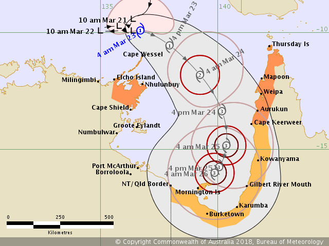
IDD65001.png

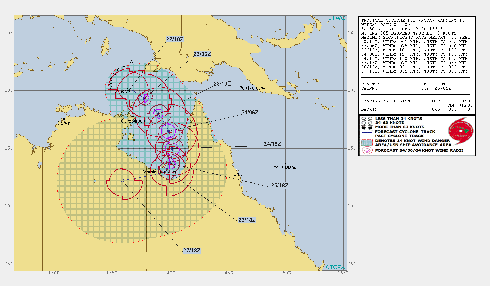
JTWC 第3報強度上望四級颶風( 120kts ),也預測登陸前強度會逐漸減弱... sh162018.20180322204919.gif
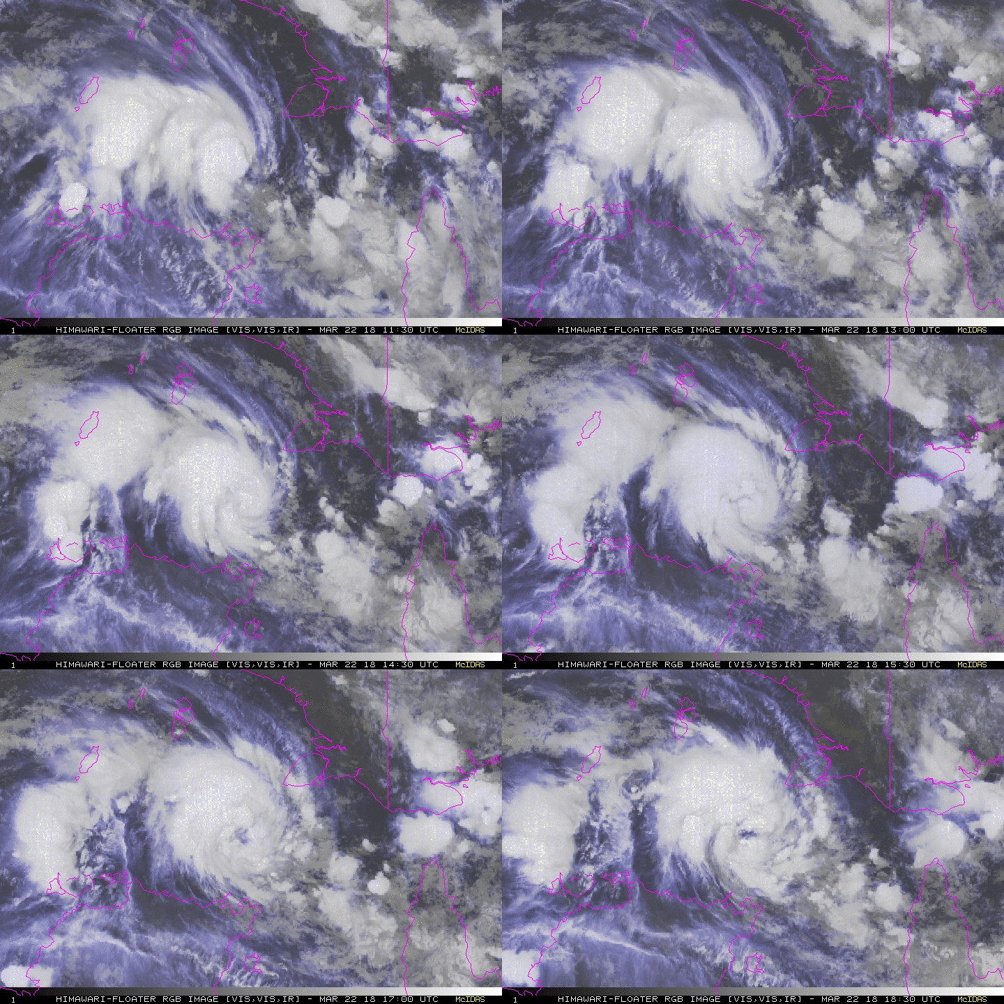
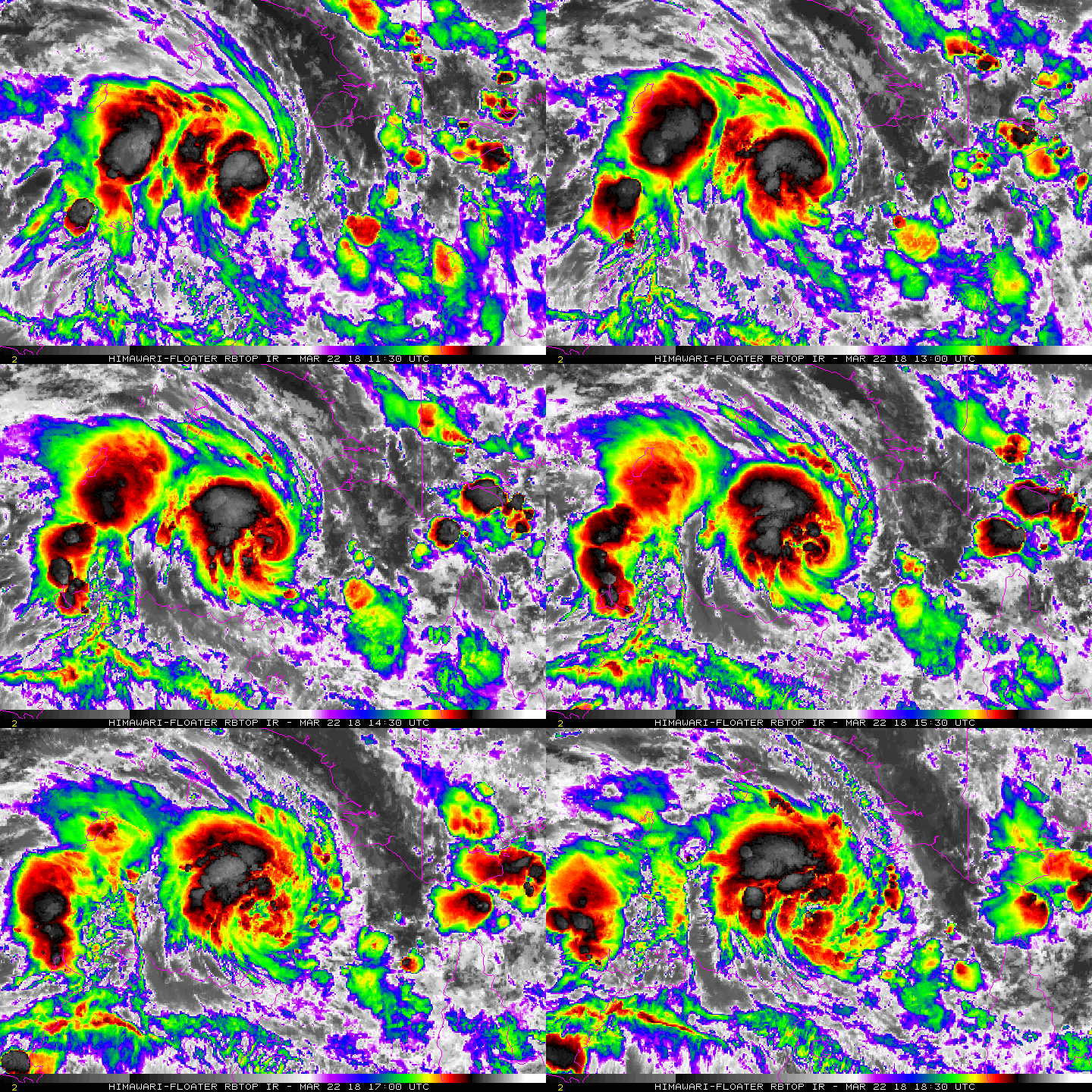
rgb-animated (2).gif rbtop-animated (2).gif
回復

使用道具 舉報

12下一頁
快速回覆
您需要登錄後才可以回帖 登錄 | 立即加入

本版積分規則

霧峰追風者

    主題

    帖子

    220萬

    積分

    16級[四級颶風]

    Rank: 16Rank: 16Rank: 16Rank: 16

16級[四級颶風]

發訊息

本平台僅供學術討論之用,預報應以氣象局為準

威普網站虛擬主機贊助公司

臺灣第一個天氣類型社群平台 即時天氣資訊、精準颱風動態

線上客服
FB傳送訊息
廣告行銷
精準行銷 物超所值
官方粉專
發佈 快速回復 返回頂部 返回列表