開啟輔助訪問
 找回密碼
 立即加入

02E.Aletta 環境轉差 逐漸減弱

簽到天數: 601 天

[LV.9]以壇為家II

2018-6-4 20:48 | 顯示全部樓層
本帖最後由 霧峰追風者 於 2019-3-17 17:00 編輯

  四級颶風  
編號:02 E
名稱:Aletta
800px-Aletta_2018-06-08_1825Z.jpg
  基本資料  
擾動編號日期:2018 06 04 20
命名日期  :2018 06 06 14
撤編日期  :2018 06 00 00
登陸地點  :

  巔峰時期資料  
近中心最強風速
國家颶風中心(NHC):120 kts
海平面最低氣壓943 百帕

  過去路徑圖  
1280px-Aletta_2018_track.png
  擾動編號資料  
91E-INVEST.15kts-1011mb-15.0N-105.0W

20180604.1200.goes-15.ir.91E.INVEST.15kts.1011mb.15N.105W.100pc.jpg
NHC : 40%
1. Widespread but disorganized showers and thunderstorms are associated
with a trough of low pressure located a few hundred miles south of
the southern coast of Mexico.  Environmental conditions are
expected to be conducive for development of this system, and a
tropical depression is expected to form in the next few days while
it moves slowly west-northwestward.
* Formation chance through 48 hours...medium...40 percent.
* Formation chance through 5 days...high...90 percent.

two_pac_2d1 (1).png

以上資料來自:NHC颱風論壇整理製作

評分

參與人數 1水氣能量 +15 +1 收起 理由
king111807 + 15 + 1 熱帶擾動首帖

查看全部評分

回復

使用道具 舉報

簽到天數: 601 天

[LV.9]以壇為家II

霧峰追風者|2018-6-5 04:58 | 顯示全部樓層
本帖最後由 霧峰追風者 於 2018-6-6 07:51 編輯

JTWC 發佈"TCFA",NHC 展望提升至60%。
WTPN21 PHNC 041430
MSGID/GENADMIN/JOINT TYPHOON WRNCEN PEARL HARBOR HI//
SUBJ/TROPICAL CYCLONE FORMATION ALERT//
RMKS/
1. FORMATION OF A SIGNIFICANT TROPICAL CYCLONE IS POSSIBLE WITHIN
155 NM EITHER SIDE OF A LINE FROM 10.4N 101.3W TO 13.9N 106.0W
WITHIN THE NEXT 12 TO 24 HOURS. AVAILABLE DATA DOES NOT JUSTIFY
ISSUANCE OF NUMBERED TROPICAL CYCLONE WARNINGS AT THIS TIME.
WINDS IN THE AREA ARE ESTIMATED TO BE 15 TO 20 KNOTS. METSAT IMAGERY
AT 041330Z INDICATES THAT A CIRCULATION CENTER IS LOCATED NEAR 10.5N
101.6W. THE SYSTEM IS MOVING WEST-NORTHWESTWARD AT 05 KNOTS.
2. REMARKS:
THE AREA OF CONVECTION (INVEST 91E) PREVIOUSLY LOCATED NEAR 10.3N
101.1W, IS NOW LOCATED NEAR 10.5N 101.6W, APPROXIMATELY
394 NM SOUTH-SOUTHWEST OF ACAPULCO, MEXICO. ANIMATED MULTISPECTRAL
SATELLITE IMAGERY DEPICTS A BROAD AREA OF CONVERGENCE WITH
ASSOCIATED FLARING CONVECTION. A 041108Z SSMIS 91GHZ MICROWAVE IMAGE
DEPICTS THE DEEP CONVECTION IS DISORGANIZED. ENVIRONMENTAL
CONDITIONS SUPPORT FURTHER DEVELOPMENT WITH THE SYSTEM MOVING FROM
AN AREA OF MODERATE (15-20 KTS) VERTICAL WIND SHEAR (VWS) INTO AN
AREA OF LOW VWS. SSTS ARE WARM (28-29C) AND WILL SUPPORT
DEVELOPMENT. GLOBAL MODELS ARE IN GOOD AGREEMENT MAINTAINING A
CIRCULATION TRACKING TO THE NORTH-NORTHWEST WITH STEADY
INTENSIFICATION IN LATER TAUS. MAXIMUM SUSTAINED SURFACE WINDS ARE
ESTIMATED AT 15 TO 20 KNOTS. MINIMUM SEA LEVEL PRESSURE IS ESTIMATED
TO BE NEAR 1007 MB. THE POTENTIAL FOR THE DEVELOPMENT OF A
SIGNIFICANT TROPICAL CYCLONE WITHIN THE NEXT 24 HOURS IS HIGH.
3. THIS ALERT WILL BE REISSUED, UPGRADED TO WARNING OR CANCELLED BY
051430Z.//
NNNN
ep912018.18060406.gif two_pac_2d1.png 20180604.1800.goes15.x.vis1km_high.91EINVEST.20kts-1009mb-111N-1037W.100pc.jpg
回復

使用道具 舉報

簽到天數: 601 天

[LV.9]以壇為家II

霧峰追風者|2018-6-5 19:16 | 顯示全部樓層
本帖最後由 霧峰追風者 於 2018-6-6 07:51 編輯

NHC 展望提升至70%
1. A broad and elongated area of low pressure located several hundred
miles south of the southern coast of Mexico continues to produce a
large area of disorganized showers and thunderstorms. Environmental
conditions are conducive for the development of this system, and a
tropical depression is likely to form within the next couple of
days while it moves slowly westward to west-northwestward.
* Formation chance through 48 hours...high...70 percent.
* Formation chance through 5 days...high...90 percent.

two_pac_2d1 (1).png 20180605.0900.goes15.x.ir1km_bw.91EINVEST.20kts-1009mb-117N-1035W.100pc.jpg

回復

使用道具 舉報

簽到天數: 601 天

[LV.9]以壇為家II

霧峰追風者|2018-6-6 08:13 | 顯示全部樓層
NHC 展望提升至百分之百,即將升格。
1. Satellite images indicate that the circulation associated with a
low pressure system located several hundred miles south of
Manzanillo, Mexico, continues to become better defined, and it
appears that a tropical depression is forming.  Continued
development is expected, and advisories could be initiated on this
system as early as this evening or early Wednesday while the low
moves west-northwestward at about 10 mph south of the coast of
Mexico.
* Formation chance through 48 hours...high...near 100 percent.
* Formation chance through 5 days...high...near 100 percent.
two_pac_2d1 (2).png 91E_intensity_latest.png 91E_gefs_latest.png

回復

使用道具 舉報

簽到天數: 601 天

[LV.9]以壇為家II

霧峰追風者|2018-6-6 09:00 | 顯示全部樓層
本帖最後由 霧峰追風者 於 2018-6-6 12:01 編輯

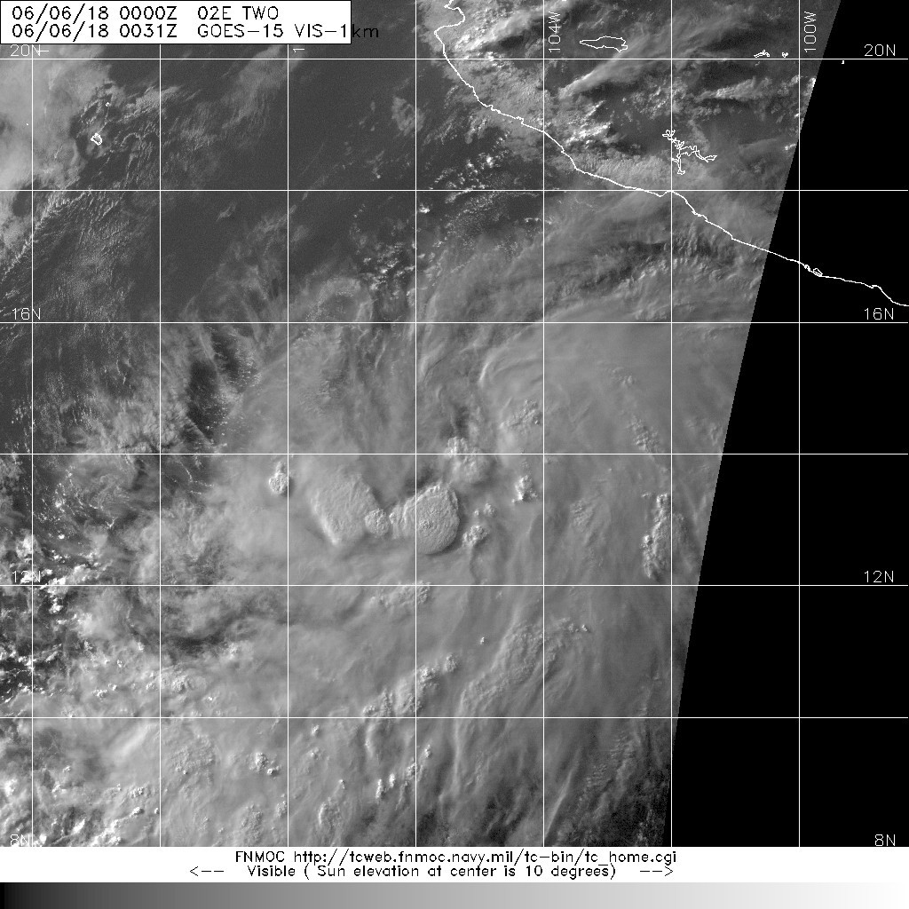
00Z升格熱帶低壓,編號02E,巔峰上望二級颶風。
000
WTPZ42 KNHC 060232
TCDEP2

Tropical Depression Two-E Discussion Number   1
NWS National Hurricane Center Miami FL       EP022018
1000 PM CDT Tue Jun 05 2018

During the past several hours, a prominent convective band began
developing in association with the low pressure system that we have
been tracking south of Mexico during the past few days.  In using
that band for Dvorak estimates, TAFB provided a satellite intensity
estimate of T2.0/30 kt while SAB provided an estimate of T1.5/25
kt.  In addition, GOES-16 1-minute visible satellite imagery showed
that the low had developed a closed surface circulation and a
well-defined center.  Advisories are therefore being initiated on
Tropical Depression Two-E, with an initial intensity of 30 kt based
on an earlier partial ASCAT pass.

The depression is currently moving northwestward, or 305/8 kt.
However, due to a mid-level ridge centered over northwestern Mexico,
the cyclone is expected to turn westward and slow down during the
next 24 hours.  By days 3-5, the cyclone should reach a weakness in
the ridge, allowing it to turn back toward the northwest but
maintain its slow motion.  While the dynamical models all generally
agree on this scenario, there are some noticeable differences in the
guidance.  The ECMWF lies to the south of the other models, while
the HWRF is to the north and generally faster than the other
guidance.  For this first official forecast, the NHC prediction lies
close to the HFIP Corrected Consensus Approach (HCCA) and is of
average confidence.

Environmental conditions appear ideal for intensification.  Sea
surface temperatures will be close to 30 degrees Celsius for the
next 36 hours, while at the same time deep-layer shear will be very
low and upper-level divergence will be high.  In response, the Rapid
Intensification Indices are giving a 50/50 chance of a 45-kt
increase in 36 hours and a 55-kt increase in 48 hours.  As a
result, the NHC official intensity forecast is rather aggressive and
lies slightly above the highest guidance through the first 3 days,
making the cyclone a hurricane by 36 hours.  Gradual weakening is
expected on days 4 and 5 when the hurricane reaches cooler waters.


FORECAST POSITIONS AND MAX WINDS

INIT  06/0300Z 14.1N 105.7W   30 KT  35 MPH
12H  06/1200Z 14.3N 106.7W   40 KT  45 MPH
24H  07/0000Z 14.5N 107.8W   55 KT  65 MPH
36H  07/1200Z 14.7N 108.9W   65 KT  75 MPH
48H  08/0000Z 14.8N 109.9W   75 KT  85 MPH
72H  09/0000Z 15.3N 112.1W   85 KT 100 MPH
96H  10/0000Z 16.5N 113.5W   80 KT  90 MPH
120H  11/0000Z 17.5N 115.0W   70 KT  80 MPH

$$
Forecaster Berg
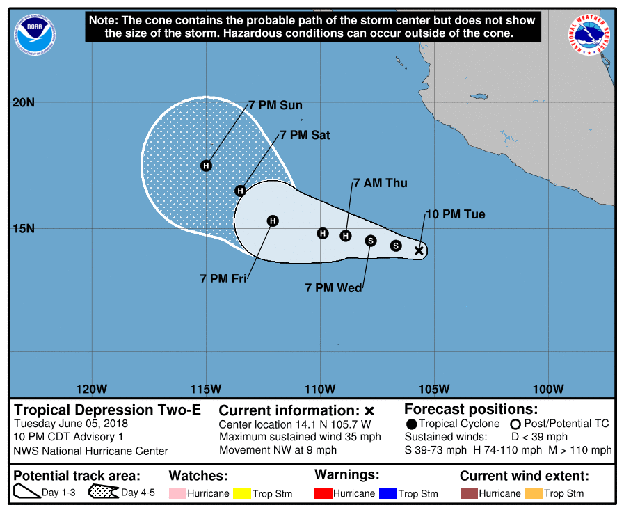
023350_5day_cone_no_line_and_wind.png

20180606.0031.goes-15.vis.1km.02E.TWO.30kts.1005mb.14N.105.4W.095pc.jpg

回復

使用道具 舉報

簽到天數: 601 天

[LV.9]以壇為家II

霧峰追風者|2018-6-6 14:50 | 顯示全部樓層
本帖最後由 霧峰追風者 於 2018-6-6 16:49 編輯

NHC 06Z命名"Aletta",逐漸增強。
000
WTPZ42 KNHC 060832
TCDEP2

Tropical Storm Aletta Discussion Number   2
NWS National Hurricane Center Miami FL       EP022018
300 AM MDT Wed Jun 06 2018

Deep convection has increased significantly during the past 12
hours, and the cloud pattern is better organized with the formation
of a few cyclonically curved bands. The outflow is fair in all
quadrants. An ASCAT pass a few hours ago, indicate that the winds
are between 35 to 40 kt, but these winds are confined to a band to
the east of the center.  On this basis, the depression has been
upgraded to Tropical Storm Aletta, the first named system of the
2018 eastern North Pacific season.

An prevailing environment of low shear favors intensification, and
although the Rapid Intensification Indices are not as high as
earlier, they are still on the high side. The NHC forecast calls for
Aletta to become a hurricane in 36 hours as indicated in the
previous forecast. After 3 days, when the cyclone reaches cooler
water and higher shear, a gradual weakening is anticipated.

It appears that Aletta is moving toward the west at about 6 kt
around the periphery of a subtropical ridge centered over
northwestern Mexico. However, a weakness in the ridge should cause
the cyclone to gradually gain some latitude during the next few days
with no significant change in forward speed. The NHC forecast
follows the model consensus, and it is basically centered in the
middle of the guidance envelope bounded by the GFS to the north
and the ECMWF to the south.


FORECAST POSITIONS AND MAX WINDS

INIT  06/0900Z 14.1N 106.5W   40 KT  45 MPH
12H  06/1800Z 14.2N 107.4W   45 KT  50 MPH
24H  07/0600Z 14.4N 108.5W   55 KT  65 MPH
36H  07/1800Z 14.6N 109.3W   65 KT  75 MPH
48H  08/0600Z 15.0N 110.5W   75 KT  85 MPH
72H  09/0600Z 15.5N 112.5W   80 KT  90 MPH
96H  10/0600Z 16.5N 114.5W   70 KT  80 MPH
120H  11/0600Z 17.0N 116.0W   50 KT  60 MPH

$$
Forecaster Avila
083331_5day_cone_no_line_and_wind.png 20180606.0600.goes-15.ir.02E.ALETTA.35kts.1004mb.14.1N.106.2W.100pc.jpg rbtop-animated (2).gif
回復

使用道具 舉報

簽到天數: 1765 天

[LV.Master]伴壇終老

zjk369|2018-6-6 15:04 | 顯示全部樓層
已命名
Tropical Storm ALETTA
As of 06:00 UTC Jun 06, 2018:
Location: 14.1°N 106.2°W
Maximum Winds: 35 kt  Gusts: N/A
Minimum Central Pressure: 1004 mb
Environmental Pressure: 1009 mb
Radius of Circulation: 210 NM
Radius of Maximum Wind: 90 NM
Eye Diameter: N/A
回復

使用道具 舉報

簽到天數: 582 天

[LV.9]以壇為家II

蜜露|2018-6-6 21:13 | 顯示全部樓層


東太平洋第一號颶風 , 上望就很看好 ..是個無害颶風 . 後面可能還會跟隨另一個 .

gfs_pres_wind_epac_16.png

回復

使用道具 舉報

12下一頁
快速回覆
您需要登錄後才可以回帖 登錄 | 立即加入

本版積分規則

本平台僅供學術討論之用,預報應以氣象局為準

威普網站虛擬主機贊助公司

臺灣第一個天氣類型社群平台 即時天氣資訊、精準颱風動態

線上客服
FB傳送訊息
廣告行銷
精準行銷 物超所值
官方粉專
發佈 快速回復 返回頂部 返回列表