開啟輔助訪問
 找回密碼
 立即加入

14E.Lane 實測猛爆上C5 中太12年最強颶風

簽到天數: 53 天

[LV.5]常住居民I

天篷大元帥|2018-8-25 21:30 | 顯示全部樓層
歐洲中期天氣預報中心看好LANE會在國際換日線附近會再度成為颶風或接近颶風強度,預報的氣壓最低為981百帕。(以下下載至歐洲中期天氣預報中心,並大概畫了預報路徑,並利用windy.com展示的歐洲中期天氣預報中心氣壓預報)

歐洲中期天氣預報中心預報圖

歐洲中期天氣預報中心預報圖

windy.com 所展示的歐洲中期天氣預報中心氣壓預報(電腦截圖)

windy.com 所展示的歐洲中期天氣預報中心氣壓預報(電腦截圖)
回復

使用道具 舉報

簽到天數: 3279 天

[LV.Master]伴壇終老

t02436|2018-8-26 22:54 | 顯示全部樓層
雖然最近幾個小時爆了一點對流,但15Z還是逃不了被降格的命運
五天之後接近換日線,只是屆時已非熱帶性質
WTPA42 PHFO 261444
TCDCP2

Tropical Depression Lane Discussion Number  49
NWS Central Pacific Hurricane Center Honolulu HI   EP142018
500 AM HST Sun Aug 26 2018

Although a few thunderstorms have recently developed in Lane's
northern semicircle, the low-level circulation remains exposed.

The once powerful cyclone is in the process of becoming a
post-tropical remnant low, as it remains embedded in a hostile
environment characterized by 40-50 kt of vertical wind shear. The
initial intensity for this advisory has been lowered to 30 kt based
on decreasing Dvorak intensity estimates that are near 2.0/30 kt,
and an 0821Z ASCAT pass that detected winds of 30 kt, mainly in the
northern semicircle.

The initial motion for this advisory is 260/9 kt. A surface high to
the distant northeast will keep Lane moving generally toward the
west into Monday as it devolves into a post-tropical remnant low,
probably by later today or tonight. Once Lane becomes post-tropical,
redevelopment into a tropical cyclone is highly unlikely. A brief
slowing in forward speed is expected Monday night as the remnant
low reaches the southwestern edge of the high and begins to
interact with a developing mid-level low to its west. Assuming Lane
survives as a coherent feature until then, this interaction is
expected to lead to the development of an extratropical low by
Tuesday/Wednesday. This low could bring gale force winds to portions
of the Papahanaumokuakea Marine National Monument as it tracks north
and northwest around the middle of the week. The latest official
forecast track is close to the TVCE consensus while the intensity
forecast is supported by global model guidance.


FORECAST POSITIONS AND MAX WINDS

INIT  26/1500Z 19.1N 162.2W   30 KT  35 MPH
12H  27/0000Z 19.1N 163.2W   30 KT  35 MPH
24H  27/1200Z 19.1N 164.8W   30 KT  35 MPH...POST-TROP/REMNT LOW
36H  28/0000Z 19.5N 166.0W   25 KT  30 MPH...POST-TROP/REMNT LOW
48H  28/1200Z 20.2N 167.0W   25 KT  30 MPH...POST-TROP/REMNT LOW
72H  29/1200Z 24.5N 169.0W   30 KT  35 MPH...POST-TROP/EXTRATROP
96H  30/1200Z 29.5N 173.0W   40 KT  45 MPH...POST-TROP/EXTRATROP
120H  31/1200Z 34.0N 177.5W   40 KT  45 MPH...POST-TROP/EXTRATROP

$$
Forecaster Birchard

EP142018_5day_cone_with_line_49.png

20180826.1430.goes15.x.ir1km_bw.14ELANE.30kts-1006mb-192N-1617W.100pc.jpg

rbtop-animated.gif
回復

使用道具 舉報

簽到天數: 3279 天

[LV.Master]伴壇終老

t02436|2018-8-27 23:22 | 顯示全部樓層
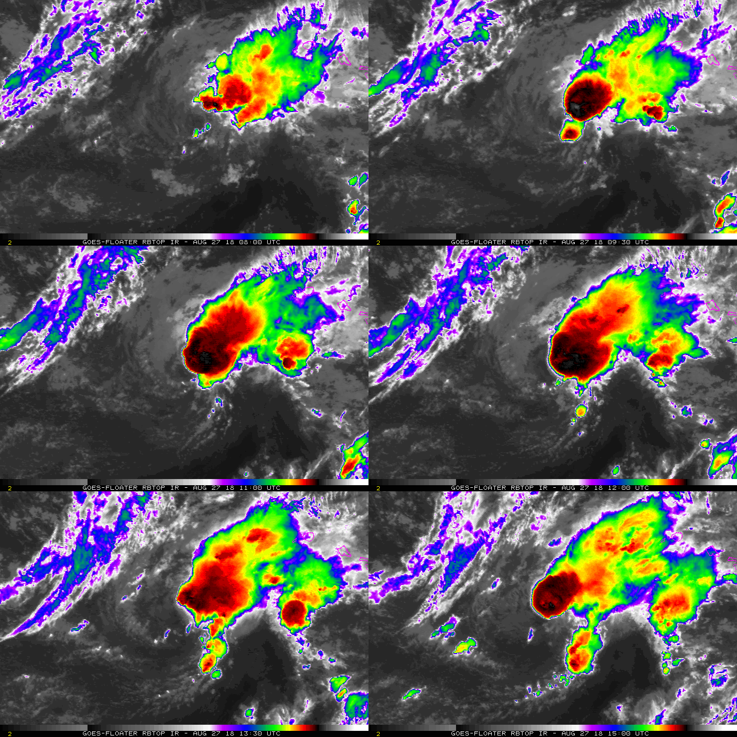
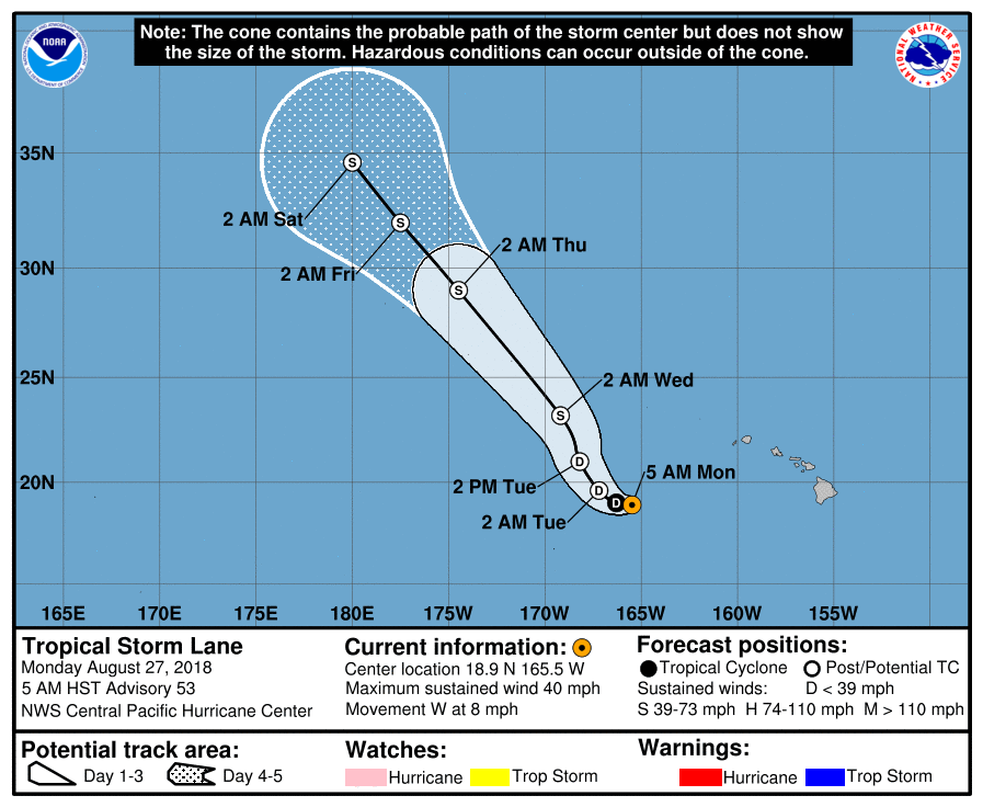
15Z報意外重回TS,但仍處於強風切區域,預報將馬上減弱回TD。
WTPA42 PHFO 271445
TCDCP2

Tropical Storm Lane Discussion Number  53
NWS Central Pacific Hurricane Center Honolulu HI   EP142018
500 AM HST Mon Aug 27 2018

Lane's low-level circulation center had been exposed for the better
part of the last 30 hours, as the cyclone remains in an environment
characterized by 40 kt of vertical wind shear. However, a recent
vigorous convective burst in the eastern semicircle has at least
partially obscured the low-level center, and convective banding has
increased to the southeast. Subjective Dvorak intensity estimates
trended up, but were still primarily 2.0/30 kt at the synoptic time,
while UW-CIMSS SATCON was near 35 kt. With the improved satellite
appearance since then, and since an ASCAT pass detected winds just
over 30 kt on Sunday, the initial intensity for this advisory is
increased to 35 kt, and Lane is once again a tropical storm.

The initial motion for this advisory is 270/7 kt, with Lane being
driven westward by a surface high to the distant northeast. This
motion will continue in the short-term, with Lane's forward motion
expected to diminish tonight as it reaches the southwestern edge of
the high. At the same time, increased interaction with an
amplifying mid-level low will likely lead to a deepening shear
profile, with the strong shear currently in the upper-levels
spreading to the mid-levels. This should be more effective in
interrupting Lane's low-level core, and Lane is expected to become a
post-tropical remnant low by Tuesday.

Lane is forecast to become an extratropical low later Tuesday into
Wednesday as it gets wrapped up into the circulation associated
with the mid-level low. This extratropical low could then bring
gale force winds to portions of the Papahanaumokuakea Marine
National Monument as it tracks north and northwest. The updated
track forecast has been shifted to the left of the previous,
especially in the later periods, to be better in line with GFEX. The
intensity forecast represents a blend of regional and global model
guidance.

FORECAST POSITIONS AND MAX WINDS

INIT  27/1500Z 18.9N 165.5W   35 KT  40 MPH
12H  28/0000Z 19.0N 166.3W   30 KT  35 MPH
24H  28/1200Z 19.6N 167.2W   25 KT  30 MPH...POST-TROP/REMNT LOW
36H  29/0000Z 21.0N 168.2W   30 KT  35 MPH...POST-TROP/REMNT LOW
48H  29/1200Z 23.2N 169.2W   35 KT  40 MPH...POST-TROP/EXTRATROP
72H  30/1200Z 29.0N 174.5W   40 KT  45 MPH...POST-TROP/EXTRATROP
96H  31/1200Z 32.0N 177.5W   40 KT  45 MPH...POST-TROP/EXTRATROP
120H  01/1200Z 34.6N 180.0E   40 KT  45 MPH...POST-TROP/EXTRATROP

$$
Forecaster Birchard
EP142018_5day_cone_with_line_53.png

rbtop-animated.gif
回復

使用道具 舉報

簽到天數: 3279 天

[LV.Master]伴壇終老

t02436|2018-8-28 14:28 | 顯示全部樓層
03Z再次降格TD,之後將會被風切徹底摧毀,無法進入西太。
WTPA42 PHFO 280255
TCDCP2

Tropical Depression Lane Discussion Number  55
NWS Central Pacific Hurricane Center Honolulu HI   EP142018
500 PM HST Mon Aug 27 2018

Visible imagery from Himawari continues to show an exposed low
level circulation center. The closest cold, high clouds associated
with Lane are over 90 nm northeast of the center. Subjective Dvorak
intensity estimates from HFO, SAB and JTWC were all 2.0/30 kt. The
initial intensity for this advisory has been lowered to 30 kt, and
Lane has been downgraded to a depression.

A strong east northeast to west southwest ridge north of Lane
has continued to steer the storm toward the west. The initial motion
for this advisory is 270/6 kt. Satellite water vapor loops show a
deep low aloft near 23N 172W. Southwest flow associated with this
low is producing strong southwest vertical wind shear over Lane. The
UM-CIMSS shear estimate was 51.2 kt.
The low aloft is forecast to
induce a deepening north south surface trough along 170W. The
weakening circulation of Lane will become part of this trough and
turn toward the north northwest tonight.

Lane is forecast to weaken to a post-tropical remnant low within 24
hours. The remnant low will continue to weaken as a new
extratropical low forms to the northwest. The remnants of Lane will
become wrapped up into that low.


FORECAST POSITIONS AND MAX WINDS

INIT  28/0300Z 18.5N 166.6W   30 KT  35 MPH
12H  28/1200Z 18.8N 167.5W   25 KT  30 MPH
24H  29/0000Z 19.5N 168.2W   25 KT  30 MPH...POST-TROP/REMNT LOW
36H  29/1200Z 20.9N 168.4W   25 KT  30 MPH...POST-TROP/REMNT LOW
48H  30/0000Z 22.0N 168.8W   20 KT  25 MPH...POST-TROP/REMNT LOW
72H  31/0000Z...DISSIPATED

$$
Forecaster Donaldson

EP142018_5day_cone_with_line_55.png

vis-animated.gif

20180828.0550.himawari-8.ircolor.14E.LANE.30kts.1007mb.18.4N.166.4W.100pc.jpg
回復

使用道具 舉報

簽到天數: 582 天

[LV.9]以壇為家II

蜜露|2018-9-5 10:44 | 顯示全部樓層


那陣子很忙,雷恩的巔峰不小心錯過了 = =

巔峰只剩這張圖保留而已。

20180822.0030.goes15.x.wv1km.14ELANE.135kts-941mb-142N-1527W.100pc.jpg


FNMOC刪除太可怕
回復

使用道具 舉報

123
快速回覆
您需要登錄後才可以回帖 登錄 | 立即加入

本版積分規則

本平台僅供學術討論之用,預報應以氣象局為準

威普網站虛擬主機贊助公司

臺灣第一個天氣類型社群平台 即時天氣資訊、精準颱風動態

線上客服
FB傳送訊息
廣告行銷
精準行銷 物超所值
官方粉專
發佈 快速回復 返回頂部 返回列表