開啟輔助訪問
 找回密碼
 立即加入

08L.Helene 西非熱帶波發展 洋面北上轉化溫氣 侵襲愛爾蘭

簽到天數: 601 天

[LV.9]以壇為家II

2018-9-7 09:12 | 顯示全部樓層
本帖最後由 霧峰追風者 於 2018-9-26 03:36 編輯

  二級颶風  
編號:06 L
名稱:Helene
800px-Helene_2018-09-11_1245Z.jpg
  基本資料  
擾動編號日期:2018 09 07 08
命名日期  :2018 09 08 11
撤編日期  :2018 09 16 23
登陸地點  :

  巔峰時期資料  
近中心最強風速 :95 kt
海平面最低氣壓 :966 百帕

  過去路徑圖  
1024px-Helene_2018_track.png
  擾動編號資料  
93L.INVEST.15kts-1005mb-13.0N-16.0W

20180907.0000.msg4.x.ir1km_bw.93LINVEST.20kts-1007mb-130N-160W.100pc.jpg

  NHC : 70%  
2. A tropical wave and an accompanying low pressure system near the
west coast of Africa is producing a large area of thunderstorms.
Environmental conditions appear conducive for development, and a
tropical depression or tropical storm is likely to form over the
weekend while the wave moves westward or west-northwestward over the
far eastern tropical Atlantic Ocean. Interests in the Cabo Verde
Islands should monitor the progress of this system, and potential
tropical cyclone advisories could be issued on Friday.
* Formation chance through 48 hours...high...70 percent.
* Formation chance through 5 days...high...90 percent.
two_atl_2d2.png

以上資料來自:NHC、颱風論壇整理製作

點評

氣壓打錯了,是966hpa而非928hpa  發表於 2018-9-15 23:44

評分

參與人數 1水氣能量 +15 +1 收起 理由
t02436 + 15 + 1

查看全部評分

回復

使用道具 舉報

簽到天數: 3279 天

[LV.Master]伴壇終老

t02436|2018-9-7 22:50 | 顯示全部樓層
中心已經出海,NHC升格08L潛在熱帶氣旋,上望60節。
616
WTNT43 KNHC 071437
TCDAT3

Potential Tropical Cyclone Eight Discussion Number   1
NWS National Hurricane Center Miami FL       AL082018
1100 AM AST Fri Sep 07 2018

Satellite imagery and surface observations indicate that the area of
low pressure that moved off the west coast of Africa has developed a
closed circulation that appears to be well defined. However, the
convective organization, given Dvorak classifications of only T1.0,
do not support calling the system a tropical cyclone at this point.
However, given that the system is expected to be a tropical storm
near the southern Cabo Verde Islands in 36 to 48 hours, advisories
are being initiated on this system as a potential tropical cyclone
at this time, and a tropical storm warning has been issued for those
islands.

Environmental conditions of light to moderate easterly shear and
SSTs of 27-28C should support development of this system, and the
NHC forecast shows it becoming a tropical storm by 12 hours.
Gradual strengthening is indicated by the bulk of the intensity
guidance through the next 3-4 days. After that time, the shear is
forecast to increase and the system will be moving into somewhat
cooler waters, so some weakening is expected by day 5. The NHC
forecast is close to the latest HCCA guidance and a little higher
than the IVCN consensus.

The initial motion estimate is a somewhat uncertain 275/09 given
that the surface circulation is just forming. The synoptic pattern
over the eastern Atlantic features a ridge to the north of the
disturbance, which is expected to weaken by the end of the period.
This steering pattern should result in a westward to west-
northwestward motion for the next 72 hours with an increase in
forward speed, followed by a decrease in forward speed and a
slightly more poleward motion as the system responds to the weakness
in the ridge. The initial NHC track forecast is close to the latest
HCCA track consensus aid and near the middle of the guidance
envelope.

FORECAST POSITIONS AND MAX WINDS

INIT  07/1500Z 13.1N  17.8W   30 KT  35 MPH...POTENTIAL TROP CYCLONE
12H  08/0000Z 13.3N  18.6W   35 KT  40 MPH...TROPICAL STORM
24H  08/1200Z 13.8N  20.3W   40 KT  45 MPH
36H  09/0000Z 14.2N  22.6W   45 KT  50 MPH
48H  09/1200Z 14.6N  25.4W   50 KT  60 MPH
72H  10/1200Z 16.0N  32.0W   55 KT  65 MPH
96H  11/1200Z 18.0N  37.0W   60 KT  70 MPH
120H  12/1200Z 20.0N  41.0W   55 KT  65 MPH

$$
Forecaster Brennan

143914_5day_cone_with_line.png

goes16_truecolor_93L_201809071435.jpg

goes16_ir_93L_201809071435.jpg
回復

使用道具 舉報

簽到天數: 601 天

[LV.9]以壇為家II

霧峰追風者|2018-9-8 08:31 | 顯示全部樓層
NHC 第2報判定為熱帶低壓,巔峰上望70KT。
413
WTNT43 KNHC 072046
TCDAT3

Tropical Depression Eight Discussion Number   2
NWS National Hurricane Center Miami FL       AL082018
500 PM AST Fri Sep 07 2018

Satellite data and surface observations indicate that the low
pressure system located just west of the coast of Africa has
developed into a tropical depression.  Conventional satellite
imagery shows a well-defined convective band has formed near the
center, and microwave satellite imagery has hinted at the formation
of an inner ring of convection.  The initial intensity of 30 kt
and the central pressure of 1002 mb are based on surface
observations from ships and the west coast of Africa. The depression
currently has good cirrus outflow in all directions.

The initial motion is 275/9.  During the next 3-4 days, the cyclone
should move generally west-northwestward with an increase in forward
speed on the south side of the subtropical ridge over the eastern
Atlantic.  Near the end of the forecast period, a developing mid- to
upper-level trough over the central Atlantic is expected to weaken
the ridge and allow the cyclone to turn northwestward with a
decrease in forward speed.  There is some spread in the guidance
late in the period, with the UKMET and the Canadian models showing
an earlier turn than the other models.   The new forecast track,
which is similar to the previous track, is in best agreement with
the TVCN and HCCA consensus models.

The depression is in an environment of light to moderate easterly
vertical shear and over sea surface temperatures of 27-28C.  This
should allow at least steady strengthening, and rapid strengthening
is possible based on the hints of the inner core in microwave
imagery.  This portion of the intensity forecast has been increased
to the upper edge of the intensity guidance, with the cyclone
forecast to become a tropical storm in 12 h or less and a hurricane
between 48-72 h.  After 72 h, the system should be over sea surface
temperatures near 26C and encountering southwesterly vertical shear
due to the aforementioned trough.  This should cause at least a
gradual weakening.

FORECAST POSITIONS AND MAX WINDS

INIT  07/2100Z 13.2N  18.6W   30 KT  35 MPH
12H  08/0600Z 13.5N  19.9W   35 KT  40 MPH
24H  08/1800Z 13.9N  21.9W   45 KT  50 MPH
36H  09/0600Z 14.4N  24.5W   55 KT  65 MPH
48H  09/1800Z 14.9N  27.5W   60 KT  70 MPH
72H  10/1800Z 16.5N  33.5W   70 KT  80 MPH
96H  11/1800Z 18.0N  38.5W   65 KT  75 MPH
120H  12/1800Z 20.5N  42.0W   60 KT  70 MPH

$$
Forecaster Beven
233206_5day_cone_no_line_and_wind.png avn-animated (2).gif

回復

使用道具 舉報

簽到天數: 601 天

[LV.9]以壇為家II

霧峰追風者|2018-9-8 11:37 | 顯示全部樓層
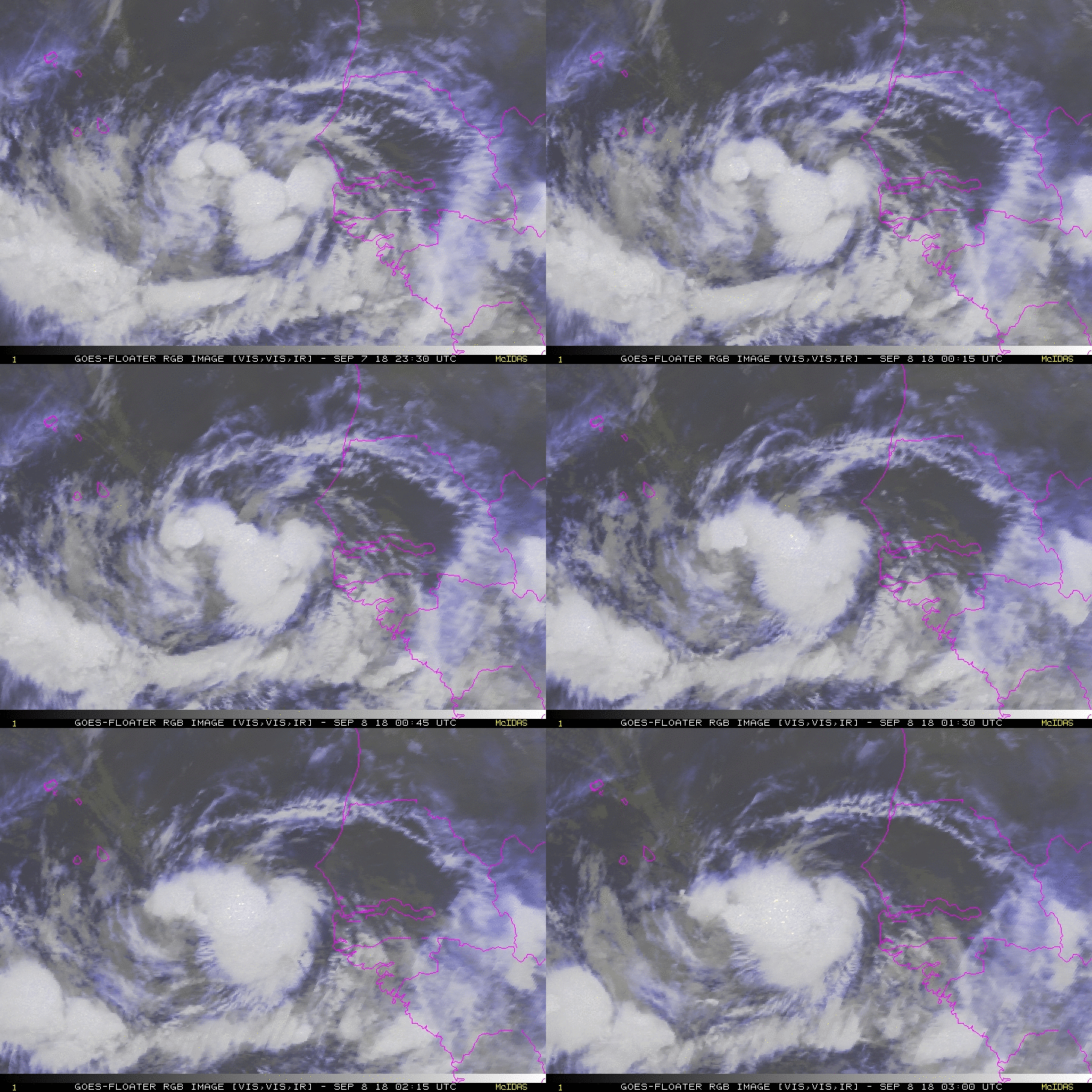
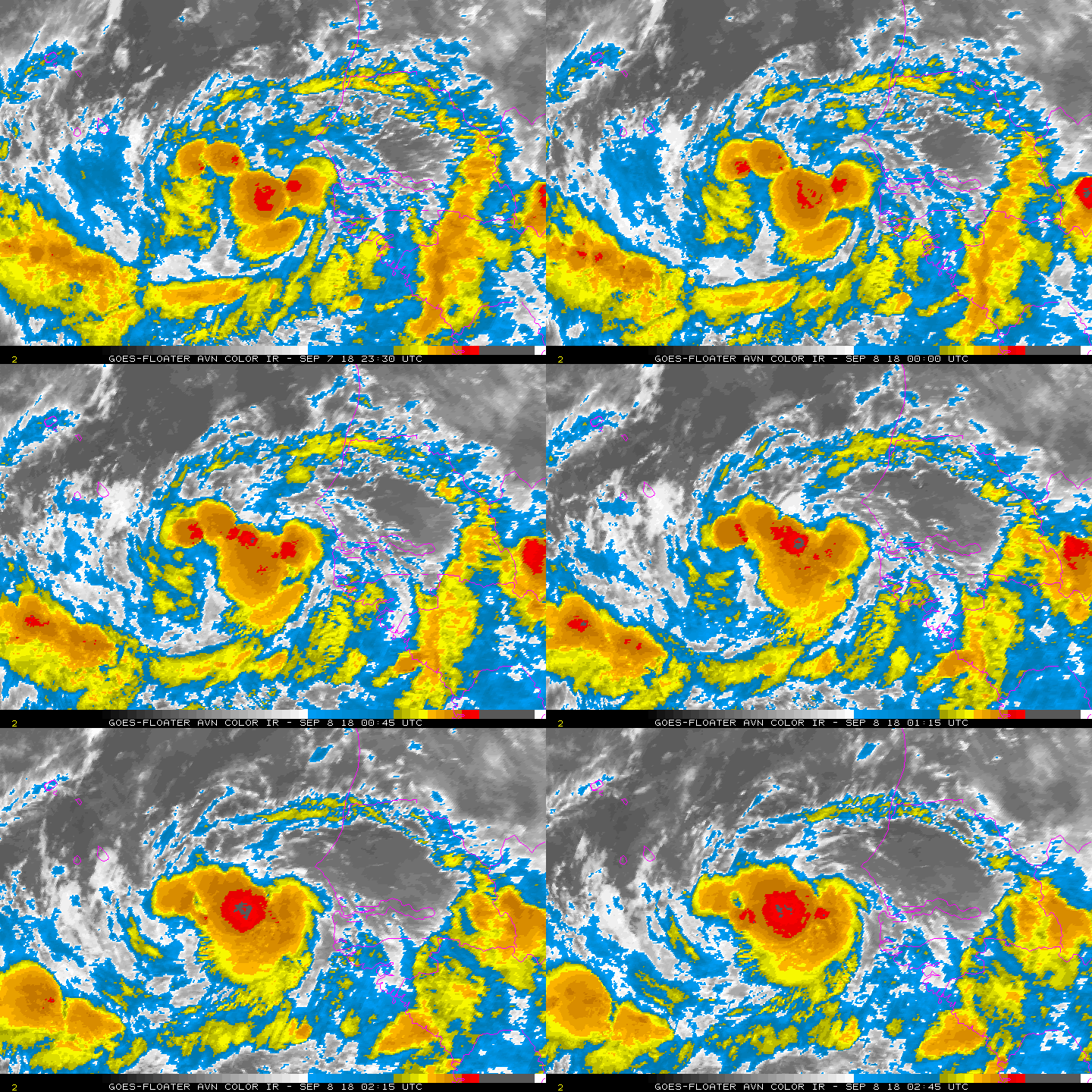
NHC 03Z命名"Helene"。
187
WTNT43 KNHC 080244
TCDAT3

Tropical Storm Helene Discussion Number   3
NWS National Hurricane Center Miami FL       AL082018
1100 PM AST Fri Sep 07 2018

A very timely ASCAT pass indicated that the winds associated with
the depression have increased to 35 kt, and also that the center was
a little east of the location previously indicated. This is very
common in systems during the formative stage.  Based on the ASCAT
data, the system has been upgraded to Tropical Storm Helene, the
eighth named storm of the season. The satellite presentation has
also improved during the past several hours, and now the cyclone has
large cyclonically curved convective bands to the south of the
center. The outflow is fair in all quadrants.

Helene will be moving over warm waters and within an environment
of light shear through the next 3 to 4 days, and most of the
guidance responds to that environment by gradually strengthening the
cyclone. The NHC forecast follows the trend of the intensity
consensus, and brings Helene to hurricane intensity in about 3 days.

Currently, Helene is embedded within a southwest monsoon-type flow,
and is moving toward the west at about 9 or 10 knots. However, as
the cyclone moves away from the African coast, it will become
steered by the easterly flow around the subtropical ridge and should
then increase in forward speed. Most of the track models are in
extremely good agreement, at least for the next 3 days when the
confidence in the forecast is high. At the long range, a mid-level
trough is expected to develop over the central Atlantic, forcing the
cyclone to turn more to the northwest and even north later on. The
NHC forecast is in the middle of the guidance envelope and basically
on top of the corrected consensus HCCA.


FORECAST POSITIONS AND MAX WINDS

INIT  08/0300Z 13.6N  18.5W   35 KT  40 MPH
12H  08/1200Z 13.8N  19.9W   35 KT  40 MPH
24H  09/0000Z 14.3N  22.3W   40 KT  45 MPH
36H  09/1200Z 14.8N  25.0W   50 KT  60 MPH
48H  10/0000Z 15.4N  28.0W   55 KT  65 MPH
72H  11/0000Z 17.0N  33.9W   65 KT  75 MPH
96H  12/0000Z 18.5N  39.0W   65 KT  75 MPH
120H  13/0000Z 20.5N  42.5W   60 KT  70 MPH

$$
Forecaster Avila
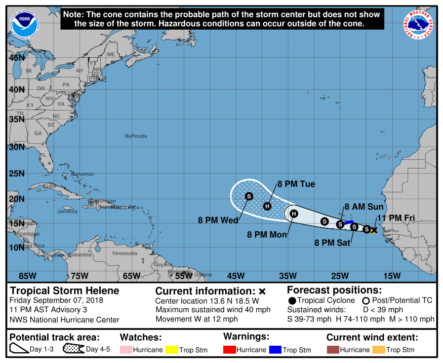
024610_5day_cone_no_line_and_wind.png rgb-animated.gif avn-animated (3).gif

回復

使用道具 舉報

簽到天數: 601 天

[LV.9]以壇為家II

霧峰追風者|2018-9-10 05:51 | 顯示全部樓層
NHC 強度升一級颶風,巔峰上望90節。
354
WTNT43 KNHC 092032
TCDAT3

Hurricane Helene Discussion Number  10
NWS National Hurricane Center Miami FL       AL082018
500 PM AST Sun Sep 09 2018

Deep convection has increased in coverage and intensity over the
southern portion of the circulation, and microwave imagery suggests
that an inner core is beginning to develop.  Helene's maximum
winds are boosted to hurricane strength, 65 kt, based on Dvorak
Current Intensity numbers from SAB and TAFB.  The cyclone should
continue to traverse warm waters and be in a low-shear environment
for the next couple of days.  Therefore, additional intensification
is called for during the next 48 hours.  Afterwards, increasing
south-southwesterly shear should cause gradual weakening.  The
official intensity forecast is close to the model consensus, IVCN.

Helene is moving just north of due west, or 280/11 kt.  There are no
significant changes to the track forecast philosophy for this
advisory.  Helene should move generally west-northwestward along
the south side of a weak mid-level ridge for the next couple of
days.  After that, a mid-level trough digging along 40W-45W
longitude should induce a turn toward the northwest and eventually
north.  The official track forecast is very similar to the one from
the previous cycle through 72 hours, and is nudged a little to the
east after that time.  This is fairly close to the latest corrected
consensus guidance, HCCA.

FORECAST POSITIONS AND MAX WINDS

INIT  09/2100Z 13.4N  26.0W   65 KT 75 MPH
12H  10/0600Z 13.9N  28.1W   75 KT  85 MPH
24H  10/1800Z 14.5N  30.8W   85 KT 100 MPH
36H  11/0600Z 15.2N  33.3W   90 KT 105 MPH
48H  11/1800Z 15.9N  35.5W   90 KT 105 MPH
72H  12/1800Z 18.0N  38.6W   80 KT  90 MPH
96H  13/1800Z 21.5N  40.5W   65 KT  75 MPH
120H  14/1800Z 27.5N  41.5W   55 KT  65 MPH

$$

Forecaster Pasch
203552_5day_cone_no_line_and_wind.png rgb-animated (2).gif rbtop-animated (3).gif

回復

使用道具 舉報

簽到天數: 601 天

[LV.9]以壇為家II

霧峰追風者|2018-9-11 14:08 | 顯示全部樓層
強度升二級颶風,預計已經到達顛峰,逐漸轉向北上。
809
WTNT43 KNHC 110242
TCDAT3

Hurricane Helene Discussion Number  15
NWS National Hurricane Center Miami FL       AL082018
1100 PM AST Mon Sep 10 2018

Helene remains a well organized hurricane with a fairly large 25 n
mi diameter eye and ring of cold cloud tops surrounding that
feature.  There are a few dry slots beyond the inner core, however,
which have prevented some of the Dvorak estimates from increasing
this cycle.  A blend of the latest subjective and objective
satellite intensity estimates supports raising the initial intensity
slightly to 95 kt.

The hurricane has a limited amount of time to strengthen as the
current environment of low wind shear and relatively warm SSTs will
be changing soon.  Helene is expected to cross the 26 deg C isotherm
within 24 hours and it will enter an environment of increasing
south-southwesterly shear just beyond that time period.  These
conditions should promote a steady weakening trend beginning late
Tuesday.  By the end of the forecast period, however, SSTs increase
along the forecast track, and there could be some baroclinic
enhancements to end the weakening trend and perhaps even cause some
strengthening.  This scenario is supported by the HWRF/HMON regional
models and the GFS/ECMWF global models.  The NHC intensity forecast
is largely an update of the previous one, except it is slightly
higher at the end of the period.

The hurricane is gradually turning to the right, with the latest
initial motion estimate being 295/13 kt.  A large mid- to
upper-level trough over the north Atlantic is expected to dig
southward causing a significant weakness in the subtropical ridge.
In response to this change in the steering pattern, Helene is
forecast to gradually turn northward and then north-northeastward
during the next several days.  The track models are in fairly good
agreement, and the NHC track forecast lies near the middle of the
guidance envelope.  This forecast is only a little to the right of
the previous track.

FORECAST POSITIONS AND MAX WINDS

INIT  11/0300Z 15.5N  32.4W   95 KT 110 MPH
12H  11/1200Z 16.2N  34.0W   95 KT 110 MPH
24H  12/0000Z 17.2N  35.7W   85 KT 100 MPH
36H  12/1200Z 18.6N  37.2W   75 KT  85 MPH
48H  13/0000Z 20.1N  38.0W   65 KT  75 MPH
72H  14/0000Z 24.6N  39.0W   60 KT  70 MPH
96H  15/0000Z 30.0N  38.0W   50 KT  60 MPH
120H  16/0000Z 36.2N  34.0W   55 KT  65 MPH

$$
Forecaster Cangialosi
024644_5day_cone_no_line_and_wind.png 20180911.0530.msg-4.ir.08L.HELENE.90kts.974mb.15.3N.31.9W.100pc.jpg rgb-animated (5).gif rbtop-animated (6).gif

回復

使用道具 舉報

簽到天數: 3279 天

[LV.Master]伴壇終老

t02436|2018-9-17 00:50 | 顯示全部樓層
NHC判定轉化為溫帶氣旋,明天影響英國。
ZCZC MIATCDAT3 ALL
TTAA00 KNHC DDHHMM

Post-Tropical Cyclone Helene Discussion Number  37
NWS National Hurricane Center Miami FL       AL082018
1100 AM AST Sun Sep 16 2018

Helene's cloud pattern has transformed into that of an
extratropical cyclone,
with a large area of cold cloud tops
located well to the north and northwest of the center.  An ASCAT
pass that caught the eastern portion of the circulation revealed
maximum winds of 40 to 45 kt, therefore the initial wind speed
remains 45 kt for this advisory.  The global models suggest that
the system will strengthen slightly today due to baroclinic
processes, and this is reflected in the official forecast.
Weakening is anticipated by late Monday, and the system is forecast
to be absorbed by a larger low pressure to the northwest of the
United Kingdom by Tuesday morning.

The cyclone is moving quickly northeastward or 055/25 kt.  Now that
the system is embedded within the mid-latitude westerlies, a
northeastward motion with some additional increase in forward speed
is expected over the next day or so.  The global models remain in
good agreement on the track of the post-tropical low, and the new
official forecast is an update of the previous advisory.

This is the last NHC advisory on this system.  Interests in Ireland
and the United Kingdom should consult products from their local
meteorological service for information about potential impacts from
the post-tropical cyclone.  Local forecasts and warnings for the UK
can be found on the website of the UK Met Office at
https://www.metoffice.gov.uk/. Local forecasts and warnings for
Ireland can be found on the website of Met Eireann
at https://www.met.ie/.

FORECAST POSITIONS AND MAX WINDS

INIT  16/1500Z 43.8N  25.7W   45 KT  50 MPH...POST-TROPICAL
12H  17/0000Z 45.8N  21.2W   50 KT  60 MPH...POST-TROP/EXTRATROP
24H  17/1200Z 49.0N  14.8W   50 KT  60 MPH...POST-TROP/EXTRATROP
36H  18/0000Z 52.8N   6.2W   40 KT  45 MPH...POST-TROP/EXTRATROP
48H  18/1200Z...ABSORBED

$$
Forecaster Brown

08L.png

vis-animated.gif
回復

使用道具 舉報

快速回覆
您需要登錄後才可以回帖 登錄 | 立即加入

本版積分規則

本平台僅供學術討論之用,預報應以氣象局為準

威普網站虛擬主機贊助公司

臺灣第一個天氣類型社群平台 即時天氣資訊、精準颱風動態

線上客服
FB傳送訊息
廣告行銷
精準行銷 物超所值
官方粉專
發佈 快速回復 返回頂部 返回列表