開啟輔助訪問
 找回密碼
 立即加入

92L

簽到天數: 1650 天

[LV.Master]伴壇終老

2019-9-2 17:23 | 顯示全部樓層
  基本資料  
編號    :92 L
擾動編號日期:2019 09 02 16
撤編日期  :2019 09 07 05
92L INVEST 190902 0600 30.0N 59.9W ATL 30 1011

174412fvzui5hj50t14uyx.jpg

  NHC:30%  
3. A trough of low pressure is located several hundred miles
south-southeast of Bermuda.  Shower and thunderstorm activity has
increased since yesterday and has also become better organized this
morning.  Gradual development of this system is possible during
the next few days while the disturbance moves slowly northward or
north-northwestward. Interests in and around Bermuda should monitor
the progress of this disturbance.
* Formation chance through 48 hours...low...30 percent.
* Formation chance through 5 days...medium...50 percent.

two_atl_2d30902.png two_atl_5d30902.png

評分

參與人數 1水氣能量 +15 +1 收起 理由
king111807 + 15 + 1 熱帶擾動首帖

查看全部評分

回復

使用道具 舉報

簽到天數: 601 天

[LV.9]以壇為家II

霧峰追風者|2019-9-3 09:53 | 顯示全部樓層
展望維持在30%。
3. A trough of low pressure, located several hundred miles
south-southeast of Bermuda, is producing disorganized showers and
thunderstorms.  Some gradual development of the disturbance is
possible during the next couple of days.  Afterward, upper-level
winds are forecast to become less favorable for tropical cyclone
formation.  Interests in Bermuda should monitor the progress of this
disturbance.
* Formation chance through 48 hours...low...30 percent.
* Formation chance through 5 days...medium...30 percent.
two_atl_2d3.png
回復

使用道具 舉報

簽到天數: 601 天

[LV.9]以壇為家II

霧峰追風者|2019-9-3 20:41 | 顯示全部樓層
展望提升至40%。
2. A trough of low pressure, located several hundred miles south of
Bermuda, is producing disorganized showers and thunderstorms.  Some
development of the disturbance is possible during the next couple of
days while the system moves northward, and a tropical depression
could form by Thursday.  Afterward, upper-level winds are forecast
to become less favorable for tropical cyclone formation. Interests
in Bermuda should monitor the progress of this system, and areas of
heavy rainfall are likely.
* Formation chance through 48 hours...medium...40 percent.
* Formation chance through 5 days...medium...40 percent
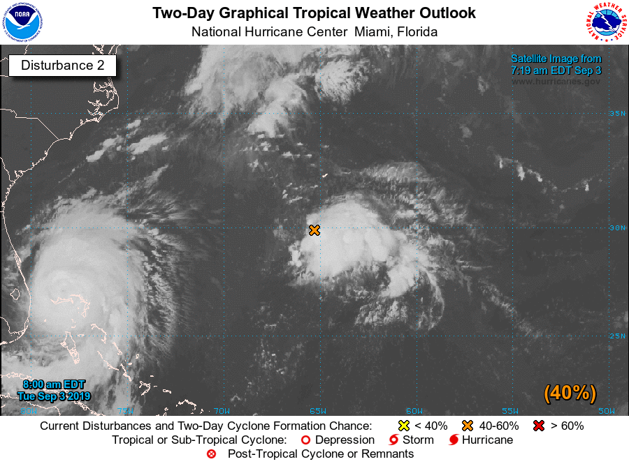
two_atl_2d2.png

回復

使用道具 舉報

簽到天數: 601 天

[LV.9]以壇為家II

霧峰追風者|2019-9-5 11:13 | 顯示全部樓層
稍早展望提升至60%,對流鬆散。
1. A small area of low pressure located about 200 miles northeast of
Bermuda is producing showers and thunderstorms well to the southeast
of the center. Only a small decrease in the upper level winds could
result in the formation of a tropical depression in the next day or
so. However, by Saturday upper-level winds are forecast to increase
even further, making conditions unfavorable for tropical cyclone
formation.
* Formation chance through 48 hours...medium...60 percent.
* Formation chance through 5 days...medium...60 percent.
two_atl_2d1.png
回復

使用道具 舉報

簽到天數: 1650 天

[LV.Master]伴壇終老

老農民版夜神月|2019-9-6 03:53 | 顯示全部樓層
NHC展望降低至Low,10%
A small area of low pressure located a few hundred miles northeast
of Bermuda is producing limited showers and thunderstorms, well to
the southeast of the center. This system has become poorly defined
and significant development is not anticipated.
* Formation chance through 48 hours...low...10 percent.
* Formation chance through 5 days...low...10 percent.
two_atl_2d0904.png two_atl_5d0904.png


回復

使用道具 舉報

快速回覆
您需要登錄後才可以回帖 登錄 | 立即加入

本版積分規則

本平台僅供學術討論之用,預報應以氣象局為準

威普網站虛擬主機贊助公司

臺灣第一個天氣類型社群平台 即時天氣資訊、精準颱風動態

線上客服
FB傳送訊息
廣告行銷
精準行銷 物超所值
官方粉專
發佈 快速回復 返回頂部 返回列表