開啟輔助訪問
 找回密碼
 立即加入

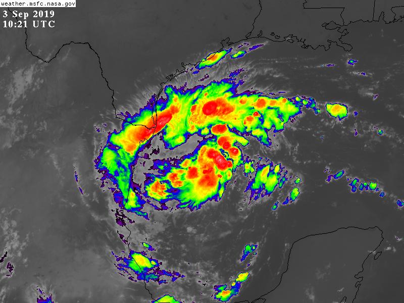
07L.Fernand 短暫發展 登陸墨西哥東岸

簽到天數: 1650 天

[LV.Master]伴壇終老

2019-9-2 20:51 | 顯示全部樓層
  熱帶風暴  
編號:07 L
名稱:Fernand

  基本資料  
擾動編號日期:2019 09 02 20
命名日期  :2019 09 04 02
撤編日期  :2019 09 06 09
登陸地點  :墨西哥

  巔峰時期資料  
近中心最強風速 :45 kt
海平面最低氣壓 :1000 百帕

  過去路徑圖  

  擾動編號資料  
93L INVEST 190902 1200 24.5N 92.0W ATL 20 1008

205239j4ru6lnafr350emc.jpg GOES12302019245Fn5GcG.jpg

  NHC:40%  
2. A broad area of low pressure located over the south-central Gulf of
Mexico is producing a wide area of showers and thunderstorms. This
system has become better organized since yesterday, and a tropical
depression could form during the next few days while the low moves
slowly westward across the south-central and southwestern Gulf of
Mexico toward the coast of Mexico.
* Formation chance through 48 hours...medium...40 percent.
* Formation chance through 5 days...medium...50 percent.

two_atl_2d2902.png two_atl_5d2902.png

以上資料來自:NHC、颱風論壇整理製作

評分

參與人數 1水氣能量 +15 +1 收起 理由
king111807 + 15 + 1 熱帶擾動首帖

查看全部評分

回復

使用道具 舉報

簽到天數: 601 天

[LV.9]以壇為家II

霧峰追風者|2019-9-3 08:54 | 顯示全部樓層
展望提升至60%。
2. An extensive area of showers and thunderstorms continues in
association with an area of low pressure located over the
south-central Gulf of Mexico.  Environmental conditions appear
conducive for additional development, and a tropical depression is
likely to form during the next few days while the low moves
slowly westward or west-southwestward toward the coast of Mexico.
Interests along the northeast coast of Mexico should monitor the
progress of this system.
* Formation chance through 48 hours...medium...60 percent.
* Formation chance through 5 days...high...70 percent.

two_atl_2d2.png
回復

使用道具 舉報

簽到天數: 601 天

[LV.9]以壇為家II

霧峰追風者|2019-9-3 14:03 | 顯示全部樓層
展望提升至80%。
2. Showers and thunderstorms associated with a large low pressure
system located over the west-central Gulf of Mexico about 200 miles
east-northeast of Tampico, Mexico, is showing signs of organization.
Environmental conditions are conducive for a tropical depression to
form during the next day or so while the low moves slowly westward
or west-southwestward toward Mexico.  Interests along the
northeastern coast of Mexico should monitor the progress of this
system.  A NOAA reconnaissance aircraft is scheduled to investigate
the disturbance this afternoon, if necessary.
* Formation chance through 48 hours...high...80 percent.
* Formation chance through 5 days...high...80 percent.
two_atl_2d2.png
回復

使用道具 舉報

簽到天數: 1650 天

[LV.Master]伴壇終老

老農民版夜神月|2019-9-3 18:32 | 顯示全部樓層
NHC03/09Z一報升格Potential TC Seven,07L
000
WTNT42 KNHC 030909
TCDAT2

Potential Tropical Cyclone Seven Discussion Number   1
NWS National Hurricane Center Miami FL       AL072019
400 AM CDT Tue Sep 03 2019

Overnight scatterometer wind data and infrared satellite imagery
indicate that the broad low pressure system located over the
west-central and southwestern Gulf of Mexico is gradually becoming
better defined, but still lacks a well-defined center. However, the
scatterometer indicated surface winds of 30-33 kt in the
northwestern quadrant and observations from Buoy 42002 north of the
center have been indicating wind speeds of 25-27 kt at 4-meter
elevation. Based on these data, advisories are being initiated on
Potential Cyclone Seven. The initial motion estimate is an uncertain
260/06 kt. The general motion of the broad low is expected to be
westward, being steered by a deep-layer ridge located over the
southern United States. It is possible, however, that an apparent
west-northwestward motion could occur if the low-level center
redevelops farther north into the deep convection. The NHC forecast
track is similar to, but a little north of, the consensus model
TVCN.

Some slight strengthening is forecast during then next 36-48 hours
before the low moves inland over northeastern Mexico. However, the
broad and large circulation should prevent any rapid intensification
from occurring. The official intensity forecast is similar to the
IVCN consensus model.

The primary threat from this system will be heavy rainfall that
could produce flooding and mudslides, especially in mountainous
areas.

FORECAST POSITIONS AND MAX WINDS

INIT  03/0900Z 23.5N  94.3W   30 KT  35 MPH...POTENTIAL TROP CYCLONE
12H  03/1800Z 23.4N  95.2W   30 KT  35 MPH...TROPICAL DEPRESSION
24H  04/0600Z 23.4N  96.3W   35 KT  40 MPH
36H  04/1800Z 23.7N  97.1W   40 KT  45 MPH
48H  05/0600Z 24.3N  98.2W   30 KT  35 MPH...INLAND
72H  06/0600Z...DISSIPATED

$$
Forecaster Stewart
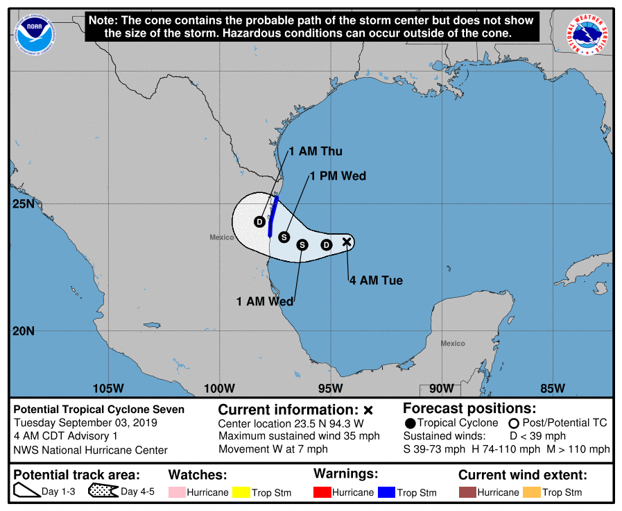
090134_5day_cone_no_line_and_wind.png 20190903.0950.goes-16.ir.07L.SEVEN.30kts.1006mb.23.6N.94W.100pc.jpg
GOES10212019246eFY4rT.jpg

回復

使用道具 舉報

簽到天數: 601 天

[LV.9]以壇為家II

霧峰追風者|2019-9-3 18:32 | 顯示全部樓層
升格潛在熱帶氣旋7L,直撲墨西哥東岸。
000
WTNT42 KNHC 030909
TCDAT2

Potential Tropical Cyclone Seven Discussion Number   1
NWS National Hurricane Center Miami FL       AL072019
400 AM CDT Tue Sep 03 2019

Overnight scatterometer wind data and infrared satellite imagery
indicate that the broad low pressure system located over the
west-central and southwestern Gulf of Mexico is gradually becoming
better defined, but still lacks a well-defined center. However, the
scatterometer indicated surface winds of 30-33 kt in the
northwestern quadrant and observations from Buoy 42002 north of the
center have been indicating wind speeds of 25-27 kt at 4-meter
elevation. Based on these data, advisories are being initiated on
Potential Cyclone Seven. The initial motion estimate is an uncertain
260/06 kt. The general motion of the broad low is expected to be
westward, being steered by a deep-layer ridge located over the
southern United States. It is possible, however, that an apparent
west-northwestward motion could occur if the low-level center
redevelops farther north into the deep convection. The NHC forecast
track is similar to, but a little north of, the consensus model
TVCN.

Some slight strengthening is forecast during then next 36-48 hours
before the low moves inland over northeastern Mexico. However, the
broad and large circulation should prevent any rapid intensification
from occurring. The official intensity forecast is similar to the
IVCN consensus model.

The primary threat from this system will be heavy rainfall that
could produce flooding and mudslides, especially in mountainous
areas.

FORECAST POSITIONS AND MAX WINDS

INIT  03/0900Z 23.5N  94.3W   30 KT  35 MPH...POTENTIAL TROP CYCLONE
12H  03/1800Z 23.4N  95.2W   30 KT  35 MPH...TROPICAL DEPRESSION
24H  04/0600Z 23.4N  96.3W   35 KT  40 MPH
36H  04/1800Z 23.7N  97.1W   40 KT  45 MPH
48H  05/0600Z 24.3N  98.2W   30 KT  35 MPH...INLAND
72H  06/0600Z...DISSIPATED

$$
Forecaster Stewart
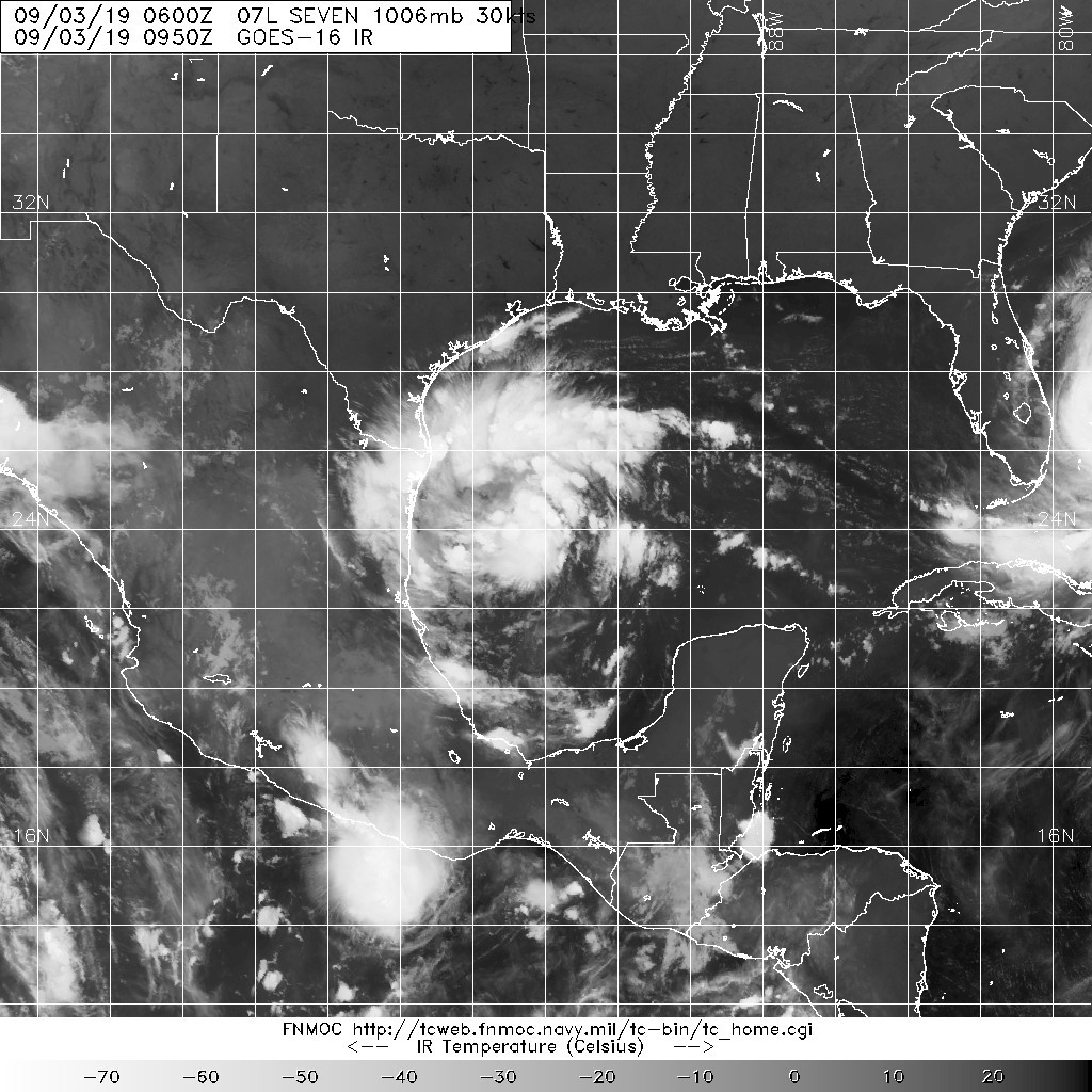
090134_5day_cone_no_line_and_wind.png

回復

使用道具 舉報

簽到天數: 1650 天

[LV.Master]伴壇終老

老農民版夜神月|2019-9-4 00:15 | 顯示全部樓層
本帖最後由 老農民版夜神月 於 2019-9-4 00:20 編輯

NHC03/15Z報正式升格07L為TD
WTNT42 KNHC 031444
TCDAT2

Tropical Depression Seven Discussion Number   2
NWS National Hurricane Center Miami FL       AL072019
1000 AM CDT Tue Sep 03 2019

First-light visible imagery indicates that the circulation of the
low pressure area in the western Gulf of Mexico has become better
defined, and that the system has sufficient organized convection to
be designated a tropical depression.  The initial intensity of 30 kt
is based mainly on persistence from earlier scatterometer data.

The initial motion is 260/6.  A deep-layer ridge over the southern
United States is expected to steer the cyclone generally westward
to west-northwestward through its lifetime.  The new forecast track
is between the HCCA and the TVCA consensus models and calls for the
center to reach the northeastern coast of Mexico in about 36 h.
The new track is shifted a little to the north of the previous
track, but not significantly far enough to increase the threat to
south Texas.

Conditions appear conducive for gradual strengthening before the
cyclone moves into Mexico.  However, the broad and large nature of
the circulation is likely to prevent rapid intensification before
landfall.  The new intensity forecast is an update of the previous
forecast and calls for the system to become a tropical storm before
reaching Mexico, followed by dissipation over northeastern Mexico
by 72 h.

The primary threat from this system will be heavy rainfall that
could produce flooding and mudslides, especially in the mountainous
areas of Mexico.


FORECAST POSITIONS AND MAX WINDS

INIT  03/1500Z 23.6N  94.9W   30 KT  35 MPH
12H  04/0000Z 23.4N  95.6W   30 KT  35 MPH
24H  04/1200Z 23.6N  96.7W   35 KT  40 MPH
36H  05/0000Z 24.1N  97.6W   40 KT  45 MPH
48H  05/1200Z 24.8N  98.5W   30 KT  35 MPH...INLAND
72H  06/1200Z...DISSIPATED

$$
Forecaster Beven

144929_5day_cone_no_line_and_wind.png 20190903.1520.goes-16.ir.07L.SEVEN.30kts.1004mb.23.6N.94.6W.100pc.jpg
20190903.1230.f17.ir.goes-16ir.07L.SEVEN.30kts.1004mb.23.6N.94.6W.040pc.jpg GOES16112019246EyRilI.jpg

回復

使用道具 舉報

簽到天數: 1650 天

[LV.Master]伴壇終老

老農民版夜神月|2019-9-4 02:50 | 顯示全部樓層
本帖最後由 老農民版夜神月 於 2019-9-4 02:52 編輯

NHC18Z升格07L為TS,並命名Fernand
791
WTNT32 KNHC 031749
TCPAT2

BULLETIN
Tropical Storm Fernand Intermediate Advisory Number 2A
NWS National Hurricane Center Miami FL       AL072019
100 PM CDT Tue Sep 03 2019

...DEPRESSION STRENGTHENS INTO TROPICAL STORM FERNAND...


SUMMARY OF 100 PM CDT...1800 UTC...INFORMATION
----------------------------------------------
LOCATION...23.5N 95.3W
ABOUT 160 MI...255 KM E OF LA PESCA MEXICO
ABOUT 185 MI...295 KM ENE OF TAMPICO MEXICO
MAXIMUM SUSTAINED WINDS...40 MPH...65 KM/H
PRESENT MOVEMENT...W OR 260 DEGREES AT 7 MPH...11 KM/H
MINIMUM CENTRAL PRESSURE...1004 MB...29.65 INCHES

two_atl_0d0.png 20190903.1800.goes-16.ir.07L.SEVEN.30kts.1004mb.23.6N.94.6W.100pc.jpg
GOES18362019246fbzf2i.jpg
回復

使用道具 舉報

簽到天數: 601 天

[LV.9]以壇為家II

霧峰追風者|2019-9-5 08:55 | 顯示全部樓層
中心登陸,減弱為TD,逐漸消散。
000
WTNT42 KNHC 042033
TCDAT2

Tropical Depression Fernand Discussion Number   7
NWS National Hurricane Center Miami FL       AL072019
400 PM CDT Wed Sep 04 2019

Fernand moved inland a few hours ago, and the surface center is
already showing signs of becoming poorly defined. The intensity is
now estimated at 30 kt, assuming weakening has occurred since the
cyclone moved inland. This makes Fernand a Tropical Depression. The
depression should move westward or west-northwestward for the next
12 h or so while it continues to weaken, and it could dissipate as
soon as tonight.

Although the winds have decreased and the depression will likely
dissipate soon, Fernand is still producing substantial convection
and continues to pose a significant rain threat to northeast Mexico.
Life-threatening flash floods and mudslides will be possible through
Thursday, even after Fernand dissipates. Please consult products
from you local weather service for more information on the potential
rainfall hazard.


FORECAST POSITIONS AND MAX WINDS

INIT  04/2100Z 24.4N  98.3W   30 KT  35 MPH
12H  05/0600Z 25.0N 100.0W   25 KT  30 MPH
24H  05/1800Z...DISSIPATED

$$
Forecaster Zelinsky
203434_5day_cone_no_line_and_wind.png
回復

使用道具 舉報

快速回覆
您需要登錄後才可以回帖 登錄 | 立即加入

本版積分規則

本平台僅供學術討論之用,預報應以氣象局為準

威普網站虛擬主機贊助公司

臺灣第一個天氣類型社群平台 即時天氣資訊、精準颱風動態

線上客服
FB傳送訊息
廣告行銷
精準行銷 物超所值
官方粉專
發佈 快速回復 返回頂部 返回列表