開啟輔助訪問
 找回密碼
 立即加入

02E.Amanda→03L.Cristobal 近岸命名即登陸瓜國 後於墨灣再度命名

簽到天數: 1650 天

[LV.Master]伴壇終老

老農民版夜神月|2020-6-3 01:35 | 顯示全部樓層
經由實測,NHC升格03L為TS,命名Cristobal
119
WTNT63 KNHC 021626 CCB
TCUAT3

Tropical Storm Cristobal Tropical Cyclone Update
NWS National Hurricane Center Miami FL       AL032020
1115 AM CDT Jun 02 2020

Corrected storm ID in header

...DEPRESSION STRENGTHENS TO A TROPICAL STORM...

Observations from an Air Force Reserve Unit Hurricane Hunter
aircraft indicate that Tropical Depression Three has strengthened
into Tropical Storm Cristobal.  The maximum winds are estimated to
be 40 mph (65 km/h) with higher gusts.

SUMMARY OF 1115 AM CDT...1615 UTC...INFORMATION
----------------------------------------------
LOCATION...19.3N 92.7W
ABOUT 150 MI...245 KM WSW OF CAMPECHE MEXICO
ABOUT 135 MI...215 KM NE OF COATZACOALCOS MEXICO
MAXIMUM SUSTAINED WINDS...40 MPH...65 KM/H
PRESENT MOVEMENT...SW OR 230 DEGREES AT 3 MPH...6 KM/H
MINIMUM CENTRAL PRESSURE...1004 MB...29.65 INCHES

$$
Forecaster Pasch

two_atl_0d0.png GOES17212020154IfrJpC.jpg
03L_gefs_latest.png goes16_ir_03L_202006021612.gif
回復

使用道具 舉報

簽到天數: 1650 天

[LV.Master]伴壇終老

老農民版夜神月|2020-6-4 10:21 | 顯示全部樓層
本帖最後由 老農民版夜神月 於 2020-6-4 13:27 編輯

Cristobal於命名後便開始在墨西哥灣南端打轉,並於昨晚再度進入中美洲陸地
NHC與數值預報均認為03L.Cristobal將於陸上持續緩慢移動兩天,而後進入墨西哥灣重新發展增強,並以巔峰強度登陸美國
al032020.20200604033208.gif 20200604.0130.goes-16.ir.03L.CRISTOBAL.40kts.995mb.18.3N.91.8W.100pc.jpg
20200604.0101.f17.x.colorpct_91h_91v_1deg.03LCRISTOBAL.40kts-995mb-183N-918W.059pc.jpg 03L_intensity_latest.png
03L_gefs_latest.png

回復

使用道具 舉報

簽到天數: 1650 天

[LV.Master]伴壇終老

老農民版夜神月|2020-6-6 01:03 | 顯示全部樓層
進入中美洲陸地徘徊兩天後,03L即將於今日早晨出海,至墨西哥灣稍作發展後北上直襲美國路易斯安那州
al032020.20200605153252.gif 145021_5day_cone_no_line_and_wind.png
20200605.1610.goes-16.vis.2km.03L.CRISTOBAL.30kts.1000mb.19.5N.90W.pc.jpg 20200605.1321.f17.composite.03L.CRISTOBAL.30kts.1000mb.19.5N.90W.055pc.jpg
GOES16312020157zH0bAx.jpg
回復

使用道具 舉報

簽到天數: 1650 天

[LV.Master]伴壇終老

老農民版夜神月|2020-6-7 19:03 | 顯示全部樓層
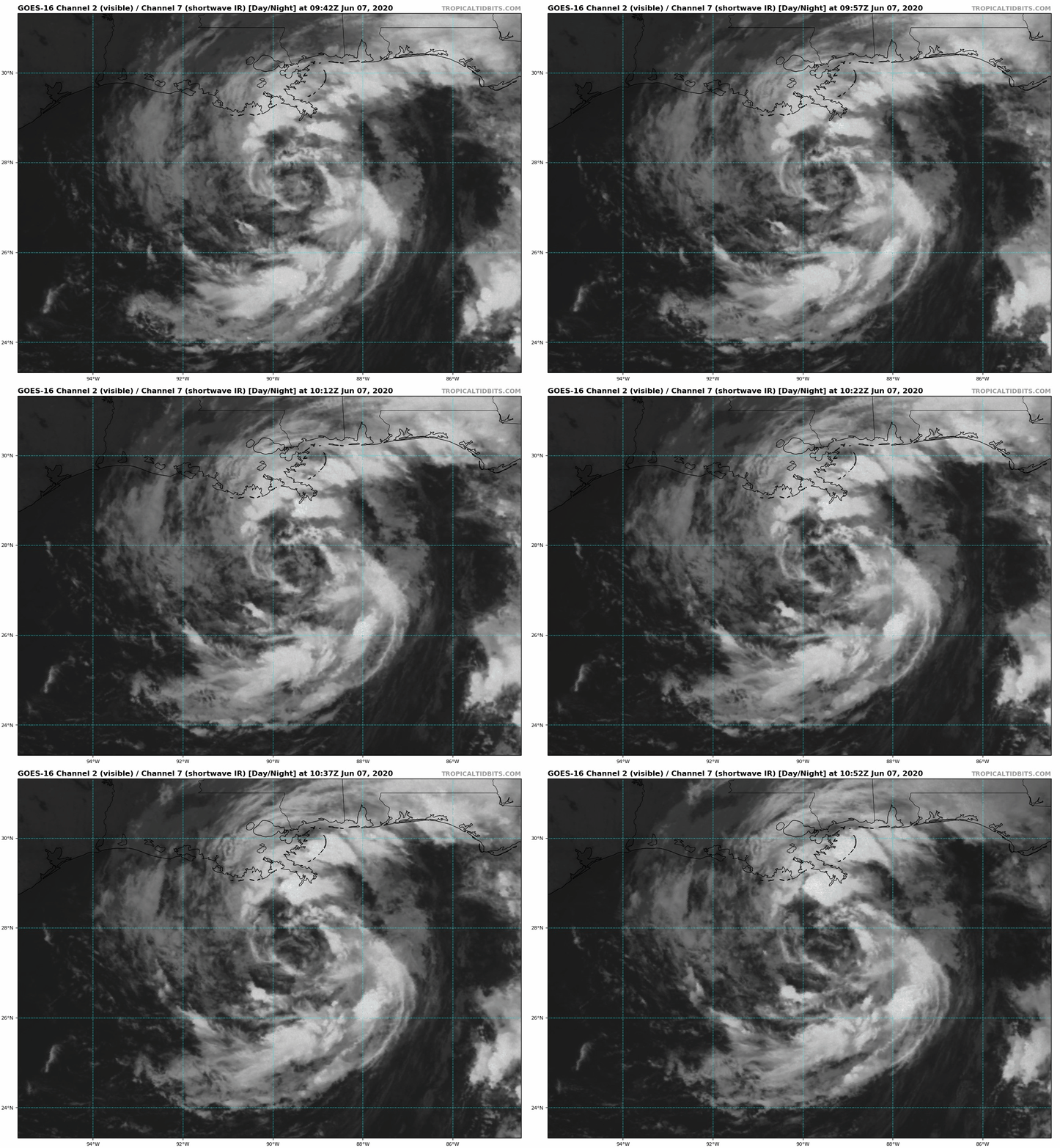
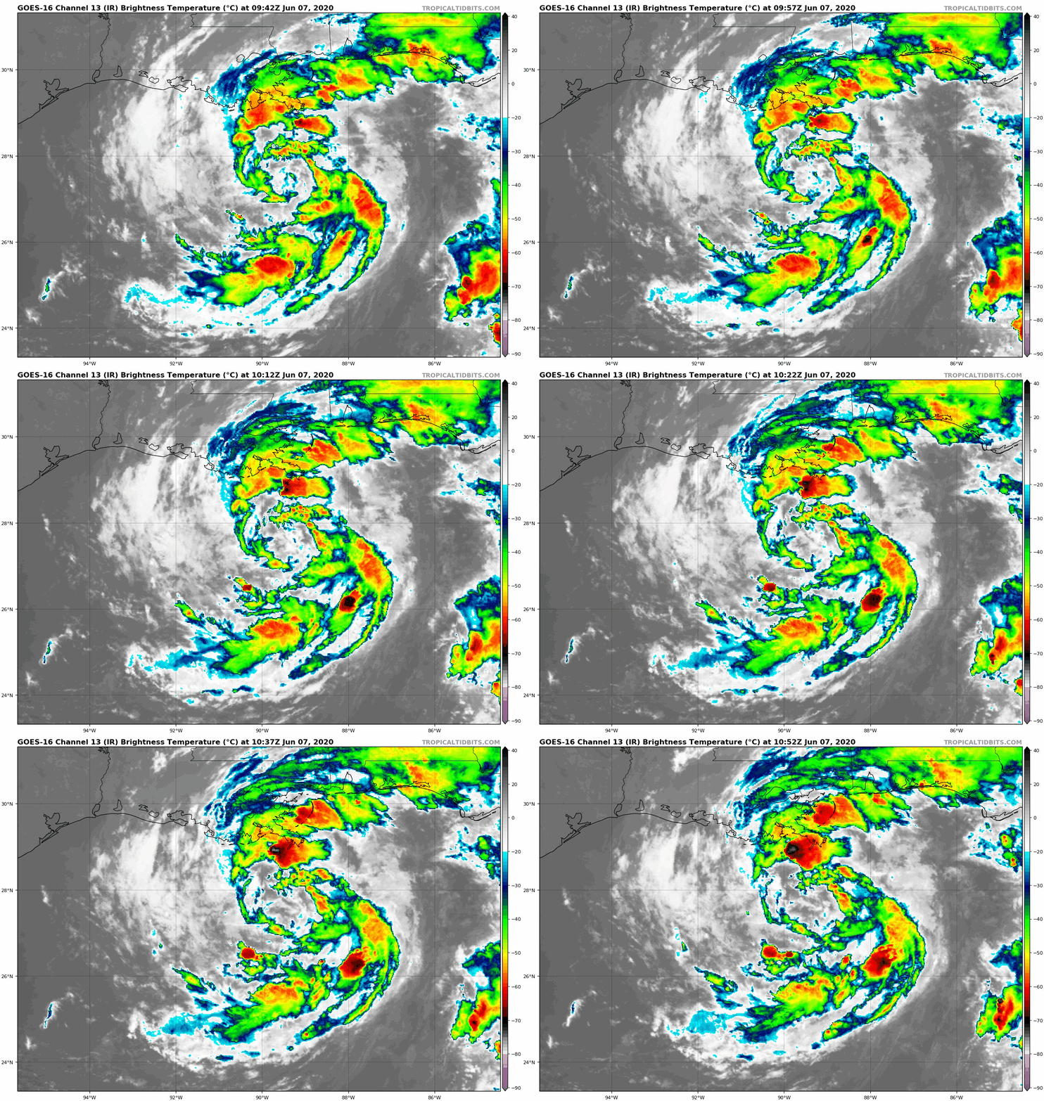
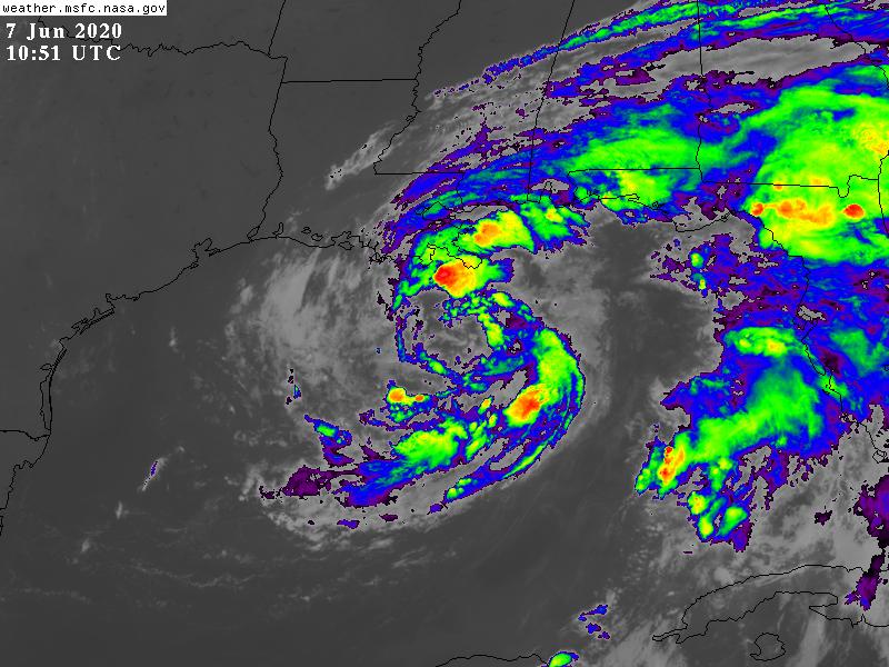
逐漸北上進逼美國,NHC預測Cristobal中心將於約+12H後接觸美國路易斯安那州陸地
WTNT43 KNHC 070845
TCDAT3

Tropical Storm Cristobal Discussion Number  23
NWS National Hurricane Center Miami FL       AL032020
400 AM CDT Sun Jun 07 2020

Cristobal continues to resemble a subtropical cyclone more than a
tropical cyclone.  The convection near the center remains limited,
although it has become a little better organized during the past
several hours.  In addition, aircraft and scatterometer data show
that the radius of maximum winds remains at or above 90 n mi.  
These data also suggest that a 45 kt intensity may be a bit
generous, but since the central pressure remains near 993 mb the
intensity has not changed for this advisory.

The initial motion is 360/10 between a deep-layer ridge to
Cristobal's east and a mid- to upper-level trough over the western
Gulf of Mexico.  This general motion should continue for 12-18 h,
followed by a turn toward the north-northwest due to a mid-latitude
ridge passing north of the cyclone.  After 36 h, a turn toward the
north and north-northeast is expected as Cristobal or its remnants
encounter the mid-latitude westerlies.  There are no important
changes to either the track guidance or the forecast track since the
last advisory.

The broad nature of the cyclone and significant dry air entrainment
is likely to prevent intensification before landfall, and the new
intensity forecast holds the intensity constant at 45 kt until
that time.  Weakening is expected after landfall, with Cristobal
weakening below tropical-storm strength just after the 24 h point.
The new intensity forecast shows slight re-intensification as the
system become extratropical at 72-96 h in agreement with the global
model guidance.

Cristobal remains a broad and asymmetric storm.  Therefore, one
should not focus on the exact forecast track, as the associated
winds, storm surge, and rainfall will extend well away the center.


Key Messages:

1. There is a danger of life-threatening storm surge outside of the
Hurricane and Storm Damage Risk Reduction System from the Mouth of
the Mississippi River to Ocean Springs, Mississippi, and a Storm
Surge Warning is in effect for those areas.  Life-threatening storm
surge remains possible in other portions of southern and
southeastern Louisiana where a Storm Surge Watch is in effect.
Residents in these locations should follow advice given by local
emergency officials.

2. Tropical storm force winds should spread along the northern Gulf
coast from central Louisiana to the western Florida Panhandle,
including metropolitan New Orleans today, and a Tropical Storm
Warning is in effect for this area.  These winds will arrive well
in advance of and extend well east of Cristobals center.

3. Heavy rainfall will continue across north Florida this morning,
spreading from east to west across the eastern and central Gulf
Coast from the Florida Panhandle into Louisiana today. The Central
Gulf Coast region will be most prone to issues after the passage of
the center of Cristobal from Sunday night into Monday. This heavy
rain will move up the Lower and Mid Mississippi Valley Monday into
Tuesday, then across the Upper Mississippi Valley and Northern
Plains Tuesday and Tuesday night. Flash flooding, and new and
renewed significant river flooding is possible, especially where
heavier rainfall occurs over portions of the Gulf Coast through the
Mississippi Valley.


FORECAST POSITIONS AND MAX WINDS

INIT  07/0900Z 27.3N  90.1W   45 KT  50 MPH
12H  07/1800Z 28.7N  90.3W   45 KT  50 MPH
24H  08/0600Z 30.8N  91.2W   35 KT  40 MPH...INLAND
36H  08/1800Z 33.3N  92.3W   30 KT  35 MPH...INLAND
48H  09/0600Z 36.6N  92.6W   25 KT  30 MPH...INLAND
60H  09/1800Z 40.9N  91.4W   25 KT  30 MPH...INLAND
72H  10/0600Z 46.0N  89.0W   30 KT  35 MPH...POST-TROP/EXTRATROP
96H  11/0600Z 52.0N  84.5W   30 KT  35 MPH...POST-TROP/EXTRATROP
120H  12/0600Z...MERGED WITH EXTRATROPICAL LOW

$$
Forecaster Beven
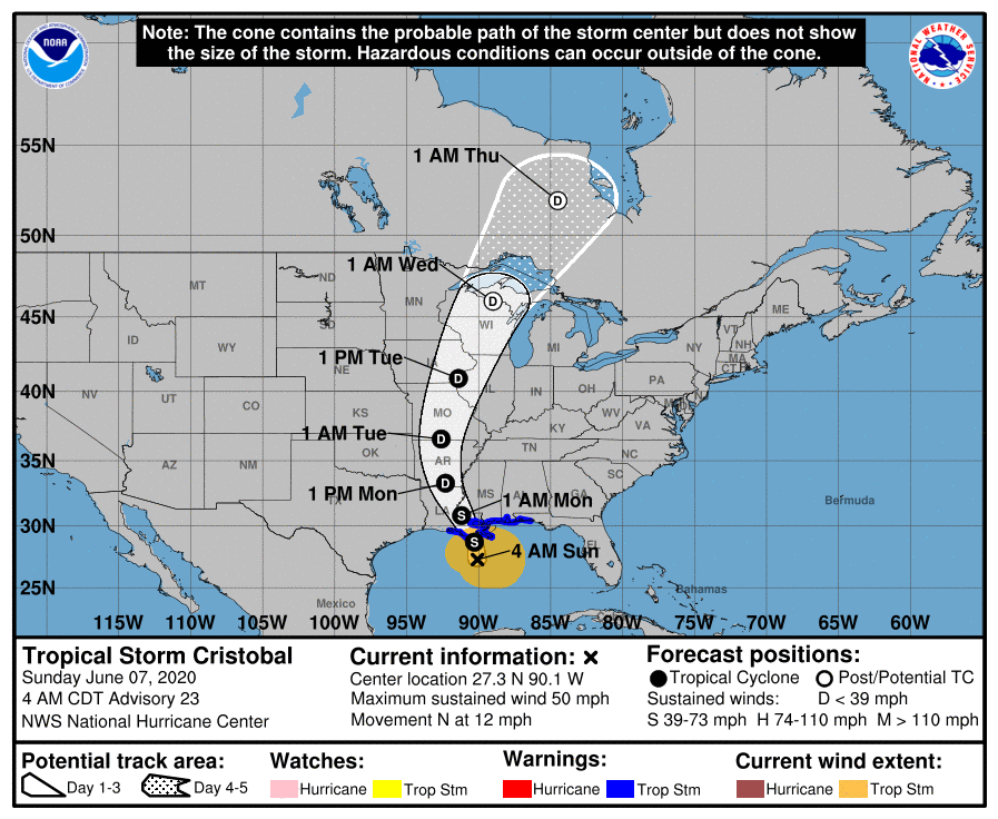
AL032020_5day_cone_no_line_and_wind.png
goes16_vis-swir_03L_202006070942.gif goes16_ir_03L_202006070942.gif
GOES10512020159nSI4zL.jpg
回復

使用道具 舉報

簽到天數: 1650 天

[LV.Master]伴壇終老

老農民版夜神月|2020-6-8 17:09 | 顯示全部樓層
已登陸並逐漸深入美國陸地,系統後期將轉化成為溫帶氣旋
000
WTNT43 KNHC 080836
TCDAT3

Tropical Depression Cristobal Discussion Number  27
NWS National Hurricane Center Miami FL       AL032020
400 AM CDT Mon Jun 08 2020

Radar and surface observations indicate that Cristobal has continued
to weaken as it moves farther inland.  The initial intensity is
reduced to 30 kt, with these winds occuring over portions of the
coastline and coastal waters from southeastern Louisiana to the
western Florida Panhandle.  The surface observations also indicate
that the central pressure is near 994 mb. While the cyclone is
weakening, satellite and radar data show a large area of convective
bands continuing in the northeastern quadrant.

The initial motion is now 330/9.  There is no change to the track
forecast philosophy from the previous advisory.  Cristobal should
continue north-northwestward today as a high pressure ridge over the
Great Lakes slides eastward.  The cyclone is expected to turn
northward by tonight around the east side of the ridge, and then it
should turn northeastward on Tuesday ahead of a mid-latitude trough
moving into the central United States. A faster northeastward
motion should bring the center of the cyclone across the Upper
Midwest on Tuesday and into Canada on Wednesday.  After that time,
the system is expected to slow down after it completes its
extratropical transition.  There is little change to the previous
forecast track except at 96 h, where the new forecast is a bit
south of the previous forecast.

The cyclone should continue to gradually weaken for the next
36-48 h as it moves farther inland.  After that time, some
re-intensification is expected as Cristobal becomes involved with
mid-latitude cyclogenesis over the Upper Mississippi Valley, and
the intensity forecast will call for the system to be a 35-kt
extratropical low by 60 h.  The cyclone is forecast to dissipate
inside the envelope of another extratropical low by 120 h. It should
be noted that Cristobal and the mid-latitude cyclone will combine to
possibly cause gusty winds over portions of the Midwest and Great
Lakes regions.

Although Cristobal has weakened, life-threatening storm surge is
expected to continue over a portion of the northern Gulf coast
today. Heavy rains associated with the system will also spread over
portions of the central United States over the next couple of days.


Key Messages:

1. Although the center of Cristobal has moved inland, there remains
a danger of life-threatening storm surge outside of the Hurricane
and Storm Damage Risk Reduction System from the Mouth of the
Mississippi River to Ocean Springs, Mississippi, and a Storm Surge
Warning is in effect for those areas.  Residents in these locations
should follow advice given by local emergency officials.

2. Heavy rain associated with Cristobal will continue to push inland
across the central Gulf coast and into the Lower Mississippi Valley
today, then up the Mid and Upper Mississippi Valley Monday night
through Tuesday night. The Central Gulf Coast region will be most
prone to heavy rain issues after the passage of the center of
Cristobal through Monday. Flash flooding, and new and renewed
significant river flooding is possible, especially where heavier
rainfall occurs over portions of the Gulf Coast through the
Mississippi Valley.

3. Wind gusts to tropical-storm force are expected this morning in
the coastal areas from southeastern Louisiana to the western
Florida Panhandle.  In addition, the combination of Cristobal and a
mid-latitude cyclone may cause gust winds by midweek over portions
of the Midwest and Great lakes regions.


FORECAST POSITIONS AND MAX WINDS

INIT  08/0900Z 31.0N  91.2W   30 KT  35 MPH...INLAND
12H  08/1800Z 32.7N  91.7W   30 KT  35 MPH...INLAND
24H  09/0600Z 35.8N  91.8W   25 KT  30 MPH...INLAND
36H  09/1800Z 39.9N  90.5W   25 KT  30 MPH...INLAND
48H  10/0600Z 44.7N  88.2W   30 KT  35 MPH...POST-TROP/REMNT LOW
60H  10/1800Z 49.0N  85.8W   35 KT  40 MPH...POST-TROP/EXTRATROP
72H  11/0600Z 51.0N  83.5W   35 KT  40 MPH...POST-TROP/EXTRATROP
96H  12/0600Z 51.5N  78.5W   35 KT  40 MPH...POST-TROP/EXTRATROP
120H  13/0600Z...DISSIPATED

$$
Forecaster Beven

083734_5day_cone_no_line_and_wind.png 03L_gefs_latest.png
GOES08512020160QoSjQG.jpg goes16_ir_03L_202006080747.gif
回復

使用道具 舉報

12
快速回覆
您需要登錄後才可以回帖 登錄 | 立即加入

本版積分規則

本平台僅供學術討論之用,預報應以氣象局為準

威普網站虛擬主機贊助公司

臺灣第一個天氣類型社群平台 即時天氣資訊、精準颱風動態

線上客服
FB傳送訊息
廣告行銷
精準行銷 物超所值
官方粉專
發佈 快速回復 返回頂部 返回列表