開啟輔助訪問
 找回密碼
 立即加入

15E.Julio 16L殘餘重新發展 緩慢西行

簽到天數: 1650 天

[LV.Master]伴壇終老

2020-9-4 20:52 來自手機 | 顯示全部樓層
  基本資料  
編號    :15 E
擾動編號日期:2020 09 04 20
撤編日期  :2020 09 09 00

90E.INVEST.25kts.1007mb.14.3N.94.7W
20200904.1053.f16.x.91h.90EINVEST.25kts-1007mb-143N-947W.082pc.jpg

FNMOC又壞了...
NHC:20%  
1. Showers and thunderstorms associated with the remnants of Atlantic
basin Tropical Depression Nana have increased over the Gulf of
Tehuantepec during the past several hours. Some slight development
is possible during the next day or two while the system moves
generally west-northwestward, near or along the southern coast of
Mexico. Unfavorable upper-level winds and proximity to land should
inhibit further development by late this weekend.
* Formation chance through 48 hours...low...30 percent.
* Formation chance through 5 days...low...30 percent.

two_pac_2d1.png two_pac_5d1.png

評分

參與人數 1水氣能量 +15 +1 收起 理由
s6815711 + 15 + 1 熱帶擾動首帖

查看全部評分

回復

使用道具 舉報

簽到天數: 1650 天

[LV.Master]伴壇終老

老農民版夜神月|2020-9-5 03:23 | 顯示全部樓層
本帖最後由 老農民版夜神月 於 2020-9-5 03:27 編輯

JTWC1830Z發布TCFA,NHC展望亦提升至60%
WTPN21 PHNC 041830
MSGID/GENADMIN/JOINT TYPHOON WRNCEN PEARL HARBOR HI//
SUBJ/TROPICAL CYCLONE FORMATION ALERT//
RMKS/
1. FORMATION OF A SIGNIFICANT TROPICAL CYCLONE IS POSSIBLE WITHIN
130 NM EITHER SIDE OF A LINE FROM 14.3N 94.3W TO 15.7N 101.0W
WITHIN THE NEXT 12 TO 24 HOURS. AVAILABLE DATA DOES NOT JUSTIFY
ISSUANCE OF NUMBERED TROPICAL CYCLONE WARNINGS AT THIS TIME.
WINDS IN THE AREA ARE ESTIMATED TO BE 20 TO 25 KNOTS. METSAT
IMAGERY AT 041200Z INDICATES THAT A CIRCULATION CENTER IS LOCATED
NEAR 14.3N 94.7W. THE SYSTEM IS MOVING WESTWARD AT 06 KNOTS.
2. REMARKS: THE AREA OF CONVECTON (INVEST 90E) PREVIOUSLY LOCATED
NEAR 14.4N 94.1W IS NOW LOCATED NEAR 14.3N 94.7W, APPROXIMATELY
117NM SOUTH-SOUTHEAST OF SALINA CRUZ, MEXICO. ANIMATED MULTISPECTRAL
SATELLITE IMAGERY AND A 041319Z SSMIS 91GHZ SHOWS A CONSOLIDATING
LOW LEVEL CIRCULATION (LLC) WITH FLARING CONVECTION ALONG THE EASTER
PERIPHERY OF THE DISTURBANCE. UPPER-LEVEL ANALYSIS REVEALS A
FAVORIABLE ENVIRONMENT FOR DEVELOPMENT WITH LOW VERTICAL WIND SHEAR
(< 15 KTS), GOOD EQUATORWARD OUTFLOW, AND WARM SST (29-30C). GLOBAL
DYNAMIC MODELS INDICATE SLIGHT INTENSIFICATION OVER THE NEXT 24-
36HRS AS THE SYSTEM TRACKS WEST-NORTHWESTWARD. MAXIMUM SUSTAINED
SURFACE WINDS ARE ESTIMATED AT 20 TO 25 KNOTS. MINIMUM SEA LEVEL
PRESSURE IS ESTIMATED TO BE NEAR 1004 MB. THE POTENTIAL FOR THE
DEVELOPMENT OF A SIGNIFICANT TROPICAL CYCLONE WITHIN THE NEXT 24
HOURS IS HIGH.
3. THIS ALERT WILL BE REISSUED, UPGRADED TO WARNING OR CANCELLED BY
051830Z.
//
NNNN
1. A well-defined surface low has formed near the Gulf of Tehuantepec.
Although most of the associated shower and thunderstorm activity is
displaced well to the west of the low, a few showers and
thunderstorms have recently developed near the center. Conditions
are expected to be only marginally conducive for further development
during the next couple of days, but only a small increase in
thunderstorm activity could result in the formation of a tropical
depression. This system is expected to move generally
west-northwestward, near or along the southern coast of Mexico
during the next few days.
* Formation chance through 48 hours...medium...60 percent.
* Formation chance through 5 days...medium...60 percent.

ep9020.gif two_pac_2d1.png
20200904.1830.goes-17.ir.90E.INVEST.25kts.1006mb.14.2N.95.5W.100pc.jpg goes16_ir_90E_202009041645.gif

評分

參與人數 1水氣能量 +15 收起 理由
king111807 + 15 TCFA

查看全部評分

回復

使用道具 舉報

簽到天數: 1650 天

[LV.Master]伴壇終老

老農民版夜神月|2020-9-6 02:21 | 顯示全部樓層
本帖最後由 老農民版夜神月 於 2020-9-6 08:32 編輯

NHC展望提升至70%,NHC18Z定強35KT
1. A small well-defined low pressure system is located about 150 miles
southwest of Acapulco, Mexico. The low is producing
tropical-storm-force winds over a small area to the north of its
center, but the associated thunderstorm activity remains
intermittent. Conditions do not appear to be favorable for much
further development, but only a small increase in the organization
of thunderstorms near the center of the circulation would result in
the formation of a tropical storm. This system is expected to move
generally west-northwestward, near or along the southwestern coast
of Mexico during the next couple of days. Regardless of development,
this low could produce locally heavy rainfall along portions of the
southwestern coast of Mexico. For more information, please consult
products from your local meteorological office.
* Formation chance through 48 hours...high...70 percent.
* Formation chance through 5 days...high...70 percent.

two_pac_2d1.png two_pac_5d1.png 20200905.1800.goes-17.ir.90E.INVEST.35kts.1005mb.15.8N.101.9W.100pc.jpg


回復

使用道具 舉報

簽到天數: 1650 天

[LV.Master]伴壇終老

老農民版夜神月|2020-9-6 08:30 | 顯示全部樓層
NHC21Z直接升格TS15E,命名Julio,上望40KT
846
WTPZ45 KNHC 052034
TCDEP5

Tropical Storm Julio Discussion Number   1
NWS National Hurricane Center Miami FL       EP152020
400 PM CDT Sat Sep 05 2020

The mid-level remnants of Atlantic Hurricane Nana have moved
westward and west-northwestward off the southwestern coast of Mexico
while producing intermittent convection during the last few days. A
well-defined low formed about a day ago and ASCAT data indicates
that it has been producing tropical-storm-force winds for the past
12 h or so. During the past few hours there has also been an
increase in deep convection near the center of the low, and the most
recent Dvorak classification from TAFB was T-2.5, indicating that
the system is sufficiently well-organized to be considered a
tropical cyclone. Since the low-level center of Nana dissipated
inland over Central Atlantic, the new tropical storm is named Julio,
the tenth of the northern East Pacific season. The TAFB Dvorak
classification and 15Z ASCAT data are the basis for the 35 kt
initial intensity. Since the ASCAT explicitly showed 35 kt winds and
that instrument typically under-samples the maximum winds, it is
possible this intensity is a little conservative.

Most of the dynamical models do not acknowledge the existence of
tiny Julio in their initial conditions. Only the ECMWF and its
ensemble show a small well-defined low and it therefore is the
primary basis for the NHC track forecast. In general, Julio should
continue west-northwestward at a slower forward speed for the next
couple of days, steered by a mid-level ridge to the northeast. Julio
is forecast to become a shallow remnant low in a few days and should
slow down to a crawl before it dissipates early next week. Since the
forecast is based largely on one modeling system rather than the
typical NHC consensus approach, confidence in the track forecast is
fairly low.

The tropical storm will be affected by strong easterly wind shear
for the next day or two and little or no further strengthening is
likely during that time. Although the shear could decrease by early
next week, Julio will reach a drier and more stable environment in a
couple of days. It is therefore forecast to become a remnant low
within 60 h and dissipate shortly thereafter. The NHC forecast is
based on a blend of the ECMWF and the statistical DSHP and LGEM
models since the HWRF and the GFS-dependent HMON models do not
appear to have a good handle on the initial state of the system.


FORECAST POSITIONS AND MAX WINDS

INIT  05/2100Z 16.1N 102.7W   35 KT  40 MPH
12H  06/0600Z 16.9N 105.0W   40 KT  45 MPH
24H  06/1800Z 18.0N 107.5W   40 KT  45 MPH
36H  07/0600Z 19.0N 109.4W   35 KT  40 MPH
48H  07/1800Z 19.9N 110.6W   30 KT  35 MPH
60H  08/0600Z 20.5N 111.0W   25 KT  30 MPH...POST-TROP/REMNT LOW
72H  08/1800Z...DISSIPATED

$$
Forecaster Zelinsky
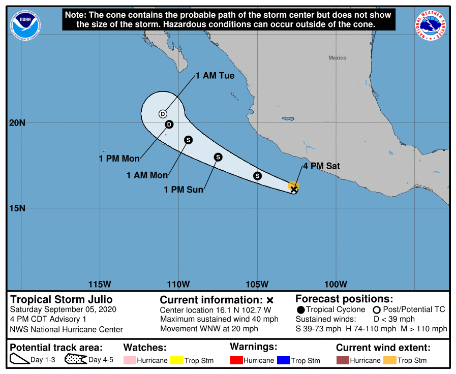
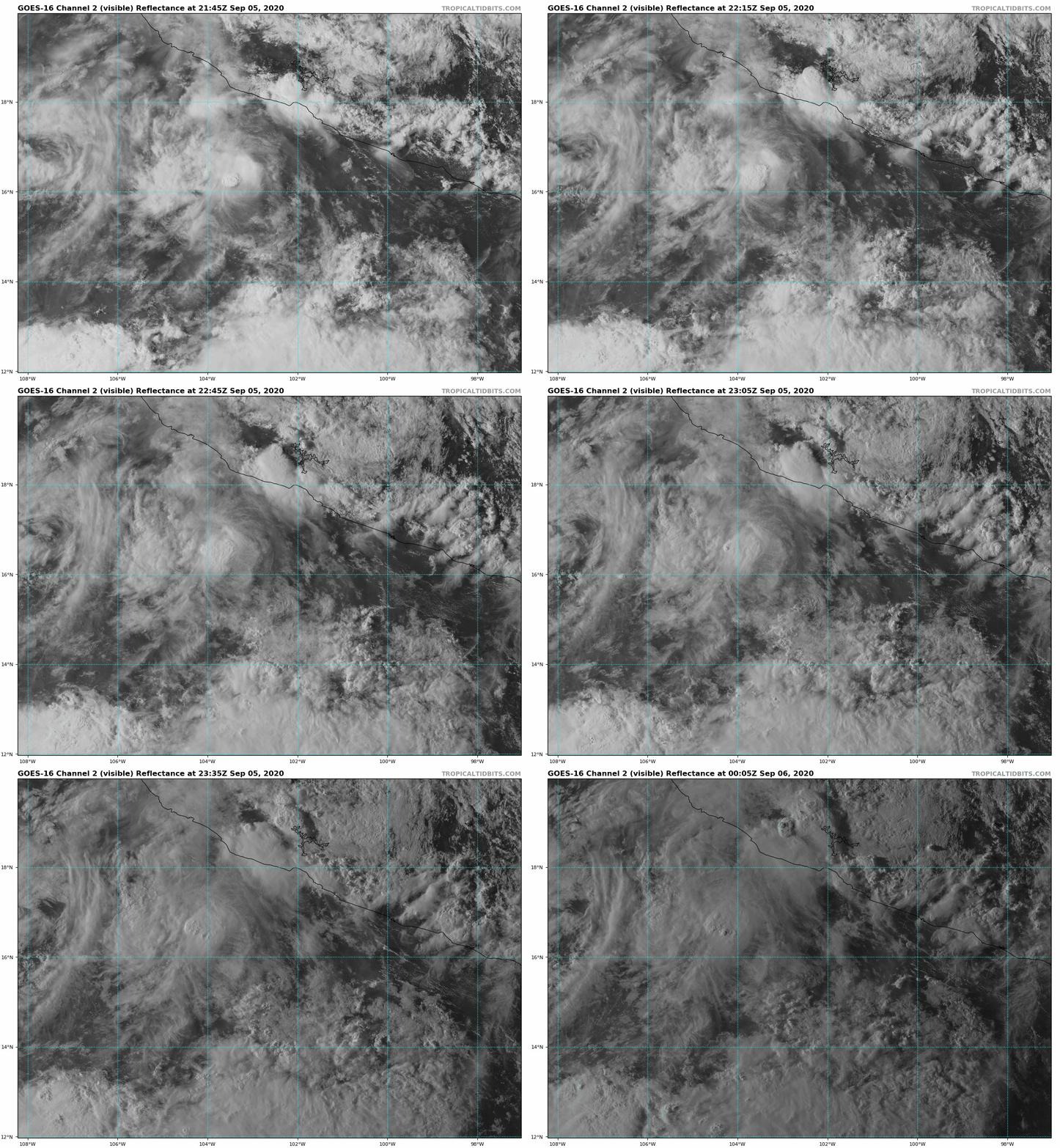
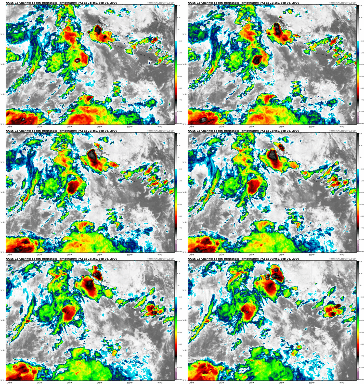
203527_5day_cone_no_line_and_wind.png goes16_vis_15E_202009052145.gif
goes16_ir_15E_202009052145.gif
回復

使用道具 舉報

簽到天數: 1650 天

[LV.Master]伴壇終老

老農民版夜神月|2020-9-7 16:44 | 顯示全部樓層
NHC09Z判定Julio已減弱為殘餘低氣壓,並發出最終報
000
WTPZ45 KNHC 070839
TCDEP5

Remnants Of Julio Discussion Number   7
NWS National Hurricane Center Miami FL       EP152020
300 AM MDT Mon Sep 07 2020

Moderate easterly shear has continued to take a toll on the compact
tropical cyclone.  In fact, recent satellite imagery and ASCAT data
indicate that the small circulation has opened up into a trough of
low pressure.  Therefore, Julio has dissipated and this will be the
final NHC advisory on this system.  Julios demise occurred much
quicker than forecast, owing to the difficulty in predicting the
intensity (both up and down) of small tropical cyclones.  The
remnants are moving westward around the northern portion of a broad
area of low pressure to the southwest of Socorro Island, and the
remnants should be absorbed within that system later today.  The
global models indicate that moderate to strong easterly shear will
persist over the larger low pressure area in which Julio is being
absorbed, and this will likely prevent significant development of
that system over the next few days.

This is last NHC advisory on this system. For additional information
on the remnants of Julio please see High Seas Forecasts issued
by the National Weather Service, under AWIPS header NFDHSFEPI, WMO
header FZPN02 KWBC, and on the web at
ocean.weather.gov/shtml/NFDHSFEPI.php


FORECAST POSITIONS AND MAX WINDS

INIT  07/0900Z 19.5N 112.6W   25 KT  30 MPH
12H  07/1800Z...DISSIPATED

$$
Forecaster Brown

084039_5day_cone_no_line_and_wind.png 未命名.png
GOES0800202025159HMkS.jpg
回復

使用道具 舉報

簽到天數: 1650 天

[LV.Master]伴壇終老

老農民版夜神月|2020-9-8 01:52 | 顯示全部樓層
NHC展望10%/20%
1. A broad area of low pressure consisting of multiple low-level swirls
is located several hundred miles southwest of the southern tip of
the Baja California peninsula. This system is producing only limited
and disorganized showers and thunderstorms. Little or no development
of the disturbance is expected for the next day or so due to strong
upper-level winds. Environmental conditions are expected to become
less hostile by Wednesday and some slight development is possible
thereafter.
* Formation chance through 48 hours...low...10 percent.
* Formation chance through 5 days...low...20 percent.

two_pac_2d1.png two_pac_5d1.png
15E_gefs_latest.png
回復

使用道具 舉報

快速回覆
您需要登錄後才可以回帖 登錄 | 立即加入

本版積分規則

本平台僅供學術討論之用,預報應以氣象局為準

威普網站虛擬主機贊助公司

臺灣第一個天氣類型社群平台 即時天氣資訊、精準颱風動態

線上客服
FB傳送訊息
廣告行銷
精準行銷 物超所值
官方粉專
發佈 快速回復 返回頂部 返回列表