開啟輔助訪問
 找回密碼
 立即加入

23P.Niran 巔峰達澳式C5 南半球新風季第三個C5

簽到天數: 1650 天

[LV.Master]伴壇終老

老農民版夜神月|2021-3-2 02:37 | 顯示全部樓層
本帖最後由 老農民版夜神月 於 2021-3-2 03:18 編輯

JTWC18Z定強已提升至45節,BoM稍會可能即將命名
23P TWENTYTHRE 210301 1800 15.3S 147.4E SHEM 45 984
20210301.1850.himawari-8.ir.23P.TWENTYTHRE.45kts.984mb.15.3S.147.4E.100pc.jpg 20210301.1833.f18.91pct91h91v.23P.TWENTYTHRE.45kts.984mb.15.3S.147.4E.070pc.jpg 20210301.1833.f18.91h.23P.TWENTYTHRE.45kts.984mb.15.3S.147.4E.070pc.jpg
回復

使用道具 舉報

簽到天數: 1650 天

[LV.Master]伴壇終老

老農民版夜神月|2021-3-2 04:28 | 顯示全部樓層
BoM命名Niran,定強40KT
IDQ20018
TROPICAL CYCLONE TECHNICAL BULLETIN: AUSTRALIA - EASTERN REGION
Issued by AUSTRALIAN BUREAU OF METEOROLOGY TROPICAL CYCLONE WARNING CENTRE
at: 1953 UTC 01/03/2021
Name: Tropical Cyclone Niran
Identifier: 17U
Data At: 1800 UTC
Latitude: 15.5S
Longitude: 147.4E
Location Accuracy: within 30 nm [55 km]
Movement Towards: northeast [040 deg]
Speed of Movement: 8 knots [15 km/h]
Maximum 10-Minute Wind: 40 knots [75 km/h]
Maximum 3-Second Wind Gust: 65 knots [120 km/h]
Central Pressure: 984 hPa
Radius of 34-knot winds NE quadrant: 60 nm [110 km]
Radius of 34-knot winds SE quadrant: 60 nm [110 km]
Radius of 34-knot winds SW quadrant: 75 nm [140 km]
Radius of 34-knot winds NW quadrant: 60 nm [110 km]
Radius of 48-knot winds NE quadrant:   
Radius of 48-knot winds SE quadrant:   
Radius of 48-knot winds SW quadrant:   
Radius of 48-knot winds NW quadrant:   
Radius of 64-knot winds:
Radius of Maximum Winds: 20 nm [35 km]
Dvorak Intensity Code: T3.0/3.0/D0.5/24HRS STT: D0.5/06HRS
Pressure of outermost isobar: 1002 hPa
Radius of outermost closed isobar: 220 nm [405 km]
FORECAST DATA
Date/Time    : Location    : Loc. Accuracy: Max Wind   : Central Pressure
[UTC]        : degrees     :      nm  [km]: knots[km/h]: hPa
+06:  02/0000: 15.3S 147.6E:     040 [075]:  045  [085]:  988
+12:  02/0600: 15.3S 147.8E:     055 [100]:  050  [095]:  987
+18:  02/1200: 15.3S 148.0E:     065 [120]:  050  [095]:  982
+24:  02/1800: 15.3S 147.9E:     070 [130]:  060  [110]:  979
+36:  03/0600: 15.5S 147.6E:     075 [140]:  060  [110]:  978
+48:  03/1800: 15.5S 147.7E:     095 [175]:  065  [120]:  974
+60:  04/0600: 15.7S 148.7E:     110 [205]:  070  [130]:  972
+72:  04/1800: 16.5S 150.8E:     140 [255]:  080  [150]:  967
+96:  05/1800: 19.7S 156.9E:     230 [425]:  080  [150]:  960
+120: 06/1800: 24.5S 166.4E:     310 [580]:  060  [110]:  974
REMARKS:
The centre fix of tropical low 17U is based on surface observations, animated
satellite imagery and recent microwave satellite passes. Centre location is fair
to good. The LLCC has persisted close to the edge of the deep convection over
the past 6 hours, and recently more vigorous convection has developed near the
centre. Observations from offshore reefs have been impressive, with the system
tracking directly over Bougainville Reef where strong gales were observed in
both the northeast and southwest quadrants and the surface pressure dropped to
984.0 hPa. Intensity estimates from Dvorak analyses have been considerably lower
than surface observations. DT is based on a shear pattern yielding 3.0, this was
set as the FT.

The system lies in close proximity to the upper ridge, in an environment of weak
vertical shear. The upper outflow remains good on the poleward side and has
somewhat improved elsewhere. Expect the system to develop at a near standard
rate.

The steering pattern will remain weak in the short term. Late Tuesday into
Wednesday, some redevelopment of the mid level ridge to the south of the system
is forecast, with a brief shift to a westwards track possible in response -- the
details of how far west the cyclone is steered are critical for the potential
return of severe weather along the Queensland coast, and this remains uncertain
at present.. A coastal crossing of the centre of the cyclone remains unlikely
however. From Thursday, a stronger upper trough is very likely to capture the
system and steer it to the southeast across the southeastern Coral Sea and out
of the Australian area of responsibility.

Copyright Commonwealth of Australia
==
The next bulletin for this system will be issued by: 02/0130 UTC.
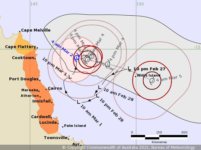
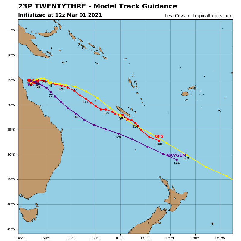
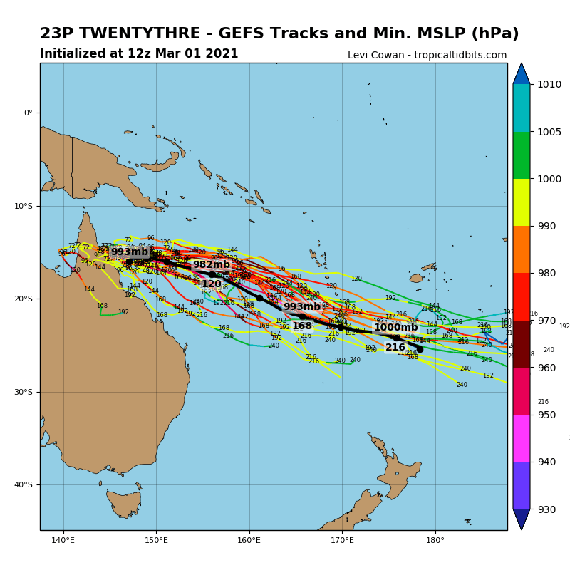
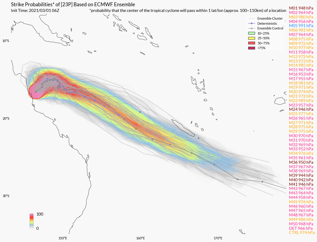
IDQ65001.png 23P_tracks_latest.png
23P_gefs_latest.png 23P.png
回復

使用道具 舉報

簽到天數: 483 天

[LV.9]以壇為家II

dom|2021-3-2 12:15 | 顯示全部樓層
BoM升格澳式C2
Details of Tropical Cyclone Niran at 1:00 pm AEST:

Intensity: category 2, sustained winds near the centre of 95 kilometres per hour with wind gusts to 130 kilometres per hour.
Location: within 35 kilometres of 15.0 degrees South, 147.5 degrees East , 280 kilometres northeast of Cairns and 255 kilometres east northeast of Cooktown .
Movement: north northwest at 7 kilometres per hour .

Tropical cyclone Niran is expected to remain slow-moving off the north Queensland coast while intensifying further over the next day or two to a Category 3 system.

Coastal crossing of the cyclone is not expected. However, as the cyclone develops, it may extend gales about the coastal and island communities tonight or on Wednesday.

From Thursday onwards, the cyclone is expected to take a southeasterly track, away from the coast.
IDA00041.png IDQ65001.png 螢幕快照 2021-03-02 下午12.14.52.png
回復

使用道具 舉報

簽到天數: 1650 天

[LV.Master]伴壇終老

老農民版夜神月|2021-3-2 12:37 | 顯示全部樓層
本帖最後由 老農民版夜神月 於 2021-3-2 12:39 編輯

從02Z的最新底層圖看Niran是順眼多了,底層眼似乎也有要建立的跡象
20210302.0250.gpm.89pct89h89v.23P.NIRAN.45kts.993mb.15.1S.147.7E.055pc.jpg 20210302.0250.gpm.89hbt.23P.NIRAN.45kts.993mb.15.1S.147.7E.055pc.jpg 20210302.0400.himawari-8.vis.23P.NIRAN.45kts.993mb.15.1S.147.7E.100pc.jpg LATEST - 2021-03-02T123307.122.jpg
回復

使用道具 舉報

簽到天數: 483 天

[LV.9]以壇為家II

dom|2021-3-2 15:07 | 顯示全部樓層
BoM預測+24H增強為澳式C3,JTWC06Z定強50KT,持續上望C1
23P NIRAN 210302 0600 14.8S 148.0E SHEM 50 990
Details of Tropical Cyclone Niran at 4:00 pm AEST:

Intensity: category 2, sustained winds near the centre of 95 kilometres per hour with wind gusts to 130 kilometres per hour.
Location: within 35 kilometres of 14.7 degrees South, 147.7 degrees East , 320 kilometres northeast of Cairns and 275 kilometres east northeast of Cooktown .
Movement: north northeast at 8 kilometres per hour .

Tropical cyclone Niran is expected to remain slow-moving off the north Queensland coast while gradually intensifying over the next two days.

Coastal crossing of the cyclone is not expected. However, as the cyclone develops or if it drifts slightly westwards, then it may cause gales about the exposed coastal and island communities on Wednesday.

From Thursday onwards, the cyclone is expected to take a southeasterly track, away from the coast.
IDA00041.png IDQ65001.png 螢幕快照 2021-03-02 下午3.05.22.png 6e7cc65c103853434587816a8413b07ecb808883.jpg.gif ab493a292df5e0fe6bb8894a4b6034a85fdf72ab.jpg

回復

使用道具 舉報

簽到天數: 1650 天

[LV.Master]伴壇終老

老農民版夜神月|2021-3-2 16:07 | 顯示全部樓層
增強速度有些超乎原本預期,JTWC09Z報上調預測巔峰強度至80節
sh2321.gif 23P_020600sair.jpg 20210302.0740.himawari-8.ir.23P.NIRAN.50kts.990mb.14.8S.148E.100pc.jpg
回復

使用道具 舉報

簽到天數: 1650 天

[LV.Master]伴壇終老

老農民版夜神月|2021-3-3 07:16 | 顯示全部樓層
SSMIS20Z最新底層
20210302.2046.f17.91pct91h91v.23P.NIRAN.55kts.984mb.14.9S.148.6E.080pc.jpg 20210302.2046.f17.91hw.23P.NIRAN.55kts.984mb.14.9S.148.6E.080pc.jpg
20210302.2046.f17.91h.23P.NIRAN.55kts.984mb.14.9S.148.6E.080pc.jpg 20210302.2250.himawari-8.vis.23P.NIRAN.55kts.983mb.14.7S.148.2E.100pc.jpg
回復

使用道具 舉報

簽到天數: 1650 天

[LV.Master]伴壇終老

老農民版夜神月|2021-3-3 08:40 | 顯示全部樓層
本帖最後由 老農民版夜神月 於 2021-3-3 08:46 編輯

JTWC00Z升格C1,定強65節
23P NIRAN 210303 0000 14.7S 148.3E SHEM 65 974

20210303.0020.goes-17.ir.23P.NIRAN.65kts.974mb.14.7S.148.3E.100pc.jpg ir_lalo-animated (13).gif avn_lalo-animated (3).gif
回復

使用道具 舉報

快速回覆
您需要登錄後才可以回帖 登錄 | 立即加入

本版積分規則

本平台僅供學術討論之用,預報應以氣象局為準

威普網站虛擬主機贊助公司

臺灣第一個天氣類型社群平台 即時天氣資訊、精準颱風動態

線上客服
FB傳送訊息
廣告行銷
精準行銷 物超所值
官方粉專
發佈 快速回復 返回頂部 返回列表