開啟輔助訪問
 找回密碼
 立即加入

26S.Seroja 曾增強至澳式C3 登陸澳洲

簽到天數: 1650 天

[LV.Master]伴壇終老

2021-3-31 22:06 | 顯示全部樓層
  三級強烈熱帶氣旋  
編號:26 S ( 22 U )
名稱:Seroja
040802vvk5lvm5t0sssjvp.jpg
  基本資料  
擾動編號日期:2021 03 31 21
JTWC升格日期:2021 04 04 20
命名日期  :2021 04 05 04
撤編日期  :2021 04 12 14
登陸地點  :澳洲


  巔峰時期資料  
近中心最強風速
澳洲氣象局 (BoM):65 kt
聯合颱風警報中心(JTWC):70 kt ( Cat.1 )
海平面最低氣壓   :971 百帕

  擾動編號資料  

99P.INVEST.15kts.998mb.9.3S.123E
20210331.1340.himawari-8.ir.99P.INVEST.15kts.998mb.9.3S.123E.100pc.jpg
以上資料來自:BoM、JTWC、颱風論壇整理製作

評分

參與人數 1水氣能量 +15 +1 收起 理由
king111807 + 15 + 1 熱帶擾動首帖

查看全部評分

回復

使用道具 舉報

簽到天數: 1650 天

[LV.Master]伴壇終老

老農民版夜神月|2021-3-31 22:29 | 顯示全部樓層
本帖最後由 老農民版夜神月 於 2021-3-31 23:21 編輯

BoM編號22U
Tropical activity has increased along a trough near Indonesia, and a tropical low (22U) is likely to consolidate on Thursday. The system may move south into the Western Region on Thursday and Friday and be located well to the north of the Kimberley coast. It is a Low chance of developing into a tropical cyclone by this stage.

There is a large amount of uncertainty as to where 22U will move after Friday, with it possibly remaining slow moving north of the Kimberley coast, start to move towards the southwest remaining well off the WA coast or move towards the southeast through the Timor Sea. Regardless of where is is located there is the potential for the system to develop further over the weekend but is not expected to impact the WA mainland during this period.


Likelihood of this system being a tropical cyclone in the Western Region on:
Thursday: Low
Friday: Low
Saturday:Moderate

sfcplot_99S_latest (1).png aus (8).png LATEST - 2021-03-31T232009.065.jpg LATEST - 2021-03-31T231959.322.jpg
回復

使用道具 舉報

簽到天數: 483 天

[LV.9]以壇為家II

dom|2021-3-31 22:52 | 顯示全部樓層
數值反應強烈,ECMWF00Z巔峰928百帕
223A102C-8BD7-477A-A900-53839054B02F.gif 1AB51228-F1A2-477C-AFAB-A4CFF65D66C1.gif ECE98883-DF0B-4355-90E3-B0D9E444BF7A.png F01A956F-61B7-4D4E-88DD-FC1CB55CDF3F.png
回復

使用道具 舉報

簽到天數: 1650 天

[LV.Master]伴壇終老

老農民版夜神月|2021-4-1 00:31 | 顯示全部樓層
本帖最後由 老農民版夜神月 於 2021-4-1 02:22 編輯

這個系統其實已經存在至少兩天左右了,現在才編擾著實有點晚。。
這也讓JTWC一開始就對其定強20節
99S INVEST 210331 1200 9.3S 123.0E SHEM 20 1007

20210331.1600.himawari-8.ir.99S.INVEST.20kts.1007mb.9.3S.123E.100pc.jpg 20210331.1600.himawari-8.irbd.99S.INVEST.20kts.1007mb.9.3S.123E.100pc.jpg
20210331.1600.himawari-8.ircolor.99S.INVEST.20kts.1007mb.9.3S.123E.100pc.jpg 99S_tracks_latest (1).png
99S_gefs_latest (4).png
回復

使用道具 舉報

簽到天數: 1650 天

[LV.Master]伴壇終老

老農民版夜神月|2021-4-1 21:10 | 顯示全部樓層
本帖最後由 老農民版夜神月 於 2021-4-1 21:13 編輯

JTWC於12Z升格TD
99S INVEST 210401 1200 9.3S 121.9E SHEM 25 1004
20210401.1250.himawari-8.ir.99S.INVEST.25kts.1004mb.9.3S.121.9E.100pc.jpg 99S_tracks_latest (2).png 99S_gefs_latest (5).png aus (9).png
回復

使用道具 舉報

簽到天數: 483 天

[LV.9]以壇為家II

dom|2021-4-2 09:33 | 顯示全部樓層
JTWC00Z暫將其降格為擾動
99S INVEST 210402 0000 9.9S 121.8E SHEM 20 1007
4D6CE319-9BBE-4F6A-B34F-60BE72F0B973.jpeg
回復

使用道具 舉報

簽到天數: 483 天

[LV.9]以壇為家II

dom|2021-4-2 14:07 | 顯示全部樓層
BoM將評級提升至High
A tropical low (22U) is expected to form just to the south of the island of Timor later today (Friday). The system should then move south into the Western Region over the weekend and be located well to the north of the Kimberley coast. It is expected to develop into a tropical cyclone during Sunday or Monday.
From Monday 22U is likely to move in a southwesterly direction, roughly parallel to the WA coast. The environment in this area is favourable, and it should continue to develop. It will most likely remain far enough offshore to not directly impact the WA mainland until at least the middle of next week, but people in the north of WA are urged to keep up-to-date with the latest forecasts and warnings.

Likelihood of this system being a tropical cyclone in the Western Region on:
Saturday:Moderate
Sunday:Moderate
Monday:High
D5B13C48-DA85-4985-A0D6-72831CD528C8.jpeg
回復

使用道具 舉報

簽到天數: 483 天

[LV.9]以壇為家II

dom|2021-4-2 16:44 | 顯示全部樓層
本帖最後由 dom 於 2021-4-2 16:46 編輯

JTWC0830Z直接評級Medium
     (2) AN AREA OF CONVECTION (INVEST 99S) HAS PERSISTED NEAR
10.4S 122.2E, APPROXIMATELY 14 NM EAST-NORTHEAST OF SAWU ISLAND,
INDONESIA. RECENT VISIBLE SATELLITE IMAGERY SHOWS AN ELONGATED LOW-
LEVEL CIRCULATION BECOMING BETTER ORGANIZED BETWEEN A BELT OF 20-25
KT EASTERLIES IN THE TIMOR SEA AND A BELT OF 30-35 KT WESTERLIES
NORTH OF THE SAVU SEA, AS ASSESSED FROM A 020146Z ASCAT-C PASS. DEEP
CONVECTION IS PATCHY AND DECENTRALIZED, BUT FORMATIVE CURVED BANDING
IS BECOMING APPARENT IN THE SOUTHERN, WESTERN, AND NORTHERN
SEMICIRCLES. 99S IS EMBEDDED IN A FAVORABLE ENVIRONMENT WITH LIGHT
NORTHERLY VERTICAL SHEAR OF 10 KTS, WARM SEA SURFACE TEMPERATURES OF
30C, AND DEEP-LAYER MOISTURE. DYNAMICAL MODELS SUPPORT CONTINUED
CONSOLIDATION OF THE BROAD CIRCULATION INTO A TROPICAL CYCLONE SOUTH
OF TIMOR-LESTE IN 24-48 HOURS. MAXIMUM SUSTAINED SURFACE WINDS
DIRECTLY ASSOCIATED WITH THE CIRCULATION ARE ESTIMATED AT 25 KNOTS.
MINIMUM SEA LEVEL PRESSURE IS ESTIMATED TO BE NEAR 1003 MB. THE
POTENTIAL FOR THE DEVELOPMENT OF A SIGNIFICANT TROPICAL CYCLONE
WITHIN THE NEXT 24 HOURS IS MEDIUM.
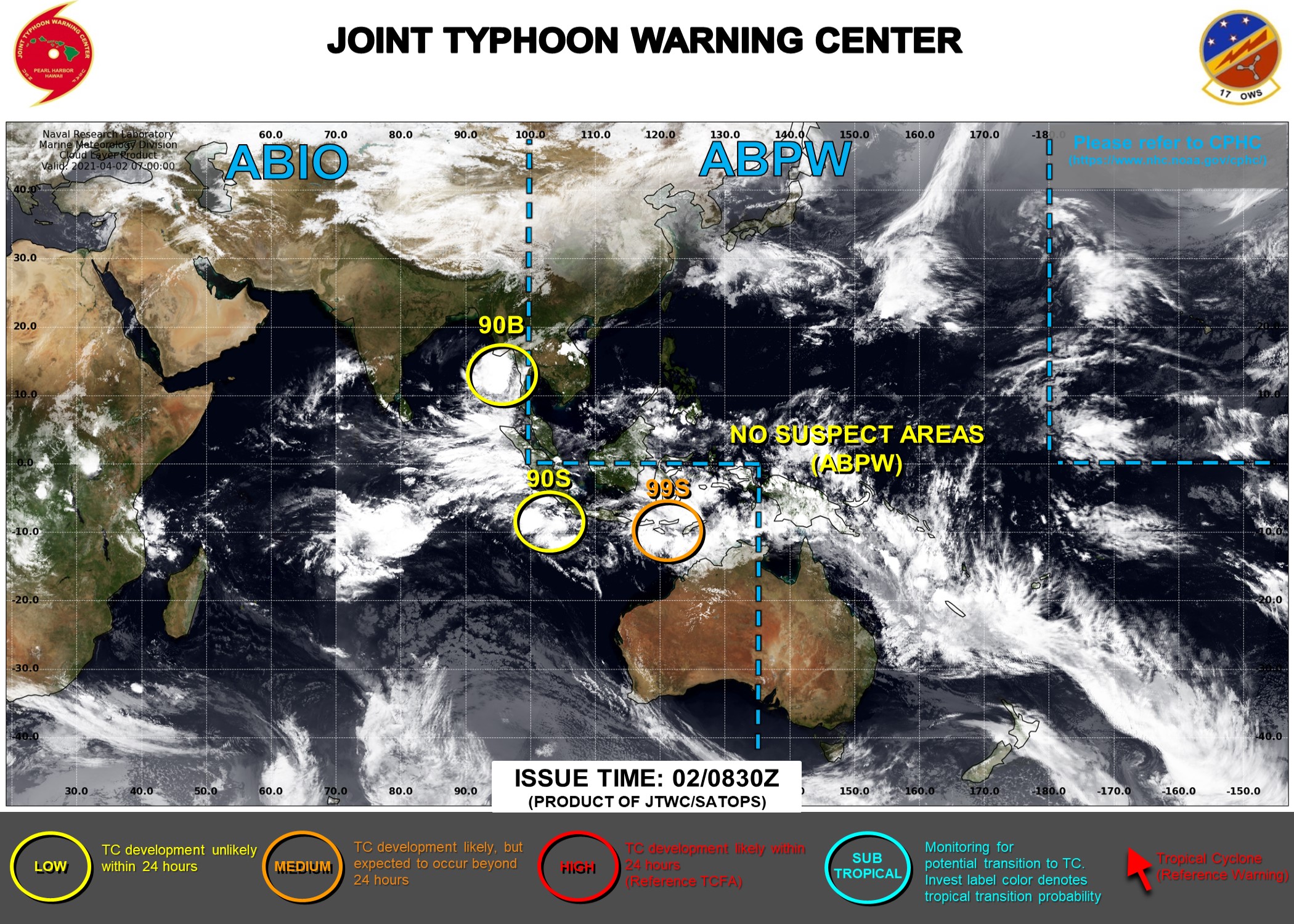
09695A16-2A64-4CA5-8863-813B14CC6D95.jpeg
回復

使用道具 舉報

快速回覆
您需要登錄後才可以回帖 登錄 | 立即加入

本版積分規則

本平台僅供學術討論之用,預報應以氣象局為準

威普網站虛擬主機贊助公司

臺灣第一個天氣類型社群平台 即時天氣資訊、精準颱風動態

線上客服
FB傳送訊息
廣告行銷
精準行銷 物超所值
官方粉專
發佈 快速回復 返回頂部 返回列表