開啟輔助訪問
 找回密碼
 立即加入

18E.Sonia 逐漸減弱

簽到天數: 3311 天

[LV.Master]伴壇終老

2025-10-23 22:00 | 顯示全部樓層
  熱帶風暴  
編號:18 E
名稱:Sonia
20252972130_GOES18-ABI-FL-GEOCOLOR-EP182025-1000x1000.jpg
  基本資料  
擾動編號日期:2025 10 23 14
命名日期  :2025 10 25 17
登陸地點  :

  巔峰時期資料  
近中心最強風速 :45 kt
( TS )
海平面最低氣壓 :1001 毫巴

  過去路徑圖  
- 來源:維基百科

Sonia_2025_path.png
  擾動編號資料  

92E.INVEST.15kts-1009mb-10.3N-108.0W
20251023_133022_EP922025_abi_goes-18_Infrared_15kts_100p00_res1p0-cr100-akima.png
NHC : 40%


Central East Pacific (EP92):
A tropical wave located several hundred miles southwest of the coast
of southwestern Mexico is producing disorganized showers and
thunderstorms.  Environmental conditions appear conducive for
gradual development of this system, and a tropical depression is
likely to form by the end of the weekend while it moves generally
westward at 10 to 15 mph.
* Formation chance through 48 hours...medium...40 percent.
* Formation chance through 7 days...high...70 percent.

two_pac_2d1.png

以上資料來自:NHC、颱風論壇整理製作

簽到天數: 3311 天

[LV.Master]伴壇終老

king111807|2025-10-24 12:50 | 顯示全部樓層
NHC展望提升至50%

Central East Pacific (EP92):
Showers and thunderstorms associated with a tropical wave located
well south of the southern tip of the Baja California Peninsula have
become slightly better organized since yesterday.  Environmental
conditions appear conducive for additional development of this
system, and a tropical depression is likely to form during the next
couple of days or over the weekend while it moves generally westward
at 10 to 15 mph.
* Formation chance through 48 hours...medium...50 percent.
* Formation chance through 7 days...high...80 percent.
two_pac_2d1.png
回復

使用道具 舉報

簽到天數: 3311 天

[LV.Master]伴壇終老

king111807|2025-10-24 14:54 | 顯示全部樓層
NHC展望提升至60%
Central East Pacific (EP92):
Showers and thunderstorms associated with a tropical wave located
well south of the southern tip of the Baja California Peninsula have
become slightly better organized since yesterday. However, recent
satellite-derived wind data indicate that a well-defined surface
circulation has not yet formed. Environmental conditions appear
conducive for additional development of this system, and a tropical
depression is likely to form by the weekend while it moves generally
westward at 10 to 15 mph.
* Formation chance through 48 hours...medium...60 percent.
* Formation chance through 7 days...high...80 percent.
two_pac_2d1.png
回復

使用道具 舉報

簽到天數: 3311 天

[LV.Master]伴壇終老

king111807|2025-10-24 15:47 | 顯示全部樓層
JTWC發布TCFA

WTPN21 PHNC 240630
MSGID/GENADMIN/JOINT TYPHOON WRNCEN PEARL HARBOR HI//
SUBJ/TROPICAL CYCLONE FORMATION ALERT (INVEST 92E)//
RMKS/
1. FORMATION OF A SIGNIFICANT TROPICAL CYCLONE IS POSSIBLE WITHIN
120 NM EITHER SIDE OF A LINE FROM 12.8N 111.5W TO 13.9N 117.2W
WITHIN THE NEXT 12 TO 24 HOURS. AVAILABLE DATA DOES NOT JUSTIFY
ISSUANCE OF NUMBERED TROPICAL CYCLONE WARNINGS AT THIS TIME.
WINDS IN THE AREA ARE ESTIMATED TO BE 18 TO 23 KNOTS. METSAT
IMAGERY AT 240000Z INDICATES THAT A CIRCULATION CENTER IS LOCATED
NEAR 12.9N 112.0W. THE SYSTEM IS MOVING WEST-NORTHWESTWARD AT 09
KNOTS.
2. REMARKS: AN AREA OF CONVECTION (INVEST 92E) IS LOCATED NEAR 12.9N
112.0W, APPROXIMATELY 355 NM SOUTH OF SOCORRO ISLAND, MEXICO. ANIMATED
ENHANCED INFRARED SATELLITE IMAGERY DEPICTS A PARTIALLY OBSCURED,
CONSOLIDATING LOW LEVEL CIRCULATION (LLC) WITH FLARING CONVECTION ALONG
THE NORTHERN SEMICIRCLE. ENVIRONMENTAL ANALYSIS REVEALS A FAVORABLE
ENVIRONMENT FOR DEVELOPMENT WITH GOOD POLEWARD UPPER LEVEL OUTFLOW, LOW
VERTICAL WIND SHEAR OF 10-15 KTS, AND WARM SEA SURFACE TEMPERATURES OF
27-28 C. GLOBAL MODELS AGREE ON THE SYSTEM HAVING A GENERAL WEST-
NORTHWESTWARD TRACK OVER THE 24 HOURS, WHILE SLOWLY CONTINUING TO
CONSOLIDATE AND INTENSIFY. MAXIMUM SUSTAINED SURFACE WINDS ARE ESTIMATED
AT 18 TO 23 KNOTS. MINIMUM SEA LEVEL PRESSURE IS ESTIMATED TO BE NEAR
1005 MB. THE POTENTIAL FOR THE DEVELOPMENT OF A SIGNIFICANT TROPICAL
CYCLONE WITHIN THE NEXT 24 HOURS IS HIGH.
3. THIS ALERT WILL BE REISSUED, UPGRADED TO WARNING OR CANCELLED BY
250630Z.//
NNNN
ep9225.gif
92E_240630sair.jpg
fnv3_92E_ensemble_2025102400.png
rb-animated.gif
回復

使用道具 舉報

簽到天數: 3311 天

[LV.Master]伴壇終老

king111807|2025-10-25 02:09 | 顯示全部樓層
NHC展望提升至High,80%

Central East Pacific (EP92):
Recent satellite-derived wind data indicate that the surface
circulation associated with an area of low pressure located well
south of the southern tip of the Baja California Peninsula has
become better defined.  Environmental conditions appear conducive
for further development of this system, and a tropical depression
is likely to form later today or tonight while it moves generally
westward at 10 to 15 mph.
* Formation chance through 48 hours...high...80 percent.
* Formation chance through 7 days...high...80 percent.

two_pac_2d1.png
回復

使用道具 舉報

簽到天數: 3311 天

[LV.Master]伴壇終老

king111807|2025-10-25 09:29 | 顯示全部樓層
NHC升格18E

770
WTPZ43 KNHC 242035
TCDEP3

Tropical Depression Eighteen-E Discussion Number   1
NWS National Hurricane Center Miami FL       EP182025
200 PM PDT Fri Oct 24 2025

Over the past few days, the area of low pressure that the National
Hurricane Center has been monitoring, located several hundred miles
south-southwest of the southern tip of Baja California, has
gradually become better organized and has now acquired a
well-defined circulation center.  Recent AMSR2 and SSMIS microwave
passes revealed developing curved bands (-70C cloud tops) to the
north and south of the depression's center.  The Dvorak intensity
estimates from both TAFB and SAB are T2.0 (30 kt), and a fortuitous
METOP-B scatterometer overpass indicates maximum sustained winds of
25-30 kt.  Therefore, advisories are being initiated on Tropical
Depression Eighteen-E, with an initial intensity of 30 kt.

Although the depression is expected to remain over warm SSTs, a
marginally favorable thermodynamic surrounding environment and
moderate west-southwesterly shear should hamper significant
development.  Accordingly, gradual strengthening is expected during
the next 72 hours.  After that time, the depression is expected to
traverse progressively cooler oceanic surface temperatures and
commence a gradual weakening trend.  The NHC intensity forecast
closely follows a blend of the IVCN and HCCA Corrected Consensus
intensity aids and shows the depression becoming a remnant low in 5
days.  

The depression's initial motion is estimated to be westward or
270/11 kt.  A west-to-east-oriented subtropical ridge located to
the north of the depression should steer the cyclone in a generally
westward or west-northwestward heading during the next 5 days.  By
Saturday, however, the depression is forecast to slow in forward
speed in response to a slight weakening of the ridge while an
amplifying mid- to upper-level mid-latitude trough approaches the
southwest U.S. coast/Baja California offshore waters.  Over the
remaining portion of the period, the depression is forecast to
degenerate into a remnant low while continuing generally westward in
the low-level trade wind flow.  The official track forecast lies
between the better-performing HCCA and Google DeepMind ensemble mean
guidance.


FORECAST POSITIONS AND MAX WINDS

INIT  24/2100Z 13.2N 116.0W   30 KT  35 MPH
12H  25/0600Z 13.3N 117.3W   35 KT  40 MPH
24H  25/1800Z 13.5N 118.6W   35 KT  40 MPH
36H  26/0600Z 13.5N 119.5W   40 KT  45 MPH
48H  26/1800Z 13.8N 120.1W   45 KT  50 MPH
60H  27/0600Z 14.1N 120.7W   45 KT  50 MPH
72H  27/1800Z 14.6N 121.5W   50 KT  60 MPH
96H  28/1800Z 15.4N 123.8W   40 KT  45 MPH
120H  29/1800Z 15.2N 126.8W   30 KT  35 MPH...POST-TROP/REMNT LOW

$$
Forecaster Roberts
242035_5day_cone_with_line_and_wind.png
fnv3_92E_ensemble_2025102418.png
20252972130_GOES18-ABI-FL-GEOCOLOR-EP182025-1000x1000.jpg
回復

使用道具 舉報

簽到天數: 3311 天

[LV.Master]伴壇終老

king111807|2025-10-25 16:55 | 顯示全部樓層
NHC升格TS,命名Sonia

000
WTPZ43 KNHC 250834
TCDEP3

Tropical Storm Sonia Discussion Number   3
NWS National Hurricane Center Miami FL       EP182025
200 AM PDT Sat Oct 25 2025

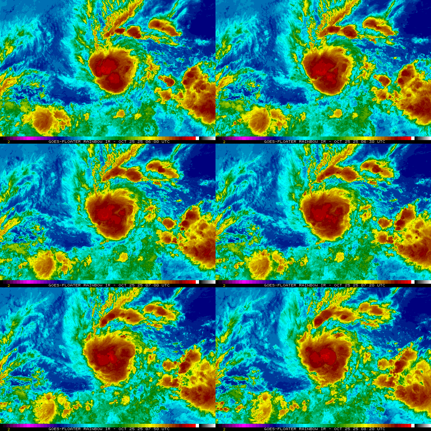
Satellite imagery shows deep convection expanding over the low-level
circulation center, with cloud-top temperatures near −80 C.
Subjective Dvorak Current Intensity estimates from TAFB and SAB are
in agreement at 2.5/35 kt, which is supported by the latest UW–CIMSS
objective estimates. Based on the improving satellite presentation
and these data, the depression has been upgraded to Tropical Storm
Sonia, with the initial intensity set at 35 kt.

Sonia has a brief window of opportunity to gradually strengthen over
the weekend while it remains over warm waters and within a moist,
low-shear environment. Strengthening should level off by Monday as
southwesterly vertical wind shear begins to increase. By Tuesday, a
combination of stronger shear, drier mid- to upper-level air, and
cooler sea-surface temperatures should induce a gradual weakening
trend. Simulated satellite imagery from the global models supports
this scenario, depicting convection diminishing by midweek. As a
result, Sonia is forecast to degenerate into a post-tropical remnant
low by day 4. The NHC intensity forecast remains very similar to the
previous one and continues to closely follow the consensus aids.

The initial motion is toward the west, or 275/8 kt, along the
southern side of a subtropical ridge that is expected to persist
through the first half of the weekend. A turn toward the northwest
is anticipated for a brief period late Sunday into early next week
as a weakness develops in the ridge in response to a mid-latitude
trough passing over the northern Pacific. A turn back toward the
west is then expected by Tuesday and into midweek as the ridge
restrengthens to the north. By day 5, Sonia is forecast to become
increasingly influenced by the low-level trade wind flow, which
should steer it southwestward. The latest NHC track forecast remains
close to the previous advisory and lies between the HCCA and
Google DeepMind solutions.


FORECAST POSITIONS AND MAX WINDS

INIT  25/0900Z 13.3N 117.6W   35 KT  40 MPH
12H  25/1800Z 13.4N 118.6W   40 KT  45 MPH
24H  26/0600Z 13.4N 119.5W   45 KT  50 MPH
36H  26/1800Z 13.6N 120.4W   50 KT  60 MPH
48H  27/0600Z 14.1N 121.0W   50 KT  60 MPH
60H  27/1800Z 14.6N 121.6W   50 KT  60 MPH
72H  28/0600Z 15.2N 122.4W   45 KT  50 MPH
96H  29/0600Z 15.5N 125.0W   30 KT  35 MPH...POST-TROP/REMNT LOW
120H  30/0600Z 14.8N 128.3W   25 KT  30 MPH...POST-TROP/REMNT LOW

$$
Forecaster Gibbs (CPHC)
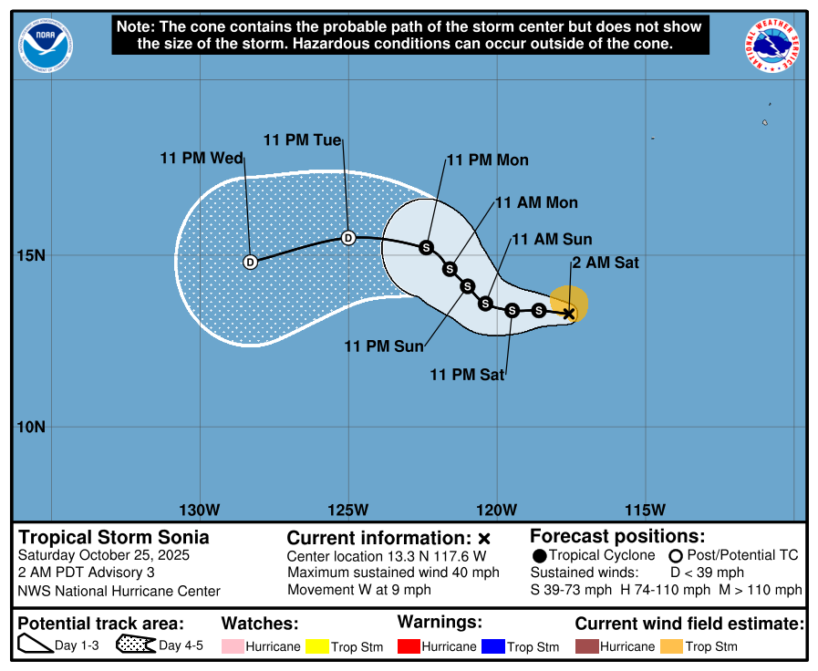
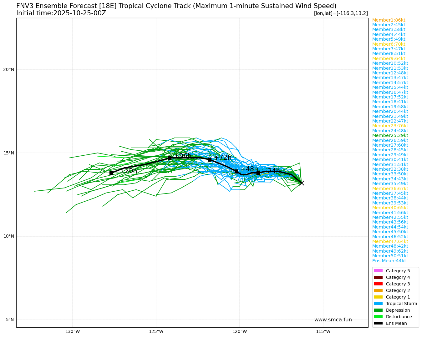
250833_5day_cone_with_line_and_wind.png
fnv3_18E_ensemble_2025102500.png
rb-animated.gif
回復

使用道具 舉報

簽到天數: 3311 天

[LV.Master]伴壇終老

king111807|2025-10-29 21:39 | 顯示全部樓層
NHC判定轉化為後熱帶氣旋

000
WTPZ43 KNHC 290832
TCDEP3

Post-Tropical Cyclone Sonia Discussion Number  19
NWS National Hurricane Center Miami FL       EP182025
200 AM PDT Wed Oct 29 2025

Sonia has succumbed to hostile environmental conditions, with
satellite imagery showing no deep convection near the low-level
center for about 15 hours.  Therefore, Sonia is being a declared
post-tropical cyclone.  The latest subjective satellite intensity
estimates from TAFB and SAB reflect this, deeming the system too
weak to classify.  A 0541 UTC Metop-B ASCAT pass revealed a large
area of 25-kt winds, with a peak wind vector of 26 kt.  Taking into
account the likelihood of some undersampling, the initial intensity
for the post-tropical remnant low of Sonia is set at 30 kt.

Sonia will continue moving westward during the next day or so,
steered by the low-level flow, while remaining embedded within a
hostile environment.  Regeneration of organized deep convection is
not expected, and the remnant low of Sonia is forecast to dissipate
by Thursday, if not sooner.

For additional information on the post-tropical remnant low please
see High Seas Forecasts issued by the National Weather Service,
under AWIPS header NFDHSFEPI, WMO header FZPN02 KWBC, and on the
web at ocean.weather.gov/shtml/NFDHSFEPI.php

FORECAST POSITIONS AND MAX WINDS

INIT  29/0900Z 15.3N 126.1W   30 KT  35 MPH...POST-TROPICAL
12H  29/1800Z 15.2N 127.6W   25 KT  30 MPH...POST-TROP/REMNT LOW
24H  30/0600Z 14.7N 129.9W   25 KT  30 MPH...POST-TROP/REMNT LOW
36H  30/1800Z...DISSIPATED

$$
Forecaster Jelsema (CPHC)
290832_5day_cone_with_line_and_wind.png
rb-animated.gif
回復

使用道具 舉報

快速回覆
您需要登錄後才可以回帖 登錄 | 立即加入

本版積分規則

本平台僅供學術討論之用,預報應以氣象局為準

威普網站虛擬主機贊助公司

臺灣第一個天氣類型社群平台 即時天氣資訊、精準颱風動態

線上客服
FB傳送訊息
廣告行銷
精準行銷 物超所值
官方粉專
發佈 快速回復 返回頂部 返回列表