|
|
 krichard2011|2017-4-7 20:58
|
顯示全部樓層
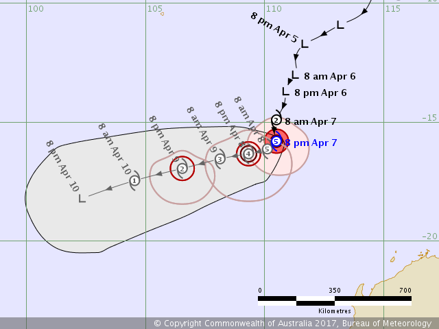
Ernie 達成了幾乎不可能的任務
在短短的不到24小時 從一級熱帶氣旋 猛爆增強到 5級強烈熱帶氣

- IDW27600
- TROPICAL CYCLONE TECHNICAL BULLETIN: AUSTRALIA - WESTERN REGION
- Issued by PERTH TROPICAL CYCLONE WARNING CENTRE
- at: 1202 UTC 07/04/2017
- Name: Severe Tropical Cyclone Ernie
- Identifier: 26U
- Data At: 1200 UTC
- Latitude: 15.8S
- Longitude: 110.5E
- Location Accuracy: within 15 nm [30 km]
- Movement Towards: south [180 deg]
- Speed of Movement: 5 knots [8 km/h]
- Maximum 10-Minute Wind: 110 knots [205 km/h]
- Maximum 3-Second Wind Gust: 155 knots [285 km/h]
- Central Pressure: 936 hPa
- Radius of 34-knot winds NE quadrant: 60 nm [110 km]
- Radius of 34-knot winds SE quadrant: 90 nm [165 km]
- Radius of 34-knot winds SW quadrant: 80 nm [150 km]
- Radius of 34-knot winds NW quadrant: 60 nm [110 km]
- Radius of 48-knot winds NE quadrant: 30 nm [55 km]
- Radius of 48-knot winds SE quadrant: 30 nm [55 km]
- Radius of 48-knot winds SW quadrant: 30 nm [55 km]
- Radius of 48-knot winds NW quadrant: 30 nm [55 km]
- Radius of 64-knot winds: 15 nm [30 km]
- Radius of Maximum Winds: 15 nm [30 km]
- Dvorak Intensity Code: T6.5/6.5/D4.0/24HRS STT:D1.0/6HRS
- Pressure of outermost isobar: 1006 hPa
- Radius of outermost closed isobar: 100 nm [185 km]
- FORECAST DATA
- Date/Time : Location : Loc. Accuracy: Max Wind : Central Pressure
- [UTC] : degrees : nm [km]: knots[km/h]: hPa
- +06: 07/1800: 16.0S 110.4E: 025 [050]: 115 [215]: 930
- +12: 08/0000: 16.1S 110.1E: 040 [070]: 120 [220]: 926
- +18: 08/0600: 16.2S 109.8E: 050 [095]: 115 [215]: 930
- +24: 08/1200: 16.3S 109.3E: 065 [120]: 105 [195]: 940
- +36: 09/0000: 16.5S 108.1E: 085 [155]: 080 [150]: 966
- +48: 09/1200: 16.9S 106.5E: 105 [190]: 055 [100]: 986
- +60: 10/0000: 17.5S 104.5E: 120 [225]: 040 [075]: 996
- +72: 10/1200: 18.2S 102.3E: 140 [265]: 030 [060]: 1000
- +96: 11/1200: 20.1S 98.8E: 185 [345]: 025 [045]: 1005
- +120: 12/1200: : : :
- REMARKS:
- Severe Tropical Cyclone Ernie was located using all the types of satellite
- imagery, notably visible. The position has low uncertainty due to development of
- an eye.
- Dvorak Analysis: An eye pattern in EIR provides DT of 7.5 using cold medium grey
- surround and a warm medium grey eye. Visible analysis also results in a 7.5 eye
- pattern. Whilst this technically is breaking constraints over 24 hours, due to
- the consistency of DTs ranging between 6.5 to 7.5 over the past four hours the
- decision to have the system strength based on very rapid intensification due to
- satellite observations in the last 6 to 9 hours was made. CIMSS ADT has been
- reporting similar T numbers [between 6 and 7] with FTs also limited to 6.0 due
- to constraints. NESDIS ADT lagged in transitioning to an eye pattern and
- subsequently has FT numbers about 5.6. Satcon winds estimated 105 kt sustained
- winds. Intensity is set at 110 knots with a small radius of max winds, though
- with gales in a more extensive area in southern quadrants.
- SSTs are 29-30C and ocean heat content is favourable.
- CIMSS continues to show good poleward outflow and upper divergence. CIMSS shear
- has further decreased in the last 6 hours to be less than 10 knots.
- Over the next 12 to 24 hours, conditions will remain favourable with low
- vertical wind shear, high moisture and warm SSTs. As a mid level ridge develops
- later on Saturday and begins influencing the steering, the presence of dry air
- and increasing shear should cause the system to weaken, however, gales may
- persist in southern quadrants due to the pressure gradient associated with a
- ridge of high pressure to the south.
- The system is being steered towards the south due to an upper trough passing to
- the south. On Saturday, a building mid level ridge will steer the system towards
- the west-southwest. The majority of NWP guidance is consistent with the forecast
- track.
- Severe Tropical Cyclone Ernie is not expected to produce gales at Christmas
- Island or the WA mainland.
- Copyright Commonwealth of Australia
- ==
- The next bulletin for this system will be issued by: 07/1930 UTC by Perth TCWC.
JTWC 這樣才105KT? 我也是醉了...
- SH, 15, 2017040712, , BEST, 0, 158S, 1104E, 105, 954, TY, 64, NEQ, 20, 30, 25, 20, 1007, 170, 10, 0, 10, S, 0, , 0, 0, ERNIE, D,
|
|