開啟輔助訪問
 找回密碼
 立即加入

06E.Fernanda 中心裸露 進入中太 持續減弱

查看數: 16651 評論數: 25 收藏 0切换到帖子模式
    組圖打開中,請稍候......
發佈時間: 2017-7-11 09:51

正文摘要:

  四級颶風   編號:06 E 名稱:Fernanda   基本資料   擾動編號日期:2017 年 07 月 11 日 09 時 命名日期  :2017 年 07 月 12 日 20 時 撤編日期  :2017 年 07 月 ...

蜜露 發表於 2017-8-3 20:15


費爾南達的巔峰 . 強度或許和諾盧是同個等級
20170715.0000.goes-15.ir.06E.FERNANDA.125kts.948mb.10.7N.120.2W.100pc.jpg


20170715.0000.goes-15.ircolor.06E.FERNANDA.125kts.948mb.10.7N.120.2W.100pc.jpg


20170715.0101.goes15.x.wv1km.06EFERNANDA.125kts-948mb-107N-1202W.89pc.jpg


t02436 發表於 2017-7-23 11:22
隨著第44報(最終報07/22 21Z)的發出,Fernanda正式結束長達10天半的熱帶氣旋生命史。
WTPA41 PHFO 222043
TCDCP1

Post-Tropical Cyclone Fernanda Discussion Number  44
NWS Central Pacific Hurricane Center Honolulu HI   EP062017
1100 AM HST Sat Jul 22 2017

Due to strong southwesterly vertical wind shear, only limited and
sporadic convection has been noted in the northern semicircle of
the poorly-defined low-level circulation center of Fernanda over
the past several hours. This convection has not been sufficiently
persistent for the system to continue to be deemed a tropical
cyclone, and Fernanda is now post-tropical. The initial intensity is
estimated to be 30 kt, based heavily on last night's ASCAT pass,
with these winds likely confined to the northern semicircle.

The initial motion estimate for this advisory is 285/8 kt. The
increasingly shallow low is expected to continue on a west-northwest
to west track within the low- to mid-level trade wind flow supported
by a ridge well to the north, with some increase in forward speed.
Although the forecast track takes the system over warmer waters,
the strong vertical wind shear will persist, due to a longwave
trough aloft to the northwest. Fernanda is expected to dissipate
to a trough after 36 hours, with this solution supported by
virtually all of the dynamical and statistical guidance.

This will be the final advisory issued by the Central Pacific
Hurricane Center on Fernanda.
For additional information on the
remnant low, see High Seas Forecasts issued by the National Weather
Service under AWIPS header HFOHSFNP and WMO header FZPN40 PHFO.


FORECAST POSITIONS AND MAX WINDS

INIT  22/2100Z 19.5N 147.4W   30 KT  35 MPH...POST-TROP/REMNT LOW
12H  23/0600Z 19.9N 148.9W   25 KT  30 MPH...POST-TROP/REMNT LOW
24H  23/1800Z 20.3N 151.5W   25 KT  30 MPH...POST-TROP/REMNT LOW
36H  24/0600Z 20.5N 154.0W   20 KT  25 MPH...POST-TROP/REMNT LOW
48H  24/1800Z...DISSIPATED

$$
Forecaster Birchard

EP062017_5day_cone_with_line_44.png

vis-animated.gif
t02436 發表於 2017-7-21 11:41
CPHC今年第一份熱帶氣旋報告,持續減弱中。
Tropical Storm Fernanda Public Advisory Number 37
Issued at 500 PM HST Thu Jul 20 2017
WTPA31 PHFO 210236
TCPCP1

BULLETIN
Tropical Storm Fernanda Advisory Number 37
NWS Central Pacific Hurricane Center Honolulu HI EP062017
500 PM HST Thu Jul 20 2017

...FERNANDA CONTINUES TO WEAKEN IN THE CENTRAL PACIFIC...


SUMMARY OF 500 PM HST...0300 UTC...INFORMATION
----------------------------------------------
Location: 18.4N 141.4W
ABOUT 900 MI...1445 KM E OF HILO HAWAII
ABOUT 1090 MI...1755 KM E OF HONOLULU HAWAII
Maximum sustained winds: 50 MPH...85 KM/H
Present movement: W or 280 degrees AT 12 MPH...19 KM/H
Minimum central pressure: 1000 MB...29.53 INCHES


WATCHES AND WARNINGS
--------------------
There are no coastal watches or warnings in effect.


DISCUSSION AND 48-HOUR OUTLOOK
------------------------------
At 500 PM HST (0300 UTC), the center of Tropical Storm Fernanda was
located near latitude 18.4 North, longitude 141.4 West. Fernanda is
moving toward the west near 12 mph (19 km/h), and a general motion
toward the west-northwest is expected during the next couple of
days.

Maximum sustained winds are near 50 mph (85 km/h) with higher gusts.
Additional weakening is forecast during the next 48 hours, and
Fernanda is expected to become a tropical depression on Friday.

Tropical-storm-force winds extend outward up to 80 miles (130 km)
from the center.

The estimated minimum central pressure is 1000 mb (29.53 inches).


HAZARDS AFFECTING LAND
----------------------
None.


NEXT ADVISORY
-------------
Next complete advisory at 1100 PM HST.

$$
Forecaster Kodama

07210300_5-day with line.png

vis_lalo-animated.gif
WTPA41 PHFO 210240
TCDCP1

Tropical Storm Fernanda Discussion Number  37
NWS Central Pacific Hurricane Center Honolulu HI   EP062017
500 PM HST Thu Jul 20 2017

Most of the deep convection near the center of Fernanda has
dissipated leaving an exposed low level circulation center
surrounded by mostly low- and mid-level clouds. The remaining
thunderstorms are confined to an outer rainband more than 60 nm
north of the center. The initial intensity is 45 kt which is
slightly weaker than the previous advisory. This may be conservative
but an ASCAT pass from 1936 UTC sampled the northwestern portion of
the circulation and found 40 kt. Subjective Dvorak estimates from
PHFO and SAB came in at 35 kt but this may be too aggressive a drop
at this time.

The initial motion for this package is 280/10 kt with steering
increasingly dictated by the low level flow. The main dynamical
aids show a fair amount of spread. The GFS, and to a lesser
degree HWRF, continue to hold on to a stronger and deeper system
which results in a more northwestward track. This doesn't appear
to be reasonable given the environmental circumstances. Thus, the
forecast track leans more toward the ECMWF solution and is close to
the previous forecast, keeping Fernanda on a general westward to
west-northwestward motion through the forecast period.

Fernanda is tracking over waters near 25C. Along the forecast track,
sea surface temperature are to remain in the 25C to 26C range. The
cyclone is also expected to stay within strong vertical shear
conditions of about 25 to 35 kt through the next 3 days.
Although some deep convection may occasionally flare up near
the center, the more likely outcome under these environmental
conditions is for Fernanda to continue to weaken and eventually
dissipate. This expectation is consistent with the SHIPS
guidance. The forecast calls for continued weakening with Fernanda
becoming a remnant low during the next 24 to 36 hours, then opening
up to a trough after 72 hours.


FORECAST POSITIONS AND MAX WINDS

INIT  21/0300Z 18.4N 141.4W   45 KT  50 MPH
12H  21/1200Z 18.8N 142.9W   35 KT  40 MPH
24H  22/0000Z 19.3N 144.8W   30 KT  35 MPH
36H  22/1200Z 19.9N 146.6W   25 KT  30 MPH...POST-TROP/REMNT LOW
48H  23/0000Z 20.5N 148.4W   25 KT  30 MPH...POST-TROP/REMNT LOW
72H  24/0000Z 21.8N 153.0W   25 KT  30 MPH...POST-TROP/REMNT LOW
96H  25/0000Z...DISSIPATED

$$
Forecaster Kodama
t02436 發表於 2017-7-21 00:22
裸露的中心已經來到西經139度,將在00Z以前進入中太平洋。
000
WTPZ41 KNHC 201440
TCDEP1

Tropical Storm Fernanda Discussion Number  35
NWS National Hurricane Center Miami FL       EP062017
800 AM PDT Thu Jul 20 2017

Since the last advisory, Fernanda has become significantly sheared
with the low-level center now exposed to the southwest of a rather
small area of deep convection.  The initial intensity is reduced to
55 kt based on various satellite intensity estimates, and it is
possible that this is generous.  While the sea surface temperatures
along the forecast track should increase, a combination of
continued moderate-to-strong shear and entrainment of dry air
should keep Fernanda steadily weakening through the forecast
period. The cyclone is forecast to weaken to a depression in 24-36
h and degenerate into a remnant low shortly thereafter, with the
new intensity forecast being an update of the previous forecast.

The now-exposed center is a little west of the previous advisory
position, and the initial motion is now 285/8.  Fernanda is
expected to move generally west-northwestward through the forecast
period as the increasingly weak and shallow vortex is steered by
the low-level trade winds.  The new forecast track is parallel to,
but south of, the previous track based on the current position and
motion.  However, it lies to the north of the consensus models and
the center of the guidance envelope, and if current trends continue
some additional southward adjustment of the track could occur later
today.


FORECAST POSITIONS AND MAX WINDS

INIT  20/1500Z 18.2N 139.2W   55 KT  65 MPH
12H  21/0000Z 18.6N 140.6W   45 KT  50 MPH
24H  21/1200Z 19.0N 142.4W   35 KT  40 MPH
36H  22/0000Z 19.5N 144.1W   30 KT  35 MPH
48H  22/1200Z 20.1N 145.8W   25 KT  30 MPH...POST-TROP/REMNT LOW
72H  23/1200Z 21.5N 149.5W   25 KT  30 MPH...POST-TROP/REMNT LOW
96H  24/1200Z 22.5N 154.5W   25 KT  30 MPH...POST-TROP/REMNT LOW
120H  25/1200Z 24.0N 160.5W   20 KT  25 MPH...POST-TROP/REMNT LOW

$$
Forecaster Beven

144303_5day_cone_with_line.png

rbtop_lalo-animated.gif

NET 發表於 2017-7-18 15:46
本帖最後由 NET 於 2017-7-18 15:49 編輯

截圖時間 2017 07 18 0800


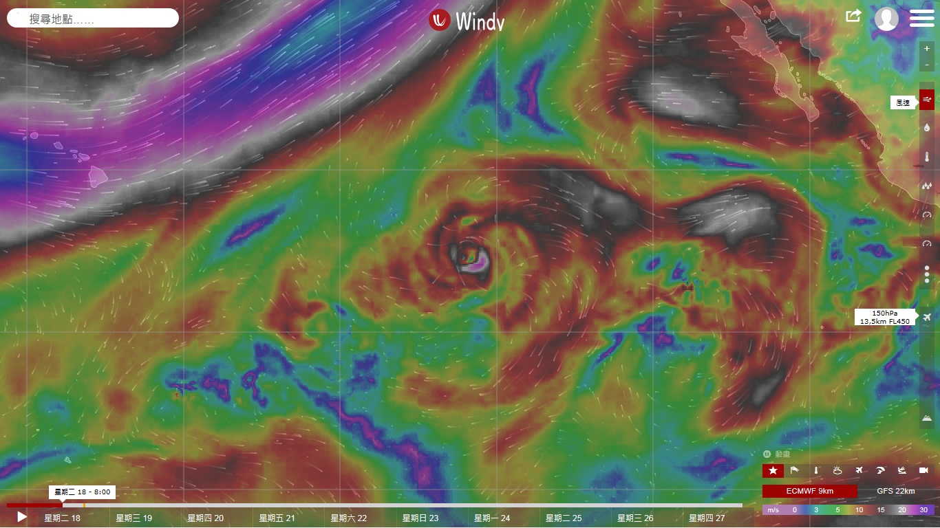
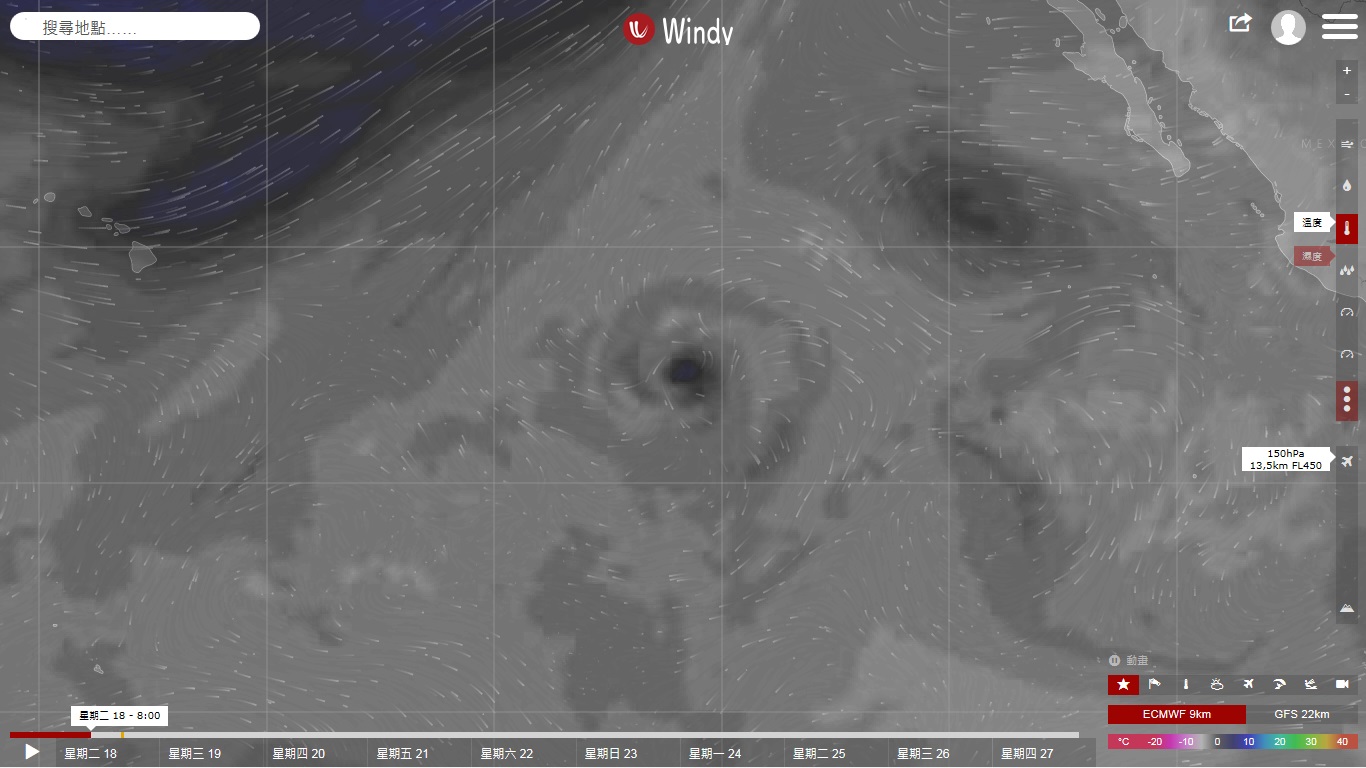
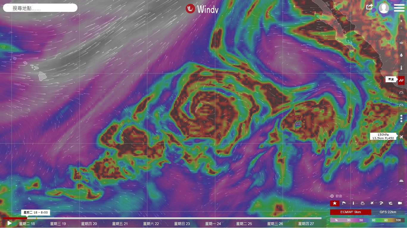
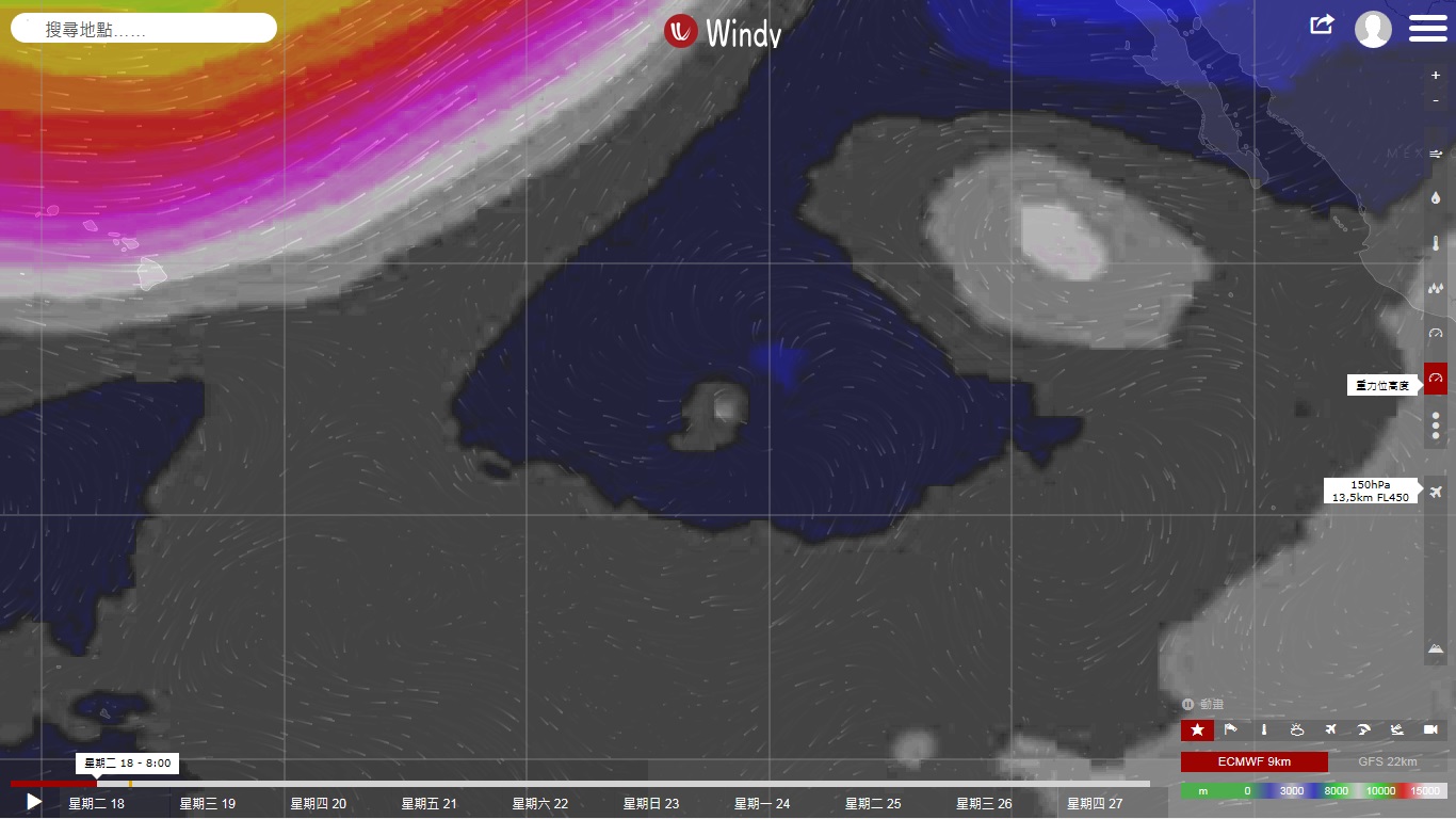
這是我今年到現在為止看到最優美、也是最強的高空福散。

本平台僅供學術討論之用,預報應以氣象局為準

威普網站虛擬主機贊助公司

臺灣第一個天氣類型社群平台 即時天氣資訊、精準颱風動態

線上客服
FB傳送訊息
廣告行銷
精準行銷 物超所值
官方粉專
發佈 快速回復 返回頂部 返回列表