開啟輔助訪問
 找回密碼
 立即加入

15L.Maria 加速朝東北前進

簽到天數: 582 天

[LV.9]以壇為家II

蜜露|2017-9-22 13:12 | 顯示全部樓層
本帖最後由 蜜露 於 2017-9-22 19:21 編輯

bandicam 2017-09-21 22-38-30-614.jpg

bandicam 2017-09-21 22-38-39-003.jpg

DRONE_SURVEYS_CATANO_AREA_OUTSIDE_SAN_JUAN_WEB_1_1280x720_17168965566.jpg
bandicam 2017-09-21 22-38-59-740.jpg


1071445.jpg

_97952773_041862873.jpg
1071439.jpg


bandicam 2017-09-21 22-39-37-734.jpg


bandicam 2017-09-21 22-39-58-431.jpg


flooding-puerto-rico.jpg

19.jpg

bandicam 2017-09-22 12-58-41-835.jpg


bandicam 2017-09-22 12-58-47-421.jpg


波多黎各災情慘重 , 全島強風+洪水島上兩座雷達都被風吹走了 .
地面觀測站全部故障 . 全島沒有電

瑪麗亞颶風登陸時,在聖胡安引起了12.8米高的風暴潮(12米約40呎海嘯)
超越了之前卡翠娜颶風8米和海燕颱風6~7米的紀錄.  南部瓜亞瑪也有9米.
ciap4_hg.png
而據說風暴潮最高還錄到了24米(79呎....)的附近一個村落Toa Baja .  最新的影像也出來了 ,
一樓整個都淹沒了 . (24米約311大海嘯平均高度) 但沒被證實. 圖表是27呎 = 約8米

toap4_hg.png

nasp4_hg.png

聖胡安、南卡羅萊納、Guaynabo、Dorado、龐塞、瓜亞瑪、Toa Baja是暴洪比較嚴重的地方.
傷亡還在釐清.

全島停電有幾個地區甚至要半年都沒電可用.

另外多米尼克最新是14人死亡 . 90%房屋遭毀壞.


點評

更新. 單位記錯 最高是42呎 約13米  發表於 2017-9-22 19:22
看起來台灣真的是比較有本錢...但是這幾個IRMA MARIA都太兇了  發表於 2017-9-22 16:20

評分

參與人數 1水氣能量 +10 收起 理由
jwpk9899 + 10 天那...

查看全部評分

回復

使用道具 舉報

簽到天數: 582 天

[LV.9]以壇為家II

蜜露|2017-9-21 22:19 | 顯示全部樓層
本帖最後由 蜜露 於 2017-9-22 13:13 編輯

目前已經有多米尼克的空拍了

170920-hurricane-maria-dominica-se-440p_d4739e15735137f0af5af23ac220534d.nbcnews.jpg


f_cdemaaerial_170920.nbcnews-ux-1080-600.jpg


ss-170920-hurricane-maria-dominica-mn-1450_3411a256a6d773f66eb15a74389c69f3.nbcn.jpg


這是Cat.5 140Kts的風毀 , 算是滿嚴重的
(不過呢~如果你們有看過Irma的風毀 Cat.5 160Kts  其實瑪麗亞還不是最慘)


點評

Irma和Maria差在95%和70%房屋的毀滅程度.  發表於 2017-9-22 02:09
Cat.5 160kts以上就和電影災難片差不多了 所以Irma和Haiyan在陸地那個毀壞很可怕  發表於 2017-9-22 02:05
Haiyan的Cat.5 170Kts的風毀應該是傳說電影災難片中誇張無人道毀滅真實反映。  發表於 2017-9-22 00:12

評分

參與人數 1水氣能量 +10 收起 理由
jwpk9899 + 10

查看全部評分

回復

使用道具 舉報

簽到天數: 3279 天

[LV.Master]伴壇終老

t02436|2017-9-21 18:21 | 顯示全部樓層
開出一個巨眼:o
FORECAST POSITIONS AND MAX WINDS

INIT  21/0900Z 19.6N  68.4W  100 KT 115 MPH
12H  21/1800Z 20.5N  69.3W  105 KT 120 MPH
24H  22/0600Z 21.6N  70.4W  110 KT 125 MPH
36H  22/1800Z 22.9N  71.1W  105 KT 120 MPH
48H  23/0600Z 24.3N  71.7W  100 KT 115 MPH
72H  24/0600Z 27.4N  72.3W  100 KT 115 MPH
96H  25/0600Z 30.0N  72.0W   90 KT 105 MPH
120H  26/0600Z 32.5N  70.5W   80 KT  90 MPH

085021_5day_cone_with_line.png

20170921.0601.gw1.89pct89h89v.15L.MARIA.100kts.959mb.19.4N.68.1W.82pc.jpg

GOES09452017264jfphIG.jpg

rbtop-animated.gif
回復

使用道具 舉報

簽到天數: 582 天

[LV.9]以壇為家II

蜜露|2017-9-21 14:40 | 顯示全部樓層
本帖最後由 蜜露 於 2017-9-21 15:03 編輯

有說法說這是85年來(1928颶風)登陸波多黎各第二強的颶風.

根據消息指出全島面臨了風暴潮的襲擊 ,  其中聖胡安的風暴潮甚至錄到了12米似乎被證實了
(遠高過海燕颱風的7米 、卡翠娜颶風的8米紀錄)

而另一地多拉多附近的Rio de la Plata河流據說還錄到24米  , 約79呎 (這是311大海嘯的級別).
還在查證. 但這個我覺得很誇張....懷疑故障.
ac60afc379310a55be1d63e3bc4543a982261045.jpg


全島造成100%斷電狀態, 也沒有辦法通訊網路 .. 當地目前夜晚,拯救相當困難。

但目前有部分畫面指出,可靠性似乎還滿高。


拍的地方是波多黎各島各地方風暴潮造成洪水
聖胡安、南卡羅來納、瓜依納沃、龐塞、瓜亞瑪、多拉多、Vega Baja、Orocovis、Cidia、Manati。


評分

參與人數 1水氣能量 +10 收起 理由
jwpk9899 + 10

查看全部評分

回復

使用道具 舉報

簽到天數: 3279 天

[LV.Master]伴壇終老

t02436|2017-9-21 09:59 | 顯示全部樓層
以對角線穿越波多黎各可以說是大傷,00Z評價95節,氣壓不斷回升中
SUMMARY OF 800 PM AST...0000 UTC...INFORMATION
----------------------------------------------
LOCATION...39.4N 68.6W
ABOUT 145 MI...235 KM SSE OF NANTUCKET MASSACHUSETTS
MAXIMUM SUSTAINED WINDS...65 MPH...100 KM/H
PRESENT MOVEMENT...NE OR 55 DEGREES AT 8 MPH...13 KM/H
MINIMUM CENTRAL PRESSURE...979 MB...28.91 INCHES

235427.png

recon_AF302-1115A-MARIA.png

持續重整,風眼又轉出來了
20170920.2308.f18.91pct91h91v.15L.MARIA.95kts.959mb.18.6N.67W.055pc.jpg

GOES01152017264Zfbm50.jpg

rbtop-animated.gif

點評

錯!應該是以實測風速女王2015年PATRICIA的標準為基底,量身訂做全球熱帶氣旋防風防震最強終極氣象雷達。  發表於 2017-9-22 00:08
以後業界標準測風雷達 皆以海燕為標準下去製作XD  發表於 2017-9-21 12:32
颱風形狀的風眼~  發表於 2017-9-21 11:43
回復

使用道具 舉報

簽到天數: 3279 天

[LV.Master]伴壇終老

t02436|2017-9-21 02:18 | 顯示全部樓層
18Z根據飛機實測已判定中心出海,強度定在100節。
BULLETIN
Hurricane Maria Intermediate Advisory Number 18A
NWS National Hurricane Center Miami FL       AL152017
200 PM AST Wed Sep 20 2017

...AIR FORCE HURRICANE HUNTER PLANE FINDS MARIA'S CENTER JUST
OFFSHORE OF THE NORTHWESTERN COAST OF PUERTO RICO...


SUMMARY OF 200 PM AST...1800 UTC...INFORMATION
----------------------------------------------
LOCATION...18.5N 66.9W
ABOUT 15 MI...20 KM W OF ARECIBO PUERTO RICO
ABOUT 95 MI...155 KM E OF PUNTA CANA DOMINICAN REPUBLIC
MAXIMUM SUSTAINED WINDS...115 MPH...185 KM/H
PRESENT MOVEMENT...NW OR 305 DEGREES AT 12 MPH...19 KM/H
MINIMUM CENTRAL PRESSURE...961 MB...28.38 INCHES

180045_5day_cone_with_line.png

recon_AF305-0915A-MARIA.png

rgb0.gif

回復

使用道具 舉報

簽到天數: 3198 天

[LV.Master]伴壇終老

king111807|2017-9-20 23:27 | 顯示全部樓層
21616282_2051165131564150_1691227336062611986_n.jpg
【Maria颶風登陸波多黎各 強度略為減弱】
今年全球第二強的熱帶氣旋Maria在今日下午6點15分從波多黎各登陸,實測風速高達135節,相當於台灣的強烈颱風。由於目前颶風中心在陸地,整體的強度也有減弱。
受到Maria颶風的影響,多米尼克目前初步統計有7人死亡,同時也造成多米尼克多處土石流,災情相當慘重。
目前Maria颶風已經從波多黎各東南部沿海登陸,中心在東南部的卡耶伊附近,估計在今天晚上至明日清晨中心會出海。
Maria颶風在波多黎各也帶來許多災害,據目前最新的訊息顯示,當地的氣象雷達也被Maria颶風吹走。由於當地目前正在Irma颶風的復原工作,Maria颶風所帶來的災後復原將會是接下來所面臨的難題。


點評

兩個雷達站都被摧毀了,沒東西可看,剩雲圖  發表於 2017-9-21 01:03
回復

使用道具 舉報

簽到天數: 3279 天

[LV.Master]伴壇終老

t02436|2017-9-20 23:18 | 顯示全部樓層
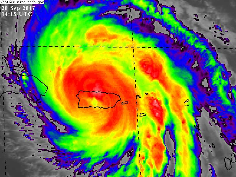
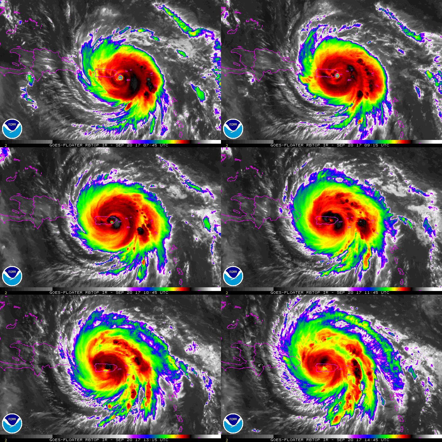
15Z減弱到120節,中心看來快出海了,波多黎各雷達跟測站無一倖免,慘...
接下來因為雷達站毀損以及風眼填塞,每小時的定位報將取消直到出海飛機實測啟動後。
ZCZC MIATCDAT5 ALL
TTAA00 KNHC DDHHMM

Hurricane Maria Discussion Number  18
NWS National Hurricane Center Miami FL       AL152017
1100 AM AST Wed Sep 20 2017

The last radar image from the San Juan WSR-88D was received at 0950
UTC when Maria's eye was located only about 5 n mi off the
southeastern coast of Puerto Rico.
  Subsequent 1-minute imagery from
the GOES-16 satellite, as well as surface observations, indicate
that the eye made landfall a little south of Yabucoa Harbor, Puerto
Rico, around 1015 UTC.  Now that the center is moving over the
mountainous terrain of the island, the eye has become cloud filled,
and the infrared satellite presentation has degraded. Without radar
velocity data, the initial intensity is incredibly uncertain, but my
best guess is 120 kt based on a typical inland decay rate.
  Maria's
center is expected to move off the northern coast of Puerto Rico
soon, and an Air Force Reserve reconnaissance aircraft is scheduled
to intercept the center early this afternoon and provide a better
estimate of how much Maria has weakened.


The initial motion is northwestward, or 305/10 kt.  This
northwestward motion is forecast to continue for the next 48 hours,
followed by a turn toward the north by days 4 and 5, while Maria
moves between a mid-level high centered southeast of Bermuda and a
broad trough extending from Tropical Storm Jose southwestward into
the Gulf of Mexico.  The track guidance is tightly clustered this
cycle, and there were no significant changes made to the NHC
forecast track.

Once Maria moves off the coast of Puerto Rico, it will take some
time for the structure to reorganize over the warm waters of the
Atlantic Ocean.  However, the shear is expected to be less than 10
kt for the next 24-36 hours, and Maria has an opportunity to
restrengthen a bit over that time period.  After 36 hours, a gradual
increase in shear is likely to lead to a commensurate gradual
decrease in the hurricane's intensity through the end of the
forecast period.  Since the SHIPS model, in particular, responds to
the favorable conditions for intensification, the NHC intensity
forecast lies just above the intensity consensus through much of the
forecast period.

Since we don't have radar imagery from San Juan, and the eye has
become cloud filled in satellite imagery, the hourly position
updates are being discontinued.


KEY MESSAGES:

1. Maria's core is moving over Puerto Rico, with life-threatening
wind, storm surge, and rainfall impacts continuing over the
island. Everyone in Puerto Rico should follow advice from local
officials to avoid life-threatening flooding from storm surge and
rainfall. A Hurricane Warning remains in effect for the Virgin
Islands, but conditions should gradually improve there later today.

2. Wind speeds atop and on the windward sides of hills and mountains
and on high-rise buildings could be much stronger than the
near-surface winds indicated in this advisory.

3. A Hurricane Warning is also in effect for the northern coast of
the Dominican Republic, the Turks and Caicos Islands and the
southeastern Bahamas, where Maria is expected to bring dangerous
wind, storm surge, and heavy rainfall.


FORECAST POSITIONS AND MAX WINDS

INIT  20/1500Z 18.4N  66.5W  120 KT 140 MPH...OVER PUERTO RICO
12H  21/0000Z 19.2N  67.6W  120 KT 140 MPH
24H  21/1200Z 20.2N  69.0W  125 KT 145 MPH
36H  22/0000Z 21.2N  70.1W  125 KT 145 MPH
48H  22/1200Z 22.4N  71.0W  120 KT 140 MPH
72H  23/1200Z 25.3N  72.4W  110 KT 125 MPH
96H  24/1200Z 28.5N  73.0W  100 KT 115 MPH
120H  25/1200Z 31.5N  73.0W   90 KT 105 MPH

$$
Forecaster Berg

NNNN
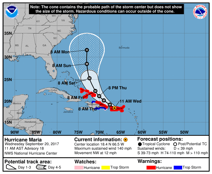
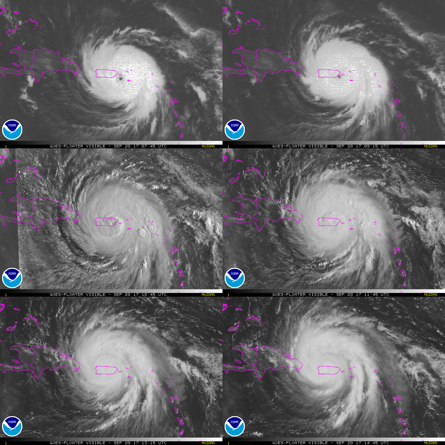
150028_5day_cone_with_line.png

GOES14152017263P08KOD.jpg

rbtop-animated.gif

vis-animated.gif

回復

使用道具 舉報

快速回覆
您需要登錄後才可以回帖 登錄 | 立即加入

本版積分規則

本平台僅供學術討論之用,預報應以氣象局為準

威普網站虛擬主機贊助公司

臺灣第一個天氣類型社群平台 即時天氣資訊、精準颱風動態

線上客服
FB傳送訊息
廣告行銷
精準行銷 物超所值
官方粉專
發佈 快速回復 返回頂部 返回列表