開啟輔助訪問
 找回密碼
 立即加入

15L.Maria 加速朝東北前進

簽到天數: 601 天

[LV.9]以壇為家II

霧峰追風者|2017-9-17 06:16 | 顯示全部樓層
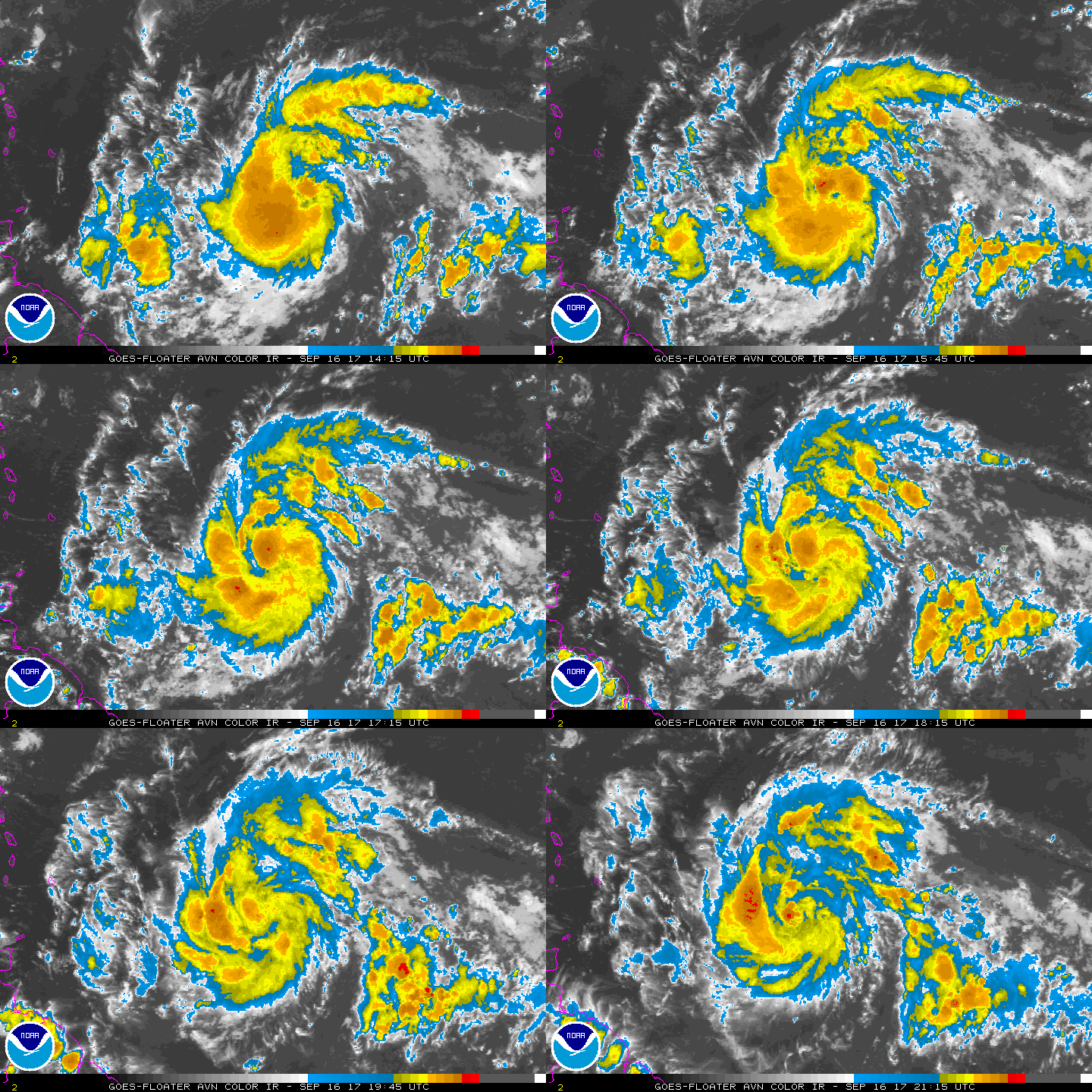
NHC 21Z命名"Maria",命名報強度45kt,目前巔峰上看三級颶風( 105kt ),又要影響背風群島。
000
WTNT45 KNHC 162038
TCDAT5

Tropical Storm Maria Discussion Number   2
NWS National Hurricane Center Miami FL       AL152017
500 PM AST Sat Sep 16 2017

Satellite images indicate that the system located several hundred
miles east of the Lesser Antilles has become much better organized
throughout the day.  The low-level center of circulation is now
well defined, and banding features have become better established in
all quadrants.  The initial wind speed is increased to 45 kt, in
agreement with a Dvorak classification from TAFB.  This makes the
system a tropical storm, Maria becomes the thirteenth named storm
in the Atlantic basin this season.

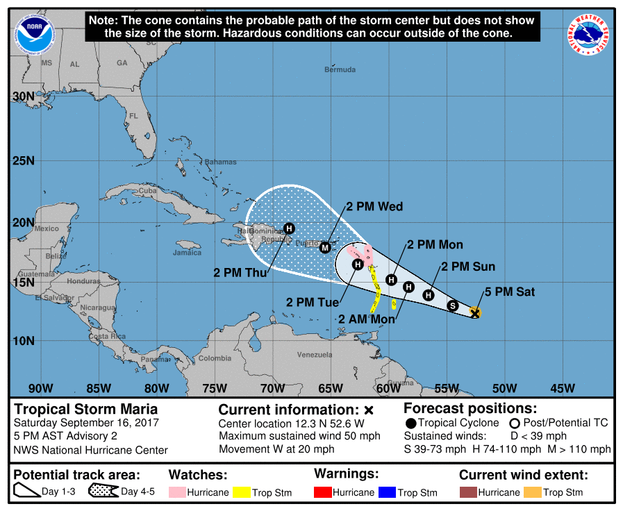
Maria is moving quickly westward at 17 kt on the south side of a
mid-level ridge.  This ridge is expected to remain in place but
weaken some, which should cause Maria to move west-northwestward at
a progressively slower pace through the forecast period.  The
models are in fair agreement, and the NHC official track forecast
is closest to the HCCA model.  This forecast takes the core of
Maria near the Leeward Islands in 48 to 72 hours, and close to the
Virgin Islands and Puerto Rico in about 4 days.

The tropical storm is located within conducive environmental
conditions of low wind shear, high amounts of moisture, and over
warm 29 deg C SSTs.  Since these conditions are not expected to
change much, steady or even rapid strengthening is likely during the
next 3 to 4 days.  Slight weakening is predicted by the end of the
forecast period due to some land interaction and a slight increase
in wind shear.  The NHC intensity forecast is raised significantly
from the previous one to come into better agreement with the latest
guidance.

KEY MESSAGES:

1. Maria is expected to strengthen and affect portions of the
Leeward Islands as a hurricane early next week, bringing dangerous
wind, storm surge and rainfall hazards.  Hurricane and tropical
storm watches have been issued for portions of the Lesser Antilles,
and additional watches will likely be issued tonight and Sunday.

2. Maria could also affect the British and U.S. Virgin Islands and
Puerto Rico by mid week as a dangerous major hurricane, and
hurricane watches could be issued for these islands as early as
Sunday.  Interests in these areas should monitor the progress of
Maria and follow any advice given by local officials.

FORECAST POSITIONS AND MAX WINDS

INIT  16/2100Z 12.3N  52.6W   45 KT  50 MPH
12H  17/0600Z 13.0N  54.5W   55 KT  65 MPH
24H  17/1800Z 13.9N  56.6W   65 KT  75 MPH
36H  18/0600Z 14.6N  58.3W   70 KT  80 MPH
48H  18/1800Z 15.2N  59.8W   80 KT  90 MPH
72H  19/1800Z 16.5N  62.7W   95 KT 110 MPH
96H  20/1800Z 17.9N  65.5W  105 KT 120 MPH
120H  21/1800Z 19.5N  68.6W   95 KT 110 MPH

$$
Forecaster Cangialosi
204552_5day_cone_no_line_and_wind.png avn-animated (2).gif

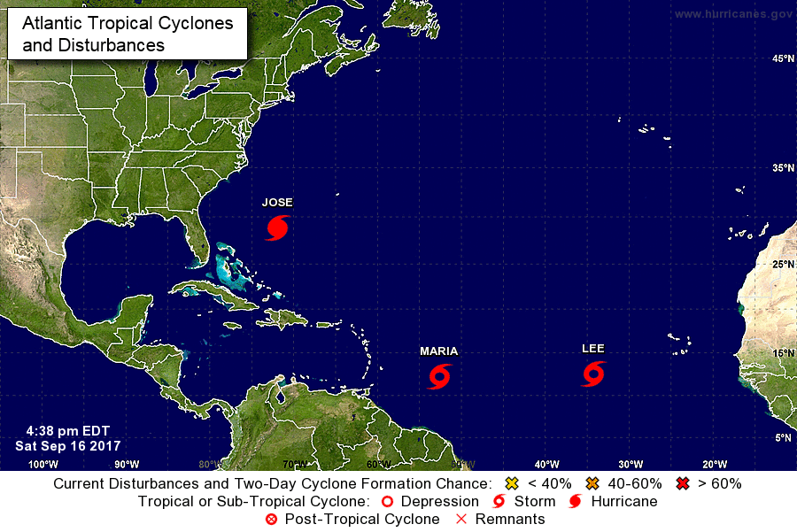
同時北大西洋又再次出現三旋共舞局面...
two_atl_0d0.png


回復

使用道具 舉報

簽到天數: 601 天

[LV.9]以壇為家II

霧峰追風者|2017-9-16 23:33 | 顯示全部樓層
NHC 升格"潛在熱帶氣旋15L",逐漸增強,趨向背風群島。
ZCZC MIATCDAT5 ALL
TTAA00 KNHC DDHHMM

Potential Tropical Cyclone Fifteen Discussion Number   1
NWS National Hurricane Center Miami FL       AL152017
1100 AM AST Sat Sep 16 2017

Satellite images indicate that the area of low pressure located
several hundred miles east of the Lesser Antilles has become better
organized with curved banding features now better established.
Since there is still no indication of a well-defined center and
because tropical storm watches have been issued for portions of
the Leeward Islands, NHC has initiated advisories on this system as
a potential tropical cyclone.  The initial wind speed is estimated
to be 30 kt based on a blend of the Dvorak classifications from TAFB
and SAB.

The initial motion estimate is 280/19, but this is uncertain due to
the lack of a clear center.  A slower west-northwestward motion is
expected during the next several days as a mid-level ridge to the
north of the system weakens but remains nearly stationary.  The NHC
track forecast takes the system across the Leeward Islands in a few
days and then near the Virgin Islands and Puerto Rico by the end of
the forecast period.  It should be noted that confidence in the
track and forward speed of this system is low due to the spread in
the models and the current lack of a well-defined center.

The disturbance is expected to be in environmental conditions
conducive for strengthening during the next several days as the
shear is expected to be 10 kt or less while the cyclone moves over
warm 29 deg C SSTs.  These conditions should allow for at least
steady strengthening, and the models unanimously show that trend.
The NHC intensity forecast is conservative for now, but does show
the system becoming a tropical storm later today and a hurricane by
the time it reaches the Leeward Islands.

KEY MESSAGES:

1. The disturbance is expected to intensify and will likely bring
tropical storm and hurricane conditions as well as flooding
rainfall to portions of the Lesser Antilles early next week. These
conditions could also spread into the Virgin Islands and Puerto Rico
by mid week. Interests in these areas should monitor the progress
of this system and follow any advice given by local officials.

FORECAST POSITIONS AND MAX WINDS

INIT  16/1500Z 12.2N  50.5W   30 KT  35 MPH...POTENTIAL TROP CYCLONE
12H  17/0000Z 12.8N  52.8W   35 KT  40 MPH...TROPICAL STORM
24H  17/1200Z 13.6N  55.1W   40 KT  45 MPH
36H  18/0000Z 14.3N  56.9W   50 KT  60 MPH
48H  18/1200Z 15.0N  58.6W   60 KT  70 MPH
72H  19/1200Z 16.3N  61.3W   75 KT  85 MPH
96H  20/1200Z 17.6N  64.0W   80 KT  90 MPH
120H  21/1200Z 18.7N  67.3W   80 KT  90 MPH

$$
Forecaster Cangialosi

NNNN
145528_5day_cone_no_line_and_wind.png rbtop-animated (11).gif


回復

使用道具 舉報

簽到天數: 2095 天

[LV.Master]伴壇終老

周子堯@FB|2017-9-16 10:27 | 顯示全部樓層
本帖最後由 周子堯@FB 於 2017-9-16 10:33 編輯

NHC展望提升至 80%(High)
1. Showers and thunderstorms associated with a tropical wave located
a little more than 1000 miles east of the Windward Islands are
showing signs of organization.  Environmental conditions are
conducive for additional development, and a tropical cyclone is
likely to form during the next day or so while the system moves
westward or west-northwestward around 20 mph.  Interests in the
Lesser Antilles and northeastern Caribbean should closely monitor
the progress of this system.  Tropical storm or hurricane watches
could be issued for portions of the Lesser Antilles on Saturday.
* Formation chance through 48 hours...high...80 percent.
* Formation chance through 5 days...high...90 percent.

two_atl_2d1.png

rbtop_lalo-animated.gif

回復

使用道具 舉報

簽到天數: 601 天

[LV.9]以壇為家II

霧峰追風者|2017-9-16 06:35 | 顯示全部樓層
NHC 展望提高至70%。
1. Showers and thunderstorms associated with a tropical wave located
about 1100 miles east of the Windward Islands have become better
organized since yesterday.  Environmental conditions are conducive
for development, and a tropical cyclone is expected to form over
the weekend.  Tropical storm or hurricane watches could be issued
for portions of the Lesser Antilles on Saturday, and interests
in those islands should closely monitor the progress of this system.
* Formation chance through 48 hours...high...70 percent.
* Formation chance through 5 days...high...90 percent.
two_atl_2d1 (2).png rbtop-animated (8).gif


回復

使用道具 舉報

簽到天數: 601 天

[LV.9]以壇為家II

霧峰追風者|2017-9-15 16:37 | 顯示全部樓層
NHC展望提高至40%。
1. A tropical wave located about 1200 miles east-southeast of the
Lesser Antilles continues to produce disorganized showers and
thunderstorms.  Environmental conditions are expected to be
conducive for gradual development, and a tropical depression is
likely to form early next week.  Interests in the Lesser Antilles
should closely monitor the progress of this system while it moves
westward to west-northwestward at about 15 mph.
* Formation chance through 48 hours...medium...40 percent.
* Formation chance through 5 days...high...80 percent.
two_atl_2d1 (1).png


回復

使用道具 舉報

123456
快速回覆
您需要登錄後才可以回帖 登錄 | 立即加入

本版積分規則

本平台僅供學術討論之用,預報應以氣象局為準

威普網站虛擬主機贊助公司

臺灣第一個天氣類型社群平台 即時天氣資訊、精準颱風動態

線上客服
FB傳送訊息
廣告行銷
精準行銷 物超所值
官方粉專
發佈 快速回復 返回頂部 返回列表