開啟輔助訪問
 找回密碼
 立即加入

21S.Veronica 登陸前轉向 沿西澳西北部近海西行

簽到天數: 1650 天

[LV.Master]伴壇終老

老農民版夜神月|2019-3-21 10:04 | 顯示全部樓層
本帖最後由 老農民版夜神月 於 2019-3-21 12:20 編輯

BoM2100Z定強亦達100KT,並預測六小時內增強至澳式C5

IDW27600
TROPICAL CYCLONE TECHNICAL BULLETIN: AUSTRALIA - WESTERN REGION
Issued by PERTH TROPICAL CYCLONE WARNING CENTRE
at: 0124 UTC 21/03/2019
Name: Severe Tropical Cyclone Veronica
Identifier: 19U
Data At: 0000 UTC
Latitude: 16.4S
Longitude: 117.7E
Location Accuracy: within 15 nm [30 km]
Movement Towards: south [169 deg]
Speed of Movement: 5 knots [9 km/h]
Maximum 10-Minute Wind: 100 knots [185 km/h]
Maximum 3-Second Wind Gust: 140 knots [260 km/h]
Central Pressure: 944 hPa
Radius of 34-knot winds NE quadrant: 100 nm [185 km]
Radius of 34-knot winds SE quadrant: 100 nm [185 km]
Radius of 34-knot winds SW quadrant: 100 nm [185 km]
Radius of 34-knot winds NW quadrant: 100 nm [185 km]
Radius of 48-knot winds NE quadrant: 50 nm [95 km]
Radius of 48-knot winds SE quadrant: 50 nm [95 km]
Radius of 48-knot winds SW quadrant: 50 nm [95 km]
Radius of 48-knot winds NW quadrant: 50 nm [95 km]
Radius of 64-knot winds: 30 nm [55 km]
Radius of Maximum Winds: 15 nm [30 km]
Dvorak Intensity Code: T6.0/6.0/D3.0/24HRS STT:D0.5/06HRS
Pressure of outermost isobar: 1004 hPa
Radius of outermost closed isobar: 180 nm [335 km]
FORECAST DATA
Date/Time    : Location    : Loc. Accuracy: Max Wind   : Central Pressure
[UTC]        : degrees     :      nm  [km]: knots[km/h]: hPa
+06:  21/0600: 16.8S 117.5E:     025 [050]:  110  [205]:  933
+12:  21/1200: 17.2S 117.3E:     040 [070]:  110  [205]:  933
+18:  21/1800: 17.4S 117.1E:     050 [095]:  110  [205]:  932
+24:  22/0000: 17.6S 116.9E:     065 [120]:  110  [205]:  932
+36:  22/1200: 18.2S 116.7E:     085 [155]:  110  [205]:  931
+48:  23/0000: 18.8S 116.9E:     105 [190]:  110  [205]:  931
+60:  23/1200: 19.7S 117.3E:     120 [225]:  110  [205]:  931
+72:  24/0000: 20.4S 117.8E:     140 [265]:  100  [185]:  940
+96:  25/0000: 21.0S 118.0E:     185 [345]:  055  [100]:  978
+120: 26/0000: 21.7S 117.0E:     275 [505]:  030  [055]:  998
REMARKS:
Severe TC Veronica has rapidly intensified overnight developing a well defined
eye overnight.

Intensity estimate is 100 kn [category 4]. Dvorak analysis: FT/CI=6.0. This
breaks the intensity constraint by increasing more than 2.5 in 24h but still
short of recent DT of 6.5-7.0 based on eye pattern; Adjusted MET is 5.0 on a
strong D+ trend. CIMSS/NESDIS ADT CI has risen rapidly to [raw 5.9] and SATCON
is lagging at 85kn [10min] but is likely to increase rapidly soon.

The environmental conditions are favourable as is evident by the rapid
intensification over the last 24 hours. Strong poleward and equatorward upper
level outflow, low wind shear, abundant amount of moisture and SSTS of over 30C.


The forecast intensity may fluctuate [cat4-5] in the next 48h owing to inner
core variations. Prior to landfall upper level winds become unfavourable so some
weakening is forecast but this depends on the track and how resilient the
circulation is to the change in upper winds.   

The motion is currently to the south although a resumption to a more south
southwest or southwest track is indicated by all the model guidance within 12
hours. An upper trough may assist in south to southeastward motion towards the
Pilbara coast on Saturday. The cyclone is expected to be moving slowly as it
approaches the coast making a prediction of landfall timing difficult - as early
as overnight Saturday-Sunday or as late as Monday. Some guidance indicates a
subsequent track to the west near the coast. This could result in the cyclone
remaining near or just offshore the west Pilbara coast for a couple days early
next week.

Tides will be close to the highest astronomical tide over the weekend
exacerbating the risk of a significant storm tide impact, but will depend upon
the landfall timing. The slow motion also means that rainfall totals will be
higher than for normal cyclone rainfall levels and totals in excess of 500mm are
possible.
Copyright Commonwealth of Australia
==
The next bulletin for this system will be issued by: 21/0730 UTC by Perth TCWC.
未命名20190321.png 20190321.0340.himawari-8.ircolor.21S.VERONICA.125kts.930mb.16.4S.117.7E.100pc.jpg
回復

使用道具 舉報

簽到天數: 601 天

[LV.9]以壇為家II

霧峰追風者|2019-3-21 10:01 | 顯示全部樓層
BoM 00Z強度同樣升澳式C4,巔峰上望澳式C5。
IDW27600
TROPICAL CYCLONE TECHNICAL BULLETIN: AUSTRALIA - WESTERN REGION
Issued by PERTH TROPICAL CYCLONE WARNING CENTRE
at: 0124 UTC 21/03/2019
Name: Severe Tropical Cyclone Veronica
Identifier: 19U
Data At: 0000 UTC
Latitude: 16.4S
Longitude: 117.7E
Location Accuracy: within 15 nm [30 km]
Movement Towards: south [169 deg]
Speed of Movement: 5 knots [9 km/h]
Maximum 10-Minute Wind: 100 knots [185 km/h]
Maximum 3-Second Wind Gust: 140 knots [260 km/h]
Central Pressure: 944 hPa
Radius of 34-knot winds NE quadrant: 100 nm [185 km]
Radius of 34-knot winds SE quadrant: 100 nm [185 km]
Radius of 34-knot winds SW quadrant: 100 nm [185 km]
Radius of 34-knot winds NW quadrant: 100 nm [185 km]
Radius of 48-knot winds NE quadrant: 50 nm [95 km]
Radius of 48-knot winds SE quadrant: 50 nm [95 km]
Radius of 48-knot winds SW quadrant: 50 nm [95 km]
Radius of 48-knot winds NW quadrant: 50 nm [95 km]
Radius of 64-knot winds: 30 nm [55 km]
Radius of Maximum Winds: 15 nm [30 km]
Dvorak Intensity Code: T6.0/6.0/D3.0/24HRS STT:D0.5/06HRS
Pressure of outermost isobar: 1004 hPa
Radius of outermost closed isobar: 180 nm [335 km]
FORECAST DATA
Date/Time    : Location    : Loc. Accuracy: Max Wind   : Central Pressure
[UTC]        : degrees     :      nm  [km]: knots[km/h]: hPa
+06:  21/0600: 16.8S 117.5E:     025 [050]:  110  [205]:  933
+12:  21/1200: 17.2S 117.3E:     040 [070]:  110  [205]:  933
+18:  21/1800: 17.4S 117.1E:     050 [095]:  110  [205]:  932
+24:  22/0000: 17.6S 116.9E:     065 [120]:  110  [205]:  932
+36:  22/1200: 18.2S 116.7E:     085 [155]:  110  [205]:  931
+48:  23/0000: 18.8S 116.9E:     105 [190]:  110  [205]:  931
+60:  23/1200: 19.7S 117.3E:     120 [225]:  110  [205]:  931
+72:  24/0000: 20.4S 117.8E:     140 [265]:  100  [185]:  940
+96:  25/0000: 21.0S 118.0E:     185 [345]:  055  [100]:  978
+120: 26/0000: 21.7S 117.0E:     275 [505]:  030  [055]:  998
REMARKS:
Severe TC Veronica has rapidly intensified overnight developing a well defined
eye overnight.

Intensity estimate is 100 kn [category 4]. Dvorak analysis: FT/CI=6.0. This
breaks the intensity constraint by increasing more than 2.5 in 24h but still
short of recent DT of 6.5-7.0 based on eye pattern; Adjusted MET is 5.0 on a
strong D+ trend. CIMSS/NESDIS ADT CI has risen rapidly to [raw 5.9] and SATCON
is lagging at 85kn [10min] but is likely to increase rapidly soon.

The environmental conditions are favourable as is evident by the rapid
intensification over the last 24 hours. Strong poleward and equatorward upper
level outflow, low wind shear, abundant amount of moisture and SSTS of over 30C.


The forecast intensity may fluctuate [cat4-5] in the next 48h owing to inner
core variations. Prior to landfall upper level winds become unfavourable so some
weakening is forecast but this depends on the track and how resilient the
circulation is to the change in upper winds.  

The motion is currently to the south although a resumption to a more south
southwest or southwest track is indicated by all the model guidance within 12
hours. An upper trough may assist in south to southeastward motion towards the
Pilbara coast on Saturday. The cyclone is expected to be moving slowly as it
approaches the coast making a prediction of landfall timing difficult - as early
as overnight Saturday-Sunday or as late as Monday. Some guidance indicates a
subsequent track to the west near the coast. This could result in the cyclone
remaining near or just offshore the west Pilbara coast for a couple days early
next week.

Tides will be close to the highest astronomical tide over the weekend
exacerbating the risk of a significant storm tide impact, but will depend upon
the landfall timing. The slow motion also means that rainfall totals will be
higher than for normal cyclone rainfall levels and totals in excess of 500mm are
possible.


Copyright Commonwealth of Australia
==
The next bulletin for this system will be issued by: 21/0730 UTC by Perth TCWC.

IDW60280.png Screenshot_2019-03-21-09-57-56_com.android.chrome_1553133491682.jpg bd_lalo-animated (2).gif

回復

使用道具 舉報

簽到天數: 601 天

[LV.9]以壇為家II

霧峰追風者|2019-3-21 09:49 | 顯示全部樓層
JTWC 00Z強度升四級颶風125kts,分析到T6.5。
SH, 21, 2019032100,   , BEST,   0, 164S, 1177E, 125,  929, TY,  34, NEQ,  160,  170,  150,  135, 1005,  190,  15,   0,   0,    ,   0,    ,   0,   0,   VERONICA,  ,
SH, 21, 2019032100,   , BEST,   0, 164S, 1177E, 125,  929, TY,  50, NEQ,   70,   80,   70,   60, 1005,  190,  15,   0,   0,    ,   0,    ,   0,   0,   VERONICA,  ,
SH, 21, 2019032100,   , BEST,   0, 164S, 1177E, 125,  929, TY,  64, NEQ,   40,   45,   35,   30, 1005,  190,  15,   0,   0,    ,   0,    ,   0,   0,   VERONICA,  ,
TXXS27 KNES 210016
TCSSIO
A.  21S (VERONICA)
B.  20/2330Z
C.  16.3S
D.  117.7E
E.  ONE/HIMAWARI-8
F.  T6.5/6.5/D3.0/24HRS
G.  IR/EIR
H.  REMARKS...THIS INTENSITY ESTIMATE WAS DERIVED USING 4 KM IR DATA. OW
EYE SURROUNDED BY CMG RING AND EMBEDDED IN W YIELDS E#=6.0 AND +0.5 FOR
EYE ADJUSTMENT. DT=6.5 MET=5.0 PT=5.5. 6-HR AVERAGING OF DT FOR RAPID
INTENSIFICATION ALSO YIELDS DT=6.5 THAT OVERCOMES CONSTRAINTS LIMITING
MAX CHANGES IN FT OVER 18 HRS TO 2.0 AND OVER 24 HRS TO 2.5. FT OF 6.5
IS BASED ON RAPID INTENSIFICATION.
I.  ADDL POSITIONS
    NIL
...VELASCO

TPXS10 PGTW 210019
A. TROPICAL CYCLONE 21S (VERONICA)
B. 20/2350Z
C. 16.37S
D. 117.70E
E. ONE/HMWRI8
F. T6.5/6.5/D3.5/24HRS  STT: S0.0/03HRS
G. IR/EIR/VIS/MSI
H. REMARKS: 07A/PBO IRREG EYE/ANMTN. OW EYE SURROUNDED BY W
YIELDS AN E# OF 6.0. ADDED 0.5 EYE ADJUSTMENT FOR CMG, TO YIELD
A DT OF 6.5. MET YIELDS A 4.5 ND PT YIELDS A 5.5. DBO DT. BROKE
CONTRAINTS OF +1.5 TNO CHANGE OVER 24 HRS DUE TO SYSTEMS RAPID
INTENSIFICATION.
I. ADDITIONAL POSITIONS:
   20/1852Z  15.92S  117.67E  SSMI
   BERMEA
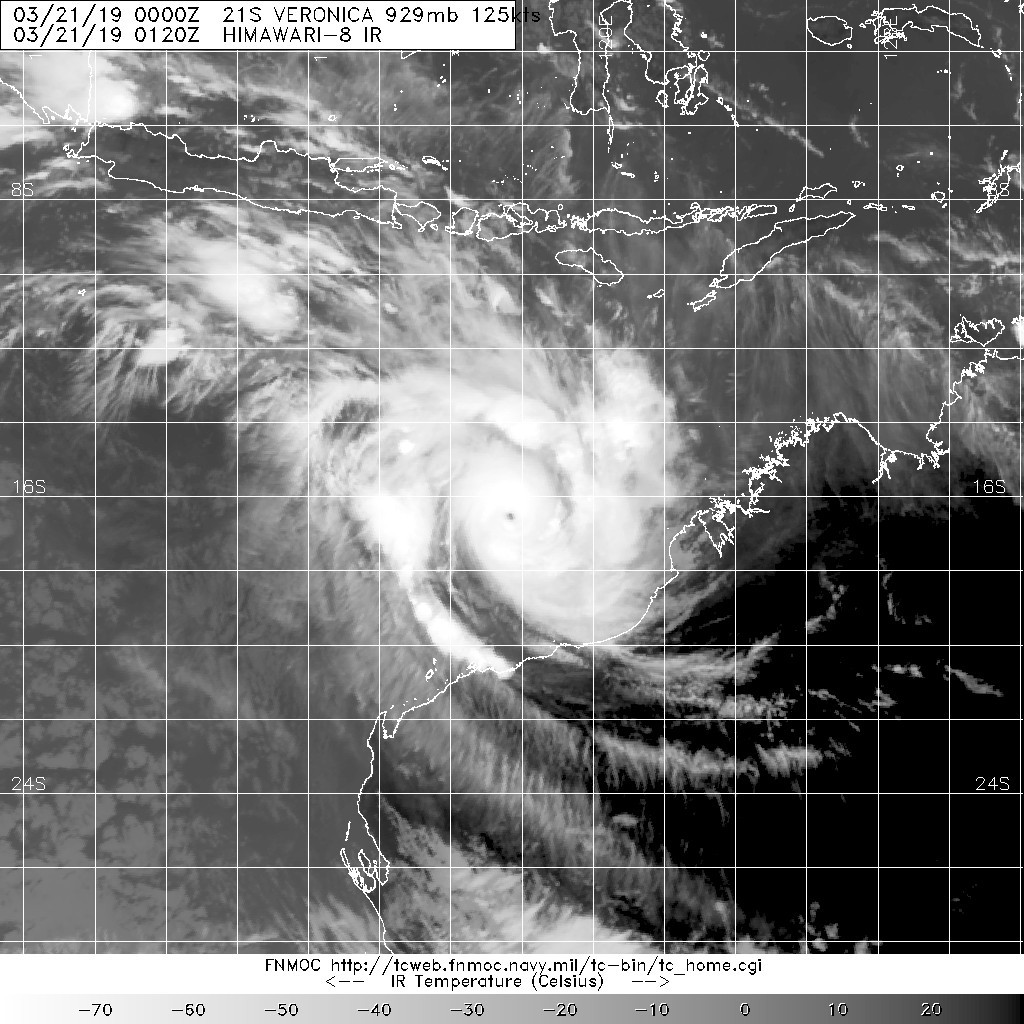
20190321.0120.himawari-8.ir.21S.VERONICA.125kts.929mb.16.4S.117.7E.100pc.jpg

回復

使用道具 舉報

簽到天數: 601 天

[LV.9]以壇為家II

霧峰追風者|2019-3-21 08:22 | 顯示全部樓層
JTWC 18Z巔峰上望五級颶風。
sh212019.20190320212318.gif 20190320.2234.f17.ir.olsircomp.21S.VERONICA.x.jpg

回復

使用道具 舉報

簽到天數: 868 天

[LV.10]以壇為家III

jrchang5|2019-3-21 04:35 | 顯示全部樓層
BoM判定20/18Z升格為澳式C4。巔峰強度雖上看澳式C5,但不致以巔峰之姿侵襲西澳北部。
IDW27600
TROPICAL CYCLONE TECHNICAL BULLETIN: AUSTRALIA - WESTERN REGION
Issued by PERTH TROPICAL CYCLONE WARNING CENTRE
at: 1907 UTC 20/03/2019
Name: Severe Tropical Cyclone Veronica
Identifier: 19U
Data At: 1800 UTC
Latitude: 15.9S
Longitude: 117.6E
Location Accuracy: within 15 nm [30 km]
Movement Towards: west southwest [255 deg]
Speed of Movement: 4 knots [7 km/h]
Maximum 10-Minute Wind: 90 knots [165 km/h]
Maximum 3-Second Wind Gust: 125 knots [230 km/h]
Central Pressure: 954 hPa
Radius of 34-knot winds NE quadrant: 90 nm [165 km]
Radius of 34-knot winds SE quadrant: 90 nm [165 km]
Radius of 34-knot winds SW quadrant: 90 nm [165 km]
Radius of 34-knot winds NW quadrant: 90 nm [165 km]
Radius of 48-knot winds NE quadrant: 50 nm [95 km]
Radius of 48-knot winds SE quadrant: 50 nm [95 km]
Radius of 48-knot winds SW quadrant: 50 nm [95 km]
Radius of 48-knot winds NW quadrant: 50 nm [95 km]
Radius of 64-knot winds: 30 nm [55 km]
Radius of Maximum Winds: 15 nm [30 km]
Dvorak Intensity Code: T5.5/5.5/D2.5/24HRS STT:D1.0/06HRS
Pressure of outermost isobar: 1004 hPa
Radius of outermost closed isobar: 140 nm [260 km]
FORECAST DATA
Date/Time    : Location    : Loc. Accuracy: Max Wind   : Central Pressure
[UTC]        : degrees     :      nm  [km]: knots[km/h]: hPa
+06:  21/0000: 16.1S 117.3E:     025 [050]:  095  [175]:  949
+12:  21/0600: 16.3S 117.0E:     040 [070]:  100  [185]:  943
+18:  21/1200: 16.5S 116.8E:     050 [095]:  105  [195]:  937
+24:  21/1800: 16.6S 116.6E:     065 [120]:  105  [195]:  937
+36:  22/0600: 17.0S 116.2E:     085 [155]:  110  [205]:  932
+48:  22/1800: 17.4S 116.2E:     105 [190]:  110  [205]:  931
+60:  23/0600: 18.1S 116.4E:     125 [230]:  110  [205]:  937
+72:  23/1800: 19.0S 116.8E:     140 [265]:  105  [195]:  942
+96:  24/1800: 20.1S 117.0E:     185 [345]:  090  [165]:  949
+120: 25/1800: 21.5S 116.8E:     275 [505]:  050  [095]:  984
REMARKS:
Severe TC Veronica has rapidly intensified and was located using EIR imagery.
Confidence in the position is reasonably high as an eye is visible in satellite
imagery.

Dvorak analysis is based on an eye pattern, giving a DT of 6.0 [averaged over 3
hours]. MET is 4.5 based on a trend of D+ with a PAT adjustment yielding 5.
FT/CI is set at 5.5. CIMSS ADT CI was 4.9 [raw 6.8]. NESDIS ADT CI was 3.9.
SATCON at 1055UTC was 83 knots [1min]. Final intensity estimate is set at 90
knots [10-min].

The environmental conditions are favourable as is evident by the rapid
intensification over the last 12 hours. A shear ridge lies over the system and
there is an abundant amount of moisture. CIMSS shear at 13 UTC was E'ly around 7
knots. SSTs are very favourable, around 30C. There is strong upper divergence
over the system, with both poleward and equatorward outflow channels present in
satellite imagery and indicated in the upper wind analysis from CIMSS.

The system motion is currently to the west southwest due to a weak upper ridge
over Australia. In the longer term an upper trough may assist in south to
southeastward motion towards the Pilbara coast later in the week or over the
weekend. The system is expected to be moving slowly southwards as it approaches
the coast where the environment becomes less favourable with increasing wind
shear. There is some model guidance suggesting that the system could slow
further before reaching the coast on Sunday or Monday and then possibly begin
moving to the west. This could result in the cyclone remaining near or just
offshore the west Pilbara coast for a couple days early next week.

There is a significant risk of a category 4 coastal impact in the Pilbara region
of Western Australia over the weekend or early next week.

Copyright Commonwealth of Australia
==
The next bulletin for this system will be issued by: 21/0130 UTC by Perth TCWC.
IDW60280.png 20190320.1950.himawari-8.ir.21S.VERONICA.110kts.948mb.15.9S.117.6E.100pc.jpg rgb_lalo-animated (1).gif rbtop_lalo-animated.gif


回復

使用道具 舉報

簽到天數: 1650 天

[LV.Master]伴壇終老

老農民版夜神月|2019-3-21 03:23 | 顯示全部樓層
快速爆發性增強,T值數小時內已飆升至6.0
TPXS10 PGTW 201836

A. TROPICAL CYCLONE 21S (VERONICA)

B. 20/1800Z

C. 15.89S

D. 117.67E

E. ONE/HMWRI8

F. T6.0/6.0/D3.5/24HRS STT: D1.0/03HRS

G. IR/EIR

H. REMARKS: 05A/PBO IRREG EYE/ANMTN. MG EYE SURROUNDED BY W
YIELDS AN E# AND DT (NO EYE ADJUSTMENT) OF 6.0. MET YIELDS A
4.0 AND PT YIELDS A 5.0. DBO DT. BROKE CONSTRAINTS OF +2.5 TNO
OVER 24HRS,

I. ADDITIONAL POSITIONS: NONE


BERMEA

20190320.1830.himawari-8.ircolor.21S.VERONICA.60kts.987mb.15.9S.117.8E.100pc.jpg 20190320.1830.himawari-8.irbd.21S.VERONICA.60kts.987mb.15.9S.117.8E.100pc.jpg


21S VERONICA 190320 1800 15.9S 117.6E SHEM 110 948
JTWC也迅速將定強幾乎向上翻了一倍,已調整至C3上限


環境十分優良,系統本身也夠爭氣,BoM上望澳式C5
ff947d1ed21b0ef468d9545ad3c451da81cb3e53.jpg db5c19d8bc3eb13568bf69bfa81ea8d3fd1f4414.jpg
a6494134970a304e465a7efedfc8a786c9175c14.jpg ce9cd1c8a786c917177b8c3dc73d70cf3bc75714.jpg


回復

使用道具 舉報

簽到天數: 241 天

[LV.8]以壇為家I

krichard2011|2019-3-20 23:52 | 顯示全部樓層
這隻看來要領先一步了
目前看起來即將開啟針眼
20190320.1510.hm8.x.ir1km.21SVERONICA.60kts-987mb-159S-1178E.100pc.jpg

回復

使用道具 舉報

簽到天數: 601 天

[LV.9]以壇為家II

霧峰追風者|2019-3-20 21:51 | 顯示全部樓層
本帖最後由 霧峰追風者 於 2019-3-20 21:52 編輯

BoM 強度升澳式C3,對流猛爆增強中,顛峰上望100kt。
IDW27600
TROPICAL CYCLONE TECHNICAL BULLETIN: AUSTRALIA - WESTERN REGION
Issued by PERTH TROPICAL CYCLONE WARNING CENTRE
at: 1308 UTC 20/03/2019
Name: Severe Tropical Cyclone Veronica
Identifier: 19U
Data At: 1200 UTC
Latitude: 15.8S
Longitude: 118.0E
Location Accuracy: within 25 nm [45 km]
Movement Towards: west southwest [240 deg]
Speed of Movement: 5 knots [9 km/h]
Maximum 10-Minute Wind: 65 knots [120 km/h]
Maximum 3-Second Wind Gust: 90 knots [165 km/h]
Central Pressure: 976 hPa
Radius of 34-knot winds NE quadrant: 90 nm [165 km]
Radius of 34-knot winds SE quadrant: 90 nm [165 km]
Radius of 34-knot winds SW quadrant: 90 nm [165 km]
Radius of 34-knot winds NW quadrant: 90 nm [165 km]
Radius of 48-knot winds NE quadrant: 50 nm [95 km]
Radius of 48-knot winds SE quadrant: 50 nm [95 km]
Radius of 48-knot winds SW quadrant: 50 nm [95 km]
Radius of 48-knot winds NW quadrant: 50 nm [95 km]
Radius of 64-knot winds: 30 nm [55 km]
Radius of Maximum Winds: 15 nm [30 km]
Dvorak Intensity Code: T4.5/4.5/D2.0/24HRS STT:D1.0/06HRS
Pressure of outermost isobar: 1004 hPa
Radius of outermost closed isobar: 150 nm [280 km]
FORECAST DATA
Date/Time    : Location    : Loc. Accuracy: Max Wind   : Central Pressure
[UTC]        : degrees     :      nm  [km]: knots[km/h]: hPa
+06:  20/1800: 16.1S 117.6E:     035 [070]:  070  [130]:  972
+12:  21/0000: 16.2S 117.2E:     050 [090]:  075  [140]:  967
+18:  21/0600: 16.3S 116.9E:     060 [115]:  080  [150]:  963
+24:  21/1200: 16.4S 116.7E:     075 [135]:  085  [155]:  958
+36:  22/0000: 16.8S 116.2E:     095 [175]:  095  [175]:  948
+48:  22/1200: 17.2S 116.1E:     115 [210]:  100  [185]:  942
+60:  23/0000: 17.8S 116.2E:     130 [245]:  100  [185]:  943
+72:  23/1200: 18.6S 116.5E:     150 [280]:  095  [175]:  947
+96:  24/1200: 20.8S 116.6E:     195 [365]:  090  [165]:  950
+120: 25/1200: 22.8S 116.1E:     285 [525]:  040  [075]:  990
REMARKS:
Severe TC Veronica has rapidly intensified and was located using EIR and
Microwave imagery. Confidence in the position is reasonably high as an eye has
become visible in satellite imagery and recent microwave passes.

GMI microwave image at 1011 UTC showed deep convection wrapping almost
completely around the centre.


Dvorak analysis is based on an eye pattern, giving a DT of 5.0 [averaged over 3
hours]. MET is
4.0 based on a trend of D+ with a PAT adjustment yielding 4.5. FT/CI is set at
4.5. CIMSS ADT CI was 4.3. NESDIS ADT CI was 3.8. There have not been any recent
SATCON estimates. Final intensity estimate is set at 65 knots [10-min].

The environmental conditions are favourable for further development, with a
shear ridge lying over the system and abundant moisture. CIMSS shear at 09 UTC
was E'ly around 10 knots. SSTs are very favourable, around 30C. There is strong
upper divergence over the system, with both poleward and equatorward outflow
channels present in satellite imagery and indicated in the upper wind analysis
from CIMSS. Consistent with the favourable environment, guidance is indicating
the potential for rapid development.

The system motion is currently to the west southwest due to a weak upper ridge
over Australia. In the longer term an upper trough may assist in south to
southeastward motion towards the Pilbara coast later in the week or over the
weekend. The system is expected to be moving slowly southwards as it approaches
the coast.

There is a significant risk of a category 4 coastal impact in the Pilbara region
of Western Australia over the weekend or early next week.

Copyright Commonwealth of Australia
==
The next bulletin for this system will be issued by: 20/1930 UTC by Perth TCWC.
IDW60280.png rgb_lalo-animated.gif bd_lalo-animated.gif
回復

使用道具 舉報

快速回覆
您需要登錄後才可以回帖 登錄 | 立即加入

本版積分規則

本平台僅供學術討論之用,預報應以氣象局為準

威普網站虛擬主機贊助公司

臺灣第一個天氣類型社群平台 即時天氣資訊、精準颱風動態

線上客服
FB傳送訊息
廣告行銷
精準行銷 物超所值
官方粉專
發佈 快速回復 返回頂部 返回列表