開啟輔助訪問
 找回密碼
 立即加入

13L.Lorenzo 二次巔峰短暫上C5 大西洋中部北上轉化

簽到天數: 1650 天

[LV.Master]伴壇終老

老農民版夜神月|2019-9-24 00:23 | 顯示全部樓層
NHC23/15Z報升格TS,命名Lorenzo
000
WTNT43 KNHC 231446
TCDAT3

Tropical Storm Lorenzo Discussion Number   3
NWS National Hurricane Center Miami FL       AL132019
1100 AM AST Mon Sep 23 2019

Yet another tropical storm has formed over the Atlantic, this one
over the far eastern portion of the basin. The system has been
designated as Tropical Storm Lorenzo based on satellite intensity
estimates from TAFB, SAB, and UW-CIMSS, all of which support
tropical-storm strength. The initial intensity is set at 35 kt, but
its possible this is somewhat conservative since the TAFB
classification was a little higher.

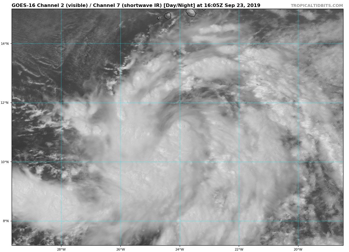
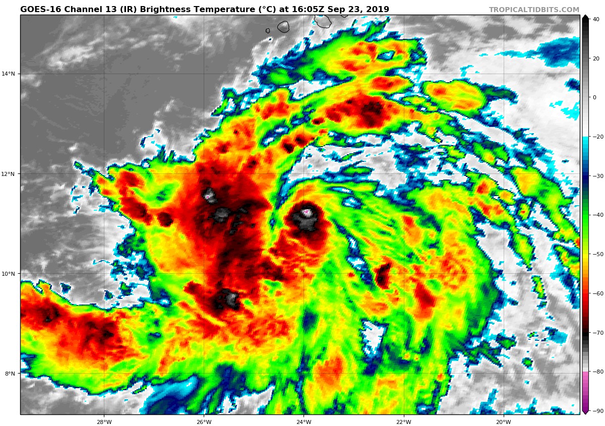
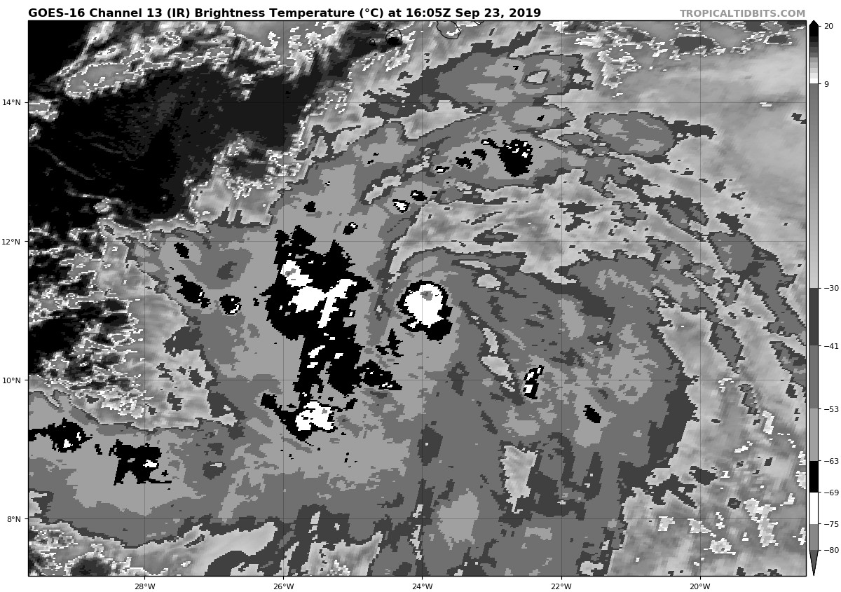
Recent GMI microwave imagery and ASCAT-C data showed that the
low-level center of Lorenzo is on the north side of most of its deep
convection. While this disorganized structure may limit how quickly
Lorenzo can strengthen in the short-term, the tropical storm is
located within a generally favorable environment for
intensification. All of the intensity guidance shows Lorenzo
becoming a hurricane, but the timing varies from model to model. The
official forecast follows the HFIP Corrected Consensus, and shows
Lorenzo reaching hurricane status within 48 h. Continued
strengthening is forecast thereafter. No noteworthy changes were
made to the NHC intensity forecast.

The ASCAT and microwave data were very helpful in determining the
location of Lorenzo's center and its forward speed. The cyclone
has accelerated and the initial motion estimate is now 275/15 kt.
Very little adjustment was made to the NHC track forecast. Lorenzo
is still forecast to be steered generally westward to
west-northwestward to the south of a deep-layer ridge centered over
the eastern Atlantic. The cyclone will pass well south and southwest
of the Cabo Verde Islands through tonight. A turn toward the
northwest is forecast in about 4 days as Lorenzo reaches a break in
the ridge. Just like the intensity forecast, the track forecast is
based heavily on HCCA.

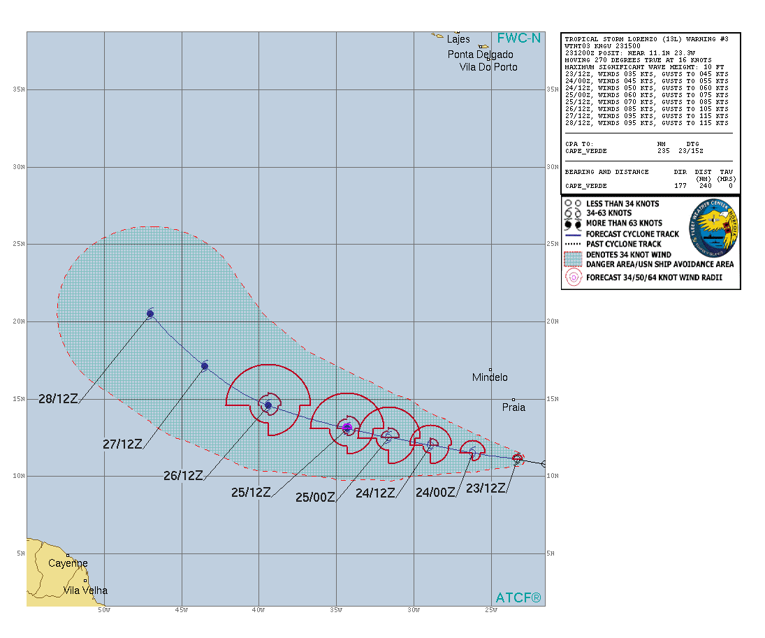
FORECAST POSITIONS AND MAX WINDS

INIT  23/1500Z 11.1N  24.1W   35 KT  40 MPH
12H  24/0000Z 11.5N  26.2W   45 KT  50 MPH
24H  24/1200Z 12.0N  28.9W   50 KT  60 MPH
36H  25/0000Z 12.5N  31.6W   60 KT  70 MPH
48H  25/1200Z 13.1N  34.3W   70 KT  80 MPH
72H  26/1200Z 14.6N  39.4W   85 KT 100 MPH
96H  27/1200Z 17.1N  43.5W   95 KT 110 MPH
120H  28/1200Z 20.5N  47.0W   95 KT 110 MPH

$$
Forecaster Zelinsky
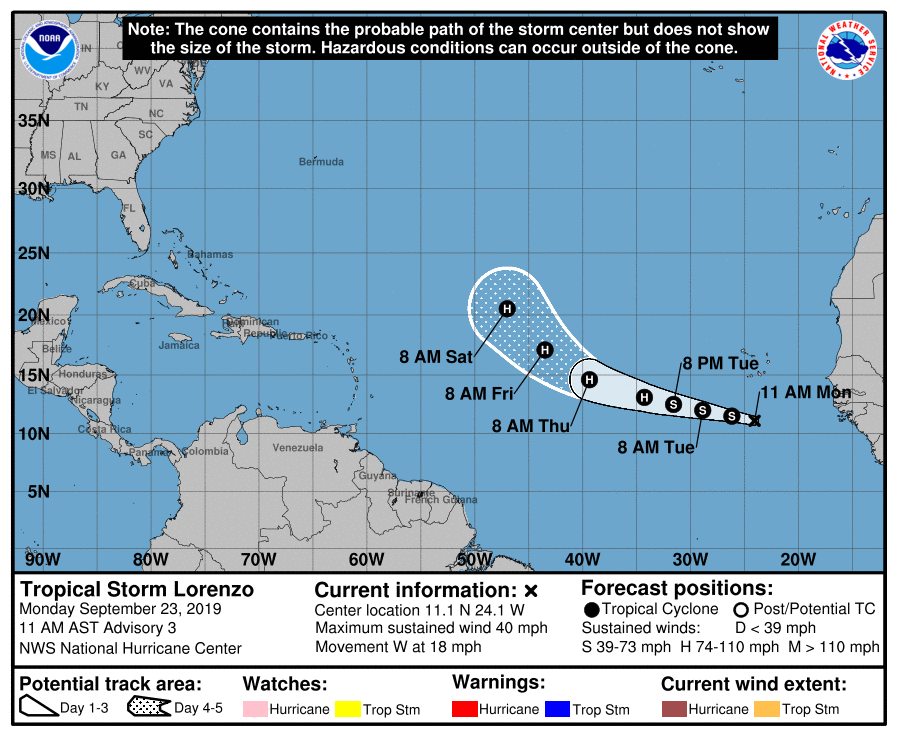
144724_5day_cone_no_line_and_wind.png al132019.gif
goes16_vis-swir_13L_201909231605.jpg goes16_ir_13L_201909231605.jpg
goes16_ir-dvorak_13L_201909231605.jpg

回復

使用道具 舉報

簽到天數: 3279 天

[LV.Master]伴壇終老

t02436|2019-9-23 10:59 | 顯示全部樓層
NHC升格13L,上望95節不封頂。
424
WTNT43 KNHC 230244
TCDAT3

Tropical Depression Thirteen Discussion Number   1
NWS National Hurricane Center Miami FL       AL132019
1100 PM AST Sun Sep 22 2019

Satellite imagery and partial scatterometer overpasses indicate
that the tropical wave in the eastern tropical Atlantic has
developed enough circulation and organized convection to be
designated a tropical depression.  The convection is currently
organized into a large band over the western semicircle, with an
additional smaller band to the southeast.  The initial intensity is
set at 30 kt in best agreement with a satellite intensity estimate
from TAFB.

The initial motion is 270/14.  A strong deep-layer ridge to the
north of the depression should steer it generally westward to
west-northwestward for the next 3-4 days, with the center passing
well to the south and southwest of the Cabo Verde Islands.  Near
the end of the forecast period, the cyclone is expected to turn
northwestward as it approaches a weakness in the ridge.  The track
guidance is tightly clustered, and the forecast track is in best
agreement with the HCCA corrected consensus model.

The cyclone is forecast to be in a light to moderate easterly shear
environment over warm sea surface temperatures for the next 3-4
days, and there are no obvious negative factors to prevent
strengthening.  The intensity forecast thus calls for steady
intensification through 96 h, with the intensity forecast lying near
the upper edge of the guidance from 48-96 h.  Some southwesterly
shear may develop near 120 h, so the forecast show little change in
strength from 96-120 h.


FORECAST POSITIONS AND MAX WINDS

INIT  23/0300Z 10.8N  20.9W   30 KT  35 MPH
12H  23/1200Z 10.8N  23.0W   35 KT  40 MPH
24H  24/0000Z 11.1N  25.7W   45 KT  50 MPH
36H  24/1200Z 11.8N  28.3W   55 KT  65 MPH
48H  25/0000Z 12.6N  31.0W   65 KT  75 MPH
72H  26/0000Z 13.8N  36.7W   80 KT  90 MPH
96H  27/0000Z 15.5N  41.5W   95 KT 110 MPH
120H  28/0000Z 19.0N  45.5W   95 KT 110 MPH

$$
Forecaster Beven

024544_5day_cone_with_line.png

20190923.0230.goes-16.ircolor.13L.THIRTEEN.30kts.1007mb.10.8N.20.2W.100pc.jpg
回復

使用道具 舉報

簽到天數: 1650 天

[LV.Master]伴壇終老

老農民版夜神月|2019-9-23 07:37 | 顯示全部樓層
NHC展望已提升至90%/90%
1. Satellite imagery indicates that a broad area of low pressure has
formed in association with a strong tropical wave over the far
eastern Atlantic. The associated thunderstorm activity continues
to show signs of organization, and a tropical depression or
tropical storm is expected to form later today or tonight while
the system moves generally westward over the eastern tropical
Atlantic at 15 to 20 mph. Interests in the Cabo Verde Islands should
monitor the progress of this disturbance. Regardless of development,
this system is likely to bring locally heavy rainfall and gusty
winds to portions of the southern Cabo Verde Islands during the
next day or two.
* Formation chance through 48 hours...high...90 percent.
* Formation chance through 5 days...high...90 percent.
two_atl_2d10922.png two_atl_5d10922.png
goes16_ir_90L_201909222315.jpg


回復

使用道具 舉報

簽到天數: 1650 天

[LV.Master]伴壇終老

老農民版夜神月|2019-9-23 00:05 | 顯示全部樓層
FWC-N發布TCFA
SUBJ/TROPICAL CYCLONE FORMATION ALERT//
RMKS/
1. FORMATION OF A SIGNIFICANT TROPICAL CYCLONE IS POSSIBLE WITHIN
100 NM ON EITHER SIDE OF A LINE FROM 10.5N 16.5W TO 11.4N 24.0W
WITHIN THE NEXT 24 HOURS. AVAILABLE DATA DOES NOT JUSTIFY
ISSUANCE OF NUMBERED TROPICAL CYCLONE WARNINGS AT THIS TIME.
WINDS IN THE AREA ARE ESTIMATED TO BE 20 TO 25 KNOTS. METSAT
IMAGERY AT 220600Z INDICATES THAT A CIRCULATION CENTER IS LOCATED
NEAR 10.5N 16.5W. THE SYSTEM IS MOVING WEST-NORTHWESTWARD AT 15
TO 20 KNOTS.
2. REMARKS:
A TROPICAL WAVE LOCATED OFF THE COAST OF WEST AFRICA IS EXPECTED
TO MERGE OVER THE EXTREME EASTERN ATLANTIC SUNDAY. ENVIRONMENTAL
CONDITIONS ARE EXPECTED TO BE CONDUCIVE FOR FURTHER DEVELOPMENT
ONCE THE SYSTEM ENTERS THE EASTERN ATLANTIC WATERS AND A TROPICAL
DEPRESSION OR A TROPICAL STORM IS FORECAST TO FORM IN THE NEXT 24
HOURS. THE SYSTEM SHOULD MOVE WEST-NORTHWESTWARD ACROSS THE EASTERN
ATLANTIC AT 15 TO 20 KT.
al902019.gif goes16_vis_90L_201909221505.jpg
goes16_ir-dvorak_90L_201909221325.jpg goes16_ir_90L_201909221405.jpg
90L_gefs_latest.png


回復

使用道具 舉報

12
快速回覆
您需要登錄後才可以回帖 登錄 | 立即加入

本版積分規則

本平台僅供學術討論之用,預報應以氣象局為準

威普網站虛擬主機贊助公司

臺灣第一個天氣類型社群平台 即時天氣資訊、精準颱風動態

線上客服
FB傳送訊息
廣告行銷
精準行銷 物超所值
官方粉專
發佈 快速回復 返回頂部 返回列表