開啟輔助訪問
 找回密碼
 立即加入

26S.Seroja 曾增強至澳式C3 登陸澳洲

簽到天數: 1650 天

[LV.Master]伴壇終老

2021-3-31 22:06 | 顯示全部樓層
  三級強烈熱帶氣旋  
編號:26 S ( 22 U )
名稱:Seroja
040802vvk5lvm5t0sssjvp.jpg
  基本資料  
擾動編號日期:2021 03 31 21
JTWC升格日期:2021 04 04 20
命名日期  :2021 04 05 04
撤編日期  :2021 04 12 14
登陸地點  :澳洲


  巔峰時期資料  
近中心最強風速
澳洲氣象局 (BoM):65 kt
聯合颱風警報中心(JTWC):70 kt ( Cat.1 )
海平面最低氣壓   :971 百帕

  擾動編號資料  

99P.INVEST.15kts.998mb.9.3S.123E
20210331.1340.himawari-8.ir.99P.INVEST.15kts.998mb.9.3S.123E.100pc.jpg
以上資料來自:BoM、JTWC、颱風論壇整理製作

評分

參與人數 1水氣能量 +15 +1 收起 理由
king111807 + 15 + 1 熱帶擾動首帖

查看全部評分

回復

使用道具 舉報

簽到天數: 483 天

[LV.9]以壇為家II

dom|2021-4-12 15:13 | 顯示全部樓層
最新定位判定其殘餘雲帶已出海
sfcplot_26S_latest.png 26S_b13.png 26S_b13bd-2.png 26S_b13rbtop-2.png
回復

使用道具 舉報

簽到天數: 483 天

[LV.9]以壇為家II

dom|2021-4-12 09:35 | 顯示全部樓層
本帖最後由 dom 於 2021-4-12 15:25 編輯

BoM發佈最終報
IDW27600
TROPICAL CYCLONE TECHNICAL BULLETIN: AUSTRALIA - WESTERN REGION
Issued by AUSTRALIAN BUREAU OF METEOROLOGY TROPICAL CYCLONE WARNING CENTRE
at: 0115 UTC 12/04/2021
Name: Ex-Tropical Cyclone Seroja
Identifier: 22U
Data At: 0000 UTC
Latitude: 32.6S
Longitude: 120.2E
Location Accuracy: within 30 nm [55 km]
Movement Towards: southeast [128 deg]
Speed of Movement: 33 knots [60 km/h]
Maximum 10-Minute Wind: 30 knots [55 km/h]
Maximum 3-Second Wind Gust: 50 knots [95 km/h]
Central Pressure: 988 hPa
Radius of 34-knot winds NE quadrant:   
Radius of 34-knot winds SE quadrant:   
Radius of 34-knot winds SW quadrant:   
Radius of 34-knot winds NW quadrant:   
Radius of 48-knot winds NE quadrant:   
Radius of 48-knot winds SE quadrant:   
Radius of 48-knot winds SW quadrant:   
Radius of 48-knot winds NW quadrant:   
Radius of 64-knot winds:
Radius of Maximum Winds:   
Dvorak Intensity Code: NA
Pressure of outermost isobar: 996 hPa
Radius of outermost closed isobar: 95 nm [175 km]
FORECAST DATA
Date/Time    : Location    : Loc. Accuracy: Max Wind   : Central Pressure
[UTC]        : degrees     :      nm  [km]: knots[km/h]: hPa
+06:  12/0600: 34.9S 123.7E:     055 [100]:  030  [055]:  990
+12:  12/1200: 37.2S 127.2E:     075 [140]:  030  [055]:  988
+18:  12/1800:             :              :            :     
+24:  13/0000:             :              :            :     
+36:  13/1200:             :              :            :     
+48:  14/0000:             :              :            :     
+60:  14/1200:             :              :            :     
+72:  15/0000:             :              :            :     
+96:  16/0000:             :              :            :     
+120: 17/0000:             :              :            :     
REMARKS:
Current position of Seroja is uncertain due to a separation between surface obs
and the above surface circulation and rainfall.

As the system is over land Dvorak is not applicable.

The system made landfall between Kalbarri and Northampton around 1130Z as a
category 3 system. It has continued to weaken as it moves southeast over land
under the influence of a mid-level high to the northeast and an approaching
mid-latitude trough to the southwest.

It is expected to move offshore from the south coast of WA at about midday WST
Monday.

Copyright Commonwealth of Australia
==
There will be no further bulletins for this system unless it reintensifies.
152205gw6li7c55rw25rr1.png

回復

使用道具 舉報

簽到天數: 483 天

[LV.9]以壇為家II

dom|2021-4-12 09:34 | 顯示全部樓層
JTWC00Z降格TS
26S SEROJA 210412 0000 33.3S 121.1E SHEM 50 985
26S_b1.png 26S_b13bd.png 26S_b13rbtop.png
回復

使用道具 舉報

簽到天數: 483 天

[LV.9]以壇為家II

dom|2021-4-12 07:16 | 顯示全部樓層
BoM21Z降格後熱帶氣旋
Details of Ex-Tropical Cyclone Seroja at 5:00 am AWST:

Intensity: tropical low, sustained winds near the centre of 75 kilometres per hour with wind gusts to 100 kilometres per hour.
Location: within 35 kilometres of 31.7 degrees South, 118.6 degrees East , 35 kilometres southeast of Merredin and 390 kilometres northwest of Esperance .
Movement: southeast at 60 kilometres per hour .

Ex-tropical cyclone Seroja has weakened below cyclone strength as it moves southeast between Merridin and Southern Cross.

The system will continue to move quickly southeast at around 65 kilometres per hour over the eastern Wheat Belt, southern Goldfields and South East Coastal district this morning, moving offshore of the south coast of Western Australia in the afternoon.

The remnants of Seroja will continue to weaken during the morning but is still likely to result in damaging wind gusts, particularly to the north and east of the track, and heavy rain close to the track. A Severe Weather Warning is current at http://www.bom.gov.au/products/IDW21037.shtml
235320A1-F4B5-427B-8C38-B12D81CFF12A.png
回復

使用道具 舉報

簽到天數: 1650 天

[LV.Master]伴壇終老

老農民版夜神月|2021-4-12 03:21 | 顯示全部樓層
BoM認為將以極快速度成為後熱帶氣旋
IDW27600
TROPICAL CYCLONE TECHNICAL BULLETIN: AUSTRALIA - WESTERN REGION
Issued by AUSTRALIAN BUREAU OF METEOROLOGY TROPICAL CYCLONE WARNING CENTRE
at: 1844 UTC 11/04/2021
Name: Tropical Cyclone Seroja
Identifier: 22U
Data At: 1800 UTC
Latitude: 30.6S
Longitude: 117.2E
Location Accuracy: within 15 nm [30 km]
Movement Towards: southeast [135 deg]
Speed of Movement: 36 knots [66 km/h]
Maximum 10-Minute Wind: 50 knots [95 km/h]
Maximum 3-Second Wind Gust: 70 knots [130 km/h]
Central Pressure: 980 hPa
Radius of 34-knot winds NE quadrant: 80 nm [150 km]
Radius of 34-knot winds SE quadrant: 40 nm [75 km]
Radius of 34-knot winds SW quadrant:   
Radius of 34-knot winds NW quadrant: 40 nm [75 km]
Radius of 48-knot winds NE quadrant: 40 nm [75 km]
Radius of 48-knot winds SE quadrant:   
Radius of 48-knot winds SW quadrant:   
Radius of 48-knot winds NW quadrant:   
Radius of 64-knot winds:
Radius of Maximum Winds: 15 nm [30 km]
Dvorak Intensity Code: over land
Pressure of outermost isobar: 996 hPa
Radius of outermost closed isobar: 50 nm [95 km]
FORECAST DATA
Date/Time    : Location    : Loc. Accuracy: Max Wind   : Central Pressure
[UTC]        : degrees     :      nm  [km]: knots[km/h]: hPa
+06:  12/0000: 32.8S 120.3E:     045 [085]:  030  [055]:  990
+12:  12/0600: 35.3S 123.7E:     065 [120]:  030  [055]:  992
+18:  12/1200: 37.9S 127.0E:     085 [155]:  030  [055]:  992
+24:  12/1800: 41.5S 131.3E:     100 [185]:  030  [055]:  990
+36:  13/0600:             :              :            :     
+48:  13/1800:             :              :            :     
+60:  14/0600:             :              :            :     
+72:  14/1800:             :              :            :     
+96:  15/1800:             :              :            :     
+120: 16/1800:             :              :            :     
REMARKS:
Current position of tropical cyclone Seroja accuracy is high due to the system
being visible on radar and surface observations.

As the system is over land Dvorak is not applicable. Maximum wind speeds of 43
knots [gusting to 60 knots] have been observed at Goodlands [1730Z] and Kalannie
[1740Z] weather stations, located in the northeast quadrant of the system. These
masts are 3 metres high and thus could still be observing destructive wind gusts
if converted to a height of 10 metres. Gales are no longer being observed in the
southwest quadrant. Intensity set at 50 knots.

The system made landfall between Kalbarri and Northampton around 1130Z as a
category 3 system. It has continued to weaken as it moves southeast over land
under the influence of a mid-level high to the northeast and an approaching
mid-latitude trough to the southwest.

CIMSS shear at 15Z was estimated at 20-25 knots. It will continue to move
quickly to the southeast at approximately 35 knots during early Monday morning,
remaining over land and weakening into a tropical low. Gales may persist on the
northeast quadrant during Monday morning at it moves towards the south coast of
Western Australia. Seroja is expected to move off the south coast of Western
Australia during Monday afternoon and weaken further.

Copyright Commonwealth of Australia
==
The next bulletin for this system will be issued by: 12/0130 UTC.

IDW60280.png

Time (AWST)Intensity CategoryLatitude
(decimal deg.)
Longitude
(decimal deg.)
Estimated Position
Accuracy (km)
0hr2 am April 12230.6S117.2E30
+6hr8 am April 12tropical low32.8S120.3E85
+12hr2 pm April 12tropical low35.3S123.7E120
+18hr8 pm April 12tropical low37.9S127.0E155
+24hr2 am April 13tropical low41.5S131.3E185
+36hr2 pm April 13tropical lowXXXXXXXXX
+48hr2 am April 14tropical lowXXXXXXXXX
+60hr2 pm April 14tropical lowXXXXXXXXX
+72hr2 am April 15tropical lowXXXXXXXXX

b13rbtop.gif 20210411.1735.gw1.89pct89h89v.26S.SEROJA.60kts.978mb.30.5S.117.5E.83pc.jpg
20210411.1735.gw1.89hbt.26S.SEROJA.60kts.978mb.30.5S.117.5E.83pc.jpg
回復

使用道具 舉報

簽到天數: 1650 天

[LV.Master]伴壇終老

老農民版夜神月|2021-4-12 00:31 | 顯示全部樓層
JTWC15Z發布Final Warning
WTXS31 PGTW 111500
MSGID/GENADMIN/JOINT TYPHOON WRNCEN PEARL HARBOR HI//
SUBJ/TROPICAL CYCLONE 26S (SEROJA) WARNING NR 029//
RMKS/
1. TROPICAL CYCLONE 26S (SEROJA) WARNING NR 029   
   01 ACTIVE TROPICAL CYCLONE IN SOUTHIO
   MAX SUSTAINED WINDS BASED ON ONE-MINUTE AVERAGE
   WIND RADII VALID OVER OPEN WATER ONLY
    ---
   WARNING POSITION:
   111200Z --- NEAR 28.3S 114.4E
     MOVEMENT PAST SIX HOURS - 135 DEGREES AT 31 KTS
     POSITION ACCURATE TO WITHIN 020 NM
     POSITION BASED ON EYE FIXED BY A COMBINATION OF
     SATELLITE, RADAR AND SYNOPTIC DATA
   PRESENT WIND DISTRIBUTION:
   MAX SUSTAINED WINDS - 070 KT, GUSTS 085 KT
   WIND RADII VALID OVER OPEN WATER ONLY
   RADIUS OF 064 KT WINDS - 030 NM NORTHEAST QUADRANT
                            025 NM SOUTHEAST QUADRANT
                            020 NM SOUTHWEST QUADRANT
                            020 NM NORTHWEST QUADRANT
   RADIUS OF 050 KT WINDS - 065 NM NORTHEAST QUADRANT
                            060 NM SOUTHEAST QUADRANT
                            030 NM SOUTHWEST QUADRANT
                            040 NM NORTHWEST QUADRANT
   RADIUS OF 034 KT WINDS - 115 NM NORTHEAST QUADRANT
                            100 NM SOUTHEAST QUADRANT
                            055 NM SOUTHWEST QUADRANT
                            090 NM NORTHWEST QUADRANT
   REPEAT POSIT: 28.3S 114.4E
    ---
   FORECASTS:
   12 HRS, VALID AT:
   120000Z --- 32.4S 119.8E
   MAX SUSTAINED WINDS - 050 KT, GUSTS 065 KT
   WIND RADII VALID OVER OPEN WATER ONLY
   BECOMING EXTRATROPICAL
   VECTOR TO 24 HR POSIT: 125 DEG/ 33 KTS
    ---
   24 HRS, VALID AT:
   121200Z --- 36.2S 126.2E
   MAX SUSTAINED WINDS - 030 KT, GUSTS 040 KT
   WIND RADII VALID OVER OPEN WATER ONLY
   EXTRATROPICAL
    ---
REMARKS:
111500Z POSITION NEAR 29.3S 115.8E.
11APR21. TROPICAL CYCLONE 26S (SEROJA), LOCATED APPROXIMATELY 360
NM SOUTH OF LEARMONTH, AUSTRALIA, HAS TRACKED SOUTHEASTWARD AT 31
KNOTS OVER THE PAST SIX HOURS. ANIMATED ENHANCED INFRARED (EIR)
SATELLITE IMAGERY DEPICTS A WELL DEFINED 10 NM EYE FEATURE JUST
CROSSING THE SHORELINE NEAR PORT GREGORY, AUSTRALIA AT THE 111200Z
HOUR. SURFACE OBSERVATIONS FROM THE REGION, THE EIR EYE FEATURE AND
A WELL-DEFINED RADAR EYE COMBINED TO LEND HIGH CONFIDENCE TO THE
INITIAL POSITION. THE INITIAL INTENSITY IS ASSESSED AT 70 KTS WITH
HIGH CONFIDENCE, HEDGED SLIGHTLY LOWER THAN THE AVERAGE OF MULTI-
AGENCY DVORAK INTENSITY ESTIMATES OF T4.5 (77 KTS) FROM PGTW AND
APRF, BASED ON ANALYSIS OF SURFACE PRESSURE READINGS NEAR 976 MB
FROM NEARBY OBSERVATION SITES WHICH SUPPORT AN INTENSITY IN THE 65-
70 KNOT RANGE. PEAK WIND GUSTS OF 65 KTS AT THE GERALDTON AIRPORT
PROVIDES ADDITIONAL SUPPORT TO THE INITIAL INTENSITY. TC 26S IS
BEING STEERED RAPIDLY TOWARDS THE SOUTHEAST ALONG THE GRADIENT
BETWEEN A DEEP-LAYER STR TO THE NORTHEAST AND AN APPROACHING MID-
LATITUDE TROUGH TO THE SOUTHWEST. AS THE SYSTEM RACES SOUTHEAST OVER
INLAND AUSTRALIA IT IS EXPECTED TO RAPIDLY WEAKEN DUE TO INCREASING
SHEAR AND TERRAIN INTERACTION. THE SIMULTANEOUS DEVELOPMENT OF DRY
AIR ENTRAINMENT AND THERMAL ADVECTION WILL SIGNAL THE COMMENCEMENT
OF EXTRA-TROPICAL TRANSITION (ETT) WITHIN THE NEXT 6-12 HOURS, WITH
FULL TRANSITION EXPECTED NO LATER THAN TAU 24, LIKELY BY TAU 18,
ALONG THE COAST OF SOUTHERN AUSTRALIA. DYNAMIC MODEL GUIDANCE IS IN
VERY GOOD AGREEMENT, LENDING HIGH CONFIDENCE TO THE JTWC FORECAST
TRACK. THIS IS THE FINAL WARNING ON THIS SYSTEM BY THE JOINT TYPHOON
WRNCEN PEARL HARBOR HI. THE SYSTEM WILL BE CLOSELY MONITORED FOR
SIGNS OF REGENERATION. MAXIMUM SIGNIFICANT WAVE HEIGHT AT 111200Z IS
28 FEET.//
NNNN
sh2621 (12).gif 26S_111200sair.jpg
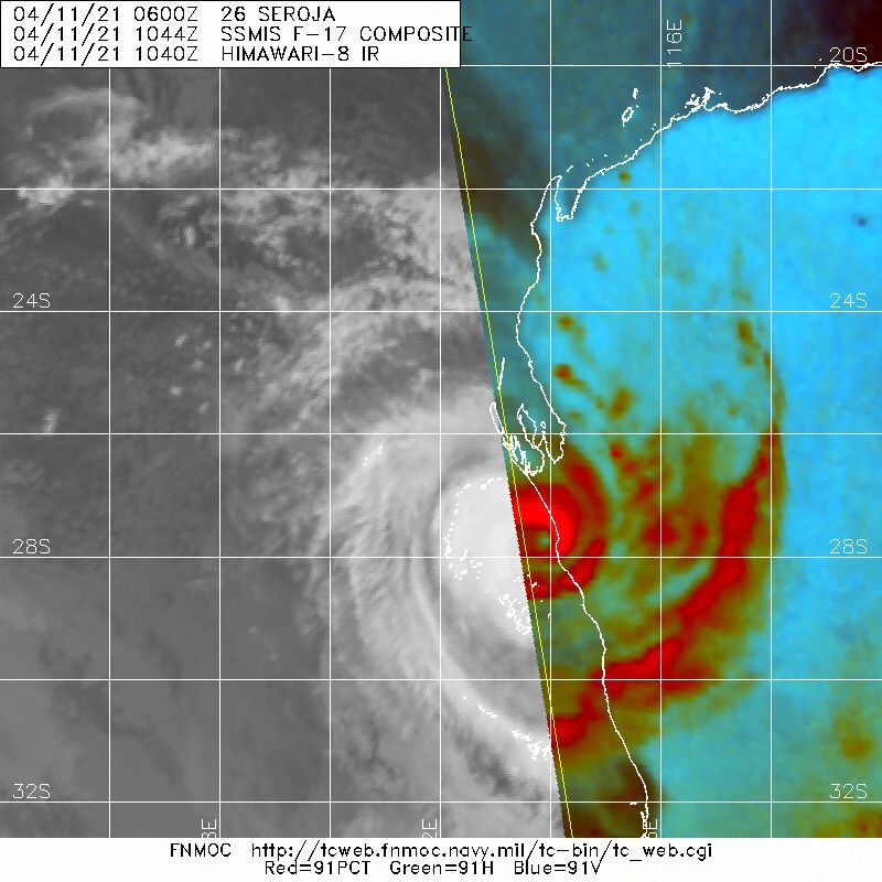
20210411.1044.f17.91pct91h91v.26S.SEROJA.70kts.972mb.26.1S.112E.045pc.jpg 20210411.1044.f17.91h.26S.SEROJA.70kts.972mb.26.1S.112E.045pc.jpg
回復

使用道具 舉報

簽到天數: 483 天

[LV.9]以壇為家II

dom|2021-4-11 20:33 | 顯示全部樓層
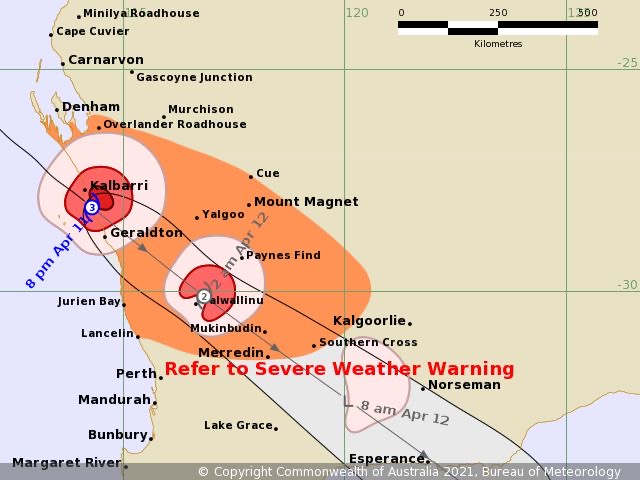
BoM判定登陸澳洲
Headline:

The eye of severe tropical cyclone Seroja has moved onto the coast south of Kalbarri.


Areas affected:

Warning zone: Overlander Roadhouse to Lancelin along the coast, extending to inland areas including Mount Magnet, Paynes Find, Dalwallinu, Mukinbudin, Merredin and Southern Cross.

Watch zone: None.

Cancelled zones: Minilya Roadhouse to Overlander Roadhouse.


Details of Severe Tropical Cyclone Seroja at 8:00 pm AWST:

Intensity: category 3, sustained winds near the centre of 120 kilometres per hour with wind gusts to 165 kilometres per hour.
Location: within 20 kilometres of 28.1 degrees South, 114.3 degrees East , 45 kilometres south southeast of Kalbarri and 80 kilometres north northwest of Geraldton .
Movement: southeast at 53 kilometres per hour .

The core of severe tropical cyclone Seroja is moving onto the coast south of Kalbarri, where wind gusts to 170 km/h have been reported. Impacts are otherwise occurring about the coast and adjacent inland between Denham and Geraldton.

Seroja is travelling at around 55 kilometres per hour, and significant impacts are expected to extend south and inland through to Wheat Belt communities overnight.

The cyclone will weaken as it moves further inland on Monday but is still likely to result in damaging wind gusts, particularly to the north and east of the track, and heavy rain close to the track, as it moves through the eastern Wheat Belt, southern Goldfields and South East Coastal district. A Severe Weather Warning is current for areas to the southeast of the Tropical Cyclone Warning area.


Hazards:

VERY DESTRUCTIVE WINDS, with gusts to 170 kilometres per hour, have occurred in Kalbarri and nearby areas to the south and east as the core of Severe Tropical Cyclone Seroja crosses the coast.

DESTRUCTIVE WINDS with gusts to 150 kilometres per hour are occurring on the coast between Billabong Roadhouse and Geraldton, and will extend inland overnight tonight. Destructive gusts above 125 kilometres per hour may extend inland as far as a line from Dalwallinu to Paynes Find, including Morawa. Towns in this area very rarely experience wind gusts this strong.

GALES with gusts to 100 kilometres per hour are occurring on the coast between Denham and south of Geraldton, and extend inland to Chapman Valley and Binnu. Gales will extend south of Geraldton during the next few hours, and extend inland into the southern Gascoyne and northern Wheatbelt overnight.

People near Geraldton are experiencing intermittent GALES, and are likely to experience a brief period of DESTRUCTIVE winds around 9 pm.

Seroja is moving fast, so weather conditions will deteriorate rapidly as it approaches.

HEAVY TO INTENSE RAINFALL and FLASH FLOODING are likely close to the track of Seroja during Sunday evening and Monday.

ABNORMALLY HIGH TIDES could cause minor inundation at the coast between Coral Bay and Lancelin, increasing to SERIOUS FLOODING in the Denham and Shark Bay region and near Kalbarri. Dangerous surf and beach erosion is expected between Denham and Geraldton.


Recommended Action:

.DFES advises of the following community alerts effective as of 8:00 PM Sunday 11th April 2021.

Cyclone RED ALERT for south of Carnarvon to Lancelin, including the Shires of Shark Bay, Northampton, Chapman Valley, Morawa, City of Greater Geraldton, Mingenew, Three Springs, Perenjori, Irwin the townsites of Coorow and Carnamah in the Midwest Gascoyne

Cyclone YELLOW ALERT is current for people between Minilya Roadhouse to Carnarvon in the Midwest Gascoyne

Cyclone Blue Alert is current for people near the locations of Wongan Ballidu, Mt Marshall, Trayning, Koorda, Nungarin, Mukinbudin & Dalwallinu.

People needing SES assistance can call 132 500. In a life-threatening situation call 000. For more safety tips visit www.emergency.wa.gov.au
9F708B70-E68C-4DEA-B5A1-F9AEB21BADC0.jpeg 16974F4C-5E78-4BE0-8BFC-A61838C2208B.jpeg
回復

使用道具 舉報

快速回覆
您需要登錄後才可以回帖 登錄 | 立即加入

本版積分規則

本平台僅供學術討論之用,預報應以氣象局為準

威普網站虛擬主機贊助公司

臺灣第一個天氣類型社群平台 即時天氣資訊、精準颱風動態

線上客服
FB傳送訊息
廣告行銷
精準行銷 物超所值
官方粉專
發佈 快速回復 返回頂部 返回列表