開啟輔助訪問
 找回密碼
 立即加入

03E.Carlos

簽到天數: 483 天

[LV.9]以壇為家II

dom|2021-6-7 20:50 | 顯示全部樓層
展望降至Medium
ZCZC MIATWOEP ALL
TTAA00 KNHC DDHHMM

Tropical Weather Outlook
NWS National Hurricane Center Miami FL
500 AM PDT Mon Jun 7 2021

For the eastern North Pacific...east of 140 degrees west longitude:

1. Showers and thunderstorms continue in association with an area of
low pressure located about 400 miles south-southeast of Socorro
Island.  However, the system still lacks a well-defined center, as
recent satellite imagery indicates the low-level circulation remains
broad and displaced well east of the thunderstorm activity.  The
disturbance still has the potential to become a short-lived tropical
depression today before environmental conditions become less
favorable for development by tonight.  The system is forecast to
move slowly west-southwestward during the next couple of days.
* Formation chance through 48 hours...medium...60 percent.
* Formation chance through 5 days...medium...60 percent.

2. A broad trough of low pressure is expected to form a couple of
hundred miles south of the coasts of southern Mexico, El Salvador,
and Guatemala in a day or two.  Environmental conditions appear
favorable for some development thereafter, and a tropical depression
could form by the end of the week as the system moves slowly
northwestward or northward.
* Formation chance through 48 hours...low...near 0 percent.
* Formation chance through 5 days...medium...40 percent.

Forecaster Reinhart/Blake
two_pac_2d1.png
回復

使用道具 舉報

簽到天數: 1650 天

[LV.Master]伴壇終老

老農民版夜神月|2021-6-7 03:54 | 顯示全部樓層
NHC展望仍維持90%,目前數值不太支持長期發展,要拚升格可能得盡快了
1. Satellite imagery indicates that an area of low pressure located
several hundred miles south-southwest of Manzanillo, Mexico is
producing an organized area of showers and thunderstorms and could
be developing a better-defined surface circulation.  This system
will likely become a tropical depression by tonight while it moves
slowly westward.  Upper-level winds are expected to become less
favorable for additional development in a couple of days.
* Formation chance through 48 hours...high...90 percent.
* Formation chance through 5 days...high...90 percent.

two_pac_2d0.png two_pac_2d1 (6).png
two_pac_5d1 (3).png epac.png
92E_gefs_latest (1).png
回復

使用道具 舉報

簽到天數: 483 天

[LV.9]以壇為家II

dom|2021-6-6 15:54 | 顯示全部樓層
NHC展望提升至90%
ZCZC MIATWOEP ALL
TTAA00 KNHC DDHHMM

Tropical Weather Outlook
NWS National Hurricane Center Miami FL
1100 PM PDT Sat Jun 5 2021

For the eastern North Pacific...east of 140 degrees west longitude:

1. Showers and thunderstorms have become better organized during the
past few hours in association with an area of low pressure located
about 450 miles south-southwest of Manzanillo, Mexico.  In addition,
satellite images suggest that the low-level circulation is gradually
becoming better defined.  This system will likely become a tropical
depression on Sunday while it moves slowly westward.  Environmental
conditions are expected to become less conducive for additional
development in a couple of days.
* Formation chance through 48 hours...high...90 percent.
* Formation chance through 5 days...high...90 percent.

2. A broad trough of low pressure is expected to form a couple of
hundred miles south of the coasts of El Salvador and Guatemala in a
few days. Gradual development of this system is possible thereafter
while it drifts northwestward through the end of next week.
* Formation chance through 48 hours...low...near 0 percent.
* Formation chance through 5 days...low...30 percent.

Forecaster Cangialosi
79BD3716-834B-49AB-A9CA-CB1BB6A34672.png
回復

使用道具 舉報

簽到天數: 1650 天

[LV.Master]伴壇終老

老農民版夜神月|2021-6-5 19:55 | 顯示全部樓層
NHC展望提升至High,80%
ZCZC MIATWOEP ALL
TTAA00 KNHC DDHHMM

Tropical Weather Outlook
NWS National Hurricane Center Miami FL
500 AM PDT Sat Jun 5 2021

For the eastern North Pacific...east of 140 degrees west longitude:

1. Showers and thunderstorms have become better organized overnight in
association with a broad area of low pressure located about 500
miles south-southwest of Manzanillo, Mexico.  Environmental
conditions appear conducive for additional development, and a
tropical depression is likely to form today or tomorrow while it
moves slowly to the west well off the coast of Mexico.
* Formation chance through 48 hours...high...80 percent.
* Formation chance through 5 days...high...80 percent.

Forecaster Papin/Blake
two_pac_2d1 (5).png two_pac_5d1 (2).png
回復

使用道具 舉報

簽到天數: 483 天

[LV.9]以壇為家II

dom|2021-6-5 11:03 | 顯示全部樓層
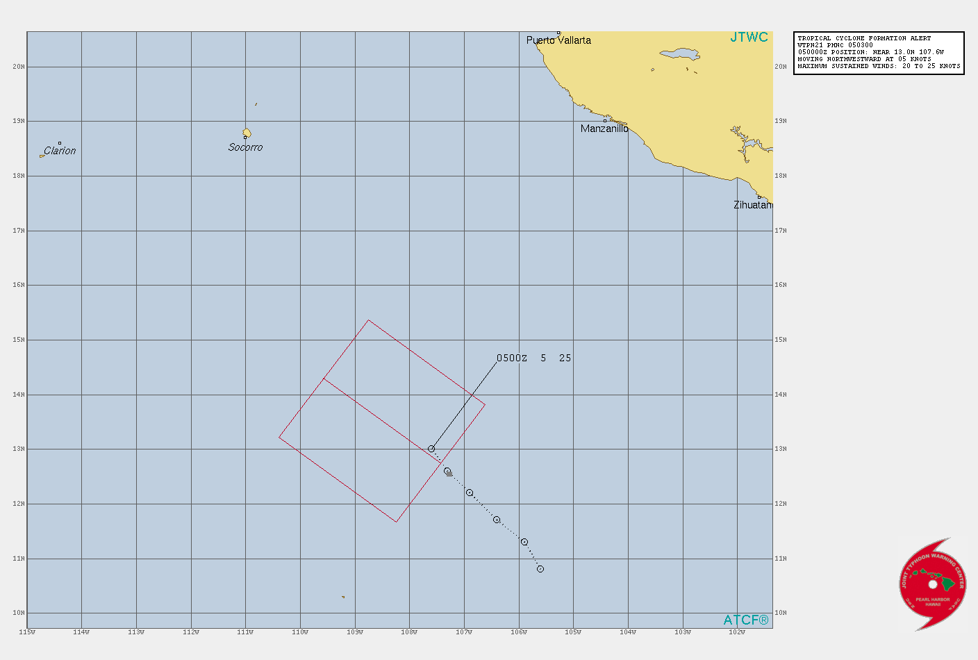
JTWC03Z發佈TCFA
WTPN21 PHNC 050300
MSGID/GENADMIN/JOINT TYPHOON WRNCEN PEARL HARBOR HI//
SUBJ/TROPICAL CYCLONE FORMATION ALERT (INVEST 92E)//
RMKS/
1. FORMATION OF A SIGNIFICANT TROPICAL CYCLONE IS POSSIBLE WITHIN
080 NM EITHER SIDE OF A LINE FROM 12.8N 107.4W TO 14.3N 109.6W
WITHIN THE NEXT 12 TO 24 HOURS. AVAILABLE DATA DOES NOT JUSTIFY
ISSUANCE OF NUMBERED TROPICAL CYCLONE WARNINGS AT THIS TIME.
WINDS IN THE AREA ARE ESTIMATED TO BE 20 TO 25 KNOTS. METSAT
IMAGERY AT 050130Z INDICATES THAT A CIRCULATION CENTER IS LOCATED
NEAR 13.0N 107.6W. THE SYSTEM IS MOVING NORTHWESTWARD AT 05
KNOTS.
2. REMARKS: AN AREA OF CONVECTION (INVEST 92E) IS LOCATED NEAR 13.0N
107.6W, APPROXIMATELY 1285 NM SOUTH-SOUTHEAST OF SAN DIEGO,
CALIFORNIA. ANIMATED ENHANCED INFRARED SATELLITE IMAGERY (EIR) AND A
050156Z SSMIS 91GHZ MICROWAVE IMAGE DEPICT AREAS OF DEEP CONVECTION
WRAPPING INTO A LOW LEVEL CIRCULATION CENTER (LLCC). ENVIRONMENTAL
ANALYSIS INDICATES FAVORABLE CONDITIONS FOR DEVELOPMENT WITH
SUPPORTING DIVERGENCE ALOFT, LOW (10-15 KTS) VERTICAL WIND SHEAR
(VWS), AND WARM (30C) SEA SURFACE TEMPERATURES. NUMERICAL MODELS ARE
IN GENERAL AGREEMENT THAT INVEST 92E WILL TRACK WEST-NORTHWESTWARD
AS IT INTENSIFIES. MAXIMUM SUSTAINED SURFACE WINDS ARE ESTIMATED AT
20 TO 25 KNOTS. MINIMUM SEA LEVEL PRESSURE IS ESTIMATED TO BE NEAR
1004 MB. THE POTENTIAL FOR THE DEVELOPMENT OF A SIGNIFICANT TROPICAL
CYCLONE WITHIN THE NEXT 24 HOURS IS HIGH.
3. THIS ALERT WILL BE REISSUED, UPGRADED TO WARNING OR CANCELLED BY
060300Z.//
NNNN
105509j5t7tr2gcxmkt75g.gif
回復

使用道具 舉報

簽到天數: 1650 天

[LV.Master]伴壇終老

老農民版夜神月|2021-6-5 06:13 | 顯示全部樓層
NHC展望提升至Medium,50%
1. An area of low pressure has developed within a larger-scale trough
located several hundred miles south of Manzanillo, Mexico. Showers
and thunderstorms associated with this system have become better
organized today, and further development is now expected. A
tropical depression is likely to form by early next week as it
moves slowly to the west-northwest well off the coast of Mexico.
* Formation chance through 48 hours...medium...50 percent.
* Formation chance through 5 days...high...70 percent.
two_pac_2d1 (1).png two_pac_5d1 (1).png
92E_intensity_latest.png 92E_gefs_latest.png
回復

使用道具 舉報

123
快速回覆
您需要登錄後才可以回帖 登錄 | 立即加入

本版積分規則

本平台僅供學術討論之用,預報應以氣象局為準

威普網站虛擬主機贊助公司

臺灣第一個天氣類型社群平台 即時天氣資訊、精準颱風動態

線上客服
FB傳送訊息
廣告行銷
精準行銷 物超所值
官方粉專
發佈 快速回復 返回頂部 返回列表