開啟輔助訪問
 找回密碼
 立即加入

03L.Claudette 登陸路州

簽到天數: 1650 天

[LV.Master]伴壇終老

2021-6-13 02:46 | 顯示全部樓層
  熱帶風暴  
編號:03 L
名稱:Claudette
052251mngny8rshaqz76gz.jpg
  基本資料  
擾動編號日期:2021 06 13 02
命名日期  :2021 06 19 17
撤編日期  :2021 06 23 08
登陸地點  :美國 路易斯安那州

  巔峰時期資料  
近中心最強風速 :40  kt ( TS )
海平面最低氣壓 :1007 百帕

  擾動編號資料  
92L.INVEST.15kts.1007mb.20N.94W
20210612.1820.goes-16.vis.2km.92L.INVEST.15kts.1007mb.20N.94W.pc.jpg

  NHC:10%  

1. An area of cloudiness and showers over the Bay of Campeche and the
adjacent land areas is associated with a trough of low pressure.  
Slow development of this system is possible over the next several
days as it moves slowly and erratically, and a tropical depression
could form in this area by the middle of next week.  Regardless of
development, due to the slow motion heavy rainfall is possible over
portions of Central America and southern Mexico.  Please consult
products from your local meteorological service for more
information.
* Formation chance through 48 hours...low...10 percent.
* Formation chance through 5 days...medium...40 percent.

two_atl_2d1.png
two_atl_5d1.png
以上資料來自:NHC、颱風論壇整理製作

評分

參與人數 1水氣能量 +15 +1 收起 理由
t02436 + 15 + 1

查看全部評分

回復

使用道具 舉報

簽到天數: 483 天

[LV.9]以壇為家II

dom|2021-6-22 21:29 | 顯示全部樓層
NHC12Z撤銷評級
ZCZC MIATWOAT ALL
TTAA00 KNHC DDHHMM

Tropical Weather Outlook
NWS National Hurricane Center Miami FL
800 AM EDT Tue Jun 22 2021

For the North Atlantic...Caribbean Sea and the Gulf of Mexico:

1. Showers and thunderstorms have increased in coverage associated with
the tropical wave located more than 500 miles east of the Windward
Islands. Some additional development of this disturbance is possible
over the next couple of days before upper-level winds become less
conducive for further organization by Thursday. The system is
expected to move westward to west-northwestward at 15 to 20 mph.
* Formation chance through 48 hours...low...30 percent.
* Formation chance through 5 days...low...30 percent.

Forecaster Papin/Cangialosi
F3A99CD0-618A-4788-930D-45B5865CF844.png
回復

使用道具 舉報

簽到天數: 483 天

[LV.9]以壇為家II

dom|2021-6-22 11:06 | 顯示全部樓層
NHC判定成為殘餘低壓
888
WTNT43 KNHC 220257
TCDAT3

Remnants Of Claudette Discussion Number  18
NWS National Hurricane Center Miami FL       AL032021
1100 PM AST Mon Jun 21 2021

Recent scatterometer data show that the system has opened up into a
northwest to southeast-oriented trough.  Therefore Claudette has
dissipated as a tropical cyclone and this is the last advisory.  The
remnants of Claudette should continue to move rapidly
east-northeastward and weaken over the next day or so.

Additional information on the remnants of Claudette can be found in
High Seas Forecasts issued by the National Weather Service, under
AWIPS header NFDHSFAT1, WMO header FZNT01 KWBC, and online at
ocean.weather.gov/shtml/NFDHSFAT1.php

FORECAST POSITIONS AND MAX WINDS

INIT  22/0300Z 39.0N  69.0W   40 KT  45 MPH
12H  22/1200Z...DISSIPATED

$$
Forecaster Pasch
025814_5day_cone_no_line_and_wind.png
回復

使用道具 舉報

簽到天數: 1650 天

[LV.Master]伴壇終老

老農民版夜神月|2021-6-22 00:28 | 顯示全部樓層
NHC認定已出海,並預測將逐漸轉化
000
WTNT43 KNHC 211449
TCDAT3

Tropical Storm Claudette Discussion Number  16
NWS National Hurricane Center Miami FL       AL032021
1100 AM EDT Mon Jun 21 2021

Claudette's low-level center is estimated to be back over water.
However, it is difficult to locate in surface observation data due
to the broad inner-core wind field and elongated pressure envelope
near the NC/VA coasts in which the cyclone is embedded. For now, the
surface center has been placed close to the low- to mid-level
circulation center noted in KAKQ and KMHX Doppler radar data. The
initial intensity is being maintained at 35 kt based on a 1200 UTC
32-kt wind report from ship 3EVZ8 located about 130 nmi southeast of
the center.

Claudette continues to accelerate east-northeastward and the motion
is now 060/24 kt. The track forecast and discussion remain pretty
straightforward. Claudette is now caught up in the deep-layer
west-southwesterly flow on the north side of a broad subtropical
ridge and ahead of a mid-latitude trough currently moving into the
eastern and southeastern United States. The cyclone or its remnants
will gradually lift out toward the northeast ahead of the
approaching mid-latitude trough by tonight, with that motion
continuing through Tuesday. The new NHC track forecast is similar to
the previous advisory track, and lies close to a blend of consensus
track models TVCA, GFEX, and HCCA.

As Claudette continues to accelerate, its increased forward speed
could result in the low-level wind field opening up into a trough,
which would result in the cessation of the system as a tropical
cyclone. For now, however, the assumption is that the cyclone could
strengthen a little more, which would allow for the surface wind
field to remain closed today and into Tuesday until the system
weakens over the cold North Atlantic waters north of the Gulf
Stream, which is located along roughly 38N latitude. As a result,
Claudette is forecast to become a post-tropical remnant low in
about 24 h, follows by dissipation in about 48 h. The official NHC
intensity forecast remains very similar to the previous one, and the
track closely follows the intensity consensus models HCCA and IVCN.

Key Message:

1. Heavy rain from Claudette will continue to diminish this morning
across far southeast Virginia and the Outer Banks of North Carolina.
Isolated flash, urban, and small stream flooding impacts are
possible.


FORECAST POSITIONS AND MAX WINDS

INIT  21/1500Z 37.0N  75.0W   35 KT  40 MPH
12H  22/0000Z 38.7N  71.1W   40 KT  45 MPH
24H  22/1200Z 41.8N  65.4W   40 KT  45 MPH...POST-TROP/EXTRATROP
36H  23/0000Z 44.8N  59.9W   40 KT  45 MPH...POST-TROP/EXTRATROP
48H  23/1200Z...DISSIPATED

$$
Forecaster Stewart
145037_5day_cone_no_line_and_wind.png al032021 (8).gif
sfcplot_03L_latest (3).png 20211721510_GOES16-ABI-FL-GEOCOLOR-AL032021-1000x1000.jpg
回復

使用道具 舉報

簽到天數: 483 天

[LV.9]以壇為家II

dom|2021-6-21 17:14 | 顯示全部樓層
NHC09Z升格TS
000
WTNT43 KNHC 210841
TCDAT3

Tropical Storm Claudette Discussion Number  15
NWS National Hurricane Center Miami FL       AL032021
500 AM EDT Mon Jun 21 2021

The elongated low-level center of Claudette is located over eastern
North Carolina this morning, while a curved band of convection
continues pushing eastward across the adjacent coastal and offshore
waters. Surface pressures have fallen slightly overnight near the
estimated center position, and Frying Pan Shoals buoy 41013 off the
coast of southeastern North Carolina reported a brief period of
sustained tropical-storm-force winds shortly after 06 UTC.
Therefore, Claudette's initial intensity is raised to 35 kt with
this advisory, making it a tropical storm once again.

Claudette continues to accelerate east-northeastward as it is
steered by a mid- to upper-level trough that is approaching the
eastern United States. The storm will move off the North Carolina
coast within the next few hours, and a bit more strengthening is
possible today as it passes near the north wall of the Gulf Stream.
The official NHC forecast hangs onto Claudette as a tropical cyclone
through tonight, then quickly transitions it to a post-tropical
cyclone by 36 h. The time of dissipation is also moved up a day
earlier with this advisory, which is consistent with the latest
global model fields that show an open trough approaching Atlantic
Canada. Otherwise, the official NHC forecast remains very similar to
the previous one, and the track closely follows the multi-model
consensus.

Some of the global guidance suggests that Claudette could lose its
closed low-level circulation and open up into a trough soon after
emerging into the western Atlantic Ocean later today.  Given the
current poor center definition, it is a plausible alternative
scenario that Claudette dissipates faster than shown below.


Key Messages:

1. Heavy rain from Claudette will continue over the North Carolina
coast this morning. Isolated flash, urban, and small stream
flooding impacts are possible.

2. Tropical storm conditions are expected along portions of the
North Carolina coast through this morning, where a Tropical Storm
Warning is in effect.


FORECAST POSITIONS AND MAX WINDS

INIT  21/0900Z 35.6N  77.6W   35 KT  40 MPH...INLAND
12H  21/1800Z 37.0N  74.1W   40 KT  45 MPH...OVER WATER
24H  22/0600Z 39.5N  68.6W   40 KT  45 MPH
36H  22/1800Z 42.8N  63.3W   40 KT  45 MPH...POST-TROP/EXTRATROP
48H  23/0600Z...DISSIPATED

$$
Forecaster Reinhart/Blake
C24DBE84-2863-4CE1-AE81-D8E41C1B92E0.png
回復

使用道具 舉報

簽到天數: 1650 天

[LV.Master]伴壇終老

老農民版夜神月|2021-6-21 05:17 | 顯示全部樓層
NHC目前仍將其維持為TD,並預測+24H內將以TS強度出海,+48H後將轉溫
295
WTNT43 KNHC 202032
TCDAT3

Tropical Depression Claudette Discussion Number  13
NWS National Hurricane Center Miami FL       AL032021
500 PM EDT Sun Jun 20 2021

Satellite and surface observations show that Claudette's circulation
has become elongated today and that there is a fairly large area of
light winds near the center.  Observations along the southeastern
U.S. coast and over coastal sections of the Carolinas indicate that
the winds have increased somewhat but these data still support an
initial intensity of 25 kt.   As Claudette approaches the coast
overnight and Monday morning, restrengthening is anticipated, and
the cyclone is forecast to regain tropical storm status before it
exits the coast of North Carolina. Some additional strengthening
is forecast while Claudette moves over the warm waters of the Gulf
Stream and the shear remains low.  The system should become
extratropical Tuesday afternoon when it passes near Nova Scotia,
and the global models indicate that it will degenerate into a
trough of low pressure by Wednesday morning.  The NHC intensity
foreast is close to the intensity model consensus and follows the
trends of the various global models.

The depression is moving east-northeastward at around 15 kt.  A
mid-latitude trough that is moving into the central United States
should continue to steer Claudette east-northeastward to
northeastward over the next couple of days.  The center of Claudette
is forecast to move offshore of the coast of North Carolina Monday
morning, then pass well offshore of the Mid-Atlantic coast Monday
night, and be near or just southeast of Nova Scotia on Tuesday.
The dynamical model guidance remains in very good agreement and the
NHC forecast again lies near the various consensus aids.


Key Messages:

1. Claudette is expected to produce heavy rainfall and flash
flooding from North Florida and southeastern Georgia into the
Carolinas through Monday morning. Flash, urban, and small stream
flooding impacts are possible across these areas.

2. Isolated tornadoes are possible this evening across parts of the
central and eastern Carolinas.

3. Tropical storm conditions are expected along portions of the
North Carolina coast late tonight and Monday, where a Tropical Storm
Warning is in effect.  Tropical storm conditions are possible in
northeastern South Carolina tonight and Monday, where a Tropical
Storm Watch is in effect.


FORECAST POSITIONS AND MAX WINDS

INIT  20/2100Z 34.2N  82.5W   25 KT  30 MPH
12H  21/0600Z 35.0N  79.1W   35 KT  40 MPH...INLAND
24H  21/1800Z 36.9N  74.3W   40 KT  45 MPH...OVER WATER
36H  22/0600Z 39.3N  69.0W   40 KT  45 MPH
48H  22/1800Z 42.4N  63.4W   40 KT  45 MPH...POST-TROP/EXTRATROP
60H  23/0600Z 45.5N  58.4W   35 KT  40 MPH...POST-TROP/EXTRATROP
72H  23/1800Z...DISSIPATED

$$
Forecaster Brown

205000_5day_cone_no_line_and_wind.png al032021 (7).gif
sfcplot_03L_latest (2).png GOES211120211710RAsex.jpg
回復

使用道具 舉報

簽到天數: 1650 天

[LV.Master]伴壇終老

老農民版夜神月|2021-6-20 05:44 | 顯示全部樓層
NHC21Z降格TD
361
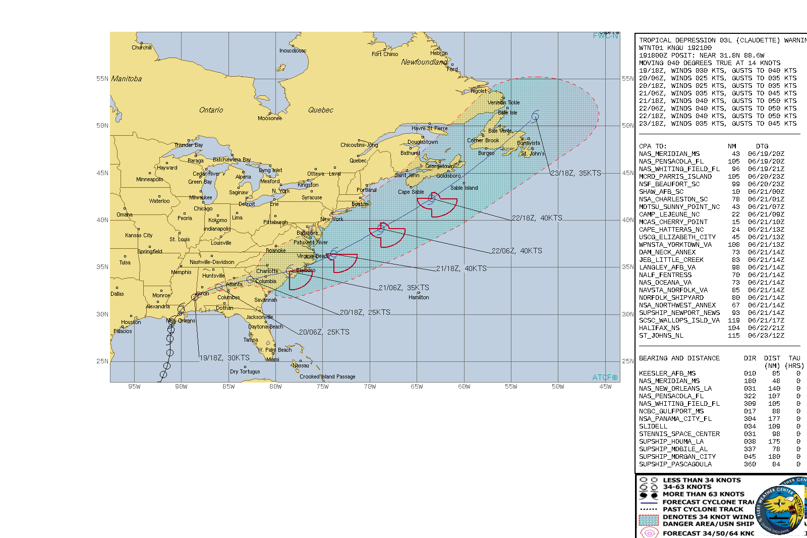
WTNT43 KNHC 192033
TCDAT3

Tropical Depression Claudette Discussion Number   9
NWS National Hurricane Center Miami FL       AL032021
400 PM CDT Sat Jun 19 2021

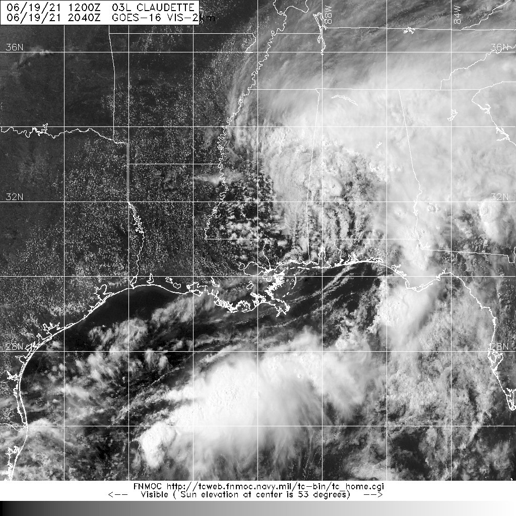
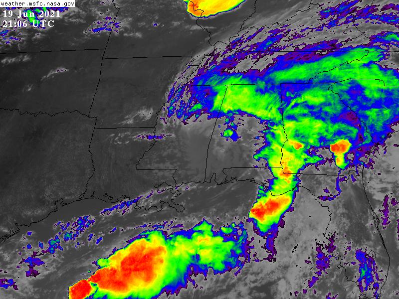
Claudette continues to move inland with its center now located
over southwestern Alabama.  Surface observations indicate that the
system has weakened, and based on that information the initial
intensity is lowered to 30 kt.  This makes Claudette a tropical
depression.  The cyclone is still producing gusty winds and bands
of heavy rain across portions of Mississippi, Alabama, Georgia, and
the Florida Panhandle.

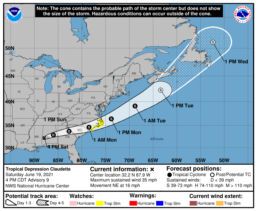
As expected, the tropical depression has turned to the northeast
and accelerated some, with the latest initial motion estimated to
be 040/14 kt.  A turn to the east-northeast is expected
tonight and Sunday as Claudette moves in the westerlies on the
north side of the subtropical ridge.  This motion should take the
system across portions of the southeast U.S. during the next couple
of days and then over the western Atlantic and toward Atlantic
Canada early next week.  The models remain in relatively good
agreement, and the NHC track forecast lies near the middle of the
guidance envelope.  This forecast is very similar to the previous
one, except again a little to the right at the longer range forecast
times.

Some additional weakening seems likely during the next day or so
while Claudette moves across the southeast U.S.  However, most of
the models show the system regaining some strength when it moves
across the Carolinas and over the western Atlantic waters Sunday
night and Monday.  This predicted strengthening is likely due in
part to baroclinic processes. The 12Z ECMWF is weaker than previous
runs, and overall the remainder of the intensity guidance is largely
unchanged from the previous cyclone.  Based on the latest models,
the NHC intensity forecast is just an update of previous one and
lies near the HCCA and IVCN consensus aids. Once the system moves
north of the Gulf Stream Current in a few days, it is forecast to
transition to an extratropical cyclone prior to reaching Atlantic
Canada.

Key Messages:

1. Claudette is expected to produce heavy rainfall and flash
flooding across portions of the Florida Panhandle, eastern Alabama,
and Georgia through tonight, and into the Carolinas on Sunday.
Considerable flash, urban, and small stream flooding impacts are
expected across these areas.

2. Tropical storm conditions are possible along portions of the
North Carolina coast Sunday night and Monday, where a Tropical Storm
Watch is in effect.


FORECAST POSITIONS AND MAX WINDS

INIT  19/2100Z 32.2N  87.9W   30 KT  35 MPH...INLAND
12H  20/0600Z 32.9N  86.0W   25 KT  30 MPH...INLAND
24H  20/1800Z 33.7N  82.7W   25 KT  30 MPH...INLAND
36H  21/0600Z 34.6N  78.5W   35 KT  40 MPH...INLAND
48H  21/1800Z 36.4N  73.8W   40 KT  45 MPH...OVER WATER
60H  22/0600Z 39.1N  68.8W   40 KT  45 MPH
72H  22/1800Z 42.3N  63.4W   40 KT  45 MPH...POST-TROP/EXTRATROP
96H  23/1800Z 51.0N  52.4W   35 KT  40 MPH...POST-TROP/EXTRATROP
120H  24/1800Z...DISSIPATED

$$
Forecaster Cangialosi
203740_5day_cone_no_line_and_wind.png al032021 (4).gif
20210619.2040.goes-16.vis.2km.03L.CLAUDETTE.40kts.1006mb.30.5N.90W.pc.jpg GOES21062021170s586bZ.jpg
回復

使用道具 舉報

簽到天數: 483 天

[LV.9]以壇為家II

dom|2021-6-19 17:19 | 顯示全部樓層
NHC命名Claudette,判定達到巔峰並登陸紐奧良,出海後有望短暫增強為TS
000
WTNT43 KNHC 190859
TCDAT3

Tropical Storm Claudette Discussion Number   7
NWS National Hurricane Center Miami FL       AL032021
400 AM CDT Sat Jun 19 2021

The system that we have been tracking for a few days finally has
enough of a well-defined center and organized convection to be
considered a tropical storm.  While the organization is not
classical by any means, and there are some hybrid characteristics,
the cyclone most resembles a sheared tropical storm, so the system
is now Tropical Storm Claudette.  The initial wind speed remains 40
kt, in line with surface observations and radar.  These winds are
primarily occurring in a strong band on the eastern side of the
cyclone well away from the center.

Claudette is moving north-northeastward at about 10 kt.  The storm
should turn northeastward and east-northeastward over the next day
or so while it moves around the northern side of the subtropical
ridge and gradually weakens to a depression/post-tropical cyclone.  
The biggest change to the forecast is that almost all of the
reliable global models, save the GFS, are showing the system
regenerating near or offshore of the North Carolina coast in 60 to
72 hours.  Thus the forecast has been extended from the last one
and now shows the system as a tropical cyclone over the western
Atlantic Ocean.  The new intensity forecast is more conservative
than most of the guidance, but is higher than the previous advisory.
Extratropical transition is expected by 96 hours near Nova Scotia.

Given the current and anticipated structure of this system, users
should not focus on the exact track of the center, as rainfall and
wind hazards are likely to extend well east of the center.  Impacts
along the northern Gulf coast will continue.

Key Messages:

1. Claudette is expected to produce heavy rainfall and
life-threatening flash flooding across coastal Mississippi and
Alabama, and the far western Florida Panhandle through the
afternoon. Considerable flash, urban, and small stream flooding,
will continue through the weekend along the central Gulf Coast,
with flood impacts spreading northeastward into interior portions
of the Southeast.  

2. Tropical storm conditions are occurring along portions of the
central Gulf Coast from east of Morgan City, Louisiana, to the
Okaloosa/Walton County line, Florida, including New Orleans.  These
winds will spread inland and continue through this afternoon.


FORECAST POSITIONS AND MAX WINDS

INIT  19/0900Z 29.6N  90.7W   40 KT  45 MPH...INLAND
12H  19/1800Z 30.9N  89.7W   35 KT  40 MPH...INLAND
24H  20/0600Z 32.2N  87.6W   25 KT  30 MPH...INLAND
36H  20/1800Z 33.3N  84.2W   25 KT  30 MPH...POST-TROP/INLAND
48H  21/0600Z 34.2N  80.5W   25 KT  30 MPH...POST-TROP/INLAND
60H  21/1800Z 35.8N  76.0W   30 KT  35 MPH...POST-TROP/INLAND
72H  22/0600Z 38.5N  71.0W   35 KT  40 MPH...TROPICAL CYCLONE
96H  23/0600Z 47.0N  61.0W   35 KT  40 MPH...POST-TROP/EXTRATROP
120H  24/0600Z...DISSIPATED

$$
Forecaster Blake
CE0347D8-1907-470D-AC2F-F3C81057B188.png
回復

使用道具 舉報

123下一頁
快速回覆
您需要登錄後才可以回帖 登錄 | 立即加入

本版積分規則

本平台僅供學術討論之用,預報應以氣象局為準

威普網站虛擬主機贊助公司

臺灣第一個天氣類型社群平台 即時天氣資訊、精準颱風動態

線上客服
FB傳送訊息
廣告行銷
精準行銷 物超所值
官方粉專
發佈 快速回復 返回頂部 返回列表