簽到天數: 3279 天 [LV.Master]伴壇終老
|
 t02436|2017-5-1 11:42
|
顯示全部樓層
這次預報失誤似乎蠻多的,從原先展望的不看好,到急速命名並上望二級熱帶氣旋,結果21Z降格...
IDW27700
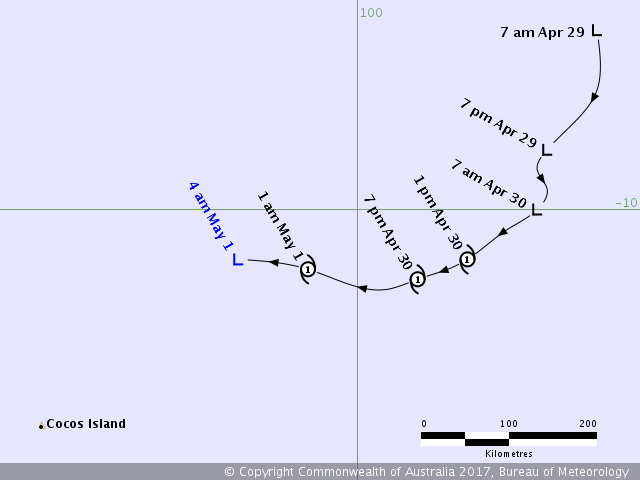
TROPICAL CYCLONE TECHNICAL BULLETIN: AUSTRALIA - WESTERN REGION
Issued by PERTH TROPICAL CYCLONE WARNING CENTRE
at: 2249 UTC 30/04/2017
Name: Ex-Tropical Cyclone Greg
Identifier: 30U
Data At: 2100 UTC
Latitude: 10.5S
Longitude: 98.8E
Location Accuracy: within 20 nm [35 km]
Movement Towards: west [270 deg]
Speed of Movement: 9 knots [16 km/h]
Maximum 10-Minute Wind: 30 knots [55 km/h]
Maximum 3-Second Wind Gust: 45 knots [85 km/h]
Central Pressure: 1002 hPa
Radius of 34-knot winds NE quadrant:
Radius of 34-knot winds SE quadrant:
Radius of 34-knot winds SW quadrant:
Radius of 34-knot winds NW quadrant:
Radius of 48-knot winds NE quadrant:
Radius of 48-knot winds SE quadrant:
Radius of 48-knot winds SW quadrant:
Radius of 48-knot winds NW quadrant:
Radius of 64-knot winds:
Radius of Maximum Winds:
Dvorak Intensity Code: T2.0/2.5/S0.0/24HRS STT:W0.5/06HRS
Pressure of outermost isobar: 1010 hPa
Radius of outermost closed isobar: 80 nm [150 km]
FORECAST DATA
Date/Time : Location : Loc. Accuracy: Max Wind : Central Pressure
[UTC] : degrees : nm [km]: knots[km/h]: hPa
+06: 01/0300: 10.5S 97.9E: 040 [080]: 030 [055]: 1004
+12: 01/0900: 10.4S 97.1E: 055 [100]: 030 [055]: 1005
+18: 01/1500: 10.4S 96.1E: 065 [125]: 030 [055]: 1006
+24: 01/2100: 10.4S 95.0E: 080 [145]: 030 [055]: 1006
+36: 02/0900: 10.4S 93.2E: 100 [185]: 025 [045]: 1008
+48: 02/2100: 10.8S 91.3E: 120 [220]: 025 [045]: 1008
+60: 03/0900: 10.9S 89.4E: 140 [255]: 025 [045]: 1008
+72: 03/2100: 11.0S 87.6E: 155 [290]: 025 [045]: 1008
+96: 04/2100: 12.0S 83.7E: 200 [370]: 025 [045]: 1008
+120: 05/2100: : : :
REMARKS:
TC Greg has been located by microwave and IR imagery with the IR showing the low
level centre well west of the deep convection.
With the LLC about 1.25 degrees from the deep convection, Dvorak shear pattern
gives a DT of 1.5. A weakening trend gives MET of 2.0, PAT adjusted to 1.5. FT
is 2.0 due to constraints and CI is held 0.5 higher at 2.5. This gives a max 10
minute wind of 30 knots and the system is below tropical cyclone intensity.
The environment is forecast to further deteriorate during Monday as shear
increases and with the possible entrainment of dry air. Thus, further weakening
is likely.
With steering being dominated by a high pressure ridge to the south, Greg is
forecast to continue to move to the west. Model guidance is consistent in this
forecast track as well as a weakening trend in the intensity.
Copyright Commonwealth of Australia
==
There will be no further bulletins for this system unless it reintensifies.

|
|