開啟輔助訪問
 找回密碼
 立即加入

09E.Hilary 環境影響 持續減弱

簽到天數: 474 天

[LV.9]以壇為家II

2017-7-21 05:33 | 顯示全部樓層
提示: 作者被禁止或刪除 內容自動屏蔽
回復

使用道具 舉報

簽到天數: 474 天

[LV.9]以壇為家II

劉瑞益@FB|2017-7-21 08:15 | 顯示全部樓層
提示: 作者被禁止或刪除 內容自動屏蔽
回復

使用道具 舉報

簽到天數: 3279 天

[LV.Master]伴壇終老

t02436|2017-7-22 00:22 | 顯示全部樓層
超車隔壁的99E,15Z升格09E,極度看好能站上C2(或以上)。
000
WTPZ44 KNHC 211455
TCDEP4

Tropical Depression Nine-E Discussion Number   1
NWS National Hurricane Center Miami FL       EP092017
1000 AM CDT Fri Jul 21 2017

Early visible satellite images and recent microwave data indicate
that the disturbance that NHC has been tracking for the past few
days over the far eastern Pacific has gained enough convective
organization and circulation to be designated a tropical depression.
The low-level center is difficult to precisely locate, but is
estimated to be under the area of deep convection and east of
a developing cyclonically curved band.  Dvorak estimates are 2.0 and
1.5 from TAFB and SAB, respectively.

The initial intensity has been set at 30 kt, but environmental
conditions are very favorable for the depression to become a
tropical storm later today or Saturday and then a hurricane. Most
of the intensity models agree with this scenario and so does the
official forecast which follows the consensus quite close.

The depression appears to be moving toward the west or 280 degrees
at about 12 kt.  The cyclone is well embedded within a persistent
deep-layer flow associated with a subtropical ridge extending from
Mexico westward across the Pacific. This flow pattern is not
expected to change much, keeping the cyclone on the same general
track well south of the coast of Mexico during the next five days.
The NHC forecast is basically in the middle of the guidance envelope
and very close to the multi-model consensus TVCN.

This is the 5th tropical cyclone in the eastern Pacific basin during
this very busy July.


FORECAST POSITIONS AND MAX WINDS

INIT  21/1500Z  9.0N  93.5W   30 KT  35 MPH
12H  22/0000Z  9.4N  95.6W   35 KT  40 MPH
24H  22/1200Z 10.0N  98.0W   40 KT  45 MPH
36H  23/0000Z 10.9N 100.0W   45 KT  50 MPH
48H  23/1200Z 12.2N 101.5W   55 KT  65 MPH
72H  24/1200Z 14.5N 104.7W   65 KT  75 MPH
96H  25/1200Z 16.0N 108.0W   80 KT  90 MPH
120H  26/1200Z 17.0N 112.0W   90 KT 105 MPH

$$
Forecaster Avila

145907_5day_cone_with_line.png

20170721.1250.f18.91pct91h91v.90E.INVEST.30kts.1008mb.9N.93.2W.095pc.jpg

rbtop-animated.gif
回復

使用道具 舉報

簽到天數: 3279 天

[LV.Master]伴壇終老

t02436|2017-7-23 11:14 | 顯示全部樓層
命名Hilary,巔峰上望95節。
000
WTPZ44 KNHC 230253
TCDEP4

Tropical Storm Hilary Discussion Number   7
NWS National Hurricane Center Miami FL       EP092017
1000 PM CDT Sat Jul 22 2017

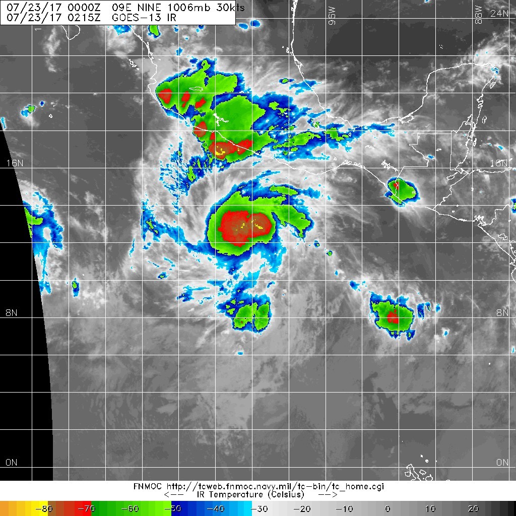
A persistent area of convection has developed near and over the
center of the depression since the last advisory.  In addition, a
recent SSMI/S overpass shows the low- to mid-level convective
banding has become better defined.  Based on this, the initial
intensity is increased to 35 kt, the upper end of the satellite
intensity estimates, and the depression is upgraded to Tropical
Storm Hilary.

Hilary should remain in an environment of light vertical shear and
warm sea surface temperatures for the next 4 days, and thus it
should at least steadily, if not rapidly, strengthen.  After day
4, the cyclone should move over decreasing sea surface temperatures
and into stronger shear, and the new intensity forecast shows
weakening at that time.  The new intensity forecast lies below that
of the SHIPS model and the HCCA corrected consensus, and it is
possible an upward adjustment of the forecast intensities may be
required in later advisories.

The initial motion is 300/12. The main steering feature should be a
mid-level ridge extending from Mexico westward into the Pacific,
and this should steer the cyclone generally west-northwestward
through the forecast period.  Near the end of the period, there is
a possibility of interaction with Tropical Depression Ten-E,
although present indications in the large-scale guidance are this
should have a minimal impact on Hilary's track.  The new forecast
track is similar to, but a little north of, the previous track, and
it lies near the various consensus models.  The new track keeps
the core of the cyclone well south of the coast of Mexico.


FORECAST POSITIONS AND MAX WINDS

INIT  23/0300Z 11.5N 100.2W   35 KT  40 MPH
12H  23/1200Z 12.1N 101.5W   40 KT  45 MPH
24H  24/0000Z 13.0N 103.2W   45 KT  50 MPH
36H  24/1200Z 13.7N 104.6W   55 KT  65 MPH
48H  25/0000Z 14.4N 106.2W   70 KT  80 MPH
72H  26/0000Z 16.0N 110.0W   90 KT 105 MPH
96H  27/0000Z 17.0N 113.5W   95 KT 110 MPH
120H  28/0000Z 18.5N 116.5W   90 KT 105 MPH

$$
Forecaster Beven
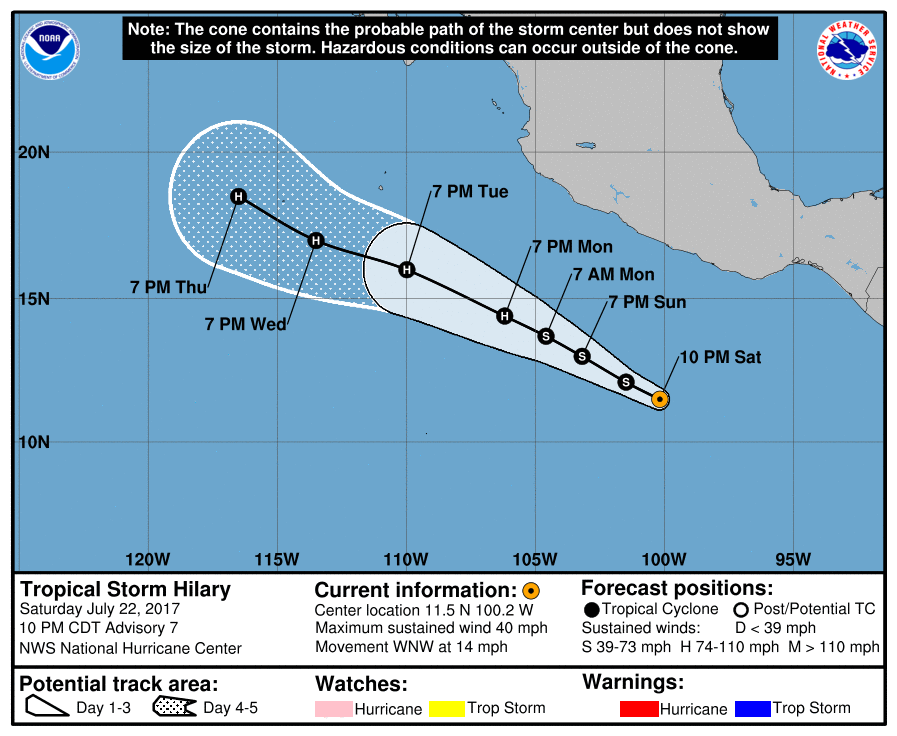
030402_5day_cone_with_line.png

20170723.0215.goes-13.ircolor.09E.NINE.30kts.1006mb.11.2N.99.7W.100pc.jpg
回復

使用道具 舉報

簽到天數: 633 天

[LV.9]以壇為家II

cas98709|2017-7-23 11:36 | 顯示全部樓層
gl_sst_mm.gif
太平洋上一共8旋,不過看來還是東太的品質比較好XD

點評

恩恩~東太已經3個颶風等級..其中一個C4...  發表於 2017-7-23 11:53
回復

使用道具 舉報

簽到天數: 3279 天

[LV.Master]伴壇終老

t02436|2017-7-24 13:22 | 顯示全部樓層
NHC評價60節,指出Hilary已經進入RI階段,兩天後將衝擊巔峰110節。
...HILARY RAPIDLY INTENSIFYING... ...PRIMED TO BECOME A MAJOR HURRICANE BY TUESDAY...
000
WTPZ44 KNHC 240250
TCDEP4

Tropical Storm Hilary Discussion Number  11
NWS National Hurricane Center Miami FL       EP092017
1000 PM CDT Sun Jul 23 2017

Hilary has continued to become better organized with a curved
convective band now wrapping nearly all the way around the
low-level center, and a banding eye of about 10 n mi in diameter
evident in recent SSMI/S microwave satellite data. The intensity
estimate was 55 kt by TAFB at 0000Z, but since the overall
convective and inner-core patterns have improved during the past few
hours, the initial intensity is increased to 60 kt for this
advisory.

The initial motion estimate is 300/08 kt. There is no significant
change to the previous forecast track or reasoning. Hilary is
expected to move west-northwestward along the southern periphery of
a deep-layer ridge to its north for the next several days, with a
slight increase in forward speed expected in about 48 hours or so.
The new model guidance is tightly packed around the previous
NHC advisory track through 96 h, so the new forecast track is just
an update of the previous one, and closely follows the HCCA and
TVCN models.

Given the improving inner-core structure, coupled with very low
vertical shear values and a moist unstable environment, continued
rapid intensification appears likely for the next 36-48 hours while
the small cyclone remains over SSTs greater than 28C. By 72 hours,
SSTs cool to near 27C and the upper-ocean heat content decreases to
less than 10 units, suggesting that cold upwelling will probably
begin around that time. The new intensity forecast follows the
previous advisory by showing rapid strengthening of about 15 kt
every 12 hours for the next 36 hours, followed by a slightly slower
rate of strengthening since an eyewall replacement cycle could begin
in the 36-48 h period. After that, increasing shear and cooler
water temperatures should induce gradual weakening. The official
intensity forecast is similar to the corrected-consensus model HCCA,
which brings Hilary to a 116-kt, category-4 hurricane in 48 hours.

FORECAST POSITIONS AND MAX WINDS

INIT  24/0300Z 13.6N 103.5W   60 KT  70 MPH
12H  24/1200Z 14.0N 104.5W   70 KT  80 MPH
24H  25/0000Z 14.7N 106.0W   85 KT 100 MPH
36H  25/1200Z 15.4N 107.6W  100 KT 115 MPH
48H  26/0000Z 16.1N 109.5W  110 KT 125 MPH
72H  27/0000Z 17.2N 113.4W  105 KT 120 MPH
96H  28/0000Z 18.3N 117.1W   90 KT 105 MPH
120H  29/0000Z 19.2N 120.8W   80 KT  90 MPH

$$
Forecaster Stewart

025517_5day_cone_with_line.png

rbtop-animated.gif
回復

使用道具 舉報

簽到天數: 3279 天

[LV.Master]伴壇終老

t02436|2017-7-31 00:52 | 顯示全部樓層
剩下空殼,大概是熱帶風暴的最後一報了吧...
ZCZC MIATCDEP4 ALL
TTAA00 KNHC DDHHMM

Tropical Storm Hilary Discussion Number  37
NWS National Hurricane Center Miami FL       EP092017
800 AM PDT Sun Jul 30 2017

Convection has continued to rapidly wane with only a small band of
modest thunderstorm activity with tops to -30C restricted to the
southeastern quadrant. The initial intensity has been lowered to 35
kt based on a blend of available intensity estimates from TAFB, SAB,
and UW-CIMSS ADT and SATCON. This rapid weakening trend is forecast
to continue since Hilary is now moving over sub-22 C SSTs and into
an extensive field of stable, cold-air stratocumulus clouds. These
unfavorable thermodynamic conditions should cause Hilary to
degenerate into a remnant low pressure system tonight, if not
sooner.

The initial motion estimate is 300/11 kt. As Hilary continues to
lose its deep vertical circulation, the shallow cyclone should
maintain a general west-northwestward motion along the southern
periphery of a deep-layer ridge until dissipation occurs in 72 h.
The NHC track forecast remains along the southern portion of the
tightly clustered guidance and is close to the previous advisory
track.

FORECAST POSITIONS AND MAX WINDS

INIT  30/1500Z 23.9N 125.7W   35 KT  40 MPH
12H  31/0000Z 24.9N 127.7W   30 KT  35 MPH
24H  31/1200Z 25.8N 129.9W   25 KT  30 MPH...POST-TROP/REMNT LOW
36H  01/0000Z 26.3N 131.7W   20 KT  25 MPH...POST-TROP/REMNT LOW
48H  01/1200Z 26.7N 133.2W   15 KT  15 MPH...POST-TROP/REMNT LOW
72H  02/1200Z...DISSIPATED

$$
Forecaster Stewart

NNNN

143940_5day_cone_with_line_and_wind.png

rbtop-animated.gif
回復

使用道具 舉報

快速回覆
您需要登錄後才可以回帖 登錄 | 立即加入

本版積分規則

劉瑞益@FB

    主題

    帖子

    104萬

    積分

    13級[一級颶風]

    Rank: 13Rank: 13Rank: 13Rank: 13

13級[一級颶風]

發訊息

本平台僅供學術討論之用,預報應以氣象局為準

威普網站虛擬主機贊助公司

臺灣第一個天氣類型社群平台 即時天氣資訊、精準颱風動態

線上客服
FB傳送訊息
廣告行銷
精準行銷 物超所值
官方粉專
發佈 快速回復 返回頂部 返回列表