開啟輔助訪問
 找回密碼
 立即加入

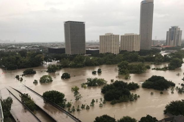
09L.Harvey 二次登陸 德州雨量破紀錄

簽到天數: 582 天

[LV.9]以壇為家II

蜜露|2017-8-28 00:19 | 顯示全部樓層
本帖最後由 蜜露 於 2017-8-28 20:39 編輯


_97559879_mediaitem97559878.jpg


5184.jpg
43971D1000000578-4825124-image-a-192_1503782116611.jpg

bandicam 2017-08-28 00-17-40-501.jpg


2346880_1280x720.jpg


bandicam 2017-08-27 23-54-18-439.jpg


2017-08-26t23-02-25-9z--1280x720.nbcnews-ux-1080-600.jpg


這次颶風帶來德克薩斯州5分之1的地方災到風毀.

主要是風災為主.

從德州的聖體市、喬治、辛頓的災情慘重.
幾乎都是屋簷被吹走 .

可說是2004年查理颶風後,登陸美國本土大陸威力最強的颶風 .

近岸增強四級颶風而登陸 , 在亞洲類似的近岸增強+強度曾發生在2015年彩虹颱風 、蘇迪勒颱風 、2016年梅姬颱風身上 .
(中颱上限的颱風等級)


點評

風災只是開始,更恐怖的史詩級洪災正在蔓延。  發表於 2017-8-28 03:19
回復

使用道具 舉報

簽到天數: 601 天

[LV.9]以壇為家II

霧峰追風者|2017-8-28 06:46 | 顯示全部樓層
有機會打轉出海後,強度在略為提高,並2次登陸德州。
000
WTNT44 KNHC 272046
TCDAT4

Tropical Storm Harvey Discussion Number  30
NWS National Hurricane Center Miami FL       AL092017
400 PM CDT Sun Aug 27 2017

The unprecedented flooding rainfall event continues to unfold over a
large area of southeastern Texas.  While Harvey has been moving
slowly eastward or east-southeastward today, bands of heavy rainfall
have continued to form over the northwestern Gulf and train inland
over much of the upper Texas coast and southwestern Louisiana. Storm
total rainfall amounts in the 20-27 inch range are quite common in
the Greater Houston area, and additional rainfall amounts of 15 to
25 inches are expected over the next several days.  Rainfall total
could reach 50 inches in some locations, which would be historic
for that area.

Harvey is still producing tropical-storm-force winds, with a recent
observation of 34 kt with a gust to 46 kt at New Braunfels, Texas.
The NHC track guidance is in better agreement showing Harvey moving
just offshore of the Texas coast on Monday, then turning northward
and moving inland over northeastern Texas by 72 hours.  All of the
global models show some slight deepening of the system after it
moves over water, but given the lack of an inner core, significant
strengthening is not anticipated.  Although a tropical storm watch
has been issued, which may need to be extended eastward along
the upper Texas and southwest Louisiana coast tonight, heavy
rainfall and life-threatening flooding continue to the primary
threats.

Key Messages:

1. Ongoing catastrophic and life-threatening flooding will continue
across southeastern Texas.  Additional rainfall accumulations of 15
to 25 inches are expected, with isolated storm totals as high as 50
inches, through Friday.  Please heed the advice of local officials.
Do not attempt to travel if you are in a safe place, and do not
drive into flooded roadways.  Refer to products from your local
National Weather Service office and the NOAA Weather Prediction
Center for more information on the flooding hazard.  A summary of
rainfall totals compiled by the Weather Prediction Center can be
found at: www.wpc.ncep.noaa.gov/discussions/nfdscc1.html

FORECAST POSITIONS AND MAX WINDS

INIT  27/2100Z 29.0N  97.0W   35 KT  40 MPH...INLAND
12H  28/0600Z 28.7N  96.8W   35 KT  40 MPH...INLAND
24H  28/1800Z 28.4N  96.4W   35 KT  40 MPH...NEAR THE COAST
36H  29/0600Z 28.2N  96.0W   40 KT  45 MPH...OVER WATER
48H  29/1800Z 28.4N  95.6W   40 KT  45 MPH...OVER WATER
72H  30/1800Z 29.9N  95.2W   35 KT  40 MPH...INLAND
96H  31/1800Z 31.8N  94.7W   30 KT  35 MPH...INLAND
120H  01/1800Z 33.5N  93.4W   25 KT  30 MPH...INLAND

$$
Forecaster Brown
212746_5day_cone_no_line_and_wind.png rgb-animated (9).gif


回復

使用道具 舉報

該用戶從未簽到

cheny|2017-8-28 07:54 來自手機 | 顯示全部樓層
一天600公厘的降雨,對德州已是前無古人、後無來者的記錄,更何況預測累積雨量將達1200公厘,將毀滅休士頓。
回復

使用道具 舉報

簽到天數: 1988 天

[LV.Master]伴壇終老

ben811018|2017-8-28 13:37 | 顯示全部樓層
螢幕擷取畫面 (495).png

存圖~
回復

使用道具 舉報

簽到天數: 601 天

[LV.9]以壇為家II

霧峰追風者|2017-8-29 10:29 | 顯示全部樓層
本帖最後由 霧峰追風者 於 2017-8-29 10:38 編輯

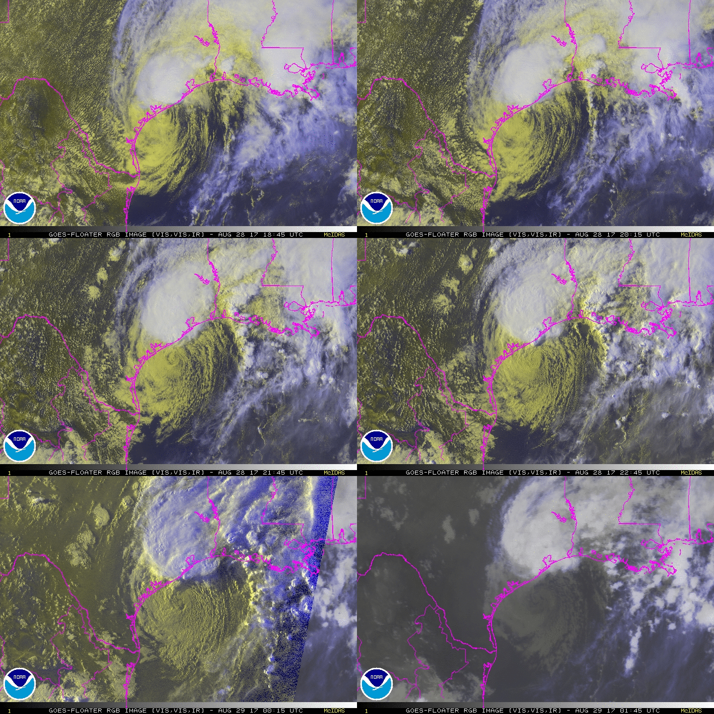
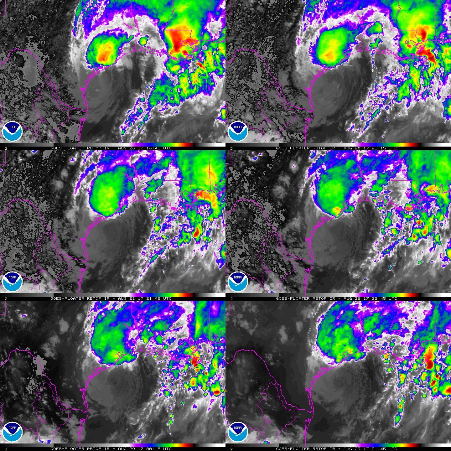
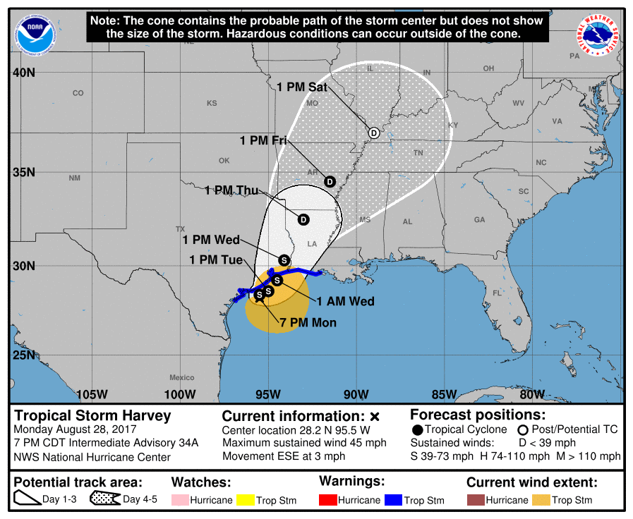
稍早中心已經出海了,強度略為增強至40kts,預計明天再次登陸德州。
ZCZC MIATCDAT4 ALL
TTAA00 KNHC DDHHMM CCA

Tropical Storm Harvey Discussion Number  34...Corrected
NWS National Hurricane Center Miami FL       AL092017
400 PM CDT Mon Aug 28 2017

Corrected initial intensity in first paragraph

Radar and surface data show that the center of Harvey remains near
or just off the Texas coast south of Matagorda.  The associated
convection has increased in intensity and coverage in a cluster
extending from just north of the center northeastward into the
Houston metropolitan area.  Surface observations indicate that the
central pressure is around 997 mb, and there are recent reports of
sustained tropical-storm-force winds about 50-60 n mi southwest of
the center.  Based on these, the initial intensity is increased to
40 kt.

Very heavy rains and life-threatening flash flooding continue over
southeastern Texas and southwestern Louisiana.  There have been
reports of 2-day rainfall totals of close to 35 inches in the
Greater Houston area.  With the additional rains that are expected
over the next several days, rainfall totals could reach 50 inches in
some locations, which would be historic for the area.

While Harvey continues to produce widespread heavy rain, the
convective structure is not well organized in terms of being a
tropical cyclone.  In addition, a dry slot is seen in water vapor
imagery over the southern and southeastern parts of the circulation,
and the intensity guidance is not showing much additional
development as Harvey crosses the northwestern Gulf of Mexico.  The
intensity forecast reflects these issues by showing little change
in strength before landfall.  Weakening and eventual decay into a
remnant low are expected after landfall.

The center has drifted erratically eastward since the last
advisory, although a longer-term motion is 110/3.  Harvey is
currently between the subtropical ridge over the Gulf of Mexico and
a large deep-layer ridge over the western United States, with a
large trough in the westerlies weakening the Gulf ridge just enough
to allow an east-southeastward motion.  The large-scale models
suggest that the westerlies should erode the western ridge to some
extent during the forecast period, which should allow Harvey to
turn north-northeastward under the greater influence of the Gulf
ridge.  The track guidance has changed little since the previous
advisory except to show a faster motion from 96-120 h.  The new
forecast track remains close to that of the previous track, except
for an increased forward speed by 120 h.


Key Messages:

1. Ongoing catastrophic and life-threatening flooding will continue
across southeastern Texas.  Additional rainfall accumulations of 15
to 25 inches are expected across the upper Texas coast, with
isolated storm totals as high as 50 inches.  Please heed the advice
of local officials.  Do not attempt to travel if you are in a safe
place, and do not drive into flooded roadways.  Refer to products
from your local National Weather Service office and the NOAA Weather
Prediction Center for more information on the flooding hazard.  A
summary of rainfall totals compiled by the Weather Prediction Center
can be found at: www.wpc.ncep.noaa.gov/discussions/nfdscc1.html

2. The flood threat is spreading farther east into Louisiana.
Additional rainfall amounts of 15 to 25 inches are expected in
southwestern Louisiana, with rainfall amounts of 5 to 15 inches
expected in south-central Louisiana and 5 to 10 inches in
southeastern Louisiana. Please heed the advice of local officials
and refer to products from your local National Weather Service
office and the NOAA Weather Prediction Center for more information
on the flooding hazard in these areas.

3. While Tropical Storm Warnings have been extended eastward along
the coast of Louisiana and a Storm Surge Watch has been issued, the
impacts of winds and storm surge are expected to be secondary
compared to that of the rains.


FORECAST POSITIONS AND MAX WINDS

INIT  28/2100Z 28.5N  95.7W   40 KT  45 MPH
12H  29/0600Z 28.4N  95.5W   40 KT  45 MPH
24H  29/1800Z 28.6N  95.0W   40 KT  45 MPH
36H  30/0600Z 29.2N  94.5W   40 KT  45 MPH
48H  30/1800Z 30.3N  94.1W   35 KT  40 MPH...INLAND
72H  31/1800Z 32.5N  93.0W   30 KT  35 MPH...INLAND
96H  01/1800Z 34.5N  91.5W   25 KT  30 MPH...INLAND
120H  02/1800Z 37.0N  89.0W   20 KT  25 MPH...POST-TROP/INLAND

$$
Forecaster Beven

NNNN
211730_5day_cone_no_line_and_wind.png rgb-animated (10).gif rbtop-animated (15).gif
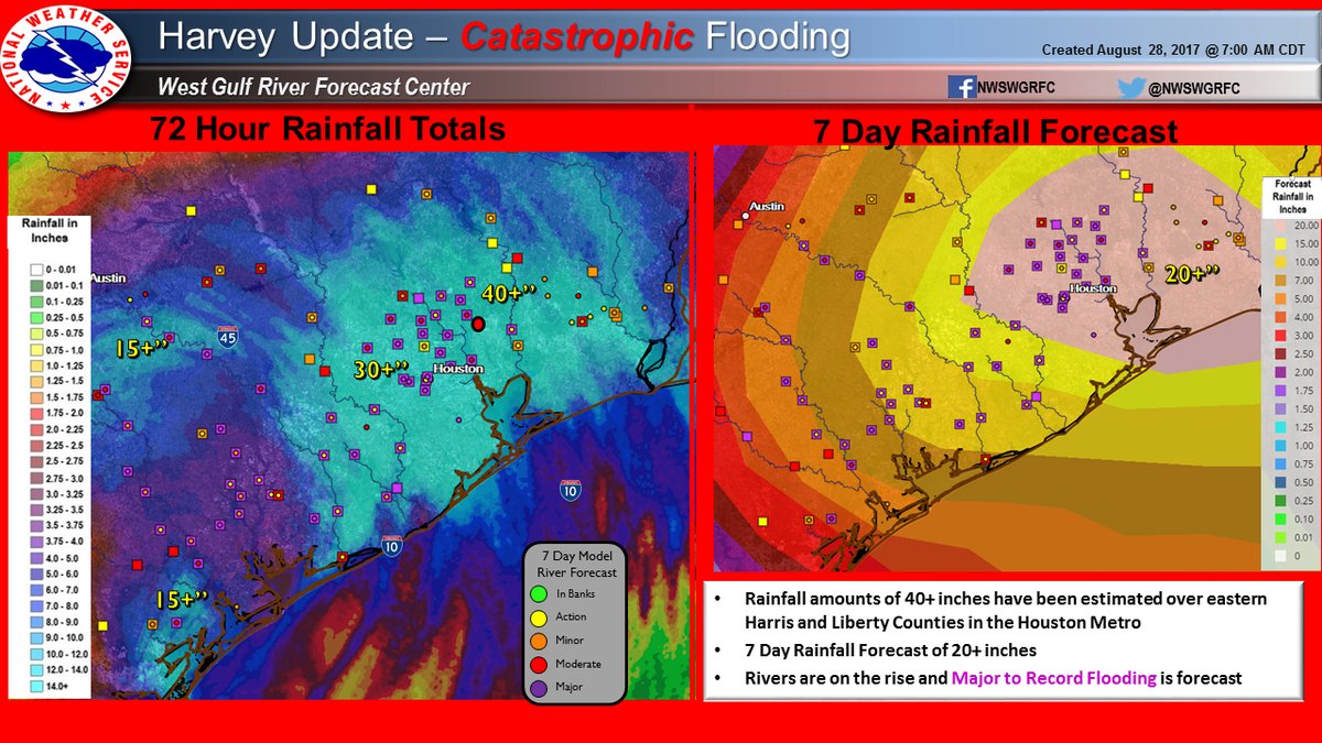
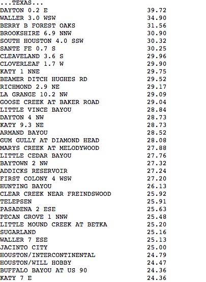
幾天下來的雨量與淹水災情。 德州雨量累積.jpg 德州雨量累積-1.jpg 德州淹水.jpg 德州安養院淹水.jpg

點評

都泡到髒水裡... 要是我早就發瘋了  發表於 2017-8-29 11:24
這路徑...真是有夠難纏 倒了霉...德州  發表於 2017-8-29 11:13
回復

使用道具 舉報

簽到天數: 582 天

[LV.9]以壇為家II

蜜露|2017-8-29 19:49 | 顯示全部樓層
本帖最後由 蜜露 於 2017-8-29 19:52 編輯


hurricane-harvey-texas-submerged-car-flooding-rain-ap17240036753547.jpg

下載.jpg
920x920 (1).jpg


這次颶風登陸後 , 一開始是風災 .  彷彿梅姬般 .

之後速度減慢 , 影響德克薩斯州範圍從原本的風災 5分之1 ,
加上水災後變成5分之3 .  變成梅姬的風+納莉的雨

聖體市 維多利亞 辛頓 哥倫布 舒格蘭 休士頓 都是影響範圍喔


點評

這水淹成這樣真的WTF......  詳情 回復 發表於 2017-8-29 21:34
回復

使用道具 舉報

該用戶從未簽到

Kujira|2017-8-29 21:34 來自手機 | 顯示全部樓層
蜜露 發表於 2017-8-29 19:49
這次颶風登陸後 , 一開始是風災 .  彷彿梅姬般 .

之後速度減慢 , 影響德克薩斯州範圍從原本的風災  ...

這水淹成這樣真的WTF......
回復

使用道具 舉報

簽到天數: 588 天

[LV.9]以壇為家II

Meow|2017-8-30 01:35 | 顯示全部樓層
水庫潰壩⋯⋯降水破美國歷史紀錄⋯⋯
螢幕快照 2017-08-30 01.23.50.png
https://twitter.com/BrazoriaCounty/status/902539081841827842
21151499_1510527722340594_388972823004501468_n.png

評分

參與人數 2水氣能量 +8 收起 理由
b997755 + 3 淹的好扯
t02436 + 5

查看全部評分

回復

使用道具 舉報

快速回覆
您需要登錄後才可以回帖 登錄 | 立即加入

本版積分規則

本平台僅供學術討論之用,預報應以氣象局為準

威普網站虛擬主機贊助公司

臺灣第一個天氣類型社群平台 即時天氣資訊、精準颱風動態

線上客服
FB傳送訊息
廣告行銷
精準行銷 物超所值
官方粉專
發佈 快速回復 返回頂部 返回列表