開啟輔助訪問
 找回密碼
 立即加入

11L.Irma 橫颳大西洋 逐漸消亡

簽到天數: 3279 天

[LV.Master]伴壇終老

t02436|2017-9-9 23:28 | 顯示全部樓層
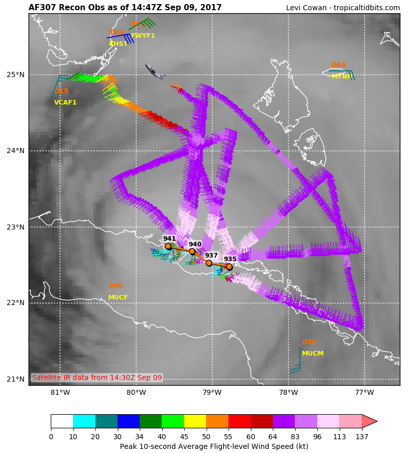
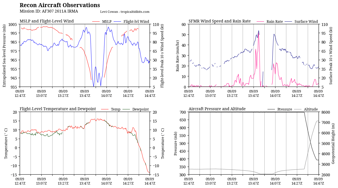
古巴陸地對系統影響仍舊存在,15Z根據實測調弱到C3,16Z將開始進行每小時定位,登陸點調西到佛州西部,預期登陸前還有小幅增強空間。
000
WTNT41 KNHC 091458
TCDAT1

Hurricane Irma Discussion Number  42
NWS National Hurricane Center Miami FL       AL112017
1100 AM EDT Sat Sep 09 2017

The interaction of Irma's circulation with Cuba has resulted in
some weakening of the hurricane.  Data from an Air Force plane
indicate that the maximum winds are now 110 kt.  However, once the
circulation moves away from Cuba, restrengthening is forecast and
Irma is expected to remain a very dangerous hurricane for the next 2
days while moving very near the Florida peninsula.

The eye has been moving toward the west or 280 degrees at about 8
kt.  The hurricane is about the reach the southwestern portion of
the subtropical high, and the expected  turn to the northwest and
north-northwest should begin soon.  The track guidance is tightly
packed and takes the hurricane over the Florida Keys and near or
over the Florida Peninsula. The NHC forecast is in the middle of
the guidance envelope and given the good agreement among models, the
confidence in the track forecast is high.

Irma is now under the scope of Key West radar, so hourly updates
will begin at 1600 UTC.


KEY MESSAGES:

1. Irma will continue to bring life-threatening wind, storm surge,
and rainfall hazards to portions of the Bahamas and the north coast
of Cuba, especially over the adjacent Cuban Keys, through tonight.

2. Irma is expected to make landfall in Florida as an extremely
dangerous major hurricane, bringing life-threatening wind
impacts to much of the state regardless of the exact track of the
center. Wind hazards from Irma are also expected to spread northward
along the coast of Georgia and South Carolina where a Hurricane
Watch has been issued.

3. There is an imminent danger of life-threatening storm surge
flooding in portions of central and southern Florida, including the
Florida Keys, where a Storm Surge Warning is in effect. The threat
of catastrophic storm surge flooding is highest along the southwest
coast of Florida, where 10 to 15 feet of inundation above ground
level is expected. This is a life-threatening situation and everyone
in these areas should immediately follow any evacuation instructions
from local officials.

4. Irma is expected to produce very heavy rain and inland flooding.
Total rain accumulations of 10 to 20 inches, with isolated amounts
of between 20 and 25 inches, are expected over the Florida Keys, the
Florida peninsula, and southeast Georgia from Saturday through
Monday. Significant river flooding is possible in these areas. Early
next week Irma will also bring periods of heavy rain to much of the
southeast United States where an average of 2 to 6 inches is
forecast, with isolated higher amounts, from North and South
Carolina to Tennessee and eastern Alabama. This includes some
mountainous areas which are more prone to flash flooding.  Residents
throughout the southeast states should remain aware of the flood
threat and stay tuned to forecasts and warnings.


FORECAST POSITIONS AND MAX WINDS

INIT  09/1500Z 22.8N  79.8W  110 KT 125 MPH
12H  10/0000Z 23.4N  80.7W  115 KT 130 MPH
24H  10/1200Z 24.5N  81.6W  120 KT 140 MPH
36H  11/0000Z 26.4N  82.1W  120 KT 140 MPH
48H  11/1200Z 29.0N  82.8W  100 KT 115 MPH
72H  12/1200Z 34.5N  86.0W   25 KT  30 MPH...POST-TROP/INLAND
96H  13/1200Z 36.0N  89.0W   25 KT  30 MPH...POST-TROP/INLAND
120H  14/1200Z 37.0N  88.5W   20 KT  25 MPH...POST-TROP/INLAND

$$
Forecaster Avila
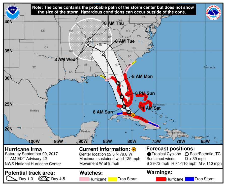
095407_5day_cone_with_line.png

recon_AF307-2611A-IRMA.png

recon_AF307-2611A-IRMA_timeseries.png

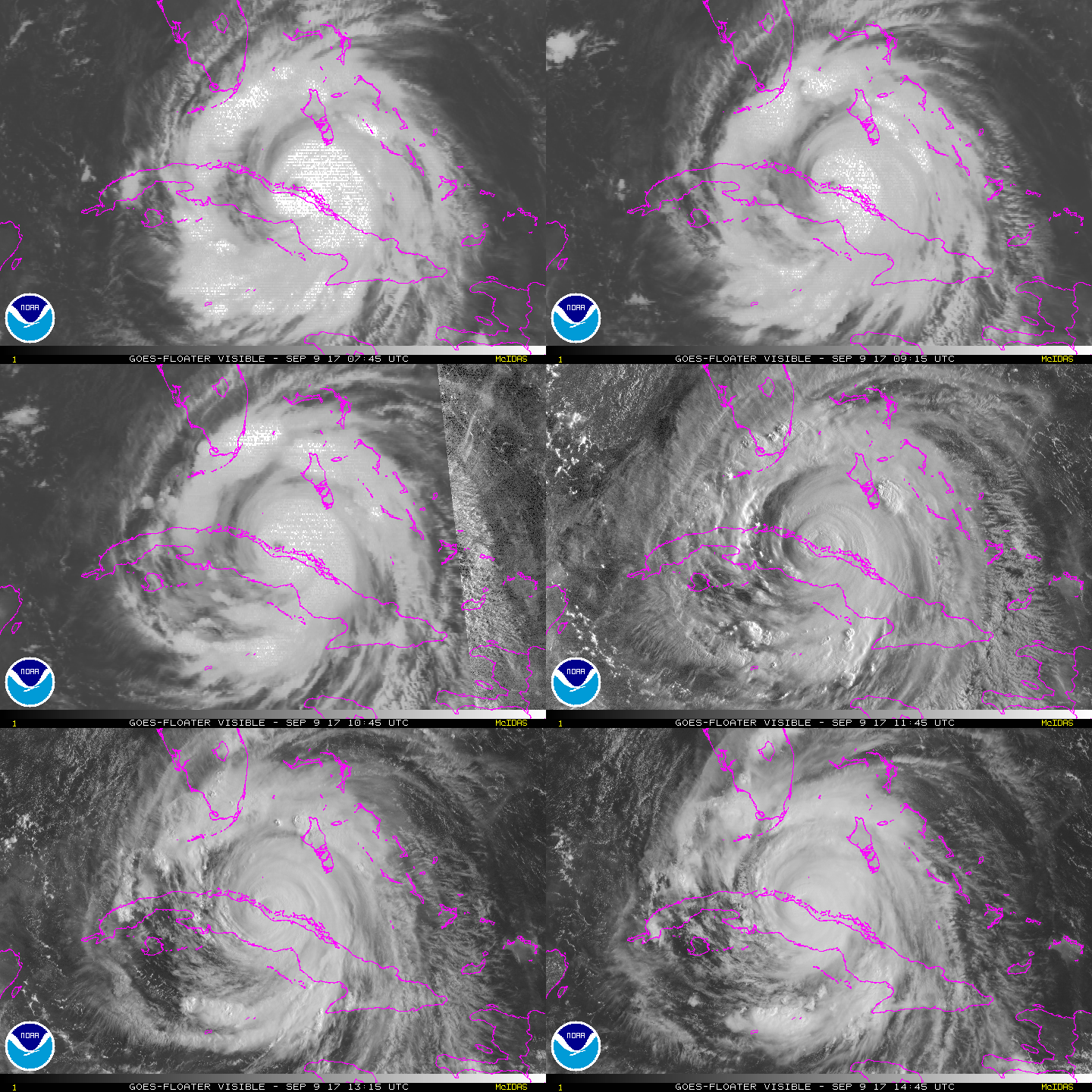
vis-animated.gif
回復

使用道具 舉報

簽到天數: 3279 天

[LV.Master]伴壇終老

t02436|2017-9-10 01:46 | 顯示全部樓層
古巴謝戈德阿維拉省錄得71m/s陣風....
000
WTNT61 KNHC 091724 CCA
TCUAT1

Hurricane Irma Tropical Cyclone Update...Corrected
NWS National Hurricane Center Miami FL       AL112017
100 PM EDT Sat Sep 09 2017

Corrected format of summary section

...100 PM EDT POSITION UPDATE...
...IRMA MOVING NEAR THE NORTH COAST OF CUBA ...

Earlier today there was a report from a weather station in Ciego
de Avila, Cuba, of a wind gust to 159 mph (256 km/h).


SUMMARY OF 100 PM EDT...1700 UTC...INFORMATION
----------------------------------------------
LOCATION...23.0N 80.0W
ABOUT 75 MI...125 KM E OF VARADERO CUBA
ABOUT 160 MI...255 KM SE OF KEY WEST FLORIDA
MAXIMUM SUSTAINED WINDS...125 MPH...205 KM/H
PRESENT MOVEMENT...W OR 280 DEGREES AT 9 MPH...15 KM/H
MINIMUM CENTRAL PRESSURE...941 MB...27.79 INCHES

$$
Forecaster Pasch/Mello/Brennan

NacComp200Km.gif

20170909.1626.gpm.89pct89h89v.11L.IRMA.115kts.941mb.22.7N.79.3W.055pc.jpg

LATEST.jpg

20170909.1715.goes-13.ircolor.11L.IRMA.115kts.941mb.22.7N.79.3W.100pc.jpg

點評

從登陸Miami改成Tampa, 這也差太多了吧?  發表於 2017-9-10 09:59

評分

參與人數 1水氣能量 +3 收起 理由
b997755 + 3 經過兩次置換,風場果然又擴大了,超過250k.

查看全部評分

回復

使用道具 舉報

簽到天數: 3279 天

[LV.Master]伴壇終老

t02436|2017-9-10 14:05 | 顯示全部樓層
開始增強,06Z重回C4!
BULLETIN
Hurricane Irma Intermediate Advisory Number 44A
NWS National Hurricane Center Miami FL       AL112017
200 AM EDT Sun Sep 10 2017

...IRMA NOW A CATEGORY 4 HURRICANE AS IT GETS CLOSER TO THE LOWER
FLORIDA KEYS...


SUMMARY OF 200 AM EDT...0600 UTC...INFORMATION
----------------------------------------------
LOCATION...23.7N 81.3W
ABOUT 40 MI...65 KM N OF VARADERO CUBA
ABOUT 70 MI...115 KM SSE OF KEY WEST FLORIDA
MAXIMUM SUSTAINED WINDS...130 MPH...210 KM/H
PRESENT MOVEMENT...NW OR 310 DEGREES AT 6 MPH...9 KM/H
MINIMUM CENTRAL PRESSURE...931 MB...27.49 INCHES

034247_5day_cone_with_line.png

GOES05572017253HLq8JG.jpg

National Weather Service Enhanced Radar Image.png

20170909.2346.f18.91pct91h91v.11L.IRMA.110kts.938mb.23.1N.80.2W.075pc.jpg

recon_AF302-2911A-IRMA.png

recon_AF302-2911A-IRMA_timeseries.png

Irma_9-10Sep17_BYX.gif
回復

使用道具 舉報

簽到天數: 582 天

[LV.9]以壇為家II

蜜露|2017-9-10 21:23 | 顯示全部樓層


重回Cat.4後 第一次實測是926hPa

第二次是930左右

recon_AF306-3011A-IRMA_timeseries.png

Cat.4的最下層 115Kts強度

雖然好不容易脫離了古巴 , 海溫和OHC很高

bandicam 2017-09-10 21-17-21-916.jpg

但相對風切也很強 . 恐怕是這次艾瑪中止在增強的原因.

wg8sht.GIF


點評

這風切肯定比泰利的環境還高呀,都25KTS了,會破壞水平結構  發表於 2017-9-10 23:10
這風切還是比西太友善許多,泰利現在都處在負的環境  發表於 2017-9-10 21:34
回復

使用道具 舉報

簽到天數: 588 天

[LV.9]以壇為家II

Meow|2017-9-10 21:30 | 顯示全部樓層
1310Z登陸佛羅里達州

ZCZC MIATCUAT1 ALL
TTAA00 KNHC DDHHMM

Hurricane Irma Tropical Cyclone Update
NWS National Hurricane Center Miami FL       AL112017
910 AM EDT Sun Sep 10 2017

...IRMA MAKES LANDFALL AT CUDJOE KEY IN LOWER FLORIDA KEYS...

The center of Hurricane Irma made landfall at Cudjoe Key in the
lower Florida Keys at 9:10 am EDT.  A gust to 106 mph (171 km/h)
was just reported at the National Key Deer Refuge in Big Pine Key.

SUMMARY OF 910 AM EDT...1310 UTC...INFORMATION
----------------------------------------------
LOCATION...24.7N 81.5W
ABOUT 20 MI...30 KM ENE OF KEY WEST FLORIDA
MAXIMUM SUSTAINED WINDS...130 MPH...215 KM/H
PRESENT MOVEMENT...NNW OR 330 DEGREES AT 8 MPH...13 KM/H
MINIMUM CENTRAL PRESSURE...929 MB...27.43 INCHES

$$
Forecaster Landsea/Mello

NNNN

點評

離題一下 剛剛看了Yuotube新聞直播 下面流言的都說是是Fake News跟Fake Hurricane...不知道該說什麼  詳情 回復 發表於 2017-9-10 22:33
回復

使用道具 舉報

簽到天數: 12 天

[LV.3]偶爾看看II

儒比比|2017-9-10 22:33 來自手機 | 顯示全部樓層
Meow 發表於 2017-9-10 21:30
1310Z登陸佛羅里達州

ZCZC MIATCUAT1 ALL

離題一下 剛剛看了Yuotube新聞直播 下面流言的都說是是Fake News跟Fake Hurricane...不知道該說什麼

點評

總統的朋友?可能吧。 但應該唔似是假新聞。  詳情 回復 發表於 2017-9-10 23:53
回復

使用道具 舉報

簽到天數: 166 天

[LV.7]常住居民III

Alexchow|2017-9-10 23:53 來自手機 | 顯示全部樓層
儒比比 發表於 2017-9-10 22:33
離題一下 剛剛看了Yuotube新聞直播 下面流言的都說是是Fake News跟Fake Hurricane...不知道該說什麼 ...

總統的朋友?可能吧。

但應該唔似是假新聞。
回復

使用道具 舉報

簽到天數: 3279 天

[LV.Master]伴壇終老

t02436|2017-9-11 01:05 | 顯示全部樓層
中心穩定北上,準備登陸,登陸點大概就落在馬可島了。
ZCZC MIATCUAT1 ALL
TTAA00 KNHC DDHHMM

Hurricane Irma Tropical Cyclone Update
NWS National Hurricane Center Miami FL       AL112017
100 PM EDT Sun Sep 10 2017

...100 PM EDT POSITION UPDATE...
...IRMA IMPACTING ALL OF SOUTH FLORIDA...

A 77 mph (124 km/h) sustained wind and a 92 mph (148 km/h) gust
have been recently reported at the National Data Buoy Center C-MAN
station at Fowey Rock.  A 92 mph (148 km/h) wind gust has been
recently reported at the Federal Aviation Administration station at
Miami International Airport.

SUMMARY OF 100 PM EDT...1700 UTC...INFORMATION
----------------------------------------------
LOCATION...25.4N 81.7W
ABOUT 50 MI...80 KM S OF NAPLES FLORIDA
MAXIMUM SUSTAINED WINDS...130 MPH...215 KM/H
PRESENT MOVEMENT...N OR 350 DEGREES AT 9 MPH...15 KM/H
MINIMUM CENTRAL PRESSURE...933 MB...27.55 INCHES

$$
Forecaster Landsea/Mello

NNNN

152748_5day_cone_with_line.png

National Weather Service Enhanced Radar Image.png

GOES16552017253vJp9c2.jpg

recon_AF306-3011A-IRMA.png

rbtop-animated.gif
回復

使用道具 舉報

快速回覆
您需要登錄後才可以回帖 登錄 | 立即加入

本版積分規則

本平台僅供學術討論之用,預報應以氣象局為準

威普網站虛擬主機贊助公司

臺灣第一個天氣類型社群平台 即時天氣資訊、精準颱風動態

線上客服
FB傳送訊息
廣告行銷
精準行銷 物超所值
官方粉專
發佈 快速回復 返回頂部 返回列表