開啟輔助訪問
 找回密碼
 立即加入

21S.Veronica 登陸前轉向 沿西澳西北部近海西行

簽到天數: 601 天

[LV.9]以壇為家II

霧峰追風者|2019-3-21 10:01 | 顯示全部樓層
BoM 00Z強度同樣升澳式C4,巔峰上望澳式C5。
IDW27600
TROPICAL CYCLONE TECHNICAL BULLETIN: AUSTRALIA - WESTERN REGION
Issued by PERTH TROPICAL CYCLONE WARNING CENTRE
at: 0124 UTC 21/03/2019
Name: Severe Tropical Cyclone Veronica
Identifier: 19U
Data At: 0000 UTC
Latitude: 16.4S
Longitude: 117.7E
Location Accuracy: within 15 nm [30 km]
Movement Towards: south [169 deg]
Speed of Movement: 5 knots [9 km/h]
Maximum 10-Minute Wind: 100 knots [185 km/h]
Maximum 3-Second Wind Gust: 140 knots [260 km/h]
Central Pressure: 944 hPa
Radius of 34-knot winds NE quadrant: 100 nm [185 km]
Radius of 34-knot winds SE quadrant: 100 nm [185 km]
Radius of 34-knot winds SW quadrant: 100 nm [185 km]
Radius of 34-knot winds NW quadrant: 100 nm [185 km]
Radius of 48-knot winds NE quadrant: 50 nm [95 km]
Radius of 48-knot winds SE quadrant: 50 nm [95 km]
Radius of 48-knot winds SW quadrant: 50 nm [95 km]
Radius of 48-knot winds NW quadrant: 50 nm [95 km]
Radius of 64-knot winds: 30 nm [55 km]
Radius of Maximum Winds: 15 nm [30 km]
Dvorak Intensity Code: T6.0/6.0/D3.0/24HRS STT:D0.5/06HRS
Pressure of outermost isobar: 1004 hPa
Radius of outermost closed isobar: 180 nm [335 km]
FORECAST DATA
Date/Time    : Location    : Loc. Accuracy: Max Wind   : Central Pressure
[UTC]        : degrees     :      nm  [km]: knots[km/h]: hPa
+06:  21/0600: 16.8S 117.5E:     025 [050]:  110  [205]:  933
+12:  21/1200: 17.2S 117.3E:     040 [070]:  110  [205]:  933
+18:  21/1800: 17.4S 117.1E:     050 [095]:  110  [205]:  932
+24:  22/0000: 17.6S 116.9E:     065 [120]:  110  [205]:  932
+36:  22/1200: 18.2S 116.7E:     085 [155]:  110  [205]:  931
+48:  23/0000: 18.8S 116.9E:     105 [190]:  110  [205]:  931
+60:  23/1200: 19.7S 117.3E:     120 [225]:  110  [205]:  931
+72:  24/0000: 20.4S 117.8E:     140 [265]:  100  [185]:  940
+96:  25/0000: 21.0S 118.0E:     185 [345]:  055  [100]:  978
+120: 26/0000: 21.7S 117.0E:     275 [505]:  030  [055]:  998
REMARKS:
Severe TC Veronica has rapidly intensified overnight developing a well defined
eye overnight.

Intensity estimate is 100 kn [category 4]. Dvorak analysis: FT/CI=6.0. This
breaks the intensity constraint by increasing more than 2.5 in 24h but still
short of recent DT of 6.5-7.0 based on eye pattern; Adjusted MET is 5.0 on a
strong D+ trend. CIMSS/NESDIS ADT CI has risen rapidly to [raw 5.9] and SATCON
is lagging at 85kn [10min] but is likely to increase rapidly soon.

The environmental conditions are favourable as is evident by the rapid
intensification over the last 24 hours. Strong poleward and equatorward upper
level outflow, low wind shear, abundant amount of moisture and SSTS of over 30C.


The forecast intensity may fluctuate [cat4-5] in the next 48h owing to inner
core variations. Prior to landfall upper level winds become unfavourable so some
weakening is forecast but this depends on the track and how resilient the
circulation is to the change in upper winds.  

The motion is currently to the south although a resumption to a more south
southwest or southwest track is indicated by all the model guidance within 12
hours. An upper trough may assist in south to southeastward motion towards the
Pilbara coast on Saturday. The cyclone is expected to be moving slowly as it
approaches the coast making a prediction of landfall timing difficult - as early
as overnight Saturday-Sunday or as late as Monday. Some guidance indicates a
subsequent track to the west near the coast. This could result in the cyclone
remaining near or just offshore the west Pilbara coast for a couple days early
next week.

Tides will be close to the highest astronomical tide over the weekend
exacerbating the risk of a significant storm tide impact, but will depend upon
the landfall timing. The slow motion also means that rainfall totals will be
higher than for normal cyclone rainfall levels and totals in excess of 500mm are
possible.


Copyright Commonwealth of Australia
==
The next bulletin for this system will be issued by: 21/0730 UTC by Perth TCWC.

IDW60280.png Screenshot_2019-03-21-09-57-56_com.android.chrome_1553133491682.jpg bd_lalo-animated (2).gif

回復

使用道具 舉報

簽到天數: 1650 天

[LV.Master]伴壇終老

老農民版夜神月|2019-3-21 10:04 | 顯示全部樓層
本帖最後由 老農民版夜神月 於 2019-3-21 12:20 編輯

BoM2100Z定強亦達100KT,並預測六小時內增強至澳式C5

IDW27600
TROPICAL CYCLONE TECHNICAL BULLETIN: AUSTRALIA - WESTERN REGION
Issued by PERTH TROPICAL CYCLONE WARNING CENTRE
at: 0124 UTC 21/03/2019
Name: Severe Tropical Cyclone Veronica
Identifier: 19U
Data At: 0000 UTC
Latitude: 16.4S
Longitude: 117.7E
Location Accuracy: within 15 nm [30 km]
Movement Towards: south [169 deg]
Speed of Movement: 5 knots [9 km/h]
Maximum 10-Minute Wind: 100 knots [185 km/h]
Maximum 3-Second Wind Gust: 140 knots [260 km/h]
Central Pressure: 944 hPa
Radius of 34-knot winds NE quadrant: 100 nm [185 km]
Radius of 34-knot winds SE quadrant: 100 nm [185 km]
Radius of 34-knot winds SW quadrant: 100 nm [185 km]
Radius of 34-knot winds NW quadrant: 100 nm [185 km]
Radius of 48-knot winds NE quadrant: 50 nm [95 km]
Radius of 48-knot winds SE quadrant: 50 nm [95 km]
Radius of 48-knot winds SW quadrant: 50 nm [95 km]
Radius of 48-knot winds NW quadrant: 50 nm [95 km]
Radius of 64-knot winds: 30 nm [55 km]
Radius of Maximum Winds: 15 nm [30 km]
Dvorak Intensity Code: T6.0/6.0/D3.0/24HRS STT:D0.5/06HRS
Pressure of outermost isobar: 1004 hPa
Radius of outermost closed isobar: 180 nm [335 km]
FORECAST DATA
Date/Time    : Location    : Loc. Accuracy: Max Wind   : Central Pressure
[UTC]        : degrees     :      nm  [km]: knots[km/h]: hPa
+06:  21/0600: 16.8S 117.5E:     025 [050]:  110  [205]:  933
+12:  21/1200: 17.2S 117.3E:     040 [070]:  110  [205]:  933
+18:  21/1800: 17.4S 117.1E:     050 [095]:  110  [205]:  932
+24:  22/0000: 17.6S 116.9E:     065 [120]:  110  [205]:  932
+36:  22/1200: 18.2S 116.7E:     085 [155]:  110  [205]:  931
+48:  23/0000: 18.8S 116.9E:     105 [190]:  110  [205]:  931
+60:  23/1200: 19.7S 117.3E:     120 [225]:  110  [205]:  931
+72:  24/0000: 20.4S 117.8E:     140 [265]:  100  [185]:  940
+96:  25/0000: 21.0S 118.0E:     185 [345]:  055  [100]:  978
+120: 26/0000: 21.7S 117.0E:     275 [505]:  030  [055]:  998
REMARKS:
Severe TC Veronica has rapidly intensified overnight developing a well defined
eye overnight.

Intensity estimate is 100 kn [category 4]. Dvorak analysis: FT/CI=6.0. This
breaks the intensity constraint by increasing more than 2.5 in 24h but still
short of recent DT of 6.5-7.0 based on eye pattern; Adjusted MET is 5.0 on a
strong D+ trend. CIMSS/NESDIS ADT CI has risen rapidly to [raw 5.9] and SATCON
is lagging at 85kn [10min] but is likely to increase rapidly soon.

The environmental conditions are favourable as is evident by the rapid
intensification over the last 24 hours. Strong poleward and equatorward upper
level outflow, low wind shear, abundant amount of moisture and SSTS of over 30C.


The forecast intensity may fluctuate [cat4-5] in the next 48h owing to inner
core variations. Prior to landfall upper level winds become unfavourable so some
weakening is forecast but this depends on the track and how resilient the
circulation is to the change in upper winds.   

The motion is currently to the south although a resumption to a more south
southwest or southwest track is indicated by all the model guidance within 12
hours. An upper trough may assist in south to southeastward motion towards the
Pilbara coast on Saturday. The cyclone is expected to be moving slowly as it
approaches the coast making a prediction of landfall timing difficult - as early
as overnight Saturday-Sunday or as late as Monday. Some guidance indicates a
subsequent track to the west near the coast. This could result in the cyclone
remaining near or just offshore the west Pilbara coast for a couple days early
next week.

Tides will be close to the highest astronomical tide over the weekend
exacerbating the risk of a significant storm tide impact, but will depend upon
the landfall timing. The slow motion also means that rainfall totals will be
higher than for normal cyclone rainfall levels and totals in excess of 500mm are
possible.
Copyright Commonwealth of Australia
==
The next bulletin for this system will be issued by: 21/0730 UTC by Perth TCWC.
未命名20190321.png 20190321.0340.himawari-8.ircolor.21S.VERONICA.125kts.930mb.16.4S.117.7E.100pc.jpg
回復

使用道具 舉報

簽到天數: 582 天

[LV.9]以壇為家II

蜜露|2019-3-22 08:48 | 顯示全部樓層


昨天有一次巔峰 , 今天有機會二次巔峰強度超越一次的可能性


底層已經完成了


gfs_pres_wind_aus_6.png


20190321.2245.f17.91pct91h91v.21S.VERONICA.110kts.946mb.17.5S.116.9E.095pc.jpg


20190321.2245.f17.x.91h.21SVERONICA.110kts-946mb-175S-1169E.092pc.jpg

BoM的強大雙旋就在未來的一天內


它的名字讓我想到了那個電影靈蝕(veronica)


薇蘿妮卡

回復

使用道具 舉報

簽到天數: 3279 天

[LV.Master]伴壇終老

t02436|2019-3-23 21:57 | 顯示全部樓層
12Z報
BoM降格C3,但仍預期會在登陸前重回C4
at: 1333 UTC 23/03/2019
Name: Severe Tropical Cyclone Veronica
Identifier: 19U
Data At: 1300 UTC
Latitude: 19.3S
Longitude: 117.4E
Location Accuracy: within 15 nm [30 km]
Movement Towards: south southeast [151 deg]
Speed of Movement: 4 knots [7 km/h]
Maximum 10-Minute Wind: 85 knots [155 km/h]
Maximum 3-Second Wind Gust: 120 knots [220 km/h]
Central Pressure: 955 hPa
Radius of 34-knot winds NE quadrant: 110 nm [205 km]
Radius of 34-knot winds SE quadrant: 90 nm [165 km]
Radius of 34-knot winds SW quadrant: 80 nm [150 km]
Radius of 34-knot winds NW quadrant: 100 nm [185 km]
Radius of 48-knot winds NE quadrant: 60 nm [110 km]
Radius of 48-knot winds SE quadrant: 60 nm [110 km]
Radius of 48-knot winds SW quadrant: 60 nm [110 km]
Radius of 48-knot winds NW quadrant: 60 nm [110 km]
Radius of 64-knot winds: 35 nm [65 km]
Radius of Maximum Winds: 25 nm [45 km]
Dvorak Intensity Code: T5.0/5.0/D0.5/24HRS STT:S0.0/06HRS
Pressure of outermost isobar: 1004 hPa
Radius of outermost closed isobar: 180 nm [335 km]
FORECAST DATA
Date/Time    : Location    : Loc. Accuracy: Max Wind   : Central Pressure
[UTC]        : degrees     :      nm  [km]: knots[km/h]: hPa
+06:  23/1900: 19.7S 117.7E:     025 [050]:  090  [165]:  951
+12:  24/0100: 20.0S 117.9E:     040 [070]:  095  [175]:  946
+18:  24/0700: 20.2S 118.1E:     050 [095]:  090  [165]:  950
+24:  24/1300: 20.4S 118.2E:     065 [120]:  085  [155]:  954
+36:  25/0100: 20.6S 118.1E:     085 [155]:  040  [075]:  990
+48:  25/1300: 20.8S 117.6E:     105 [190]:  030  [055]:  997
+60:  26/0100: 20.9S 116.7E:     125 [230]:  030  [050]:  998
+72:  26/1300: 21.0S 115.4E:     140 [265]:  025  [045]:  999
+96:  27/1300: 21.8S 112.6E:     185 [345]:  025  [045]: 1003
+120: 28/1300:             :              :            :     

IDW60280.png

JTWC則預期不會再增強,但也預測不會登陸。
sh212019.20190323134126.gif

rbtop-animated.gif
回復

使用道具 舉報

簽到天數: 1650 天

[LV.Master]伴壇終老

老農民版夜神月|2019-3-24 10:31 | 顯示全部樓層
本帖最後由 老農民版夜神月 於 2019-3-24 11:56 編輯

近陸對流爆發,T6.0,JTWC回升C4

TPXS10 PGTW 240047

A. TROPICAL CYCLONE 21S (VERONICA)

B. 24/0001Z

C. 20.14S

D. 117.45E

E. THREE/HMWRI8

F. T6.0/6.0/D2.0/24HRS  STT: D1.0/03HRS

G. IR/EIR/VIS/MSI

H. REMARKS: 11A/PBO RAGGED EYE/ANMTN. OW EYE SURROUNDED BY W
YIELDS AN E# OF 6.0. ADDED 0.5 EYE ADJUSTMENT FOR W, TO YIELD A
DT OF 6.5. MET/PT IS 6.0. DBO PT.

I. ADDITIONAL POSITIONS:
   23/2015Z  19.95S  117.62E  SSMS
   23/2054Z  19.97S  117.58E  SSMS
   23/2059Z  20.02S  117.62E  MMHS
   23/2220Z  20.02S  117.48E  SSMS


   MARTIN

VERONICA 190324 0000 20.1S 117.5E SHEM 115 938

sh2119.gif 20190323.2219.f17.composite.21S.VERONICA.105kts.948mb.19.8S.117.5E.085pc.jpg
20190323.1720.gw1.89hw.21S.VERONICA.105kts.948mb.19.8S.117.5E.89pc.jpg 20190323.2153.f17.vis.olsviscomp.21S.VERONICA.x.jpg
20190323.1720.gw1.36hbt.21S.VERONICA.105kts.948mb.19.8S.117.5E.89pc.jpg 20190323.1818.npp.183bt.21S.VERONICA.105kts.948mb.19.8S.117.5E.035pc.jpg


回復

使用道具 舉報

簽到天數: 868 天

[LV.10]以壇為家III

jrchang5|2019-3-24 11:43 | 顯示全部樓層
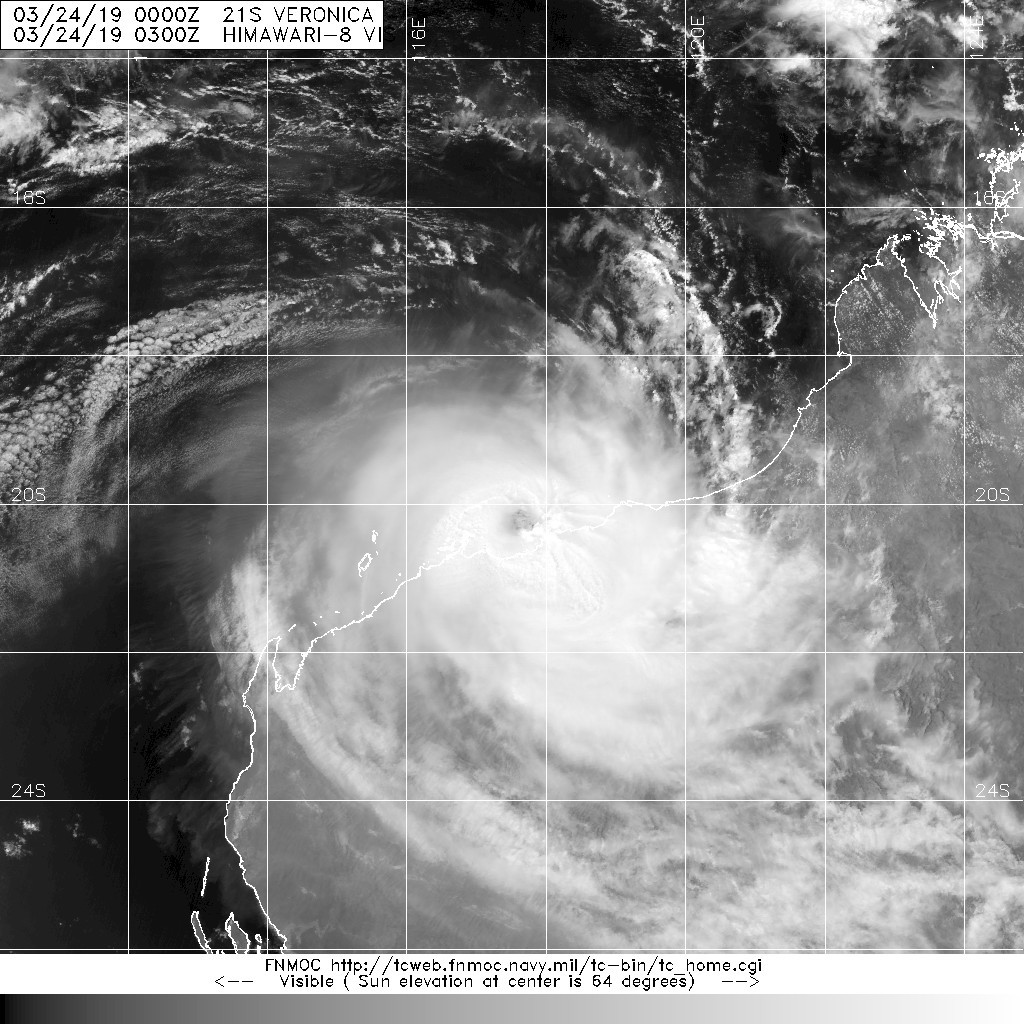
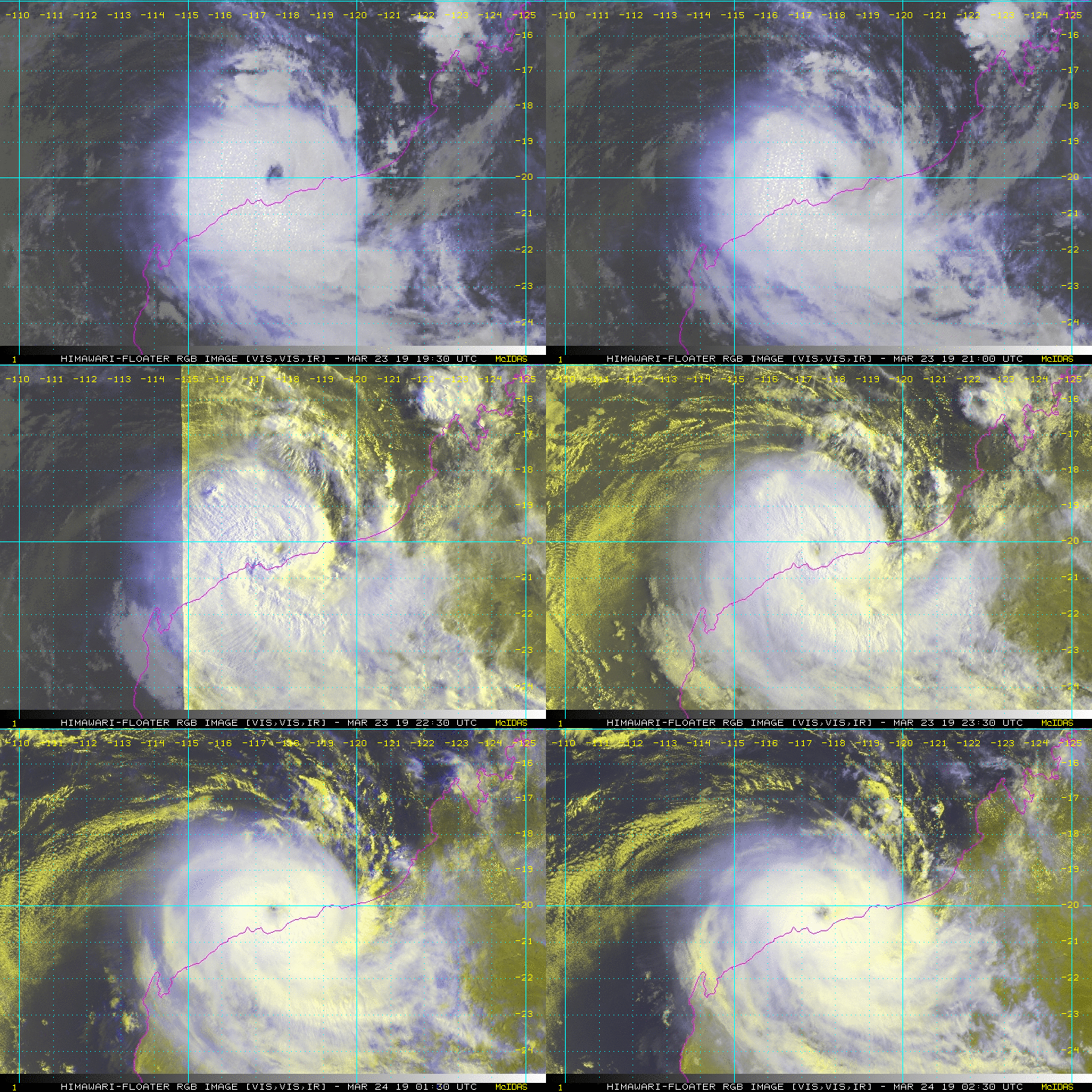
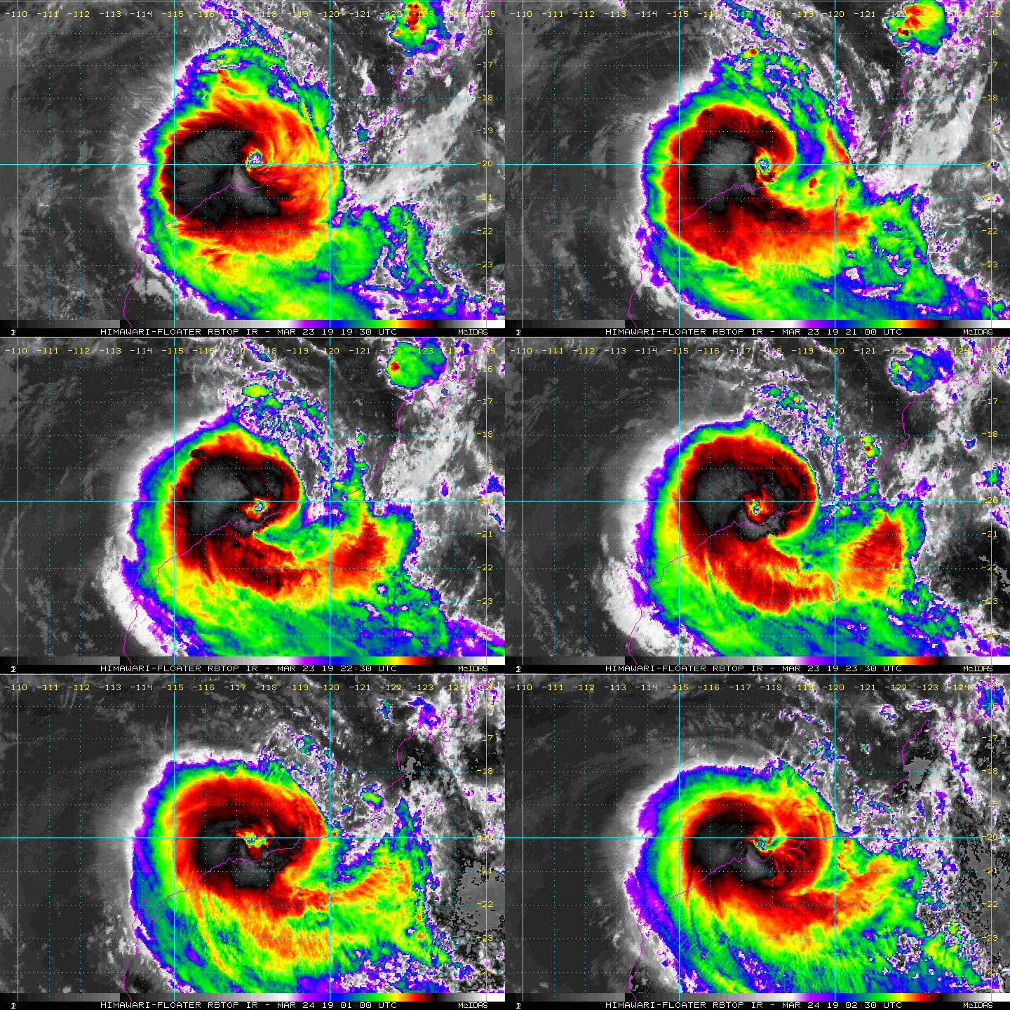
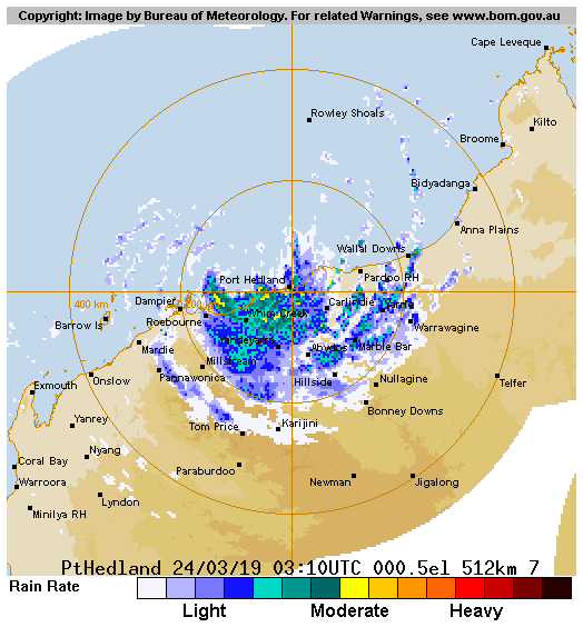
BoM 24/00Z、03Z定強為澳式C3上限,近中心最大風速為85kts(155km/h)。
依最新的雷達降水回波圖所示,風眼眼牆已抵達西澳西北部海岸,中心即將登陸。
IDW27600
TROPICAL CYCLONE TECHNICAL BULLETIN: AUSTRALIA - WESTERN REGION
Issued by PERTH TROPICAL CYCLONE WARNING CENTRE
at: 0054 UTC 24/03/2019
Name: Severe Tropical Cyclone Veronica
Identifier: 19U
Data At: 0000 UTC
Latitude: 20.3S
Longitude: 117.7E
Location Accuracy: within 15 nm [30 km]
Movement Towards: south southeast [160 deg]
Speed of Movement: 5 knots [10 km/h]
Maximum 10-Minute Wind: 85 knots [155 km/h]
Maximum 3-Second Wind Gust: 120 knots [220 km/h]
Central Pressure: 952 hPa
Radius of 34-knot winds NE quadrant: 110 nm [205 km]
Radius of 34-knot winds SE quadrant: 80 nm [150 km]
Radius of 34-knot winds SW quadrant: 90 nm [165 km]
Radius of 34-knot winds NW quadrant: 100 nm [185 km]
Radius of 48-knot winds NE quadrant: 65 nm [120 km]
Radius of 48-knot winds SE quadrant: 55 nm [100 km]
Radius of 48-knot winds SW quadrant: 65 nm [120 km]
Radius of 48-knot winds NW quadrant: 65 nm [120 km]
Radius of 64-knot winds: 35 nm
Radius of Maximum Winds: 25 nm [45 km]
Dvorak Intensity Code: T5.0/5.0/S0.0/24HRS STT:S0.0/06HRS
Pressure of outermost isobar: 1000 hPa
Radius of outermost closed isobar: 140 nm [260 km]
FORECAST DATA
Date/Time    : Location    : Loc. Accuracy: Max Wind   : Central Pressure
[UTC]        : degrees     :      nm  [km]: knots[km/h]: hPa
+06:  24/0600: 20.7S 117.8E:     025 [050]:  085  [155]:  950
+12:  24/1200: 20.9S 117.9E:     040 [070]:  075  [140]:  958
+18:  24/1800: 21.0S 117.8E:     050 [095]:  055  [100]:  970
+24:  25/0000: 21.0S 117.7E:     065 [120]:  050  [095]:  980
+36:  25/1200: 21.0S 117.2E:     085 [155]:  035  [065]:  992
+48:  26/0000: 21.2S 115.9E:     105 [190]:  030  [055]:  997
+60:  26/1200:             :              :            :     
+72:  27/0000:             :              :            :     
+96:  28/0000:             :              :            :     
+120: 29/0000:             :              :            :     
REMARKS:
Severe TC Veronica has maintained a high-end category 3 status over the past 6
to 8 hours. The strongest convection overnight was  persistently in the
southwest quadrant, though convection has increased in the southeast and
southern flanks of the system in the last 3 hours. Veronica continues to display
a large eye [40nm in diameter], which has generally been somewhat irregular
and/or ragged with smaller scale vortices embeded in the eyewall/eye interface.
This has recently led to the appearance of some irregular motion. The eye is
readily evident on satelltie and radar imagery, giving high confidence in the
location of the system centre.

Dvorak analysis has been between 4.5 and 5.0 in the last 6 hours based on an eye
pattern. Adjusted MET is 5.0. FT is 5.0 and CI is 5.0, with intensity set at 85
knots. CIMSS ADT CI is around 5.7, NESDIS ADT CI has risen to 6.2 with a return
to EYE pattern. SATCON at 2220UTC was 110 knots [1-minute winds].

Conditions remain somewhat conducive to develoment for the next 12 hours while
the system remains over water. Wind shear is presently northwesterly around 15
knots. Strong poleward outflow persists in the upper levels, with no equatorward
outflow visible. SSTs in the vicinity are over 30C. Dry air to the north is
slowly encroaching on the eastern flank of the system, but does not appear to be
infiltrating into the core region at present. Wind shear should increase over
the system as it tracks further south which should see the dry air further
ingested, contributing to a weakening trend.

The combination of a broad mid-latitude upper trough to the south and a
mid-level ridge to the east is expected to steer the system towards the south
southeast over the next 12 hours. Recent motion of the system has been somewhat
irregular as these steering features are currently very weak. Landfall is still
anticipated later today, but due to the slow moving nature of Veronica, the eye
and most significant impacts from the system may persist for 12 to 24 hours near
the coast. The movement over land later on Sunday and early next week varies
considerably in the guidance, but a westwards track close to the coast seems the
most likely as the system weakens due to a strengthening mid-level ridge over
Western Australia. It is unlikely to remain a tropical cyclone after Monday,
even if it moves back over water, as the environment becomes very unfavourable.

High tides will be close to the highest astronomical tide exacerbating the risk
of a significant storm tide impact, and Port Hedland has already recorded a
storm tide about 1m above HAT at midnight. The slow motion also means that
rainfall totals will be higher than for normal cyclone rainfall amounts and
cumulative totals in excess of 500mm are possible.

Copyright Commonwealth of Australia
==
The next bulletin for this system will be issued by: 24/0730 UTC by Perth TCWC.
IDW24100

Australian Government Bureau of Meteorology
Western Australia
Tropical Cyclone Warning Centre

Media: Transmitters serving the area between Pardoo and Dampier, including Port Hedland, are requested to USE the Standard Emergency Warning Signal before broadcasting the following warning.

TOP PRIORITY FOR IMMEDIATE BROADCAST
TROPICAL CYCLONE ADVICE NUMBER 46
Issued at 11:10 am WST on Sunday 24 March 2019

Headline:
Severe Tropical Cyclone Veronica is causing DESTRUCTIVE winds and heavy rainfall on the central Pilbara coast between Dampier and Port Hedland.

Areas Affected:
Warning Zone
Wallal to Mardie, including Port Hedland and Karratha, and adjacent inland areas, including Pannawonica

Watch Zone
None

Cancelled Zone
None.

Details of Severe Tropical Cyclone Veronica at 11:00 am AWST:
Intensity: Category 3, sustained winds near the centre of 155 kilometres per hour with wind gusts to 220 kilometres per hour.

Location: within 30 kilometres of 20.3 degrees South 117.7 degrees East, estimated to be 90 kilometres west of Port Hedland and 100 kilometres east northeast of Karratha.

Movement: south southeast at 6 kilometres per hour.

The cyclone's core has reached land and is over the coast just east of Roebourne and west of Port Hedland. The centre is forecast to remain near the coast today and tonight. Veronica is forecast weaken during Monday and start moving to the west.

Hazards:
VERY DESTRUCTIVE WINDS with gusts in excess of 165 kilometres per hour are expected near the cyclone centre today and tonight. This includes Roebourne, Wickham and Point Samson.

DESTRUCTIVE WINDS with gusts exceeding 125 kilometres per hour are occurring along the Pilbara coast between Dampier and Port Hedland and are forecast to extend to adjacent inland areas today.

GALES with gusts to 100 kilometres per hour are expected between remaining parts between Mardie and Pardoo, and may extend to adjacent inland areas including Pannawonica later today. They may also extend east of Wallal Downs tonight if the system moves further east.

The slow movement of the cyclone means that communities in the path of the cyclone should prepare to shelter from the destructive winds for an extended period today and into tomorrow.

Widespread very heavy rainfall conducive to MAJOR FLOODING is likely over the Pilbara coast and adjacent inland areas today and Monday. Heavy rainfall is expected to result in significant river rises, areas of flooding and hazardous road conditions. Some roads may become impassable and some communities may become isolated. Flood Warnings and Watches are current, please refer to http://www.bom.gov.au/wa/warnings/ for further details.

People along the Pilbara coast east of Wickham are warned of the potential for a VERY DANGEROUS STORM TIDE on the high tide today (high tide at 1pm at Port Hedland) and tonight (high tide at 1:30am Monday at Port Hedland). Tides are likely to rise significantly above the normal high tide mark with DAMAGING WAVES and VERY DANGEROUS COASTAL INUNDATION. Tides in remaining areas of the warning area are advised that tides will rise above the normal high tide with some flooding of low-lying coastal areas.

Recommended Action:
DFES advises of the following community alerts:

RED ALERT: People in or near communities between Pardoo and Mardie, including Port Hedland, South Hedland, Whim Creek, Point Samson, Wickham, Roebourne, Karratha, Dampier but excluding Marble Bar, need to go to shelter immediately.

YELLOW ALERT: People in or near remaining communities between Wallal and Pardoo and inland to Marble Bar need to take action and get ready to shelter from a cyclone.

BLUE ALERT: People in or near communities for parts of the inland Pilbara including Pannawonica need to prepare for cyclonic weather and organise an emergency kit including first aid kit, torch, portable radio, spare batteries, food and water.

ALL CLEAR: People in Nullagine are advised that there is no longer the risk of gales

Next Advice:
The next advice will be issued by 12:00 pm AWST Sunday 24 March.

Cyclone advices and DFES Alerts are available by dialling 13 DFES (13 3337)
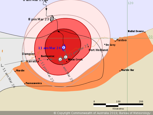
IDW60280.png IDR161.gif 20190324.0300.himawari-8.vis.21S.VERONICA.115kts.938mb.20.1S.117.5E.100pc.jpg rgb_lalo-animated (1).gif rbtop_lalo-animated (1).gif


回復

使用道具 舉報

簽到天數: 868 天

[LV.10]以壇為家III

jrchang5|2019-3-24 18:55 | 顯示全部樓層
BoM最新一報指出24/10Z中心仍在黑德蘭港以西近岸緩慢飄移,預測今晚至明日中心都在近岸附近緩慢移動,並有逐漸轉向偏西及減弱的趨勢。
IDW24100

Australian Government Bureau of Meteorology
Western Australia
Tropical Cyclone Warning Centre

Media: Transmitters serving the area between west of Port Hedland and Dampier, are requested to USE the Standard Emergency Warning Signal before broadcasting the following warning.

TOP PRIORITY FOR IMMEDIATE BROADCAST
TROPICAL CYCLONE ADVICE NUMBER 53
Issued at 5:55 pm WST on Sunday 24 March 2019

Headline:
Slow moving Severe Tropical Cyclone Veronica continues to produce DESTRUCTIVE winds and heavy rainfall on the central Pilbara coast between Dampier and Port Hedland.

Areas Affected:
Warning Zone
De Grey to Mardie, including Port Hedland and Karratha and Barrow Island, and adjacent inland areas, including Pannawonica

Watch Zone
None

Cancelled Zone
None.

Details of Severe Tropical Cyclone Veronica at 6:00 pm AWST:
Intensity: Category 3, sustained winds near the centre of 150 kilometres per hour with wind gusts to 205 kilometres per hour.

Location: within 35 kilometres of 20.5 degrees South 117.7 degrees East, estimated to be 95 kilometres east northeast of Karratha and 95 kilometres west southwest of Port Hedland.

Movement: slow moving.

The cyclone's core has reached land and is over the coast just east of Roebourne and west of Port Hedland. The centre is forecast to remain near the coast this evening and overnight. Veronica is forecast to weaken tonight and start to move to the west. Further weakening is expected during Monday.

Hazards:
VERY DESTRUCTIVE WINDS with gusts in excess of 165 kilometres per hour are expected near the cyclone centre Sunday evening and overnight. This includes Roebourne, Wickham and Point Samson.

DESTRUCTIVE WINDS with gusts exceeding 125 kilometres per hour are occurring along the Pilbara coast between Dampier and Port Hedland and are forecast to extend to adjacent inland areas this evening.

GALES with gusts to 100 kilometres per hour are expected in remaining parts between Pardoo and Mardie, and may extend to adjacent inland areas including Pannawonica this evening. Gales may extend to Barrow Island later Monday afternoon or evening.

The slow movement of the cyclone means that communities in the path of the cyclone should prepare to shelter from the destructive winds for an extended period tonight and Monday. Gales are likely to contract from the east including Port Hedland during Monday morning.

Widespread very heavy rainfall conducive to MAJOR FLOODING is likely over the Pilbara coast and adjacent inland areas today and Monday. Heavy rainfall is expected to result in significant river rises, areas of flooding and hazardous road conditions. Some roads may become impassable and some communities may become isolated. Flood Warnings and Watches are current, please refer to http://www.bom.gov.au/wa/warnings/ for further details.

People along the Pilbara coast east of Wickham are warned of the potential for a DANGEROUS STORM TIDE on the high tide overnight (high tide at 1:30am Monday at Port Hedland). Tides are likely to rise significantly above the normal high tide mark with DAMAGING WAVES and DANGEROUS COASTAL INUNDATION. Tides in remaining areas of the warning area are advised that tides will rise above the normal high tide with some flooding of low-lying coastal areas.

Recommended Action:
DFES advises of the following community alerts:

RED ALERT: People in or near communities between DeGrey and Mardie, including Port Hedland, South Hedland, Whim Creek, Point Samson, Wickham, Roebourne, Karratha, Dampier but excluding Marble Bar, need to go to shelter immediately.

BLUE ALERT: People in or near communities for parts of the inland Pilbara including Pannawonica. need to prepare for cyclonic weather and organise an emergency kit including first aid kit, torch, portable radio, spare batteries, food and water.

ALL CLEAR: People in or near Wallal to DeGrey and inland to Marble Bar, including Marble Bar, are advised that there is no longer the risk of gales.

Next Advice:
The next advice will be issued by 7:00 pm AWST Sunday 24 March.

Cyclone advices and DFES Alerts are available by dialling 13 DFES (13 3337)
IDW60280 (1).png IDR162.gif 20190324.0927.f18.91pct91h91v.21S.VERONICA.105kts.943mb.20.4S.117.7E.065pc.jpg rgb_lalo-animated (2).gif rbtop_lalo-animated (2).gif


回復

使用道具 舉報

簽到天數: 868 天

[LV.10]以壇為家III

jrchang5|2019-3-25 04:20 | 顯示全部樓層
由於垂直風切增強,高低層中心分離,高層已進入陸地,低層中心卻仍在黑德蘭港以西近岸滯留徘徊,BoM於24/18Z已降為澳式C2,JTWC亦降為熱帶風暴,預計其強度將持續減弱。

IDW27600
TROPICAL CYCLONE TECHNICAL BULLETIN: AUSTRALIA - WESTERN REGION
Issued by PERTH TROPICAL CYCLONE WARNING CENTRE
at: 1932 UTC 24/03/2019
Name: Tropical Cyclone Veronica
Identifier: 19U
Data At: 1800 UTC
Latitude: 20.3S
Longitude: 117.7E
Location Accuracy: within 20 nm [35 km]
Movement Towards: east [090 deg]
Speed of Movement: 0 knots [0 km/h]
Maximum 10-Minute Wind: 60 knots [110 km/h]
Maximum 3-Second Wind Gust: 85 knots [155 km/h]
Central Pressure: 972 hPa
Radius of 34-knot winds NE quadrant: 70 nm [130 km]
Radius of 34-knot winds SE quadrant: 60 nm [110 km]
Radius of 34-knot winds SW quadrant: 45 nm [85 km]
Radius of 34-knot winds NW quadrant: 45 nm [85 km]
Radius of 48-knot winds NE quadrant: 30 nm [55 km]
Radius of 48-knot winds SE quadrant: 35 nm [65 km]
Radius of 48-knot winds SW quadrant: 30 nm [55 km]
Radius of 48-knot winds NW quadrant: 30 nm [55 km]
Radius of 64-knot winds:
Radius of Maximum Winds: 20 nm [35 km]
Dvorak Intensity Code: T3.5/4.0/W1.5/24HRS STT:W1.0/06HRS
Pressure of outermost isobar: 1002 hPa
Radius of outermost closed isobar: 140 nm [260 km]
FORECAST DATA
Date/Time    : Location    : Loc. Accuracy: Max Wind   : Central Pressure
[UTC]        : degrees     :      nm  [km]: knots[km/h]: hPa
+06:  25/0000: 20.4S 117.3E:     030 [060]:  055  [100]:  978
+12:  25/0600: 20.5S 116.9E:     045 [080]:  040  [075]:  989
+18:  25/1200: 20.5S 116.5E:     055 [105]:  035  [065]:  993
+24:  25/1800: 20.6S 115.6E:     070 [130]:  035  [065]:  994
+36:  26/0600: 21.3S 114.0E:     090 [165]:  030  [055]:  997
+48:  26/1800: 21.8S 113.0E:     110 [200]:  025  [045]:  999
+60:  27/0600: 22.3S 111.8E:     130 [235]:  025  [045]:  999
+72:  27/1800: 22.3S 110.5E:     145 [270]:  025  [045]:  999
+96:  28/1800: 21.1S 107.5E:     190 [355]:  025  [045]: 1000
+120: 29/1800: 20.8S 104.0E:     280 [515]:  020  [035]: 1003
REMARKS:
TC Veronica is lingering near the Pilbara coast. The position is based primarily
on surface observations and RADAR.

The shear over the system has increased to around 15 knots, even though this is
not a high amount of shear the upper level core has sheared off [to the south
southeast] from the low level centre. The low level centre remains near coast
and convection may redevelop near the centre during the morning.

Dvorak analysis has been ambiguous with DT around 4 based on embedded centre
pattern, which is becoming less relevant. FT is based on the MET/PAT which is
3.5. CI is reduced to 4.0, with intensity set at 60 knots. No ADT. SATCON at
1711UTC was 74 knots [adjusted to 10-minute winds].

The system will continue to weaken during Monday with steadily increasing
northwesterly  wind shear. The environment is unfavourable with dry air around
the system and the possibility of some land interaction.

The broad mid-latitude upper trough to the south of the system is now waning in
influence as it moves east. As the system weakens it will be steered by a
strengthening low to mid-level ridge over central Western Australia. The latest
model guidance continues to move the system westwards along the Pilbara coast
during Monday.  It is likely to weaken below cyclone intensity by Monday night,
even if it moves back over water, as the environment becomes very unfavourable.

High tides will be close to the highest astronomical tide exacerbating the risk
of a significant storm tide impact. The slow motion also means that rainfall
totals will be higher than for normal cyclone rainfall amounts and cumulative
totals in excess of 300mm are possible over the next 24 hours.

Copyright Commonwealth of Australia
==
The next bulletin for this system will be issued by: 25/0130 UTC by Perth TCWC.

IDW60280 (2).png IDR162 (1).gif sh212019.20190324200017.gif 20190324.1920.himawari-8.ir.21S.VERONICA.60kts.978mb.20.4S.117.7E.100pc.jpg rgb_lalo-animated (3).gif rbtop_lalo-animated (3).gif

回復

使用道具 舉報

快速回覆
您需要登錄後才可以回帖 登錄 | 立即加入

本版積分規則

本平台僅供學術討論之用,預報應以氣象局為準

威普網站虛擬主機贊助公司

臺灣第一個天氣類型社群平台 即時天氣資訊、精準颱風動態

線上客服
FB傳送訊息
廣告行銷
精準行銷 物超所值
官方粉專
發佈 快速回復 返回頂部 返回列表