開啟輔助訪問
 找回密碼
 立即加入

27S.Odette 遭26S併吞

簽到天數: 483 天

[LV.9]以壇為家II

dom|2021-4-6 10:09 | 顯示全部樓層
BoM開始發報,首報不看好命名
IDW27700
TROPICAL CYCLONE TECHNICAL BULLETIN: AUSTRALIA - WESTERN REGION
Issued by AUSTRALIAN BUREAU OF METEOROLOGY TROPICAL CYCLONE WARNING CENTRE
at: 0133 UTC 06/04/2021
Name: Tropical Low  
Identifier: 23U
Data At: 0000 UTC
Latitude: 16.5S
Longitude: 105.3E
Location Accuracy: within 30 nm [55 km]
Movement Towards: southwest [224 deg]
Speed of Movement: 3 knots [5 km/h]
Maximum 10-Minute Wind: 35 knots [65 km/h]
Maximum 3-Second Wind Gust: 50 knots [95 km/h]
Central Pressure: 995 hPa
Radius of 34-knot winds NE quadrant:   
Radius of 34-knot winds SE quadrant:   
Radius of 34-knot winds SW quadrant: 90 nm [165 km]
Radius of 34-knot winds NW quadrant:   
Radius of 48-knot winds NE quadrant:   
Radius of 48-knot winds SE quadrant:   
Radius of 48-knot winds SW quadrant:   
Radius of 48-knot winds NW quadrant:   
Radius of 64-knot winds:
Radius of Maximum Winds:   
Dvorak Intensity Code: T2.5/2.5/S0.0/24HRS STT:S0.0/06HRS
Pressure of outermost isobar: 1006 hPa
Radius of outermost closed isobar: 150 nm [280 km]
FORECAST DATA
Date/Time    : Location    : Loc. Accuracy: Max Wind   : Central Pressure
[UTC]        : degrees     :      nm  [km]: knots[km/h]: hPa
+06:  06/0600: 16.6S 105.6E:     050 [095]:  030  [055]:  996
+12:  06/1200: 16.7S 106.0E:     070 [130]:  030  [055]:  996
+18:  06/1800: 16.5S 106.1E:     080 [145]:  030  [055]:  996
+24:  07/0000: 16.4S 105.9E:     085 [155]:  030  [055]:  996
+36:  07/1200: 16.2S 105.6E:     085 [160]:  035  [065]:  993
+48:  08/0000: 15.9S 105.4E:     105 [195]:  035  [065]:  993
+60:  08/1200: 15.8S 105.9E:     115 [215]:  040  [075]:  993
+72:  09/0000: 16.1S 106.6E:     145 [265]:  040  [075]:  991
+96:  10/0000: 18.2S 107.9E:     280 [515]:  035  [065]:  995
+120: 11/0000: 22.1S 108.2E:     400 [750]:  035  [065]:  994
REMARKS:
Tropical Low 23U was located overnight using microwave imagery and this
morning's visible satellite imagery has shown an exposed low level centre. This
leads to good confidence in the analysis location.

Over the past 3 hours average Dvorak values of T2.5 have been assessed using a
shear pattern, though in the past hour this has been approaching a T2.0 as the
low level centre has moved more than 3/4 of a degree from the edge of the deep
convection. ADT values have also been gradually decreasing over the past several
hours, with CIMSS ADT CI of 2.5 and NESDIS ADT CI of 2.4 at time of analysis.

ASCAT analysis this morning showed an area of gale force winds to the south of
the system with marginal storm force winds in the southwest quadrant. Consistent
with moderate to high northeasterly shear, there was no evidence of these
stronger winds wrapping around the northern side of the system. At the time of
that analysis, the low level circulation was embedded within the deep
convection, and has since removed, which is consistent with weakening of the
system. As such maximum winds assigned to the system are 35 knots [10-min mean]
though only expected in the southwest quadrant within the deep convection.

In the short term shear and dry air are forecast to affect the system weakening
it in the next 24 to 36 hours. From Thursday there is as significant decrease in
confidence due to potential interaction with Tropical Cyclone Seroja. There is
the potential for 23U to move north into a more favourable environment, and as a
result intensification could occur with gales initially developing about western
quadrants, though wrapping into the northern flank as 23U tracks to the north
and east as Seroja tracks to the southwest. Model guidance varies significantly
with this interaction and there is the potential for 23U to either weaken and
dissipate or to gradually become the more dominant system and develop further.
In the scenario where 23U develops, it is likely to remain well to the northwest
of Western Australia and could reach category 2 intensity.

In the longer term, the environment to the the northwest coast of Western
Australia is unfavourable for tropical system development, with a mixture of
high vertical wind shear and dry air. This means that in the event that 23U
takes a track that approaches the west Pilbara coast there is a very low risk of
any significant impact communities in that area.

Copyright Commonwealth of Australia
==
The next bulletin for this system will be issued by: 06/0730 UTC.
5D01F907-F699-408D-8AED-F3A825FA23B0.png
回復

使用道具 舉報

簽到天數: 483 天

[LV.9]以壇為家II

dom|2021-4-6 15:06 | 顯示全部樓層
BoM新報看好命名, 上望45節
IDW27700
TROPICAL CYCLONE TECHNICAL BULLETIN: AUSTRALIA - WESTERN REGION
Issued by AUSTRALIAN BUREAU OF METEOROLOGY TROPICAL CYCLONE WARNING CENTRE
at: 0656 UTC 06/04/2021
Name: Tropical Low  
Identifier: 23U
Data At: 0600 UTC
Latitude: 16.2S
Longitude: 105.3E
Location Accuracy: within 20 nm [35 km]
Movement Towards: north [000 deg]
Speed of Movement: 2 knots [4 km/h]
Maximum 10-Minute Wind: 35 knots [65 km/h]
Maximum 3-Second Wind Gust: 50 knots [95 km/h]
Central Pressure: 995 hPa
Radius of 34-knot winds NE quadrant:   
Radius of 34-knot winds SE quadrant:   
Radius of 34-knot winds SW quadrant: 80 nm [150 km]
Radius of 34-knot winds NW quadrant:   
Radius of 48-knot winds NE quadrant:   
Radius of 48-knot winds SE quadrant:   
Radius of 48-knot winds SW quadrant:   
Radius of 48-knot winds NW quadrant:   
Radius of 64-knot winds:
Radius of Maximum Winds:   
Dvorak Intensity Code: T2.5/2.5/D0.5/24HRS STT:S0.0/06HRS
Pressure of outermost isobar: 1004 hPa
Radius of outermost closed isobar: 130 nm [240 km]
FORECAST DATA
Date/Time    : Location    : Loc. Accuracy: Max Wind   : Central Pressure
[UTC]        : degrees     :      nm  [km]: knots[km/h]: hPa
+06:  06/1200: 16.1S 105.4E:     035 [065]:  035  [065]:  996
+12:  06/1800: 16.1S 105.5E:     055 [100]:  035  [065]:  997
+18:  07/0000: 16.0S 105.6E:     070 [130]:  035  [065]:  996
+24:  07/0600: 15.9S 105.7E:     090 [170]:  035  [065]:  996
+36:  07/1800: 15.6S 105.6E:     125 [230]:  035  [065]:  993
+48:  08/0600: 15.0S 105.5E:     150 [275]:  035  [065]:  990
+60:  08/1800: 14.5S 106.5E:     175 [325]:  040  [075]:  990
+72:  09/0600: 14.4S 108.2E:     155 [285]:  045  [085]:  988
+96:  10/0600: 16.4S 110.6E:     330 [620]:  035  [065]:  991
+120: 11/0600: 20.5S 111.4E:     390 [720]:  035  [065]:  997
REMARKS:
Tropical Low 23U has been located using visible satellite imagery today with an
exposed low level centre earlier in the day providing good confidence in the
analysis location.

Deep convection has redeveloped southwest of the centre over the past 3 hours.
Data T values of 2.5 to 3 from a shear pattern over the past 3 hours, biasing
towards 2.5 due to satellite observations analysing 35 knots only in the
convection to the southwest and not wrapping around the system. ADT values have
been significantly lower, between 2.0 and 2.5 as this is being analysed with a
curved band pattern.

ASCAT analysis at 0250Z presented an area of gale force winds extending
approximately 80nm in the southwest quadrant. Consistent with moderate to high
northeasterly shear, there was no evidence of these stronger winds wrapping
around the northern side of the system.

In the short term shear and dry air are forecast to constrain development of
23U, though gale force winds are forecast to persist in the southwest quadrant.
From Thursday there is a significant decrease in confidence due to potential
interaction with Tropical Cyclone Seroja. There is the potential for 23U to move
north into a more favourable environment, and as a result intensification could
occur with gales initially developing about western quadrants, though wrapping
into the northern flank as 23U tracks to the northeast as Seroja tracks to the
southwest. Model guidance varies significantly with this interaction and there
is the potential for 23U to either weaken and dissipate or to gradually become
the more dominant system and develop further. In the scenario where 23U
develops, it is likely to remain well to the northwest of Western Australia and
could reach category 3 intensity.

In the longer term, the environment north of the northwest coast of Western
Australia is unfavourable for tropical system development, with a mixture of
high vertical wind shear and dry air. This means that in the event that 23U
takes a track that approaches the west Pilbara coast there is only a low risk of
any significant impacts occurring to communities in that area.

Copyright Commonwealth of Australia
==
The next bulletin for this system will be issued by: 06/1330 UTC.
IDW60284.png
回復

使用道具 舉報

簽到天數: 1650 天

[LV.Master]伴壇終老

老農民版夜神月|2021-4-6 15:10 | 顯示全部樓層
本帖最後由 老農民版夜神月 於 2021-4-6 15:26 編輯

BoM新報改為預測將於+48H命名
Details:

Time (AWST)Intensity CategoryLatitude
(decimal deg.)
Longitude
(decimal deg.)
Estimated Position
Accuracy (km)
0hr2 pm April 6tropical low16.2S105.3E35
+6hr8 pm April 6tropical low16.1S105.4E65
+12hr2 am April 7tropical low16.1S105.5E100
+18hr8 am April 7tropical low16.0S105.6E130
+24hr2 pm April 7tropical low15.9S105.7E170
+36hr2 am April 8tropical low15.6S105.6E230
+48hr2 pm April 8115.0S105.5E275
+60hr2 am April 9114.5S106.5E325
+72hr2 pm April 9114.4S108.2E285

IDW60284 (1).png


20210406.0630.himawari-8.vis.27S.TWENTYSEVE.45kts.998mb.15.8S.105.2E.100pc.jpg LATEST - 2021-04-06T150725.481.jpg
回復

使用道具 舉報

簽到天數: 483 天

[LV.9]以壇為家II

dom|2021-4-7 14:12 | 顯示全部樓層
BoM評級提升至High
A tropical low (23U) lies well to the south of Christmas Island and will be slow moving today. From late Thursday it is possible for the low to strengthen to tropical cyclone intensity and start moving towards the east.
There remains some uncertainty in the track and intensity on Friday and Saturday. With Tropical Cyclone Seroja approaching from the northeast, the interaction between these two systems is likely to limit development of the tropical low. There is the risk of a period of strong winds and rain associated with this system across the northwest corner of the State over the weekend.

Likelihood of this system being a tropical cyclone in the Western Region on:
Thursday:Moderate
Friday:High
Saturday:Moderate
E17F0924-7455-458A-A748-4DACEE97A9F2.jpeg
回復

使用道具 舉報

簽到天數: 1650 天

[LV.Master]伴壇終老

老農民版夜神月|2021-4-8 00:46 | 顯示全部樓層
風場持續掃出TS風力,若不是BoM命名標準實在太過嚴苛

在其他任何一個洋面甚至是任何一個其他機構轄區,27S應該都是早該獲名的

LATEST - 2021-04-07T235430.082.jpg LATEST - 2021-04-07T235419.427.jpg
IDW60284 (3).png 20210407.1620.himawari-8.ir.27S.TWENTYSEVE.40kts.996mb.16.2S.106.2E.100pc.jpg
回復

使用道具 舉報

簽到天數: 483 天

[LV.9]以壇為家II

dom|2021-4-8 14:22 | 顯示全部樓層
本帖最後由 dom 於 2021-4-8 21:02 編輯

螢幕快照 2021-04-08 下午2.13.29.png
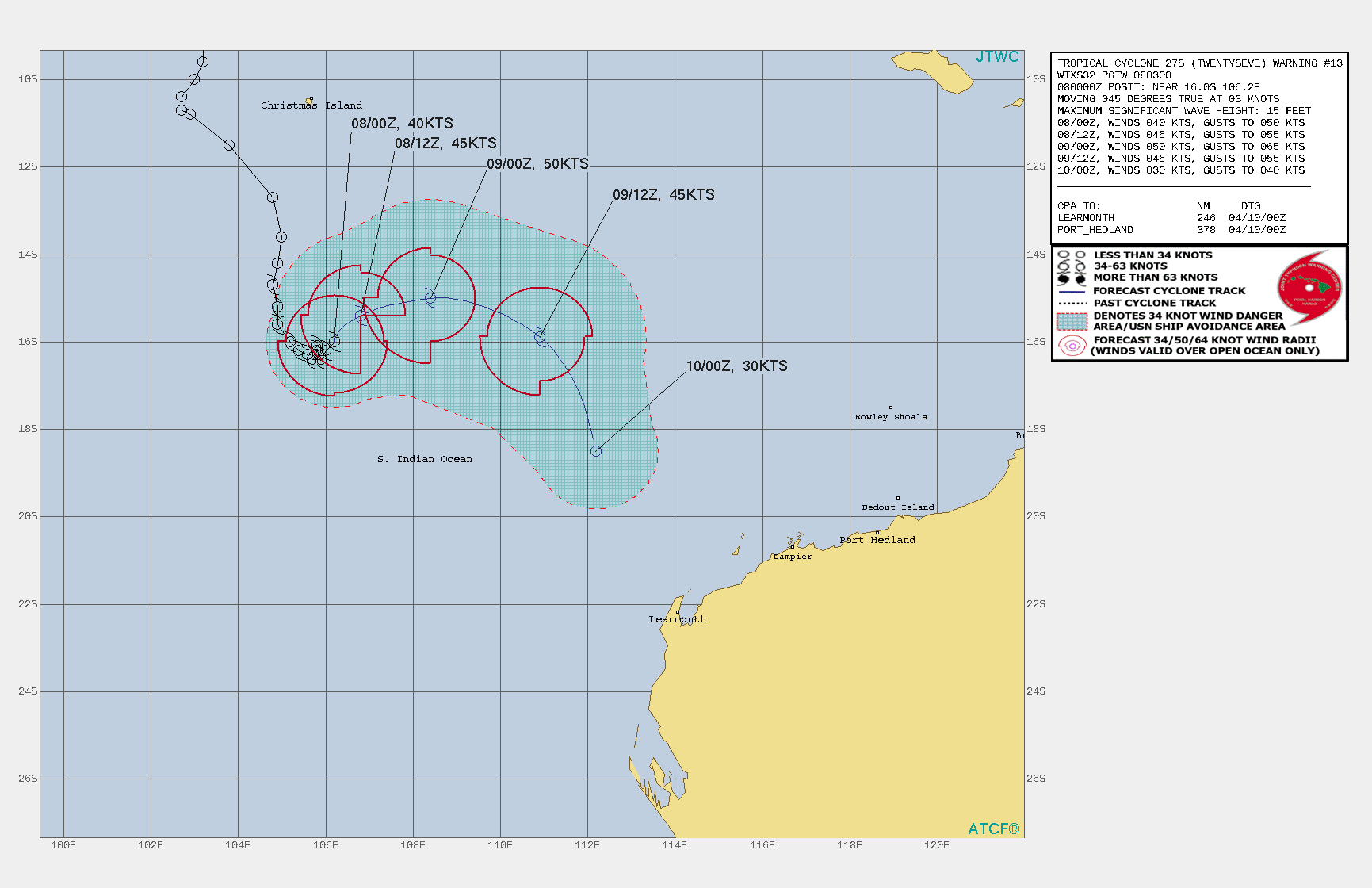
已經是逐漸被吞併的節奏
JTWC預測短時間內還有些微增強的空間, 並於48小時內完全被26S吞噬
WTXS32 PGTW 080300
MSGID/GENADMIN/JOINT TYPHOON WRNCEN PEARL HARBOR HI//
SUBJ/TROPICAL CYCLONE 27S (TWENTYSEVEN) WARNING NR 013//
RMKS/
1. TROPICAL CYCLONE 27S (TWENTYSEVEN) WARNING NR 013   
   02 ACTIVE TROPICAL CYCLONES IN SOUTHIO
   MAX SUSTAINED WINDS BASED ON ONE-MINUTE AVERAGE
   WIND RADII VALID OVER OPEN WATER ONLY
    ---
   WARNING POSITION:
   080000Z --- NEAR 16.0S 106.2E
     MOVEMENT PAST SIX HOURS - 045 DEGREES AT 03 KTS
     POSITION ACCURATE TO WITHIN 025 NM
     POSITION BASED ON CENTER LOCATED BY SATELLITE
   PRESENT WIND DISTRIBUTION:
   MAX SUSTAINED WINDS - 040 KT, GUSTS 050 KT
   WIND RADII VALID OVER OPEN WATER ONLY
   RADIUS OF 034 KT WINDS - 065 NM NORTHEAST QUADRANT
                            070 NM SOUTHEAST QUADRANT
                            075 NM SOUTHWEST QUADRANT
                            065 NM NORTHWEST QUADRANT
   REPEAT POSIT: 16.0S 106.2E
    ---
   FORECASTS:
   12 HRS, VALID AT:
   081200Z --- 15.4S 106.8E
   MAX SUSTAINED WINDS - 045 KT, GUSTS 055 KT
   WIND RADII VALID OVER OPEN WATER ONLY
   RADIUS OF 034 KT WINDS - 060 NM NORTHEAST QUADRANT
                            000 NM SOUTHEAST QUADRANT
                            080 NM SOUTHWEST QUADRANT
                            070 NM NORTHWEST QUADRANT
   VECTOR TO 24 HR POSIT: 075 DEG/ 08 KTS
    ---
   24 HRS, VALID AT:
   090000Z --- 15.0S 108.4E
   MAX SUSTAINED WINDS - 050 KT, GUSTS 065 KT
   WIND RADII VALID OVER OPEN WATER ONLY
   RADIUS OF 034 KT WINDS - 060 NM NORTHEAST QUADRANT
                            060 NM SOUTHEAST QUADRANT
                            090 NM SOUTHWEST QUADRANT
                            070 NM NORTHWEST QUADRANT
   VECTOR TO 36 HR POSIT: 110 DEG/ 13 KTS
    ---
   36 HRS, VALID AT:
   091200Z --- 15.9S 110.9E
   MAX SUSTAINED WINDS - 045 KT, GUSTS 055 KT
   WIND RADII VALID OVER OPEN WATER ONLY
   DISSIPATING AS A SIGNIFICANT TROPICAL CYCLONE OVER WATER
   RADIUS OF 034 KT WINDS - 070 NM NORTHEAST QUADRANT
                            060 NM SOUTHEAST QUADRANT
                            080 NM SOUTHWEST QUADRANT
                            070 NM NORTHWEST QUADRANT
   VECTOR TO 48 HR POSIT: 155 DEG/ 14 KTS
    ---
   EXTENDED OUTLOOK:
   48 HRS, VALID AT:
   100000Z --- 18.5S 112.2E
   MAX SUSTAINED WINDS - 030 KT, GUSTS 040 KT
   WIND RADII VALID OVER OPEN WATER ONLY
   DISSIPATED AS A SIGNIFICANT TROPICAL CYCLONE OVER WATER
    ---
REMARKS:
080300Z POSITION NEAR 15.8S 106.4E.
08APR21. TROPICAL CYCLONE (TC) 27S (TWENTYSEVEN), LOCATED
APPROXIMATELY 586 NM NORTHWEST OF LEARMONTH, AUSTRALIA, HAS TRACKED
NORTHEASTWARD AT 03 KNOTS OVER THE PAST SIX HOURS. ANIMATED 6-HR
MULTISPECTRAL SATELLITE IMAGERY SHOWS THE SYSTEM HAS MOSTLY
MAINTAINED CONVECTIVE SIGNATURE AS IT STAYED QUASI-STATIONARY (QS)IN
A WEAK STEERING ENVIRONMENT EVEN AS THE MAIN CONVECTION REMAINS
SHEARED WESTWARD OF A PARTLY-EXPOSED LOW LEVEL CIRCULATION. THE
INITIAL POSITION IS PLACED WITH FAIR CONFIDENCE BASED ON A NOTCH
FEATURE IN THE 072253Z SSMIS 37GHZ MICROWAVE IMAGE. THE INITIAL
INTENSITY OF 40KTS IS BASED ON THE ADT ESTIMATE OF T2.7/39KTS AND
HEDGED HIGHER THAN THE DVORAK ESTIMATES OF T2.5/35KTS FROM PGTW AND
KNES TO REFLECT THE SUSTAINED CONVECTIVE SIGNATURE. ANALYSIS
INDICATES THE CYCLONE IS IN A MARGINAL ENVIRONMENT WITH STRONG
SUBSIDENCE ALOFT ALONG THE EASTERN HALF DUE TO THE OUTFLOW FROM TC
26S AND MODERATE TO STRONG (20-25KT) EASTERLY VERTICAL WIND SHEAR
THAT ARE PARTLY OFFSET BY WARM (29C) SEA SURFACE TEMPERATURE. THE
SYSTEM IS IN A NEUTRAL AREA BETWEEN A LOW REFLECTION OF THE
SUBTROPICAL RIDGE TO THE SOUTHWEST, WEAK NEAR EQUATORIAL RIDGING TO
THE NORTHWEST, AND OUTFLOW PRESSURE FROM AN APPROACHING TC 26S,
CURRENTLY 420NM TO THE EAST. AS TC 26S GETS CLOSER, A BINARY
INTERACTION WILL COMMENCE DUE TO FUJIWARA EFFECT RESULTING IN TC 26S
TRACKING CYCLONICALLY INTO AN ARC NORTHEASTWARD. THE WARM WATER AND
INCREASED OUTFLOW WILL MARGINALLY OFFSET THE VWS AND PROMOTE A MODEST
INTENSIFICATION TO A PEAK OF 50KTS AS IT CRESTS THE ARC. AFTERWARD,
IT WILL RAPIDLY DECAY AS IT GETS RAPIDLY ABSORBED INTO THE LARGER AND
MUCH MORE DOMINANT TC 26S LEADING TO DISSIPATION BY TAU 48, POSSIBLY
SOONER. THE NUMERICAL MODELS ARE IN FAIRLY GOOD AGREEMENT WITH
GRADUAL SPREADING; HOWEVER, GIVEN THE UNCERTAINTIES IN THE INITIAL
STORM MOTION AND THE COMPLEX DYNAMICS OF THE BINARY INTERACTION,
THERE IS LOW CONFIDENCE IN THE JTWC TRACK FORECAST. MAXIMUM
SIGNIFICANT WAVE HEIGHT AT 080000Z IS 15 FEET. NEXT WARNINGS AT
080900Z, 081500Z, 082100Z AND 090300Z. REFER TO TROPICAL CYCLONE 26S
(SEROJA) WARNINGS (WTXS31 PGTW) FOR SIX-HOURLY UPDATES.//
NNNN
123920xcf9yookafq8oc2x.gif
回復

使用道具 舉報

簽到天數: 1650 天

[LV.Master]伴壇終老

老農民版夜神月|2021-4-9 04:20 | 顯示全部樓層
BoM新報仍然支持+6H後升格澳式C1,今天一整天可能是27S獲銘的最後機會了
IDW60284.png
Time (AWST)Intensity CategoryLatitude
(decimal deg.)
Longitude
(decimal deg.)
Estimated Position
Accuracy (km)
0hr2 am April 9tropical low14.5S106.3E35
+6hr8 am April 9114.3S107.3E70
+12hr2 pm April 9114.6S108.6E90
+18hr8 pm April 9115.2S110.2E105
+24hr2 am April 10116.3S111.5E120
+36hr2 pm April 10tropical low19.8S112.3E195
+48hr2 am April 11tropical low24.2S110.7E270
+60hr2 pm April 11tropical lowXXXXXXXXX
+72hr2 am April 12tropical lowXXXXXXXXX

20210408.1950.himawari-8.ir.27S.TWENTYSEVE.40kts.997mb.14.3S.106.3E.100pc.jpg
20210408.1838.gw1.89pct89h89v.27S.TWENTYSEVE.40kts.997mb.14.3S.106.3E.67pc.jpg 20210408.1838.gw1.89hbt.27S.TWENTYSEVE.40kts.997mb.14.3S.106.3E.67pc.jpg
回復

使用道具 舉報

簽到天數: 483 天

[LV.9]以壇為家II

dom|2021-4-9 09:13 | 顯示全部樓層
BoM01Z升格澳式C1, 命名Odette
Details of Tropical Cyclone Odette at 8:00 am AWST:
Intensity: Category 1, sustained winds near the centre of 85 kilometres per hour with wind gusts to 120 kilometres per hour.

Location: within 35 kilometres of 14.2 degrees South 107.7 degrees East, estimated to be 1100 kilometres northwest of Exmouth and 470 kilometres south southeast of Christmas Island.

Movement: east northeast at 20 kilometres per hour.

Tropical Cyclone Odette is located well to the northwest of the WA mainland. It is currently moving to the east-northeast as it interacts with Tropical Cyclone Seroja which is located to the southeast. Odette is forecast to move east to southeast for the remainder of Friday before rapidly tracking to the south-southwest during Saturday, passing to the west of the Pilbara.

Tropical Cyclone Odette is only expected to be a short-lived system as it is likely to weaken during its interaction with Tropical Cyclone Seroja over the weekend. By Sunday the system is likely to have weakened over waters west of the Gascoyne coast.

Although Tropical Cyclone Odette is likely to weaken below tropical cyclone intensity before approaching the northwest of WA, there is the risk of a period of damaging winds and rain developing between Exmouth and Coral Bay during Saturday. A Severe Weather Warning is in place for the west Pilbara and northwest Gascoyne, refer to http:/www.bom.gov.au/wa/warnings/ for latest details.
IDW60284.png
回復

使用道具 舉報

快速回覆
您需要登錄後才可以回帖 登錄 | 立即加入

本版積分規則

本平台僅供學術討論之用,預報應以氣象局為準

威普網站虛擬主機贊助公司

臺灣第一個天氣類型社群平台 即時天氣資訊、精準颱風動態

線上客服
FB傳送訊息
廣告行銷
精準行銷 物超所值
官方粉專
發佈 快速回復 返回頂部 返回列表