開啟輔助訪問
 找回密碼
 立即加入

09E.Jimena 整合數日終命名 進入中太

簽到天數: 1650 天

[LV.Master]伴壇終老

老農民版夜神月|2021-8-6 04:52 | 顯示全部樓層
即將進入中太
000
WTPZ44 KNHC 052032
TCDEP4

Tropical Storm Jimena Discussion Number  12
NWS National Hurricane Center Miami FL       EP092021
1100 AM HST Thu Aug 05 2021

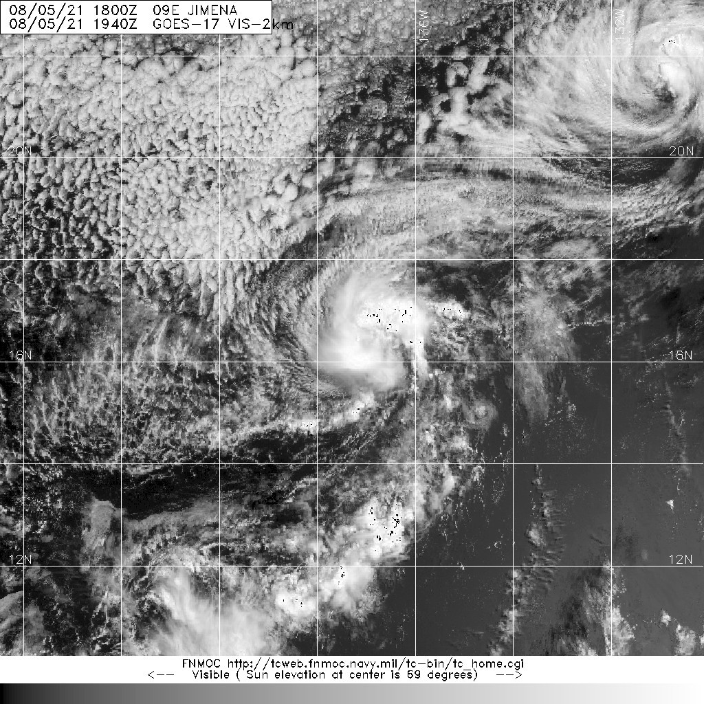
Jimena's cloud pattern, which has changed little since earlier this
morning, consists of a fragmented curved band in the northwestern
semicircle and a patch of deep convection just to the southeast of
the surface center.  The subjective Dvorak satellite intensity
estimates from TAFB and SAB remain unchanged (T2.5) and the initial
intensity is held at 35 kt.

Jimena has about another 12 hours or so before it traverses
decreasing (sub-25C) sea-surface temperatures, and the surrounding
environment becomes less favorable due to an intruding dry and
stable air mass.  Increasing west-northwesterly shear is also
expected to negatively affect the cyclone beyond the 36 hour period.
The official intensity forecast, which is similar to the IVCN
intensity consensus model, indicates Jimena becoming a depression
in about 24 hours and further weakening to a remnant low on
Saturday, and opening up into a trough of low pressure on Sunday.

The initial motions is estimated to be northwest, or 310/7 kt.  A
mid-tropospheric ridge situated to the northeast of the cyclone
should keep Jimena moving toward the northwest through the 48
period.  Afterward, a turn toward the west-northwest is forecast as
the vertically shallow system is steered by the low-level
environmental flow.  The NHC track forecast, once again, follows
the TVCN consensus aid closely, and is similar to the previous
advisory.


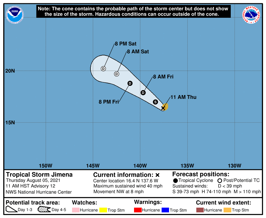
FORECAST POSITIONS AND MAX WINDS

INIT  05/2100Z 16.4N 137.6W   35 KT  40 MPH
12H  06/0600Z 17.0N 138.4W   35 KT  40 MPH
24H  06/1800Z 17.9N 139.7W   30 KT  35 MPH
36H  07/0600Z 18.8N 141.1W   30 KT  35 MPH
48H  07/1800Z 19.7N 142.5W   25 KT  30 MPH...POST-TROP/REMNT LOW
60H  08/0600Z 20.2N 143.9W   25 KT  30 MPH...POST-TROP/REMNT LOW
72H  08/1800Z...DISSIPATED

$$
Forecaster Roberts
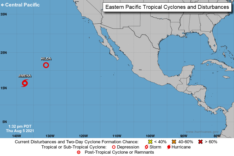
two_pac_0d0.png 203447_5day_cone_no_line_and_wind.png
20210805.1940.goes-17.vis.2km.09E.JIMENA.35kts.1005mb.16.2N.137.3W.pc.jpg
回復

使用道具 舉報

簽到天數: 1650 天

[LV.Master]伴壇終老

老農民版夜神月|2021-8-7 04:57 | 顯示全部樓層
進入中太,將交由CPHC發報,不過照預報來看大概會跟06E.Felicia一樣一兩報就會停編 203254_5day_cone_no_line_and_wind.png
000
WTPZ44 KNHC 062032
TCDEP4

Tropical Depression Jimena Discussion Number  16
NWS National Hurricane Center Miami FL       EP092021
1100 AM HST Fri Aug 06 2021

During the last 6 hours, deep convection associated with Jimena has
waned.  A recently arriving 1756 UTC ASCAT pass revealed peak
believable winds of around 30 kt.  The latest Dvorak T- and
CI-numbers from TAFB and SAB have also decreased, and these
data support lowering the initial intensity to 30 kt.  Jimena is
currently moving over SSTs near 24C and into a more stable air mass.
In addition, westerly shear will increase along the cyclone's path
during the next 12 hours.  These factors should cause continued
weakening, and Jimena is expected to degenerate into a remnant low
by late tonight or early Saturday.

The initial motion estimate is 295/7 kt.  The west-northwestward
motion is forecast to continue for another day or so, followed by a
gradual bend to the west as Jimena weakens and is steered by the
low-level trade wind flow.  The new track forecast is slightly to
the south of the previous NHC advisory, and is in best agreement
with the HCCA and TVCN consensus models.

Jimena is crossing into the central Pacific basin, and this will be
the final NHC advisory on this system. Future information on Jimena
can be found in Forecast/Advisories issued by the Central Pacific
Hurricane Center beginning at 0300 UTC under AWIPS header HFOTCMCP2
and WMO header WTPA22 PHFO.


FORECAST POSITIONS AND MAX WINDS

INIT  06/2100Z 17.6N 140.0W   30 KT  35 MPH
12H  07/0600Z 18.2N 141.2W   25 KT  30 MPH...POST-TROP/REMNT LOW
24H  07/1800Z 18.8N 142.5W   25 KT  30 MPH...POST-TROP/REMNT LOW
36H  08/0600Z 19.1N 143.9W   20 KT  25 MPH...POST-TROP/REMNT LOW
48H  08/1800Z 19.2N 145.5W   20 KT  25 MPH...POST-TROP/REMNT LOW
60H  09/0600Z...DISSIPATED

$$
Forecaster Hagen/Brown
20210806.2000.goes-17.vis.2km.09E.JIMENA.30kts.1008mb.17.5N.139.7W.pc.jpg 20210806.1552.f17.91pct91h91v.09E.JIMENA.35kts.1006mb.17.3N.139W.090pc.jpg
回復

使用道具 舉報

簽到天數: 1650 天

[LV.Master]伴壇終老

老農民版夜神月|2021-8-7 09:13 | 顯示全部樓層
結果果真又是一進轄區馬上判定為LO

CPHC這也是沒準了,真夠懶的
EP, 09, 2021080700, , BEST, 0, 178N, 1405W, 30, 1009, LO,

20210806.1740.goes-17.vis.2km.09E.JIMENA.35kts.1006mb.17.3N.139W.pc.jpg 20210806.1756.mta.ASCAT.wind.09E.JIMENA.30kts-1008mb.175N.1397W.25km.noqc.jpeg
回復

使用道具 舉報

123
快速回覆
您需要登錄後才可以回帖 登錄 | 立即加入

本版積分規則

本平台僅供學術討論之用,預報應以氣象局為準

威普網站虛擬主機贊助公司

臺灣第一個天氣類型社群平台 即時天氣資訊、精準颱風動態

線上客服
FB傳送訊息
廣告行銷
精準行銷 物超所值
官方粉專
發佈 快速回復 返回頂部 返回列表