簽到天數: 2095 天 [LV.Master]伴壇終老
|
 周子堯@FB|2022-3-21 16:43
|
顯示全部樓層
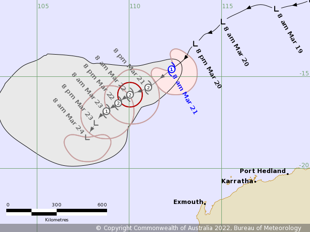
BoM命名00Z命名
IDW24000
Australian Bureau of Meteorology
Tropical Cyclone Warning Centre
TROPICAL CYCLONE INFORMATION BULLETIN
Issued at 8:48 am WST on Monday 21 March 2022
A Tropical Low was located at 8:00 am AWST near 14.6S 112.3E, that is 840 km
north northwest of Exmouth, and moving southwest at 17 kilometres per hour.
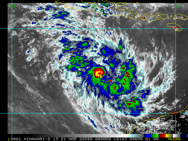
Tropical Cyclone Charlotte located in the Indian Ocean well to the north
northwest of Western Australia and is continuing to develop.
Charlotte is expected to continue to move to the southwest and stay well
offshore from the Australian mainland. From later on Tuesday the environment
becomes less favourable and Charlotte is forecast to begin weakening over the
open ocean.
This system is not expected to impact the Australian mainland in the next four
days.
The next Information Bulletin will be issued at 3 pm AWST.
IDW27600
TROPICAL CYCLONE TECHNICAL BULLETIN: AUSTRALIA - WESTERN REGION
Issued by AUSTRALIAN BUREAU OF METEOROLOGY TROPICAL CYCLONE WARNING CENTRE
at: 0148 UTC 21/03/2022
Name: Tropical Cyclone Charlotte
Identifier: 28U
Data At: 0000 UTC
Latitude: 14.6S
Longitude: 112.3E
Location Accuracy: within 35nm (65 km)
Movement Towards: southwest (222 deg)
Speed of Movement: 9 knots (17 km/h)
Maximum 10-Minute Wind: 40 knots (75 km/h)
Maximum 3-Second Wind Gust: 55 knots (100 km/h)
Central Pressure: 996 hPa
Radius of 34-knot winds NE quadrant: 70 nm (130 km)
Radius of 34-knot winds SE quadrant: 90 nm (165 km)
Radius of 34-knot winds SW quadrant: 70 nm (130 km)
Radius of 34-knot winds NW quadrant:
Radius of 48-knot winds NE quadrant:
Radius of 48-knot winds SE quadrant:
Radius of 48-knot winds SW quadrant:
Radius of 48-knot winds NW quadrant:
Radius of 64-knot winds: nm ( km)
Radius of Maximum Winds: 30 nm (55 km)
Dvorak Intensity Code: T3.0/3.0/D1.0/24HRS STT:D0.5/06HRS
Pressure of outermost isobar: 1006 hPa
Radius of outermost closed isobar: 90 nm (165 km)
FORECAST DATA
Date/Time : Location : Loc. Accuracy: Max Wind : Central Pressure
(UTC) : degrees : nm (km): knots(km/h): hPa
+06: 21/0600: 15.2S 111.6E: 050 (095): 045 (085): 993
+12: 21/1200: 15.6S 111.0E: 060 (115): 050 (095): 989
+18: 21/1800: 15.8S 110.4E: 070 (125): 050 (095): 989
+24: 22/0000: 16.0S 110.0E: 075 (140): 055 (100): 985
+36: 22/1200: 16.4S 109.4E: 085 (160): 050 (095): 988
+48: 23/0000: 16.9S 108.8E: 100 (180): 040 (075): 995
+60: 23/1200: 17.5S 108.2E: 125 (235): 035 (065): 998
+72: 24/0000: 18.3S 107.7E: 155 (290): 035 (065): 998
+96: 25/0000: 21.4S 107.8E: 235 (435): 035 (065): 998
+120: 26/0000: 25.7S 110.0E: 310 (580): 040 (075): 996
REMARKS:
Tropical Cyclone Charlotte has developed over waters well north WA
Recent microwave passes and EIR imagery give good confidence in position, which
matches forecast persistence. Recent imagery shows competing convection to the
south of the system weakening, and convection near the centre intensifying.
Dvorak analysis: DT=3.0 based on curved band pattern with a wrap of 0.7. 24hr
trend D gives MET=3, and PAT agrees. FT/CI=3.0. NOAA ADT has CI of 2.8 (Raw
3.4) and 41 kn 1-minute winds. There is no other objective guidance available
at present. Recent SMAP image (2214UTC) has gales in all but the NW quadrant,
and possible storm force winds in the SE quadrant. Intensity is set at 40 kn
10-minute winds in the SW/SE/NE quadrants.
Charlotte has been moving to the southwest at about 9 knots under the influence
of a mid-level high to the southeast. It is forecast to continue to move to the
southwest for the next 72 hours.
The system is under the influence of low shear, less than 15 knots
northeasterly. SSTs 29 to 30 degrees along the forecast track in the short to
medium term. Upper winds indicate good outflow to the south and strong upper
divergence present. Therefore, Charlotte is expected to intensify further and
should reach category 2 intensity. However, there is some disagreement between
numerical model guidance on how strong Charlotte will become. The GFS and the
ACCESS-G indicate a very intense tropical cyclone compared to the weaker EC and
UK. All models indicate the environment becomes less favourable in the longer
term as the system approaches a near stationary upper trough to the southwest.
Shear is forecast to increase over Charlotte with models also indicating dry
air entrainment late on Tuesday.
In the long-term, the upper low becomes the dominant steering influence, and
the system is forecast to take a more southerly track. As the system interacts
with the upper low we may see baroclinic influences increase. Hence, transition
to a sub-tropical or extra tropical system is possible. There is large
uncertainty associated with this longer term forecast at this stage.
Copyright Commonwealth of Australia
==
The next bulletin for this system will be issued by: 21/0730 UTC. 

Time (AWST) Intensity Category Latitude
(decimal deg.) Longitude
(decimal deg.) Estimated Position
Accuracy (km)
0hr 8 am March 21 1 14.6S 112.3E 65
+6hr 2 pm March 21 1 15.2S 111.6E 95
+12hr 8 pm March 21 2 15.6S 111.0E 115
+18hr 2 am March 22 2 15.8S 110.4E 125
+24hr 8 am March 22 2 16.0S 110.0E 140
+36hr 8 pm March 22 2 16.4S 109.4E 160
+48hr 8 am March 23 1 16.9S 108.8E 180
+60hr 8 pm March 23 tropical low 17.5S 108.2E 235
+72hr 8 am March 24 tropical low 18.3S 107.7E 290
|
|