開啟輔助訪問
 找回密碼
 立即加入

12E.Kay 強度升C2 沿墨西哥西岸北上

簽到天數: 601 天

[LV.9]以壇為家II

2022-9-5 10:35 | 顯示全部樓層
本帖最後由 霧峰追風者 於 2022-9-8 10:28 編輯

基本資料  
編號    :12 E
擾動編號日期:2022 09 02 08
撤編日期  :2022 09 00 00
93E.INVEST.20kts-1008mb-12.9N-94.6W
20220901.2340.goes-17.ir.93E.INVEST.20kts.1008mb.12.9N.94.6W.100pc.jpg
1. South of Southern Mexico:
Disorganized showers and thunderstorms extending several hundred
miles south of the coast of southern Mexico are associated with a
tropical wave and broad area of low pressure.  Gradual development
of this system is expected, and a tropical depression is likely to
form this weekend or early next week while it moves westward and
then west-northwestward near the coast of southern and southwestern
Mexico.  Interests in southern and southwestern Mexico should
monitor the progress of this system.
* Formation chance through 48 hours...medium...40 percent.
* Formation chance through 5 days...high...80 percent
.

two_pac_2d1.png

評分

參與人數 1水氣能量 +15 +1 收起 理由
t02436 + 15 + 1

查看全部評分

回復

使用道具 舉報

簽到天數: 601 天

[LV.9]以壇為家II

霧峰追風者|2022-9-5 10:37 | 顯示全部樓層
009
WTPZ42 KNHC 042036
TCDEP2

Tropical Storm Kay Discussion Number   2
NWS National Hurricane Center Miami FL       EP122022
400 PM CDT Sun Sep 04 2022

Satellite data indicate that the depression has strengthened into
Tropical Storm Kay.  Although the convective pattern is still a bit
ragged, banding features have improved on the south side of the
cyclone. A pair of ASCAT passes from a few hours ago showed peak
winds around 35 kt to the northeast of the center.  Based on that
data and the T2.5 Dvorak classification from TAFB, the initial
intensity is increased a little to 35 kt.  Kay is a large storm with
its cloud field extending several hundred miles across, and some of
the outer bands are moving across the coast of southwestern Mexico.

The center is located a little to the north of the previous track,
and the estimated motion is now 290/11 kt. This general motion is
expected to continue for the next couple of days, keeping the core
of the system south of the coast of southwestern Mexico during that
time.  Thereafter, the models all show a turn to the northwest and
then the north.  Overall, there has been little change in the model
guidance this cycle and the solutions remain relatively tightly
clustered.  Despite the tightly-clustered guidance, the GFS and
ECMWF ensemble spreads encompass as far east as the Gulf of
California and as far west as a few hundred miles west of the Baja
California peninsula.  The NHC track forecast is a little to the
north of the previous one in the short term, due to the initial
position and motion, but ends up close to the previous track beyond
48 h.

Kay is likely to strengthen during the next few days while it
remains over warm water and embedded in a very moist environment.
Although the Rapid Intensification Indices in the SHIPS model are
relatively high, rapid intensification in the short term appears
unlikely given the broad structure of the cyclone and expected
moderate shear.  The new NHC intensity forecast is largely
consistent with the previous one and shows steady strengthening
during the next 2 to 3 days.  Beyond that time, weakening is
expected due to cooler SSTs.  Regardless of the details, Kay is
expected to be a significant hurricane near Baja in a few days.

KEY MESSAGES:

1. Although Kay is expected to stay offshore, heavy rainfall could
lead to localized flash flooding in portions of southwestern Mexico.

2. Interests in the Baja California peninsula should closely monitor
Kay as tropical storm or hurricane watches could be required tonight
or on Monday.


FORECAST POSITIONS AND MAX WINDS

INIT  04/2100Z 14.8N 102.5W   35 KT  40 MPH
12H  05/0600Z 15.1N 104.1W   45 KT  50 MPH
24H  05/1800Z 15.6N 106.0W   55 KT  65 MPH
36H  06/0600Z 16.4N 107.8W   65 KT  75 MPH
48H  06/1800Z 17.6N 109.5W   75 KT  85 MPH
60H  07/0600Z 19.2N 110.9W   85 KT 100 MPH
72H  07/1800Z 21.1N 112.0W   85 KT 100 MPH
96H  08/1800Z 24.9N 113.6W   75 KT  85 MPH
120H  09/1800Z 28.3N 115.5W   55 KT  65 MPH

$$
Forecaster Cangialosi
203753_5day_cone_with_line_and_wind.png 20222472000_GOES16-ABI-FL-GEOCOLOR-EP122022-2000x2000.jpg
回復

使用道具 舉報

簽到天數: 601 天

[LV.9]以壇為家II

霧峰追風者|2022-9-8 10:26 | 顯示全部樓層
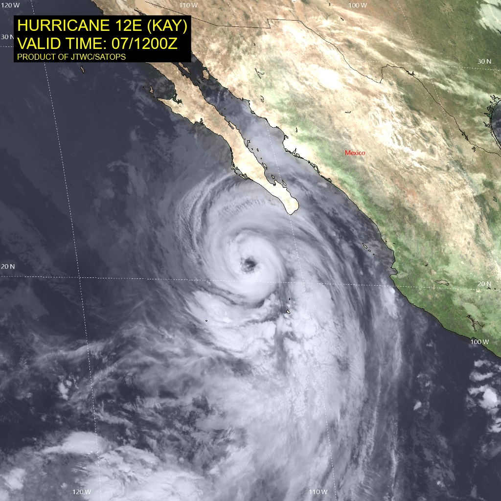
000
WTPZ42 KNHC 071510 CCA
TCDEP2

Hurricane Kay Discussion Number  13...Corrected
NWS National Hurricane Center Miami FL       EP122022
900 AM MDT Wed Sep 07 2022

Corrected first Key Message

Kay appears to be on a strengthening trend. Satellite images
indicate that the hurricane has a large eye, with a diameter of
about 25 n mi, and a nearly symmetric eyewall. There are some dry
slots between the eyewall and rainbands, however. The subjective
satellite intensity estimates from TAFB and SAB have increased to
T5.0/90 kt, and the initial intensity is raised to 90 kt based on
that data. This intensity estimate is below the latest ADT values
from CIMSS at the University of Wisconsin, so it is possible that
Kay could be a little stronger. An Air Force Hurricane Hunter
aircraft is en route to investigate Kay this afternoon, and the data
the plane collects will be very helpful in assessing the intensity
and structure of the hurricane.

Kay will likely strengthen a little more, and it could become
a major hurricane while it remains in conducive environmental
conditions today. However, by early tomorrow, the hurricane is
expected to move over sub 26 C SSTs and move over progressively
cooler waters during the following few days. The cooler SSTs and
drier air should cause a steady weakening trend later this week
and this weekend. The NHC intensity forecast is a little higher
than the previous one in the short term, and lies at the high end of
the guidance during the first few days of the forecast.

The hurricane is moving north-northwestward, and that motion should
continue for the next couple of days taking the core of Kay very
near or over the west-central Baja California peninsula on Thursday
and Friday. After that time, when Kay moves close to northern Baja,
a turn to the left is expected as the shallow system becomes steered
by the flow on the south side of a low- to mid-level ridge. The
model guidance is in fairly good agreement, and the NHC track
forecast is essentially the same as the previous one and close to
the various consensus models.

Kay is a very large tropical cyclone. It is producing an extensive
area of high seas, with swells affecting portions of southwestern
Mexico and the southern Baja California peninsula. Although Kay is
likely to weaken before it makes landfall or moves very close to the
west-central coast of the Baja peninsula, it is forecast to remain a
large and dangerous hurricane through that time. In addition, high
wind, surf, and rainfall impacts will extend far from the center so
users should not focus on the exact forecast track.

KEY MESSAGES:

1. Heavy rainfall could lead to flash flooding, including
landslides, across the Baja California peninsula and portions of
mainland northwestern Mexico through Saturday morning.  Flash and
urban flooding is possible across the peninsular ranges of southern
California and southwestern Arizona Friday night into Saturday.

2. Hurricane conditions are expected along portions of the
west-central Baja California coast on Thursday and Thursday night,
and a hurricane warning is in effect for that area.

3. Tropical storm conditions are beginning over portions of the
Baja California peninsula, and these conditions are expected
to spread northward during the next day or so, where a
Tropical Storm Warning is in effect.


FORECAST POSITIONS AND MAX WINDS

INIT  07/1500Z 21.1N 112.6W   90 KT 105 MPH
12H  08/0000Z 22.7N 113.3W   95 KT 110 MPH
24H  08/1200Z 24.9N 114.0W   85 KT 100 MPH
36H  09/0000Z 27.2N 115.0W   75 KT  85 MPH
48H  09/1200Z 28.9N 116.1W   65 KT  75 MPH
60H  10/0000Z 30.2N 117.5W   50 KT  60 MPH
72H  10/1200Z 30.9N 118.9W   40 KT  45 MPH
96H  11/1200Z 30.9N 121.2W   30 KT  35 MPH...POST-TROP/REMNT LOW
120H  12/1200Z 29.4N 121.9W   20 KT  25 MPH...POST-TROP/REMNT LOW

$$

Forecaster Cangialosi
12E_071200sair.jpg
回復

使用道具 舉報

快速回覆
您需要登錄後才可以回帖 登錄 | 立即加入

本版積分規則

本平台僅供學術討論之用,預報應以氣象局為準

威普網站虛擬主機贊助公司

臺灣第一個天氣類型社群平台 即時天氣資訊、精準颱風動態

線上客服
FB傳送訊息
廣告行銷
精準行銷 物超所值
官方粉專
發佈 快速回復 返回頂部 返回列表