開啟輔助訪問
 找回密碼
 立即加入

02E.Amanda→03L.Cristobal 近岸命名即登陸瓜國 後於墨灣再度命名

簽到天數: 1650 天

[LV.Master]伴壇終老

老農民版夜神月|2020-6-1 14:58 | 顯示全部樓層
將跨洋區入北大西洋
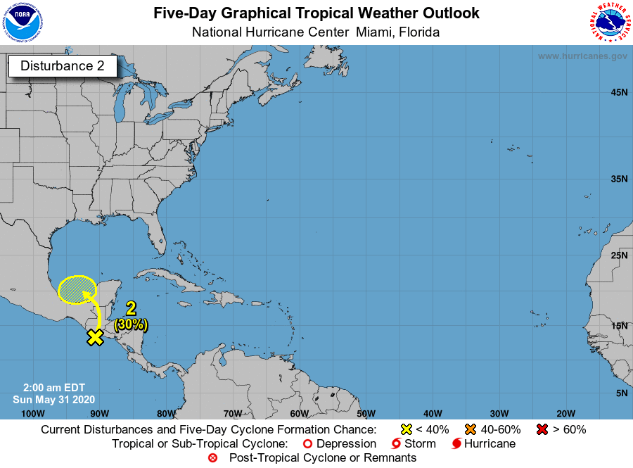
NHC將02E.Amanda重新編號為93L,評級Medium60%/70%
20200601.0610.goes-16.ir.93L.INVEST.25kts.1006mb.17.6N.90W.100pc.jpg two_atl_2d0.png
two_atl_2d1.png two_atl_5d1.png
回復

使用道具 舉報

簽到天數: 1650 天

[LV.Master]伴壇終老

老農民版夜神月|2020-5-31 17:27 | 顯示全部樓層
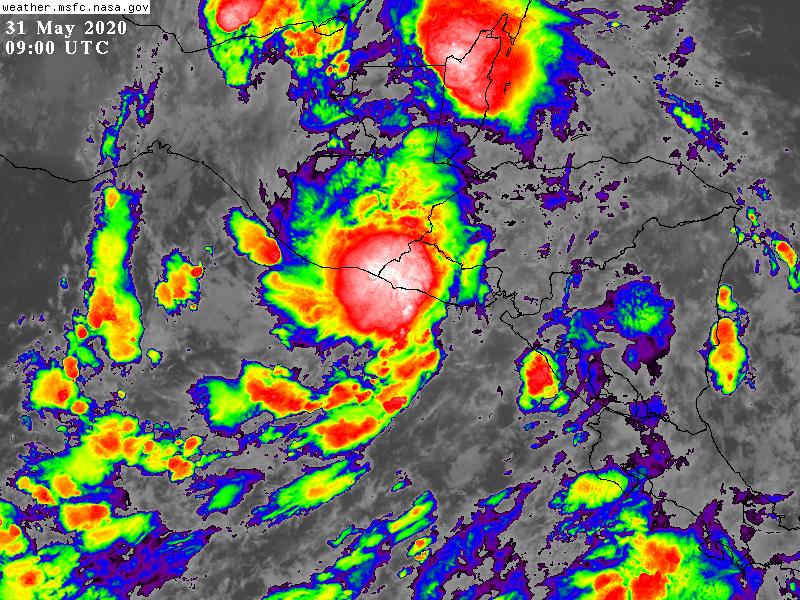
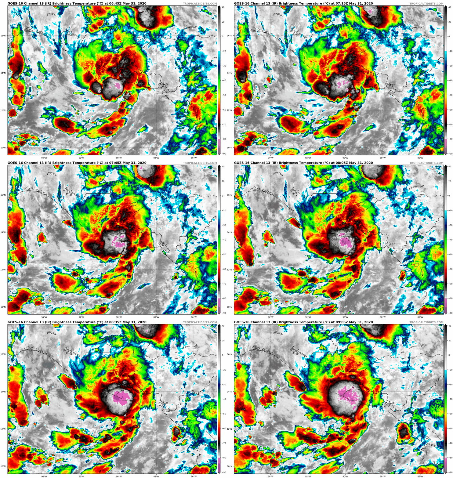
NHC再次近岸命名,02E31/09Z獲名Amanda,定強35KT
並且預測Amanda殘餘有橫越中美洲陸地後進入墨西哥灣再發展的可能
WTPZ42 KNHC 310854
TCDEP2

Tropical Storm Amanda Discussion Number   3
NWS National Hurricane Center Miami FL       EP022020
400 AM CDT Sun May 31 2020

Conventional and scatterometer satellite data indicate that the
depression has once again become better organized after a brief
hiatus a few hours ago. The intensity has been increased to 35 kt
based on recent UW-CIMSS ADT and SATCON satellite intensity
estimates of 34 kt and 38 kt, respectively.

The initial motion estimate is 020/08 kt, which is based on several
passive microwave and ASCAT scatterometer fixes.  Amanda is
embedded within the eastern periphery of a larger cyclonic gyre
centered over eastern Mexico. The cyclone is expected to remain
trapped within the larger gyre for the next few days, resulting in
a north-northeastward to northward motion today, followed by a much
slower northwestward to westward motion on Tuesday and Wednesday,
with the remnant low possibly emerging over the Bay of Campeche on
days 2 and 3. The new forecast track is similar to the previous
advisory through 24 hours, but additional forecast track positions
were added through 72 hours due to the possibility of the system
moving over the Bay of Campeche, which could result in the formation
of a new tropical cyclone.

Little change in strength is expected before landfall occurs. After
landfall, the cyclone is expected to rapidly weaken over the
mountains of Central America.  However, the large size of the
circulation could still produce winds of 20-25 kt over the adjacent
waters of the eastern North Pacific, Gulf of Honduras, and the Bay
of Campeche for the next 2-3 days.

The main hazards from Amanda, and the larger gyre in which the
cyclone is embedded, are expected to be heavy rainfall and flooding.
Amanda's slow forward motion, large size, and abundant tropical
moisture could cause life-threatening flash floods and mudslides
across portions of Central America and southern Mexico, and these
threats will continue well after Amanda moves inland.  For
additional information, see products issued by your national
meteorological service.


FORECAST POSITIONS AND MAX WINDS

INIT  31/0900Z 13.8N  90.4W   35 KT  40 MPH
12H  31/1800Z 15.2N  90.1W   25 KT  30 MPH...INLAND
24H  01/0600Z 17.4N  90.3W   20 KT  25 MPH...POST-TROP/INLAND
36H  01/1800Z 18.7N  91.4W   20 KT  25 MPH...POST-TROP/INLAND
48H  02/0600Z 19.0N  92.7W   20 KT  25 MPH...POST-TROPICAL
60H  02/1800Z 18.8N  93.2W   20 KT  25 MPH...POST-TROPICAL
72H  03/0600Z 18.4N  93.7W   20 KT  25 MPH...POST-TROPICAL
96H  04/0600Z...DISSIPATED

$$
Forecaster Stewart
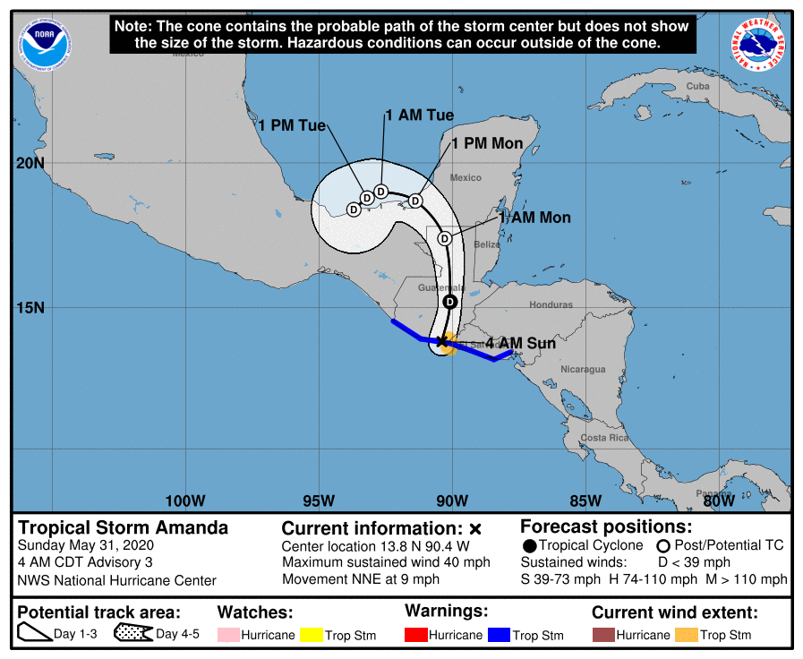
085849_5day_cone_with_line_and_wind.png
GOES09002020152jFHkjN.jpg two_atl_5d2.png
goes16_ir_02E_202005310645.gif
回復

使用道具 舉報

簽到天數: 3279 天

[LV.Master]伴壇終老

t02436|2020-5-31 10:25 | 顯示全部樓層
21Z升格02E,即將登陸,不看好發展
932
WTPZ42 KNHC 302038
TCDEP2

Tropical Depression Two-E Discussion Number   1
NWS National Hurricane Center Miami FL       EP022020
400 PM CDT Sat May 30 2020

Satellite data indicate that the low pressure system that NHC has
been monitoring near the coasts of Guatemala and El Salvador has
developed sufficiently organized deep convection and a well-defined
center to be classified a tropical depression.  It should be noted
that this depression is embedded within a large gyre that is spread
out across the far eastern Pacific and portions of Central America.
The initial intensity is set at 25 kt, following the maximum wind
observed in recent ASCAT passes and a Dvorak classification from
TAFB.  The depression could strengthen a little before it reaches
the coast of Guatemala early Sunday, but significant strengthening
is not expected given the broad structure of the cyclone and its
limited time over water.  A tropical storm warning has been issued
by the governments of Guatemala and El Salvador for the entire
coastline of those countries.

The initial motion of the depression is estimated to be 030/3 kt,
but this is highly uncertain given that the center of the system
has only recently become well defined.  The track models are in
fairly good agreement that a slow northward or north-northeastward
should occur through landfall, and the cyclone is expected to
dissipate over the rugged terrain of Guatemala late Sunday or
Sunday night.

The main hazard from the system, and the larger gyre, is expected to
be heavy rainfall.  The depression's slow forward motion, large
size, and abundant tropical moisture could cause life-threatening
flash floods and mudslides across portions of Central America and
southern Mexico.  For additional information, see products
issued by your national meteorological service.

FORECAST POSITIONS AND MAX WINDS

INIT  30/2100Z 12.3N  91.1W   25 KT  30 MPH
12H  31/0600Z 13.2N  90.9W   30 KT  35 MPH
24H  31/1800Z 15.0N  90.5W   25 KT  30 MPH...INLAND
36H  01/0600Z...DISSIPATED

$$
Forecaster Cangialosi

233914_5day_cone_with_line.png

GOES02102020152XkSRHK.jpg
回復

使用道具 舉報

簽到天數: 1650 天

[LV.Master]伴壇終老

老農民版夜神月|2020-5-31 02:08 | 顯示全部樓層
NHC提升評級為High,80%/80%
1. Satellite images indicate that showers and thunderstorms associated
with the low pressure system located just off the coasts of
Guatemala and El Salvador continue to become better organized.  If
the current trend continues, advisories could be initiated on this
system later today or tonight. Interests in El Salvador, Guatemala,
and southern Mexico should closely monitor the progress of this
system as it is expected to move across those locations tonight and
Sunday.  

Regardless of development, this slow moving disturbance is expected
to produce heavy rainfall over portions of Central America and
southern Mexico during the next few days.  These rains could cause
life-threatening flash floods and mudslides, especially in areas of
mountainous terrain.  See products from your local national
meteorological service for additional information.
* Formation chance through 48 hours...high...80 percent.
* Formation chance through 5 days...high...80 percent.

two_pac_2d1.png two_pac_5d1.png
014959we533fz18gb3fnfj.jpg goes16_ir_91E_202005301525.gif
回復

使用道具 舉報

簽到天數: 1650 天

[LV.Master]伴壇終老

老農民版夜神月|2020-5-30 08:07 | 顯示全部樓層
JTWC29/2200Z發布TCFA
WTPN21 PHNC 292200
MSGID/GENADMIN/JOINT TYPHOON WRNCEN PEARL HARBOR HI//
SUBJ/TROPICAL CYCLONE FORMATION ALERT (INVEST 91E)//
RMKS/
1. FORMATION OF A SIGNIFICANT TROPICAL CYCLONE IS POSSIBLE WITHIN
125 NM EITHER SIDE OF A LINE FROM 10.8N 91.6W TO 13.7N 92.5W
WITHIN THE NEXT 12 TO 24 HOURS. AVAILABLE DATA DOES NOT JUSTIFY
ISSUANCE OF NUMBERED TROPICAL CYCLONE WARNINGS AT THIS TIME.
WINDS IN THE AREA ARE ESTIMATED TO BE 20 TO 25 KNOTS. METSAT
IMAGERY AT 292200Z INDICATES THAT A CIRCULATION CENTER IS LOCATED
NEAR 11.0N 91.7W. THE SYSTEM IS MOVING NORTHWARD AT 05 KNOTS.
2. REMARKS: AN AREA OF CONVECTION (INVEST 91E) HAS PERSISTED NEAR
11.0N  91.7W, APPROXIMATELY 1878 NM SOUTHEAST OF SAN DIEGO. ANIMATED
ENHANCED INFRARED SATELLITE IMAGERY DEPICTS A BROAD, DISORGANIZED
CIRCULATION WITH FLARING CONVECTION. 91E IS CURRENTLY IN AN
ENVIRONMENT FAVORABLE FOR DEVELOPMENT WITH LOW VERTICAL WIND SHEAR
(<15 KNOTS), GOOD EQUATORWARD OUTFLOW ALOFT, AND WARM (29-30C) SEA
SURFACE TEMPERATURES. GLOBAL MODELS INDICATE 91E WILL TRACK
NORTHWARD TOWARDS MEXICO WITH SLOW INTENSIFICATION. MAXIMUM
SUSTAINED SURFACE WINDS ARE ESTIMATED AT 20 TO 25 KNOTS. MINIMUM SEA
LEVEL PRESSURE IS ESTIMATED TO BE NEAR 1004 MB. THE POTENTIAL FOR
THE DEVELOPMENT OF A SIGNIFICANT TROPICAL CYCLONE WITHIN THE NEXT 24
HOURS IS HIGH.
3. THIS ALERT WILL BE REISSUED, UPGRADED TO WARNING OR CANCELLED BY
302200Z.//
NNNN

ep9120.gif goes16_truecolor_91E_202005292125.gif
91E_gefs_latest.png GOES23502020150isWw5U.jpg

回復

使用道具 舉報

12
快速回覆
您需要登錄後才可以回帖 登錄 | 立即加入

本版積分規則

本平台僅供學術討論之用,預報應以氣象局為準

威普網站虛擬主機贊助公司

臺灣第一個天氣類型社群平台 即時天氣資訊、精準颱風動態

線上客服
FB傳送訊息
廣告行銷
精準行銷 物超所值
官方粉專
發佈 快速回復 返回頂部 返回列表