開啟輔助訪問
 找回密碼
 立即加入

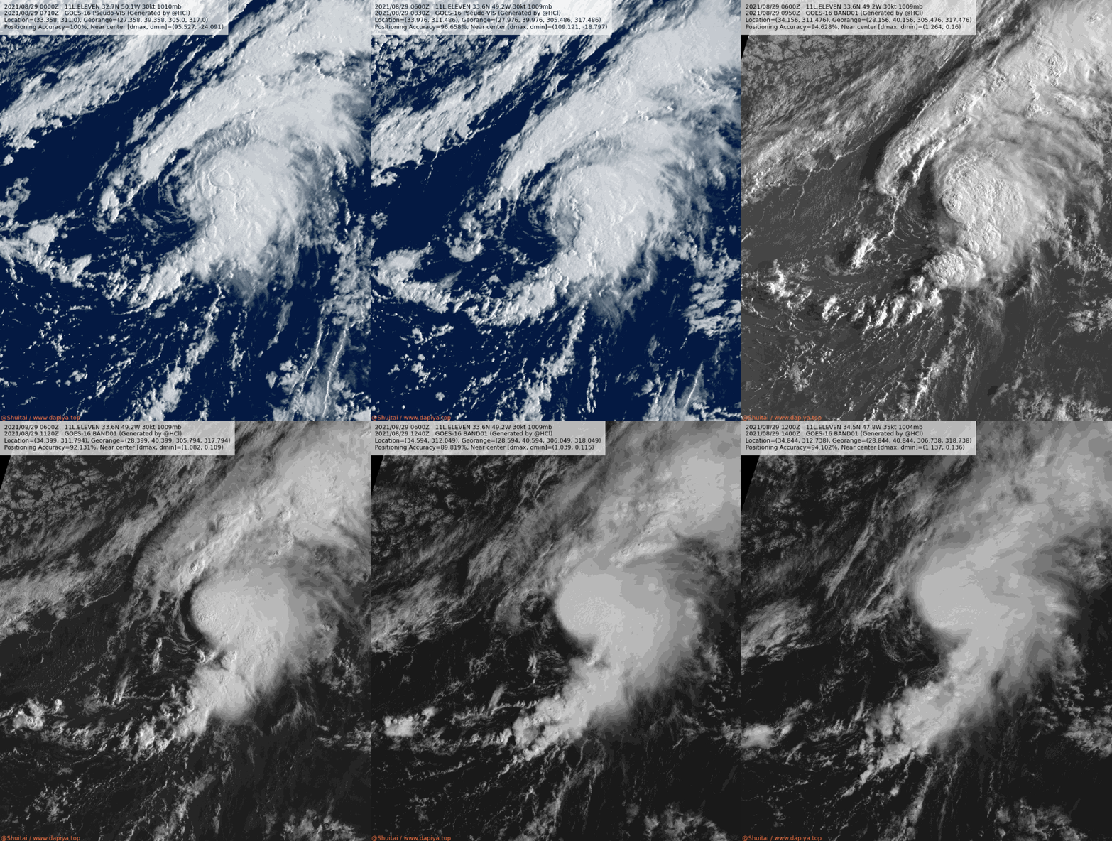
11L.Julian 轉化溫氣

簽到天數: 1650 天

[LV.Master]伴壇終老

2021-8-23 23:03 | 顯示全部樓層
  熱帶風暴  
編號:11 L
名稱:Julian
20210829.1700.goes-16.vis.2km.11L.JULIAN.45kts.998mb.34.5N.47.8W.pc.jpg
  基本資料  
擾動編號日期:2021 08 21 22
命名日期  :2021 08 29 23
撤編日期  :2021 08 31 14
登陸地點  :


  巔峰時期資料  
近中心最強風速 :45  kt (
TS )
海平面最低氣壓 :998 百帕

  擾動編號資料  

97L.INVEST.25kts.1009mb.16.9N.38W 20210823.1440.goes-16.ir.97L.INVEST.25kts.1009mb.16.9N.38W.100pc.jpg

  NHC:0%  
1. A broad low pressure system is producing disorganized showers and
thunderstorms over the eastern tropical Atlantic more than 700 miles
west of the Cabo Verde Islands.  Little development is expected  
during the next couple of days due to only marginally conducive
ocean temperatures.  Thereafter, however, some gradual development
is possible by the middle to latter part of the week while the
system moves northwestward at 10 to 15 mph over the central
Atlantic.
* Formation chance through 48 hours...low...near 0 percent.
* Formation chance through 5 days...low...30 percent.

two_atl_2d1 (30).png two_atl_5d1 (31).png
以上資料來自:NHC、颱風論壇整理製作

評分

參與人數 1水氣能量 +15 +1 收起 理由
t02436 + 15 + 1

查看全部評分

回復

使用道具 舉報

簽到天數: 1650 天

[LV.Master]伴壇終老

老農民版夜神月|2021-8-30 10:49 | 顯示全部樓層
03Z已轉化為溫帶氣旋 024156_5day_cone_no_line_and_wind.png 20210829.2240.goes-16.ir.11L.JULIAN.50kts.995mb.36N.45.6W.100pc.jpg
20210829.2249.mta.ASCAT.wind.11L.JULIAN.50kts-995mb.373N.428W.25km.noqc.jpeg

380
WTNT41 KNHC 300246
TCDAT1

Post-Tropical Cyclone Julian Discussion Number   5
NWS National Hurricane Center Miami FL       AL112021
300 AM GMT Mon Aug 30 2021

Julian has been showing signs of a transition into an extratropical
cyclone over the past several hours. The deep convection has become
detached to the northeast from the low-level center and cloud tops
of that convection are warming. A line of convection to the south of
the center resembles a frontal boundary, with recent scatterometer
data showing a notable wind shift along that line. Based on the
structural changes noted above, as well as a majority of FSU
phase-space diagrams from the various global models, Julian is
estimated to have transitioned to an extratropical cyclone. Recent
ASCAT data showed the cyclone's intensity remains 50 kt. The cyclone
is forecast to maintain this intensity through Monday before
weakening. It is then forecast to dissipate in a few days over the
northern Atlantic. The system should continue to move quickly
northeastward through Monday, then turn northward and northwestward
Monday night into Tuesday.

This is the last advisory on Julian by the National Hurricane
Center. Additional information on this system can be found in High
Seas Forecasts issued by the National Weather Service, under AWIPS
header NFDHSFAT1, WMO header FZNT01 KWBC, and online at
ocean.weather.gov/shtml/NFDHSFAT1.php


FORECAST POSITIONS AND MAX WINDS

INIT  30/0300Z 38.1N  41.9W   50 KT  60 MPH...POST-TROPICAL
12H  30/1200Z 40.3N  39.0W   50 KT  60 MPH...POST-TROP/EXTRATROP
24H  31/0000Z 44.1N  36.4W   50 KT  60 MPH...POST-TROP/EXTRATROP
36H  31/1200Z 48.5N  36.2W   45 KT  50 MPH...POST-TROP/EXTRATROP
48H  01/0000Z 53.0N  38.2W   40 KT  45 MPH...POST-TROP/EXTRATROP
60H  01/1200Z 57.0N  40.0W   40 KT  45 MPH...POST-TROP/EXTRATROP
72H  02/0000Z...DISSIPATED

$$
Forecaster Latto
回復

使用道具 舉報

簽到天數: 1650 天

[LV.Master]伴壇終老

老農民版夜神月|2021-8-30 00:21 | 顯示全部樓層
本帖最後由 老農民版夜神月 於 2021-8-30 00:22 編輯

NHC表示由於ASCAT風場掃出40節風旗,故升格並定強45節
A 1246 UTC ASCAT-B pass revealed an area
of winds over 40 kt southeast of the center, so the system is
upgraded to Tropical Storm Julian with maximum winds of 45 kt.

20210829.1247.mtb.ASCAT.wind.11L.ELEVEN.35kts-1004mb.345N.478W.25km.noqc.jpeg 20210829.1247.mtb.ASCAT.wind.11L.JULIAN.45kts-998mb.345N.478W.25km.jpeg
20210829.1036.f17.91pct91h91v.11L.ELEVEN.30kts.1009mb.33.6N.49.2W.075pc.jpg 11L_RBTOP.gif
回復

使用道具 舉報

簽到天數: 3280 天

[LV.Master]伴壇終老

t02436|2021-8-29 23:18 | 顯示全部樓層
15Z評價45節,命名Julian,+72後消散。
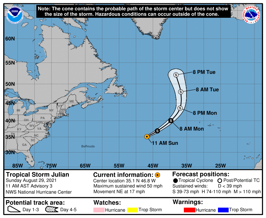
145418_5day_cone_with_line.png
000
WTNT41 KNHC 291453
TCDAT1

Tropical Storm Julian Discussion Number   3
NWS National Hurricane Center Miami FL       AL112021
1100 AM AST Sun Aug 29 2021

The system has become better organized this morning, with the
low-level center located on the southwestern edge of a persistent
mass of deep convection.  A 1246 UTC ASCAT-B pass revealed an area
of winds over 40 kt southeast of the center, so the system is
upgraded to Tropical Storm Julian with maximum winds of 45 kt.

Julian is accelerating toward the northeast (045/15 kt) in the flow
to the south of a deep-layer area of low pressure located just east
of Newfoundland.  The storm is expected to move around the
southeastern and eastern periphery of this large low during the next
few days, accelerating further and turning toward the north by 48
hours.  The track models are all in good agreement on this scenario,
and the NHC track forecast is very close to the TVCA and HCCA
consensus aids.  This new forecast is also relatively unchanged from
the previous advisory.

Winds in the storm have increased faster than expected, even in the
face of 20 kt of west-southwesterly shear.  This shear is forecast
to increase substantially in the coming days, with SHIPS diagnostics
indicating it may reach magnitudes of 40-50 kt. However, the storm
will still be moving over marginally warm waters around 26 degrees
Celsius, and its fast motion and some baroclinic forcing could allow
for additional strengthening during the next 12-24 hours.  Nearly
all the intensity models support some strengthening, and the NHC
official forecast peaks the winds at 55 kt in 24 hours, roughly
between the IVCN and HCCA solutions. Phase-space diagrams suggest
that Julian will probably already be going through extratropical
transition at that time, and it should be fully extratropical by 36
hours.  Gradual weakening is anticipated after 24 hours, and the
extratropical low is likely to dissipate over the north Atlantic by
day 3.


FORECAST POSITIONS AND MAX WINDS

INIT  29/1500Z 35.1N  46.8W   45 KT  50 MPH
12H  30/0000Z 36.9N  43.7W   50 KT  60 MPH
24H  30/1200Z 40.0N  39.7W   55 KT  65 MPH
36H  31/0000Z 43.6N  37.0W   50 KT  60 MPH...POST-TROP/EXTRATROP
48H  31/1200Z 48.0N  36.8W   45 KT  50 MPH...POST-TROP/EXTRATROP
60H  01/0000Z 52.2N  38.2W   40 KT  45 MPH...POST-TROP/EXTRATROP
72H  01/1200Z...DISSIPATED

$$
Forecaster Berg
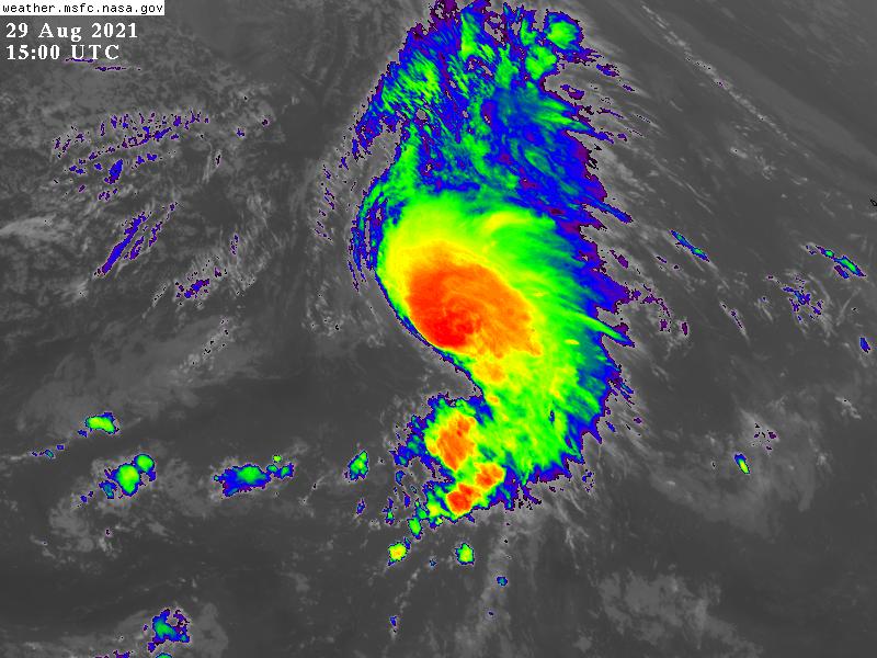
GOES150020212418X7tnv.jpg

11L_BAND01.gif
回復

使用道具 舉報

簽到天數: 1650 天

[LV.Master]伴壇終老

老農民版夜神月|2021-8-29 11:00 | 顯示全部樓層
首報上望45KT,而後轉化為溫帶氣旋
FORECAST POSITIONS AND MAX WINDS

INIT  29/0300Z 33.0N  49.7W   30 KT  35 MPH
12H  29/1200Z 34.6N  47.1W   35 KT  40 MPH
24H  30/0000Z 36.8N  43.4W   45 KT  50 MPH
36H  30/1200Z 39.5N  39.2W   50 KT  60 MPH...POST-TROP/EXTRATROP
48H  31/0000Z 43.4N  36.4W   45 KT  50 MPH...POST-TROP/EXTRATROP
60H  31/1200Z 47.9N  36.3W   40 KT  45 MPH...POST-TROP/EXTRATROP
72H  01/0000Z...DISSIPATED

024942_5day_cone_no_line_and_wind.png goes16_vis_97L.gif goes16_rainbow_97L.gif
回復

使用道具 舉報

簽到天數: 1650 天

[LV.Master]伴壇終老

老農民版夜神月|2021-8-29 10:16 | 顯示全部樓層
NHC升格11L
網頁擷取_29-8-2021_101437_rammb-data.cira.colostate.edu.jpeg 97L_BAND01.gif 20210828.1628.gw1.89pct89h89v.97L.INVEST.25kts.1012mb.32.5N.52.3W.87pc.jpg
回復

使用道具 舉報

簽到天數: 1650 天

[LV.Master]伴壇終老

老農民版夜神月|2021-8-29 03:23 | 顯示全部樓層
FWC-N發布TCFA
OTTUZYUW RHOIAAA0001 2382043-UUUU--RHSSSUU.
ZNR UUUUU
O 281900Z AUG 21
FM FLEWEACEN NORFOLK VA
TO HURRIWARNLANT
INFO FLEWEACEN NORFOLK VA
FLEWEACEN SAN DIEGO CA
JOINT TYPHOON WRNCEN PEARL HARBOR HI
BT
UNCLAS
SUBJ/TROPICAL CYCLONE FORMATION ALERT (97L)//
WTNT21 KNGU 281900
RMKS/1. FORMATION OF A SIGNIFICANT TROPICAL CYCLONE IS POSSIBLE WITHIN 100 NM EITHER SIDE OF A LINE FROM 32.3N 51.6W TO 37.5N
46.4W WITHIN THE NEXT 24 HOURS. AVAILABLE DATA DOES NOT JUSTIFY
ISSUANCE OF NUMBERED TROPICAL CYCLONE WARNINGS AT THIS TIME.
WINDS IN THE AREA ARE ESTIMATED TO BE 20 TO 25 KNOTS. METSAT
IMAGERY, SYNOPTIC DATA AND RADAR DATA AT 280300Z INDICATE THAT
A CIRCULATION CENTER IS LOCATED NEAR 32.3N 51.6W. THE SYSTEM IS
MOVING NORTHEASTWARD AT 16 KNOTS.
2.SHOWERS AND THUNDERSTORMS CONTINUE TO SHOW SIGNS OF ORGANIZATION IN ASSOCIATION WITH AN AREA OF LOW PRESSURE LOCATED OVER THE CENTRAL ATLANTIC. IN ADDITION, SATELLITE WIND DATA INDICATE THAT THE CIRCULATION HAS BECOME A LITTLE BETTER DEFINED. ALTHOUGH ENVIRONMENTAL CONDITIONS REMAIN ONLY MARGINALLY CONDUCTIVE FOR FURTHER DEVELOPMENT, ONLY A SLIGHT INCREASE IN ORGANIZATION WOULD RESULT IN THE FORMATION OF A TROPICAL DEPRESSION LATER TODAY OR TONIGHT. IN A COUPLE OF DAYS, THE SYSTEM IS FORECAST TO BE ABSORBED BY A FRONTAL SYSTEM. THE DISTURBANCE IS EXPECTED TO
DRIFT EASTWARD THROUGH TODAY, THEN ACCELERATE NORTHEASTWARD
SUNDAY TOWARD THE CENTRAL NORTH ATLANTIC.
3. THIS ALERT WILL BE REISSUED, UPGRADED TO WARNING OR CANCELLED BY 291900Z.//
BT
#0001
NNNN
al972021.gif
回復

使用道具 舉報

簽到天數: 1650 天

[LV.Master]伴壇終老

老農民版夜神月|2021-8-29 01:58 | 顯示全部樓層
NHC展望一舉提升至High,80%
1. Showers and thunderstorms continue to show signs of organization in
association with an area of low pressure located over the central
Atlantic.  In addition, satellite wind data indicate that the
circulation has become a little better defined. Although
environmental conditions remain only marginally conducive for
further development, only a slight increase in organization would
result in the formation of a tropical depression later today or
tonight.  In a couple of days, the system is forecast to be
absorbed by a frontal system.  The disturbance is expected to drift
eastward through today, then accelerate northeastward Sunday toward
the central north Atlantic.
* Formation chance through 48 hours...high...80 percent.
* Formation chance through 5 days...high...80 percent.
two_atl_2d0 (2).png two_atl_2d1 (3).png
two_atl_5d1 (3).png 20210828.1628.gw1.89pct89h89v.97L.INVEST.25kts.1012mb.32.5N.52.3W.87pc.jpg
回復

使用道具 舉報

12下一頁
快速回覆
您需要登錄後才可以回帖 登錄 | 立即加入

本版積分規則

本平台僅供學術討論之用,預報應以氣象局為準

威普網站虛擬主機贊助公司

臺灣第一個天氣類型社群平台 即時天氣資訊、精準颱風動態

線上客服
FB傳送訊息
廣告行銷
精準行銷 物超所值
官方粉專
發佈 快速回復 返回頂部 返回列表