開啟輔助訪問
 找回密碼
 立即加入

11L.Julian 轉化溫氣

簽到天數: 1650 天

[LV.Master]伴壇終老

2021-8-23 23:03 | 顯示全部樓層
  熱帶風暴  
編號:11 L
名稱:Julian
20210829.1700.goes-16.vis.2km.11L.JULIAN.45kts.998mb.34.5N.47.8W.pc.jpg
  基本資料  
擾動編號日期:2021 08 21 22
命名日期  :2021 08 29 23
撤編日期  :2021 08 31 14
登陸地點  :


  巔峰時期資料  
近中心最強風速 :45  kt (
TS )
海平面最低氣壓 :998 百帕

  擾動編號資料  

97L.INVEST.25kts.1009mb.16.9N.38W 20210823.1440.goes-16.ir.97L.INVEST.25kts.1009mb.16.9N.38W.100pc.jpg

  NHC:0%  
1. A broad low pressure system is producing disorganized showers and
thunderstorms over the eastern tropical Atlantic more than 700 miles
west of the Cabo Verde Islands.  Little development is expected  
during the next couple of days due to only marginally conducive
ocean temperatures.  Thereafter, however, some gradual development
is possible by the middle to latter part of the week while the
system moves northwestward at 10 to 15 mph over the central
Atlantic.
* Formation chance through 48 hours...low...near 0 percent.
* Formation chance through 5 days...low...30 percent.

two_atl_2d1 (30).png two_atl_5d1 (31).png
以上資料來自:NHC、颱風論壇整理製作

評分

參與人數 1水氣能量 +15 +1 收起 理由
t02436 + 15 + 1

查看全部評分

回復

使用道具 舉報

簽到天數: 1650 天

[LV.Master]伴壇終老

老農民版夜神月|2021-8-25 07:42 | 顯示全部樓層
NHC展望已提升至20%/70%
2. A broad trough of low pressure is producing disorganized showers and
thunderstorms over the central tropical Atlantic about 1000 miles
east-northeast of the northern Leeward Islands.  Little development
of this system is expected during the next day or two due to
unfavorable upper-level winds.  Afterwards, environmental conditions
are expected to become more conducive for development, and a
tropical depression is likely to form by the end of the week while
the system turns eastward over the central Atlantic.
* Formation chance through 48 hours...low...20 percent.
* Formation chance through 5 days...high...70 percent.

two_atl_2d2 (7).png two_atl_5d2 (7).png
97L_intensity_latest (1).png
回復

使用道具 舉報

簽到天數: 1650 天

[LV.Master]伴壇終老

老農民版夜神月|2021-8-26 02:09 | 顯示全部樓層
NHC展望提升至Medium,40%/80% two_atl_2d2 (8).png two_atl_5d2 (8).png
20210825.1551.gw1.89pct89h89v.98L.INVEST.25kts.1008mb.10.8N.33.8W.83pc.jpg 97L_geps_latest.png

2. A broad trough of low pressure is producing disorganized showers and
thunderstorms over the central tropical Atlantic about 700 miles
southeast of Bermuda. Only slow development of this system is
expected during the next day or so due to unfavorable upper-level
winds. Afterwards, environmental conditions are forecast to become
more conducive for development, and a tropical depression is likely
to form late this week or this weekend while the system turns
eastward over the open central Atlantic.
* Formation chance through 48 hours...medium...40 percent.
* Formation chance through 5 days...high...80 percent.

回復

使用道具 舉報

簽到天數: 1650 天

[LV.Master]伴壇終老

老農民版夜神月|2021-8-27 07:56 | 顯示全部樓層
本帖最後由 老農民版夜神月 於 2021-8-27 07:58 編輯

NHC展望提升至50%
1. An elongated area of low pressure located over the central Atlantic
about 650 miles east of Bermuda is producing disorganized showers
and thunderstorms.  Environmental conditions are forecast to be
generally conducive for development, and a tropical depression is
likely to form over the weekend.  The system is expected to move
slowly eastward during the next day or two, but a faster
northeastward motion is forecast to begin on Sunday.   
* Formation chance through 48 hours...medium...50 percent.
* Formation chance through 5 days...high...70 percent.

two_atl_2d1 (33).png two_atl_5d1 (34).png
97L_gefs_latest (4).png LATEST (46).jpg
回復

使用道具 舉報

簽到天數: 1650 天

[LV.Master]伴壇終老

老農民版夜神月|2021-8-28 07:45 | 顯示全部樓層
NHC略為調降展望至40%
1. An elongated area of low pressure located over the central Atlantic
several hundred miles east of Bermuda is producing disorganized
showers and a couple of thunderstorms.  Environmental conditions are
expected to be only marginally conducive for development, however,
a tropical depression could still form by early next week.  By
midweek, the system is forecast to be absorbed by a frontal system.
The disturbance is expected to drift eastward through tonight and
Saturday, then accelerate northeastward Sunday toward the central
north Atlantic.
* Formation chance through 48 hours...medium...40 percent.
* Formation chance through 5 days...medium...60 percent.
two_atl_2d1 (34).png two_atl_5d1 (35).png
回復

使用道具 舉報

簽到天數: 1650 天

[LV.Master]伴壇終老

老農民版夜神月|2021-8-28 19:51 | 顯示全部樓層
展望重新提升至60%
1. Showers and thunderstorms associated with an elongated area of low
pressure located over the central Atlantic has become a little
better organized overnight.  Environmental conditions are
expected to be only marginally conducive for further development.
However, a tropical depression could still form wtihin the next
couple of days.  By midweek, the system is forecast to be absorbed
by a frontal system.  The disturbance is expected to drift eastward
through today, then accelerate northeastward Sunday toward the
central north Atlantic.
* Formation chance through 48 hours...medium...60 percent.
* Formation chance through 5 days...medium...60 percent.
two_atl_2d1 (2).png two_atl_5d1 (2).png
20210828.0527.gw1.89pct89h89v.97L.INVEST.20kts.1014mb.32.2N.51.8W.90pc.jpg
回復

使用道具 舉報

簽到天數: 1650 天

[LV.Master]伴壇終老

老農民版夜神月|2021-8-29 01:58 | 顯示全部樓層
NHC展望一舉提升至High,80%
1. Showers and thunderstorms continue to show signs of organization in
association with an area of low pressure located over the central
Atlantic.  In addition, satellite wind data indicate that the
circulation has become a little better defined. Although
environmental conditions remain only marginally conducive for
further development, only a slight increase in organization would
result in the formation of a tropical depression later today or
tonight.  In a couple of days, the system is forecast to be
absorbed by a frontal system.  The disturbance is expected to drift
eastward through today, then accelerate northeastward Sunday toward
the central north Atlantic.
* Formation chance through 48 hours...high...80 percent.
* Formation chance through 5 days...high...80 percent.
two_atl_2d0 (2).png two_atl_2d1 (3).png
two_atl_5d1 (3).png 20210828.1628.gw1.89pct89h89v.97L.INVEST.25kts.1012mb.32.5N.52.3W.87pc.jpg
回復

使用道具 舉報

簽到天數: 1650 天

[LV.Master]伴壇終老

老農民版夜神月|2021-8-29 03:23 | 顯示全部樓層
FWC-N發布TCFA
OTTUZYUW RHOIAAA0001 2382043-UUUU--RHSSSUU.
ZNR UUUUU
O 281900Z AUG 21
FM FLEWEACEN NORFOLK VA
TO HURRIWARNLANT
INFO FLEWEACEN NORFOLK VA
FLEWEACEN SAN DIEGO CA
JOINT TYPHOON WRNCEN PEARL HARBOR HI
BT
UNCLAS
SUBJ/TROPICAL CYCLONE FORMATION ALERT (97L)//
WTNT21 KNGU 281900
RMKS/1. FORMATION OF A SIGNIFICANT TROPICAL CYCLONE IS POSSIBLE WITHIN 100 NM EITHER SIDE OF A LINE FROM 32.3N 51.6W TO 37.5N
46.4W WITHIN THE NEXT 24 HOURS. AVAILABLE DATA DOES NOT JUSTIFY
ISSUANCE OF NUMBERED TROPICAL CYCLONE WARNINGS AT THIS TIME.
WINDS IN THE AREA ARE ESTIMATED TO BE 20 TO 25 KNOTS. METSAT
IMAGERY, SYNOPTIC DATA AND RADAR DATA AT 280300Z INDICATE THAT
A CIRCULATION CENTER IS LOCATED NEAR 32.3N 51.6W. THE SYSTEM IS
MOVING NORTHEASTWARD AT 16 KNOTS.
2.SHOWERS AND THUNDERSTORMS CONTINUE TO SHOW SIGNS OF ORGANIZATION IN ASSOCIATION WITH AN AREA OF LOW PRESSURE LOCATED OVER THE CENTRAL ATLANTIC. IN ADDITION, SATELLITE WIND DATA INDICATE THAT THE CIRCULATION HAS BECOME A LITTLE BETTER DEFINED. ALTHOUGH ENVIRONMENTAL CONDITIONS REMAIN ONLY MARGINALLY CONDUCTIVE FOR FURTHER DEVELOPMENT, ONLY A SLIGHT INCREASE IN ORGANIZATION WOULD RESULT IN THE FORMATION OF A TROPICAL DEPRESSION LATER TODAY OR TONIGHT. IN A COUPLE OF DAYS, THE SYSTEM IS FORECAST TO BE ABSORBED BY A FRONTAL SYSTEM. THE DISTURBANCE IS EXPECTED TO
DRIFT EASTWARD THROUGH TODAY, THEN ACCELERATE NORTHEASTWARD
SUNDAY TOWARD THE CENTRAL NORTH ATLANTIC.
3. THIS ALERT WILL BE REISSUED, UPGRADED TO WARNING OR CANCELLED BY 291900Z.//
BT
#0001
NNNN
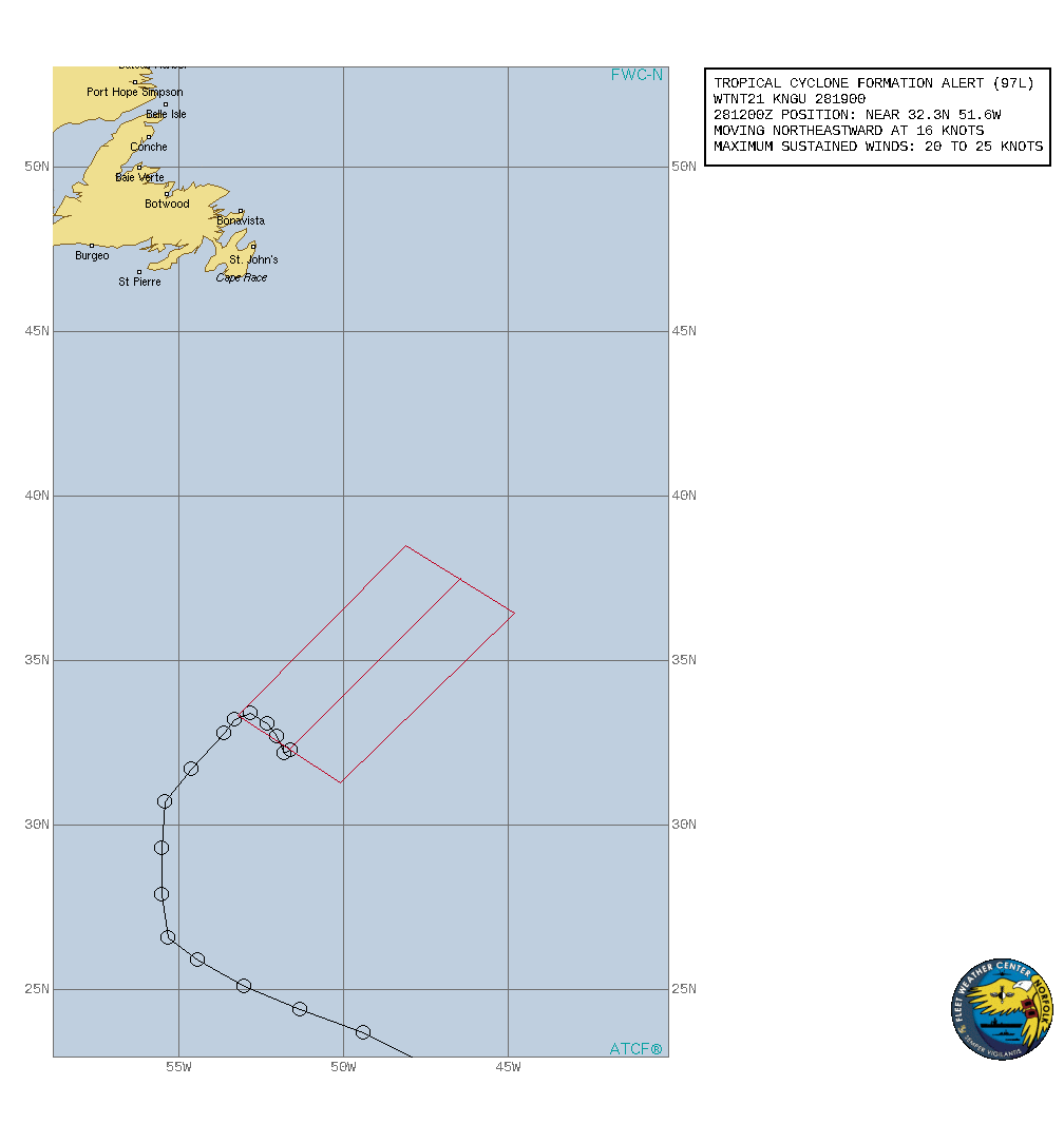
al972021.gif
回復

使用道具 舉報

12下一頁
快速回覆
您需要登錄後才可以回帖 登錄 | 立即加入

本版積分規則

本平台僅供學術討論之用,預報應以氣象局為準

威普網站虛擬主機贊助公司

臺灣第一個天氣類型社群平台 即時天氣資訊、精準颱風動態

線上客服
FB傳送訊息
廣告行銷
精準行銷 物超所值
官方粉專
發佈 快速回復 返回頂部 返回列表