開啟輔助訪問
 找回密碼
 立即加入

13S.Uriah 大起大落 巔峰短暫 年度第一個強烈熱帶氣旋

簽到天數: 3280 天

[LV.Master]伴壇終老

t02436|2016-2-14 21:45 | 顯示全部樓層
中心即將進入東經90度以西,BoM在12Z發報後,18Z將由MFR繼續接手。
IDW27600
TROPICAL CYCLONE TECHNICAL BULLETIN: AUSTRALIA - WESTERN REGION
Issued by PERTH TROPICAL CYCLONE WARNING CENTRE
at: 1257 UTC 14/02/2016
Name: Tropical Cyclone Uriah
Identifier: 09U
Data At: 1200 UTC
Latitude: 15.1S
Longitude: 90.3E
Location Accuracy: within 30 nm [55 km]
Movement Towards: southwest [232 deg]
Speed of Movement: 10 knots [19 km/h]
Maximum 10-Minute Wind: 50 knots [95 km/h]
Maximum 3-Second Wind Gust: 70 knots [130 km/h]
Central Pressure: 982 hPa
Radius of 34-knot winds NE quadrant: 90 nm [165 km]
Radius of 34-knot winds SE quadrant: 120 nm [220 km]
Radius of 34-knot winds SW quadrant: 170 nm [315 km]
Radius of 34-knot winds NW quadrant: 90 nm [165 km]
Radius of 48-knot winds NE quadrant: 40 nm [75 km]
Radius of 48-knot winds SE quadrant: 40 nm [75 km]
Radius of 48-knot winds SW quadrant: 40 nm [75 km]
Radius of 48-knot winds NW quadrant: 40 nm [75 km]
Radius of 64-knot winds:   
Radius of Maximum Winds: 30 nm [55 km]
Dvorak Intensity Code: T3.5/3.5/D0.5/24HRS STT:S0.0/06HRS
Pressure of outermost isobar: 998 hPa
Radius of outermost closed isobar: 90 nm [165 km]
FORECAST DATA
Date/Time    : Location    : Loc. Accuracy: Max Wind   : Central Pressure
[UTC]        : degrees     :      nm  [km]: knots[km/h]: hPa
+06:  14/1800: 15.7S  89.4E:     045 [085]:  060  [110]:  984
+12:  15/0000: 16.3S  88.6E:     060 [110]:  065  [120]:  981
+18:  15/0600: 16.8S  87.7E:     070 [135]:  065  [120]:  981
+24:  15/1200: 17.4S  86.9E:     085 [155]:  070  [130]:  977
+36:  16/0000: 18.0S  85.2E:     105 [195]:  075  [140]:  973
+48:  16/1200: 18.5S  83.1E:     125 [230]:  080  [150]:  969
+60:  17/0000: 19.0S  81.0E:     145 [265]:  085  [155]:  961
+72:  17/1200: 19.7S  78.8E:     160 [300]:  090  [165]:  956
+96:  18/1200: 22.3S  76.6E:     205 [380]:  090  [165]:  955
+120: 19/1200: 25.4S  76.8E:     295 [545]:  075  [140]:  966
REMARKS:
Tropical Cyclone Uriah has been moving steadily to the southwest at 10 knots
over the past 12 hours. The shear over the system has continued to decrease
allowing the LLCC to consolidate amongst curved banding.

The system centre was located using recent microwave imagery [tc_ssmis 1018UTC]
giving good confidence of the initial position. The DT is at 3.5 based on a
curved band wrap of 0.9. The trend is D which gives an MET/PAT of 3.5. This is
consistent with ADT of 3.5. The system intensity is estimated at 50 knots.

Uriah is forecast to continue in a southwesterly direction under the influence
of a sub tropical ridge to the southeast. This coupled with a low to moderate
shear environment, partially offset via good poleward outflow will lead to
gradual intensification over the next few days with the system likely to reach
hurricane intensity during Monday.

Numerical weather prediction models are in good agreement leading to a high
confidence in the forecast. Based on the current track, the system will move
into La Reunion's area of responsibility within the next 6 hours.


Copyright Commonwealth of Australia
==
The next bulletin for this system will be issued by: La Reunion RSMC.

IDW60280.png

rbtop_lalo-animated.gif
回復

使用道具 舉報

簽到天數: 588 天

[LV.9]以壇為家II

Meow|2016-2-13 21:10 | 顯示全部樓層
本帖最後由 Meow 於 2016-2-13 21:14 編輯

命名Uriah,上看四級強烈熱帶氣旋,不過到時候應該只稱「強烈熱帶氣旋」了。

IDW60280.png

  1. IDW27600
  2. TROPICAL CYCLONE TECHNICAL BULLETIN: AUSTRALIA - WESTERN REGION
  3. Issued by PERTH TROPICAL CYCLONE WARNING CENTRE
  4. at: 1300 UTC 13/02/2016
  5. Name: Tropical Cyclone Uriah
  6. Identifier: 09U
  7. Data At: 1200 UTC
  8. Latitude: 12.7S
  9. Longitude: 94.0E
  10. Location Accuracy: within 30 nm [55 km]
  11. Movement Towards: west southwest [249 deg]
  12. Speed of Movement: 8 knots [16 km/h]
  13. Maximum 10-Minute Wind: 35 knots [65 km/h]
  14. Maximum 3-Second Wind Gust: 50 knots [95 km/h]
  15. Central Pressure: 994 hPa
  16. Radius of 34-knot winds NE quadrant: 60 nm [110 km]
  17. Radius of 34-knot winds SE quadrant: 90 nm [165 km]
  18. Radius of 34-knot winds SW quadrant: 90 nm [165 km]
  19. Radius of 34-knot winds NW quadrant: 60 nm [110 km]
  20. Radius of 48-knot winds NE quadrant:   
  21. Radius of 48-knot winds SE quadrant:   
  22. Radius of 48-knot winds SW quadrant:   
  23. Radius of 48-knot winds NW quadrant:   
  24. Radius of 64-knot winds:   
  25. Radius of Maximum Winds: 40 nm [75 km]
  26. Dvorak Intensity Code: T3.0/3.0/D1.0/24HRS STT:D0.5/6HRS
  27. Pressure of outermost isobar: 1006 hPa
  28. Radius of outermost closed isobar: 180 nm [335 km]
  29. FORECAST DATA
  30. Date/Time    : Location    : Loc. Accuracy: Max Wind   : Central Pressure
  31. [UTC]        : degrees     :      nm  [km]: knots[km/h]: hPa
  32. +06:  13/1800: 13.3S  93.3E:     045 [085]:  040  [075]:  996
  33. +12:  14/0000: 13.8S  92.5E:     060 [110]:  040  [075]:  996
  34. +18:  14/0600: 14.4S  91.9E:     075 [140]:  045  [085]:  993
  35. +24:  14/1200: 15.1S  91.2E:     090 [165]:  050  [095]:  990
  36. +36:  15/0000: 16.3S  89.6E:     120 [220]:  060  [110]:  983
  37. +48:  15/1200: 17.3S  88.0E:     140 [260]:  070  [130]:  975
  38. +60:  16/0000: 17.8S  86.3E:     155 [285]:  075  [140]:  971
  39. +72:  16/1200: 18.2S  84.3E:     170 [315]:  080  [150]:  964
  40. +96:  17/1200: 19.2S  80.4E:     195 [360]:  090  [165]:  955
  41. +120: 18/1200: 21.7S  78.0E:     265 [490]:  085  [155]:  958
  42. REMARKS:
  43. The system remains under shear though the LLCC has migrated closer to the cold
  44. overcast over the last 3 to 6 hours allowing the DT to reach 3.0 and the system
  45. has been named Uriah. This is consistent with MET.

  46. Uriah has continued a general southwest track, being steered by a mid level
  47. ridge to the southeast. Model guidance is in very good agreement with a
  48. continued southwest track over the next 4 days.

  49. Intensification is likely to be slow overnight as shear prevents good
  50. organisation. As the system continues moving towards the southwest conditions do
  51. become more favourable for development with shear decreasing and the sytem is
  52. likely to reach hurricane intensity on Monday.

  53. Based on the current track, the system will move into La Reunion's area of
  54. responsibility between 1800 and 2400 UTC 14 February.  


  55. Copyright Commonwealth of Australia
  56. ==
  57. The next bulletin for this system will be issued by: 13/1900 UTC by Perth TCWC.
複製代碼
回復

使用道具 舉報

簽到天數: 3280 天

[LV.Master]伴壇終老

t02436|2016-2-12 15:26 | 顯示全部樓層
BoM 06Z編號09U,預計24小時之內命名Uriah。巔峰強度方面上望80節,能達到澳式三級強烈熱帶氣旋。
IDW27600
TROPICAL CYCLONE TECHNICAL BULLETIN: AUSTRALIA - WESTERN REGION
Issued by PERTH TROPICAL CYCLONE WARNING CENTRE
at: 0715 UTC 12/02/2016
Name: Tropical Low  
Identifier: 09U
Data At: 0600 UTC
Latitude: 10.6S
Longitude: 97.8E
Location Accuracy: within 60 nm [110 km]
Movement Towards: south southwest [211 deg]
Speed of Movement: 6 knots [11 km/h]
Maximum 10-Minute Wind: 25 knots [45 km/h]
Maximum 3-Second Wind Gust: 45 knots [85 km/h]
Central Pressure: 999 hPa
Radius of 34-knot winds NE quadrant:   
Radius of 34-knot winds SE quadrant:   
Radius of 34-knot winds SW quadrant:   
Radius of 34-knot winds NW quadrant:   
Radius of 48-knot winds NE quadrant:   
Radius of 48-knot winds SE quadrant:   
Radius of 48-knot winds SW quadrant:   
Radius of 48-knot winds NW quadrant:   
Radius of 64-knot winds:   
Radius of Maximum Winds:   
Dvorak Intensity Code: T2.0/2.0/D1.0/24HRS STT: D0.5/6HRS
Pressure of outermost isobar: 1003 hPa
Radius of outermost closed isobar: 180 nm [335 km]
FORECAST DATA
Date/Time    : Location    : Loc. Accuracy: Max Wind   : Central Pressure
[UTC]        : degrees     :      nm  [km]: knots[km/h]: hPa
+06:  12/1200: 11.1S  97.4E:     070 [130]:  030  [055]:  998
+12:  12/1800: 11.5S  96.5E:     080 [150]:  030  [055]:  998
+18:  13/0000: 11.9S  95.7E:     090 [165]:  030  [055]:  998
+24:  13/0600: 12.4S  95.0E:     100 [185]:  035  [065]:  994
+36:  13/1800: 13.6S  93.6E:     120 [220]:  045  [085]:  989
+48:  14/0600: 15.1S  92.0E:     140 [255]:  055  [100]:  983
+60:  14/1800: 16.6S  90.4E:     160 [290]:  070  [130]:  972
+72:  15/0600: 18.2S  88.6E:     175 [330]:  080  [150]:  960
+96:  16/0600: 19.9S  85.3E:     220 [410]:  080  [150]:  959
+120: 17/0600: 20.6S  80.9E:     310 [570]:  075  [140]:  964
REMARKS:
Tropical Low 09U has been slow moving to the east and has recently turned to the
SSW, as forecast by the guidance.

Microwave and scatterometer satellite data is indicated an elongated centre
which has made the centre position somewhat uncertain. Current intensity of 25
knots is based on Dvorak CI of 2.0, which is mainly based on MET and PAT.
Scatteromenter winds indicates 25 to 30 knots in areas around the system.

Now that the system has turned to the southwest, there is good agreement between
the models for a WSW track to continue. Some on of the uncertainty in the
forecast positions is based on the large initial uncertainty.

Shear diagnostics indicate strong shear of about 30 knots but with reduced shear
to the system which is where it is moving. With the shear being E'ly and the
system expected to move in a WSW direction, system relative shear should also be
reduced.

Forecast intensity is based on standard development for 72 hours [starting from
T2.0]. The intensity is then forecast to plateau due to dry air wrapping around
the system and moving towards cooler water. Weakening slowly from Feb 16 00Z
with system near 20S and colder water.


Copyright Commonwealth of Australia
==
The next bulletin for this system will be issued by: 12/1300 UTC by Perth TCWC.
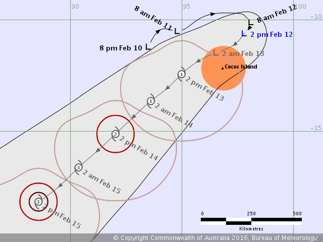
IDW60280.png
回復

使用道具 舉報

簽到天數: 3280 天

[LV.Master]伴壇終老

t02436|2016-2-12 14:30 | 顯示全部樓層
JTWC發布TCFA
sh9916.gif

vis-animated.gif
回復

使用道具 舉報

簽到天數: 3280 天

[LV.Master]伴壇終老

t02436|2016-2-11 10:47 | 顯示全部樓層
JTWC提升評級至Medium
B. TROPICAL DISTURBANCE SUMMARY:
      (1) THE AREA OF CONVECTION PREVIOUSLY LOCATED NEAR 10.6S
97.0E, IS NOW LOCATED NEAR 10.3S 95.0E, APPROXIMATELY 150 NM
NORTHWEST OF COCOS ISLAND. RECENT ANIMATED ENHANCED INFRARED
SATELLITE IMAGERY SHOWS A BAND OF DEEP CONVECTION FLARING ALONG THE
NORTHERN PERIPHERY OF A STRENGTHENING LOW LEVEL CIRCULATION CENTER
EVIDENT IN A 101821Z 89 GHZ SSMIS MICROWAVE IMAGE. UPPER-LEVEL
ANALYSIS SHOWS MODERATE (20 TO 30 KNOTS) OF VERTICAL WIND SHEAR
(VWS) BEING OFFSET BY A STRONG POLEWARD OUTFLOW CHANNEL. RECENT
SCATTEROMETRY DATA INDICATES THE PRESENCE OF 30 KNOT WINDS ON THE
WESTERN PERIPHERY.  MAXIMUM SUSTAINED SURFACE WINDS ARE ESTIMATED AT
25 TO 30 KNOTS. MINIMUM SEA LEVEL PRESSURE IS ESTIMATED TO BE NEAR
1005 MB. DUE TO THE IMPROVING STRUCTURE THE POTENTIAL FOR THE
DEVELOPMENT OF A SIGNIFICANT TROPICAL CYCLONE WITHIN THE NEXT 24
HOURS IS UPGRADED TO MEDIUM.

abiosair.jpg

20160211.0200.himawari-8.vis.99S.INVEST.30kts.1000mb.10.3S.95E.100pc.jpg
回復

使用道具 舉報

簽到天數: 3280 天

[LV.Master]伴壇終老

t02436|2016-2-10 10:40 | 顯示全部樓層
JTWC 18Z評級Low
(2) AN AREA OF CONVECTION HAS PERSISTED NEAR 11.2S 95.8E
APPROXIMATELY 85 NM NORTHWEST OF COCOS ISLAND. RECENT ANIMATED
INFRARED SATELLITE IMAGERY SHOWS PATCHY CONVECTION DEVELOPING AROUND
A WEAK LOW LEVEL CIRCULATION CENTER EVIDENT IN A 091529Z AMSU IMAGE.
THIS DISTURBANCE LIES EQUATORWARD OF AN UPPER LEVEL RIDGE AXIS, IN
AN AREA OF MODERATE NORTHERLY VERTICAL WIND SHEAR AND FAVORABLE
POLEWARD OUTFLOW ALOFT. STRONG LOW LEVEL WESTERLY FLOW TO THE NORTH
AND STRONG POLEWARD AHEAD OF AN UPPER LEVEL TROUGH APPROACHING FROM
THE SOUTHWEST ARE EXPECTED TO SUPPORT FURTHER DEVELOPMENT OF THIS
DISTURBANCE OVER THE NEXT FEW DAYS. MAXIMUM SUSTAINED SURFACE WINDS
ARE ESTIMATED AT 20 TO 25 KNOTS. MINIMUM SEA LEVEL PRESSURE IS
ESTIMATED TO BE NEAR 1006 MB. BECAUSE THE LOW LEVEL CIRCULATION IS
JUST BEGINNING TO DEVELOP AND UPPER LEVEL SUPPORT IS MARGINAL, THE
POTENTIAL FOR THE DEVELOPMENT OF A SIGNIFICANT TROPICAL CYCLONE
WITHIN THE NEXT 24 HOURS IS LOW.

abiosair.jpg

99S_gefs_latest.png

20160210.0150.himawari-8.ircolor.99S.INVEST.20kts.1005mb.10.7S.94.9E.100pc.jpg
回復

使用道具 舉報

12
快速回覆
您需要登錄後才可以回帖 登錄 | 立即加入

本版積分規則

本平台僅供學術討論之用,預報應以氣象局為準

威普網站虛擬主機贊助公司

臺灣第一個天氣類型社群平台 即時天氣資訊、精準颱風動態

線上客服
FB傳送訊息
廣告行銷
精準行銷 物超所值
官方粉專
發佈 快速回復 返回頂部 返回列表