開啟輔助訪問
 找回密碼
 立即加入

03E.Blas 風眼開啟強度上衝上C4

簽到天數: 2414 天

[LV.Master]伴壇終老

2016-7-1 02:29 | 顯示全部樓層
  四級颶風  
編號:03 E
名稱:Blas
03E.png

  基本資料  
擾動編號日期:2016 07 01 02
命名日期  :2016 07 03 17
撤編日期  :2016 07 11 22
登陸地點  :

  巔峰時期資料  
近中心最強風速 :120  kt ( CAT.4 )
海平面最低氣壓 :947 百帕

  過去路徑圖  
TWTYBBS_03E_BLAS_TRACK_t02436_TWTYBBS.jpg

  討論帖圖片  
94E.INVEST.20kts.1008mb.9N.103W

20160630.1745.goes-13.ir.94E.INVEST.20kts.1008mb.9N.103W.100pc.jpg

NHC:30%
1. A broad area of low pressure, located about 550 miles
south-southwest of Acapulco, Mexico, is producing a large but
disorganized area of showers and thunderstorms.  Environmental
conditions are forecast to be conducive for a tropical depression
to form over the weekend while the system moves westward to
west-northwestward at 10 to 15 mph, remaining well offshore of
the coast of Mexico.
* Formation chance through 48 hours...low...30 percent
* Formation chance through 5 days...high...80 percent two_pac_2d1.png

以上資料來自:NHC、颱風論壇整理製作

評分

參與人數 1水氣能量 +15 +1 收起 理由
jwpk9899 + 15 + 1

查看全部評分

回復

使用道具 舉報

簽到天數: 3279 天

[LV.Master]伴壇終老

t02436|2016-7-2 10:58 | 顯示全部樓層
NHC提升展望至Medium
2. A broad area of low pressure located about 500 miles southwest of
Acapulco, Mexico, is producing disorganized showers and
thunderstorms.  Slow development is expected tonight and on
Saturday, but environmental conditions are forecast to be conducive
for a tropical depression to form early next week while the system
moves west-northwestward at 10 to 15 mph, remaining well offshore of
the coast of Mexico.
* Formation chance through 48 hours...medium...40 percent
* Formation chance through 5 days...high...80 percent

two_pac_2d2.png

雖然發展到目前緩慢了點,但部分數值集合認為之後有望達到C3強度。
94E_intensity_latest.png

94E_gefs_latest.png

20160702.0145.goes-13.ircolor.94E.INVEST.25kts.1008mb.10.1N.105.4W.100pc.jpg

回復

使用道具 舉報

簽到天數: 3279 天

[LV.Master]伴壇終老

t02436|2016-7-3 10:43 | 顯示全部樓層
NHC升格03E,預計9小時內命名Blas,巔峰上望100節。
000
WTPZ43 KNHC 030237
TCDEP3

TROPICAL DEPRESSION THREE-E DISCUSSION NUMBER   1
NWS NATIONAL HURRICANE CENTER MIAMI FL       EP032016
900 PM MDT SAT JUL 02 2016

The deep convection associated with the area of low pressure well
southwest of Manzanillo has become much better organized during the
past 6 to 12 hours, and this system is now classified as a tropical
cyclone.  Satellite imagery shows a large convective canopy with
multiple curved bands.  The estimated center position is near the
eastern edge of the deep convection and the initial intensity is set
to 30 kt based on the latest Dvorak classification from TAFB.

The environment appears conducive for at least steady strengthening
during the next 3 days, as the cyclone will be moving over SSTs of
29-30C and in an environment of low to moderate shear and abundant
moisture.
The NHC intensity forecast shows the system becoming a
tropical storm tonight or early Sunday and becoming a hurricane on
Monday.  The system is expected to peak in intensity in 3 to 4 days
near major hurricane strength before gradual weakening begins as the
center moves over progressively cooler waters.  The official
forecast is above the intensity consensus and close to a blend of
the SHIPS, LGEM, and HWRF models.

The initial motion estimate is a somewhat uncertain 280/10 given the
recent formation of the system.  The dominant steering mechanism
through the forecast period will be the western periphery of a
subtropical ridge centered over northern Mexico and the southern
United States.  This pattern should guide the cyclone on a general
westward to west-northwestward motion during the next 5 days.  Most
of the track model guidance is in good agreement on this scenario
with the exception of the GFDL model, which is well to the right.
There is some along-track spread between the generally slower GFS
model and the faster ECMWF and HWRF through much of the period. The
across-track spread increases in 4-5 days with the GFS and GEFS
ensemble mean showing more of a poleward turn as they erode the
ridge more, while the ECMWF, ECMWF ensemble mean, and UKMET have a
stronger ridge and more westward motion. The NHC track forecast is
close to a blend of these two camps through the forecast period and
is of about average confidence.

FORECAST POSITIONS AND MAX WINDS

INIT  03/0300Z 11.1N 108.3W   30 KT  35 MPH
12H  03/1200Z 11.3N 109.6W   40 KT  45 MPH
24H  04/0000Z 11.8N 111.5W   50 KT  60 MPH
36H  04/1200Z 12.4N 113.8W   60 KT  70 MPH
48H  05/0000Z 12.9N 116.0W   75 KT  85 MPH
72H  06/0000Z 13.8N 120.5W  100 KT 115 MPH
96H  07/0000Z 15.0N 125.0W  100 KT 115 MPH
120H  08/0000Z 16.5N 129.0W   85 KT 100 MPH

$$
Forecaster Brennan

023357W_NL_sm.gif

rbtop-animated.gif
回復

使用道具 舉報

簽到天數: 3279 天

[LV.Master]伴壇終老

t02436|2016-7-3 18:37 | 顯示全部樓層
09Z命名Blas,持續上望MH。
000
WTPZ43 KNHC 030858
TCDEP3

TROPICAL STORM BLAS DISCUSSION NUMBER   2
NWS NATIONAL HURRICANE CENTER MIAMI FL       EP032016
300 AM MDT SUN JUL 03 2016

Conventional and microwave satellite imagery indicate that a long
curved band of convection now wraps at least half way around the
low-level center. Dvorak satellite intensity estimates have
increased as result, with TAFB coming in at T2.5/35 kt and SAB at
T3.0/45 kt. Therefore, the depression has been upgraded to Tropical
Storm Blas.

The initial motion estimate is 285/12, based heavily on microwave
fix positions. Overall, there is no significant change to the
previous forecast track or reasoning. Blas is expected to move
along the southwestern periphery of a deep-layer subtropical ridge
located over northern Mexico and the southern United States.  This
stable steering pattern should keep Blas moving in a general
westward to west-northwestward direction for the next 120 hours.
The NHC track forecast is slightly north of the previous forecast
track, and closely follows the consensus track model TVCE.

Environmental conditions appear favorable for steady strengthening
during the next 72 hours as Blas moves over SSTs of 29-30C and
encounters decreasing vertical wind shear of less than 10 kt. The
new NHC intensity forecast shows Blas becoming a hurricane on Monday
and a major hurricane by Wednesday. Gradual weakening is expected to
begin by 96 hours or so as the cyclone starts to move over 26C or
cooler seas-surface temperatures, which should result in some cold
upwelling or mixing beneath Blas. The official forecast is above the
intensity consensus IVCN, and close to the previous intensity
forecast and a blend of the SHIPS and LGEM models.

FORECAST POSITIONS AND MAX WINDS

INIT  03/0900Z 11.7N 109.7W   35 KT  40 MPH
12H  03/1800Z 12.0N 111.0W   45 KT  50 MPH
24H  04/0600Z 12.6N 113.1W   55 KT  65 MPH
36H  04/1800Z 13.1N 115.3W   65 KT  75 MPH
48H  05/0600Z 13.6N 117.5W   80 KT  90 MPH
72H  06/0600Z 14.6N 122.1W  100 KT 115 MPH
96H  07/0600Z 15.8N 126.4W   95 KT 110 MPH
120H  08/0600Z 17.3N 130.1W   80 KT  90 MPH

$$
Forecaster Stewart

084430W_NL_sm.gif

rb-animated.gif
回復

使用道具 舉報

簽到天數: 241 天

[LV.8]以壇為家I

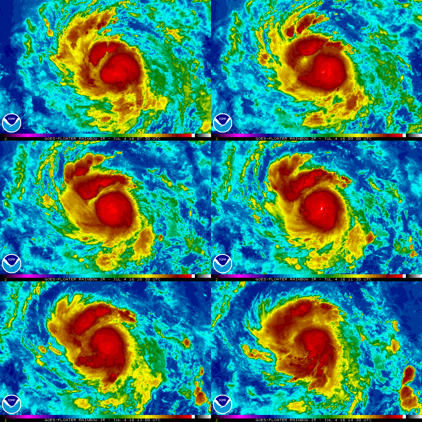
krichard2011|2016-7-4 18:36 | 顯示全部樓層
目前現在的型態相當良好
也有逐漸整合底層的趨勢
所處的環境也大致符合發展條件
模式方面也看好後期發展 但隨著這系統西移
水氣將逐漸遞減 不利於這系統發展而有逐漸減弱的趨勢
20160704.1001.goes-15.ircolor.03E.BLAS.55kts.1001mb.12.5N.112.5W.100pc.jpg
20160704.0507.metopa.89rgb.03E.BLAS.55kts.1001mb.12.2N.111.7W.85pc.jpg
2016EP03_16KMGWVP_201607040900.GIF
wg9sht.GIF
2016EP03_OHCNFCST_201607040600.GIF
03E_intensity_latest.png
回復

使用道具 舉報

簽到天數: 3279 天

[LV.Master]伴壇終老

t02436|2016-7-4 23:25 | 顯示全部樓層
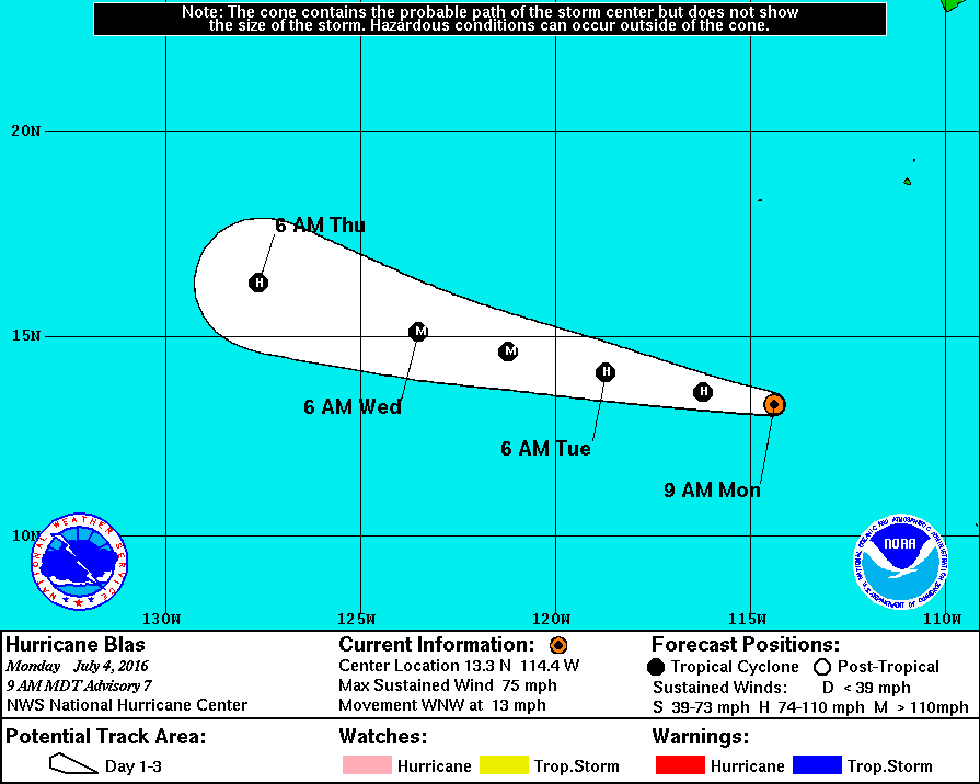
12Z速報評價65節,15Z正報維持評價,C1達成。
000
WTPZ43 KNHC 041443
TCDEP3

HURRICANE BLAS DISCUSSION NUMBER   7
NWS NATIONAL HURRICANE CENTER MIAMI FL       EP032016
900 AM MDT MON JUL 04 2016

Blas' cloud pattern consists of a large mass of cold-topped central
convection and a couple of fragmented outer bands.  A 1027 UTC SSM/I
pass revealed a ragged mid-level eye feature, but the low-level
structure appeared less organized.  Dvorak satellite classifications
were T4.0/65 kt and T4.5/77 kt from SAB and TAFB, respectively.
Taking into account the overnight ASCAT pass, the initial intensity
is set at 65 kt, the low end of the intensity estimates.

The initial motion estimate is unchanged at 285/11.  The track
forecast remains straightforward. Blas is expected to be steered
along the southern side of a deep-layer subtropical ridge extending
westward from northern Mexico and the southern United States during
the next 3-4 days.  The cyclone should reach the western periphery
of the ridge by days 4-5, which should result in a turn nearly
toward the northwest.  The model guidance is in relatively good
agreement throughout the forecast period, though the GFS and ECMWF
models diverge some after day 3.  The NHC track forecast does not
deviate much from the previous one and is north of the southernmost
ECMWF owing to the forecast of a strong hurricane, more like the GFS
solution indicates.

The large-scale environment surrounding Blas is characterized by
light to moderate northeasterly shear and a rich supply of
moisture.  Coupled with warm-enough waters, Blas should intensify
into a large and intense hurricane during the next couple of days
once it establishes a better organized inner core. The NHC intensity
forecast continues to lean heavily on the statistical guidance, some
of which strengthens Blas even more than the current forecast.
Around 72 hours, even though the shear should still be low, the
hurricane should enter a drier and more stable environment and begin
traversing sub-26 deg C waters.  This should promote a slow
weakening trend that will accelerate after 96 hours once Blas moves
over much cooler waters.


FORECAST POSITIONS AND MAX WINDS

INIT  04/1500Z 13.3N 114.4W   65 KT  75 MPH
12H  05/0000Z 13.6N 116.2W   75 KT  85 MPH
24H  05/1200Z 14.1N 118.7W   90 KT 105 MPH
36H  06/0000Z 14.6N 121.2W  105 KT 120 MPH
48H  06/1200Z 15.1N 123.5W  110 KT 125 MPH
72H  07/1200Z 16.3N 127.6W   95 KT 110 MPH
96H  08/1200Z 17.8N 131.3W   75 KT  85 MPH
120H  09/1200Z 19.8N 134.7W   50 KT  60 MPH

$$
Forecaster Kimberlain
144237W_NL_sm.gif

rb-animated.gif
回復

使用道具 舉報

簽到天數: 3279 天

[LV.Master]伴壇終老

t02436|2016-7-6 12:11 | 顯示全部樓層
來關心一下隔壁棚也很努力的Blas好了
風眼經過不少時間的調整,終於趨近渾圓了@@
NHC 03Z評價120節,正式成為四級颶風。
000
WTPZ43 KNHC 060233
TCDEP3

HURRICANE BLAS DISCUSSION NUMBER  13
NWS NATIONAL HURRICANE CENTER MIAMI FL       EP032016
800 PM PDT TUE JUL 05 2016

Blas continues to intensify.  Satellite images indicate that Blas
has a typical appearance of a major hurricane with a distinct eye
surrounded by a fairly symmetric ring of deep convection.  The
Dvorak CI-numbers at 0000 UTC were 6.0/115 kt from TAFB and SAB, and
recent ADT values from CIMSS at the University of Wisconsin are a
little higher.  Based on these estimates and the continued
improvement in organization since the time of the classifications,
the initial wind speed is set at 120 kt.  This makes Blas a category
4 hurricane on the Saffir-Simpson Hurricane Wind Scale.

The hurricane has slowed a little in forward speed, and the
latest initial motion estimate is 275/11 kt.  The models are in
very good agreement for the next 3 days or so in showing Blas
continuing westward to west-northwestward on the southwest side of a
mid-level ridge centered over Mexico and the eastern Pacific Ocean.
After that time, however, the model solutions diverge with the bulk
of the guidance showing a northwestward motion due to the cyclone
interacting with a cut-off low northeast of the Hawaiian Islands.
The ECMWF model has a notably different solution showing little
involvement with the cut-off low, which results in Blas continuing
westward. No significant changes were made to the previous
prediction and this track forecast lies close to a consensus of the
GFS and ECMWF models. It should be noted that there is low
confidence at the latter forecast points.

Blas still has another 12-18 hours of favorable conditions for
strengthening.  Beyond that time, the cyclone is expected to move
over cool water and into a progressively drier air mass.
  These
conditions should end the strengthening phase and cause a steady
weakening trend.  The official NHC intensity forecast lies at the
upper end the guidance in the short term, but then falls in line
with the intensity model consensus from 36-120 h.

FORECAST POSITIONS AND MAX WINDS

INIT  06/0300Z 14.4N 121.7W  120 KT 140 MPH
12H  06/1200Z 14.8N 123.4W  130 KT 150 MPH
24H  07/0000Z 15.4N 125.5W  120 KT 140 MPH
36H  07/1200Z 16.0N 127.4W  100 KT 115 MPH
48H  08/0000Z 16.6N 129.0W   85 KT 100 MPH
72H  09/0000Z 18.2N 132.1W   65 KT  75 MPH
96H  10/0000Z 20.2N 135.7W   45 KT  50 MPH
120H  11/0000Z 21.6N 139.8W   30 KT  35 MPH...POST-TROP/REMNT LOW

$$
Forecaster Cangialosi

023423W_NL_sm.gif

20160706.0311.f18.91pct91h91v.03E.BLAS.115kts.952mb.14.3N.121.2W.50pc.jpg

報文中提及系統還有約半天到一天的時間可以增強,之後將受到乾空氣與海溫影響而逐漸減弱,能否進入中太還是未知數。
2016EP03_16KMGWVP_201607060300.GIF

cdas-sflux_sst_epac_1.png

rb-animated.gif

rbtop-animated.gif

點評

他距離夏威夷群島還有 25 個經度,大概到達之前就被乾空氣吃掉了。  發表於 2016-7-6 16:12
以它目前的移動方向看來,過幾天可能有機會會影響到夏威夷群島。  發表於 2016-7-6 14:39
回復

使用道具 舉報

快速回覆
您需要登錄後才可以回帖 登錄 | 立即加入

本版積分規則

本平台僅供學術討論之用,預報應以氣象局為準

威普網站虛擬主機贊助公司

臺灣第一個天氣類型社群平台 即時天氣資訊、精準颱風動態

線上客服
FB傳送訊息
廣告行銷
精準行銷 物超所值
官方粉專
發佈 快速回復 返回頂部 返回列表