開啟輔助訪問
 找回密碼
 立即加入

01C.Walaka 中太時隔32個月迎土產氣旋 猛烈爆發成為C5

簽到天數: 1826 天

[LV.Master]伴壇終老

typhoonman|2018-10-2 09:29 來自手機 | 顯示全部樓層
RAMMB給出140KTS,成為2006年IOKE後在中太土生土長的CAT 5,(LANE是東太跨界後在中太增強成CAT 5,所以不算)。
20181002_092209.jpg
回復

使用道具 舉報

簽到天數: 582 天

[LV.9]以壇為家II

蜜露|2018-10-2 10:01 | 顯示全部樓層


這個有實測的話 , 肯定比雷恩強


2018CP01_4KMSRBDC_201810020030.jpg


可能強度不輸伊歐佳, 或者瓦拉卡比伊歐佳稍強


路徑也有點像伊尼基.. 後期北上..


回復

使用道具 舉報

簽到天數: 601 天

[LV.9]以壇為家II

霧峰追風者|2018-10-2 10:58 | 顯示全部樓層
CPHC 稍早強度升五級颶風,逐漸轉向北上。
WTPA41 PHFO 020248
TCDCP1

Hurricane Walaka Discussion Number  10
NWS Central Pacific Hurricane Center Honolulu HI   CP012018
500 PM HST Mon Oct 01 2018

Recent infrared images showed that cloud tops surrounding the eye
have warmed somewhat since early this morning, but still form a
solid ring with temperatures in the -70 to -76C range. Dvorak
intensity estimates came in at 6.5/127kt from PHFO and SAB. UW/CIMSS
ADT data indicated 7.0/140kt at 0000 UTC. The current intensity for
this advisory is 140 kt as a nod to the ADT value, since the
subjective Dvorak estimates have been constrained by fix rules. Of
additional interest, microwave data from the NOAA-18 1949 UTC and
METOP-B at 2108 UTC showed the development of an outer eyewall,
which indicates Hurricane Walaka is going through an eyewall
replacement cycle. An ASCAT pass from 2107 UTC caught the eastern
semicircle of Walaka's circulation, which resulted in the expansion
of the 34 kt radii in the northeast quadrant.

The initial motion of Walaka is 310/6 kt as it rounds the
southwestern flank of a subtropical ridge. A deepening low pressure
system north of Walaka is in the process of altering the steering
current, causing the hurricane to turn toward the north. The
numerical models are in good agreement with the scenario and the
track guidance is tightly packed, especially through 48 hours.
Walaka is expected to accelerate northward under the
influence of the low Wednesday into Thursday. The forecast
track for this advisory is close to the previous forecast and the
HCCA consensus, especially through 36 hours.

With sea surface temperatures under Walaka expected to remain near
30C through tonight, high ocean heat content, and low vertical wind
shear, there is still a window for additional strengthening tonight.
However, eyewall replacement cycles will result in intensity
fluctuations, which are difficult to forecast. SHIPS guidance
indicates strengthening to 153 kt while the dynamical models show
peak intensities below 145 kt. The forecast maintains slight
intensification tonight, followed by a gradual weakening through 48
hours. This is consistent with HCCA. Beyond 48 hours, increasing
vertical wind shear, followed by a track over sub-26.5C waters will
result in more rapid weakening through 120 hours. The forecast
drops Walaka below hurricane strength after 96 hours, which is
a less aggressive weakening than all objective aids.

The forecast track will take Walaka near Johnston Island on Tuesday,
so the Hurricane Warning remains in effect for this location. The
forecast track also takes the hurricane across the Papahanaumokuakea
Marine National Monument between French Frigate Shoals and Laysan
Island late Wednesday. Thus, a Hurricane Watch has been issued for
the region from Nihoa to Maro Reef.


FORECAST POSITIONS AND MAX WINDS

INIT  02/0300Z 13.2N 169.8W  140 KT 160 MPH
12H  02/1200Z 14.4N 170.5W  145 KT 165 MPH
24H  03/0000Z 16.3N 170.6W  140 KT 160 MPH
36H  03/1200Z 18.9N 170.0W  135 KT 155 MPH
48H  04/0000Z 22.2N 168.7W  125 KT 145 MPH
72H  05/0000Z 28.4N 167.7W   90 KT 105 MPH
96H  06/0000Z 31.5N 166.4W   65 KT  75 MPH
120H  07/0000Z 37.0N 161.0W   50 KT  60 MPH

$$
Forecaster Kodama
CP012018_5day_cone_no_line_10.png 20181002.0230.goes-15.ir.01C.WALAKA.140kts.920mb.12.9N.169.6W.100pc.jpg 20181002.0142.f15.vis.olsviscomp.01C.WALAKA.x.jpg 20181002.0142.f15.ir.olsircomp.01C.WALAKA.x.jpg bd-animated (5).gif rbtop-animated (17).gif

回復

使用道具 舉報

簽到天數: 3279 天

[LV.Master]伴壇終老

t02436|2018-10-3 01:22 | 顯示全部樓層
開始轉北進行,15Z略微減弱到135節。
WTPA41 PHFO 021518
TCDCP1

Hurricane Walaka Discussion Number  12
NWS Central Pacific Hurricane Center Honolulu HI   CP012018
500 AM HST Tue Oct 02 2018

The satellite presentation of Walaka which was being degraded by an
eye wall replacement cycle overnight, has just begun to improve with
a ring of deep convection beginning to once again encircle the
well defined eye, which could be a sign that the eyewall replacement
cycle is getting ready to complete. The latest intensity estimates
from PHFO, SAB, JTWC were 6.5 (127 knots) while the ADT held at 6.6
(130 knots). Based on constraints likely holding the intensity of
Walaka too low Monday afternoon, have only reduced the initial
intensity slightly with this advisory to 135 knots. The initial
motion was set at 350/09 knots.

A deep north Pacific upper level low in the vicinity of 30N 170W
will draw Walaka northward over the next several days, before
another sharp upper trough shifting across the north Pacific picks
the tropical cyclone up and shifts it off to the northeast Friday
night and Saturday. Overall the guidance envelope remains fairly
tightly clustered through the forecast period. The official forecast
remains very close to that of the previous advisory and is fairly
well aligned with the latest GFEX, TVCN, HCCA consensus guidance.

The environment surrounding Walaka remains conducive for additional
intensification during the next 24 hours. The tropical cyclone will
remain within a deep moist airmass with low vertical wind shear,
high ocean heat content and sea surface temperatures between 84 to
86 Fahrenheit. Eyewall replacement cycles could lead to some
fluctuations in intensity through this time frame, so the intensity
forecast shows little intensity change through 24 hours. Beyond 24
hours, the combination of increasing vertical wind shear, drier
mid-level air entraining into the cyclone, sea surface temperatures
becoming marginal and even unfavorable, along with interaction with
the deep upper level low should result in steady and even rapid
weakening of Walaka. As a result, the intensity forecast calls for
Walaka to begin weakening on Wednesday, with rapid weakening then
continuing through the end of the forecast period. The official
intensity forecast was adjusted downward slightly, but remains above
all guidance through 36 hours before trending closer to a blend of
the statistical and dynamical models thereafter. Walaka is expected
to become an post-tropical/extra-tropical low by 120 hours.

The forecast track will take Walaka near Johnston Island later
today, with hurricane conditions expected this afternoon and this
evening. Therefore a Hurricane Warning remains in effect for this
location. The forecast track also takes the hurricane across the
Papahanaumokuakea Marine National Monument between French Frigate
Shoals and Laysan Island late Wednesday. Therefore, a Hurricane
Watch remains in effect for the region from Nihoa to Maro Reef.


FORECAST POSITIONS AND MAX WINDS

INIT  02/1500Z 14.7N 170.0W  135 KT 155 MPH
12H  03/0000Z 16.2N 170.2W  135 KT 155 MPH
24H  03/1200Z 18.9N 169.7W  135 KT 155 MPH
36H  04/0000Z 22.3N 168.4W  120 KT 140 MPH
48H  04/1200Z 26.2N 167.4W  100 KT 115 MPH
72H  05/1200Z 30.5N 168.0W   75 KT  85 MPH
96H  06/1200Z 33.0N 164.0W   60 KT  70 MPH
120H  07/1200Z 41.0N 157.5W   50 KT  60 MPH...POST-TROP/EXTRATROP

$$
Forecaster Jelsema
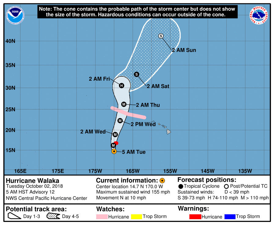
CP012018_5day_cone_no_line_12.png

rbtop-animated.gif

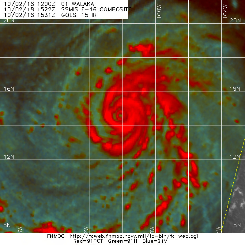
20181002.1522.f16.91pct91h91v.01C.WALAKA.135kts.927mb.14.2N.170W.100pc.jpg
回復

使用道具 舉報

簽到天數: 582 天

[LV.9]以壇為家II

蜜露|2018-10-5 22:28 | 顯示全部樓層
本帖最後由 蜜露 於 2018-10-6 12:39 編輯


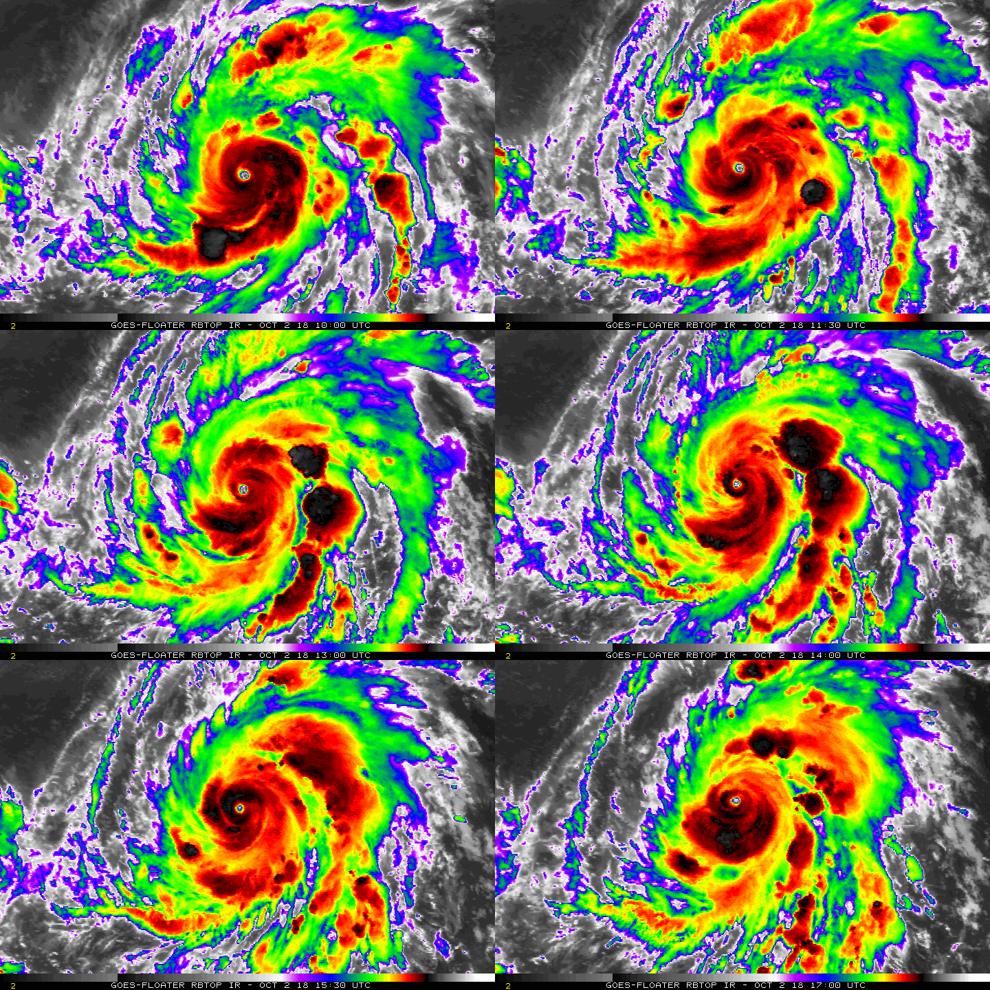
瓦拉卡颶風巔峰照


20181001.1900.goes-15.ir.01C.WALAKA.125kts.935mb.12.6N.168.9W.100pc.jpg


20181001.1830.goes-15.ircolor.01C.WALAKA.125kts.935mb.12.6N.168.9W.100pc.jpg


20181002.0031.goes-15.ir.01C.WALAKA.140kts.920mb.12.9N.169.6W.100pc.jpg


20181002.0131.goes-15.ircolor.01C.WALAKA.140kts.920mb.12.9N.169.6W.100pc.jpg


20181002.0131.goes15.x.wv1km.01CWALAKA.140kts-920mb-129N-1696W.91pc.jpg


回復

使用道具 舉報

12
快速回覆
您需要登錄後才可以回帖 登錄 | 立即加入

本版積分規則

本平台僅供學術討論之用,預報應以氣象局為準

威普網站虛擬主機贊助公司

臺灣第一個天氣類型社群平台 即時天氣資訊、精準颱風動態

線上客服
FB傳送訊息
廣告行銷
精準行銷 物超所值
官方粉專
發佈 快速回復 返回頂部 返回列表