開啟輔助訪問
 找回密碼
 立即加入

16L.Nana 牙買加近岸實測命名 貝里斯近岸升格C1後登陸

簽到天數: 1650 天

[LV.Master]伴壇終老

2020-8-30 20:24 來自手機 | 顯示全部樓層
  基本資料  
編號    :16 L
擾動編號日期:2020 08 30 20
撤編日期  :2020 09 04 23

99L INVEST 200830 1200 20.0N 40.0W ATL 15 NA
20200830.1150.goes-16.ir.99L.INVEST.15kts.1008mb.20N.40W.100pc.jpg

NHC稍後重新定強定位:99L INVEST 200830 1200 12.0N 62.5W ATL 25 1008
20200830.1220.goes-16.ir.99L.INVEST.25kts.1008mb.12N.62.5W.100pc.jpg

  NHC:20%
1. Showers and thunderstorms associated with a tropical wave are
gradually moving westward away from the Lesser Antilles. Although
the disturbance remains disorganized at this time, some gradual
development of this system is possible during the next several days
while it moves westward at 15 to 20 mph across the Caribbean Sea.
Regardless of development, this system will continue to produce
gusty winds and locally heavy rainfall across portions of the
Windward and Leeward Islands this morning before diminishing this
afternoon.
* Formation chance through 48 hours...low...20 percent.
* Formation chance through 5 days...low...30 percent.

two_atl_2d1.png two_atl_5d1.png

巔峰強度:65KT

評分

參與人數 1水氣能量 +15 +1 收起 理由
king111807 + 15 + 1 熱帶擾動首帖

查看全部評分

回復

使用道具 舉報

簽到天數: 1650 天

[LV.Master]伴壇終老

老農民版夜神月|2020-8-31 02:56 | 顯示全部樓層
本帖最後由 老農民版夜神月 於 2020-8-31 04:22 編輯

NHC展望一舉提升至70%/80%;FWC-N亦於30/1900Z發布TCFA
WTNT21 KNGU 301900
SUBJ/TROPICAL CYCLONE FORMATION ALERT//
RMKS/1. FORMATION OF A SIGNIFICANT TROPICAL CYCLONE IS POSSIBLE
WITHIN 100 NM EITHER SIDE OF A LINE FROM 12.7N 63.9W
TO 12.7N 70.2W WITHIN THE NEXT 24 HOURS. AVAILABLE DATA DOES
NOT JUSTIFY ISSUANCE OF NUMBERED TROPICAL CYCLONE WARNINGS AT
THIS TIME. WINDS IN THE AREA ARE ESTIMATED TO BE 20 TO 25 KNOTS.
2. A CONVECTIVELY ACTIVE TROPICAL WAVE AND
ASSOCIATED LOW PRESSURE AREA IS LOCATED OVER THE EASTERN
CARIBBEAN SEA. SHOWERS AND THUNDERSTORMS PRODUCED BY THE WAVE ARE
GRADUALLY BECOMING BETTER ORGANIZED. ENVIRONMENTAL CONDITIONS ARE
FORECAST TO BECOME MORE FAVORABLE FOR FURTHER DEVELOPMENT AND A
TROPICAL DEPRESSION IS LIKELY TO FORM DURING THE NEXT 24 HOURS AS
THE SYSTEM MOVES WESTWARD AT 15 TO 20 KT ACROSS THE CENTRAL
CARIBBEAN SEA.
3. THIS ALERT WILL BE REISSUED, UPGRADED TO
WARNING, OR CANCELLED BY 311900Z.//
al992020.20200830194257.gif

1. A westward-moving tropical wave accompanied by a broad low pressure
area is located over the eastern Caribbean Sea just west of the
Windward Islands. Associated shower and thunderstorm activity
continues to show signs of organization, and environmental
conditions are expected to gradually become more conducive for
development. A tropical depression is likely to form during the
next day or two while the system moves moves westward at about 15
mph across the central Caribbean Sea.  Interests in Jamaica,
Honduras, Belize, Guatemala and Yucatan should monitor the progress
of this disturbance.
* Formation chance through 48 hours...high...70 percent.
* Formation chance through 5 days...high...80 percent.

two_atl_2d1.png two_atl_5d1.png
LATEST.jpg 20200830.1103.f17.91pct91h91v.99L.INVEST.25kts.1008mb.12N.62.5W.090pc.jpg

評分

參與人數 1水氣能量 +15 收起 理由
king111807 + 15 TCFA

查看全部評分

回復

使用道具 舉報

簽到天數: 1650 天

[LV.Master]伴壇終老

老農民版夜神月|2020-9-1 23:08 | 顯示全部樓層
本帖最後由 老農民版夜神月 於 2020-9-2 00:15 編輯

NHC15Z升格PTC(潛在熱帶氣旋)16L,上望50KT
000
WTNT41 KNHC 011500
TCDAT1

Potential Tropical Cyclone Sixteen Discussion Number   1
NWS National Hurricane Center Miami FL       AL162020
1100 AM EDT Tue Sep 01 2020

An Air Force Reserve reconnaissance aircraft is currently
investigating the vigorous tropical disturbance located south of
Jamaica that the NHC has been tracking the past few days across the
Caribbean Sea. An earlier report of 35 kt winds this morning from
ship MAOR4 is the basis for the 35-kt initial intensity on
Potential Tropical Cyclone Sixteen. (PTC-16)

The initial motion estimate is an uncertain 285/16 kt, based mainly
on past scatterometer surface wind data and passive microwave
satellite fix data. A strong deep-layer to the north of the system
is expected to build slowly westward over the next few days,
keeping the disturbance moving in a general west-northwestward to
westward direction through 48 hours, followed by a turn toward the
west-southwest shortly thereafter when the system will be inland
over Central America. The NHC official forecast track lies close
to a blend of the simple consensus models TVCN and GFEX, and the
corrected-consensus model HCCA.

The disturbance has already developed an upper-level anticyclone,
with outflow only restricted in the northeastern quadrant due to
northeasterly shear of about 15 kt. This modest northeasterly to
easterly vertical wind shear is expected to gradually subside to
less than 10 kt by 48 hours, which should allow for at least some
slow but steady strengthening, given that sea-surface temperatures
(SST) will be 29.5-30.5 deg C along the track. Occasional intrusions
of dry mid-level air might hinder development for the next 24-36
hours, but model guidance shows that the atmosphere is expected to
moisten thereafter and right up until landfall. The official
intensity forecast is similar to the consensus of the intensity
guidance through 24 hours, and then is a little above the consensus
at 36 h and 48 h due to the very warm waters, moistening atmosphere,
and low shear conditions. The statistical SHIPS guidance suggests
that the cyclone could reach hurricane strength just prior to
landfall. This alternate scenario will be evaluated on the next
advisory cycle.

Due to the system's expected proximity to the north coast of
Honduras and Roatan Island, a Tropical Storm Watch has been
issued for those areas. Additional watches and possible warnings
will likely be required later today for Guatemala, Belize, and the
southern portion of the Yucatan Peninsula.


FORECAST POSITIONS AND MAX WINDS

INIT  01/1500Z 16.1N  77.5W   35 KT  40 MPH...POTENTIAL TROP CYCLONE
12H  02/0000Z 16.4N  79.6W   35 KT  40 MPH...TROPICAL STORM
24H  02/1200Z 16.6N  82.3W   40 KT  45 MPH
36H  03/0000Z 16.7N  85.1W   45 KT  50 MPH
48H  03/1200Z 16.8N  87.4W   50 KT  60 MPH
60H  04/0000Z 16.5N  89.6W   25 KT  30 MPH...INLAND
72H  04/1200Z 15.7N  91.7W   15 KT  15 MPH...POST-TROP/REMNT LOW
96H  05/1200Z...DISSIPATED

$$
Forecaster Stewart
0_5day_cone_with_line_and_wind.png
20200901.1420.goes-16.vis.2km.16L.SIXTEEN.35kts.1005mb.16N.76.8W.pc.jpg GOES14402020245ENn7F9.jpg
20200901.1217.f17.composite.99L.INVEST.30kts.1008mb.15.1N.75.5W.060pc.jpg
回復

使用道具 舉報

簽到天數: 3279 天

[LV.Master]伴壇終老

t02436|2020-9-2 00:17 | 顯示全部樓層
NHC根據最新穿心實測結果,於16Z緊急命名Nana。
000
WTNT61 KNHC 011610
TCUAT1

Tropical Storm Nana Tropical Cyclone Update
NWS National Hurricane Center Miami FL       AL162020
1205 PM EDT Tue Sep 01 2020

...POTENTIAL TROPICAL CYCLONE STRENGTHENS TO TROPICAL STORM NANA...

Air Force Reserve Hurricane Hunter aircraft data indicate that the
potential tropical cyclone has become Tropical Storm Nana. The
maximum winds are estimated to be 50 mph (85 km/h) with higher
gusts.
  A special advisory will be issued to update the forecast
within the hour.

SUMMARY OF 1205 PM AST...1605 UTC...INFORMATION
----------------------------------------------
LOCATION...16.5N 77.7W
ABOUT 120 MI...195 KM SW OF KINGSTON JAMAICA
MAXIMUM SUSTAINED WINDS...50 MPH...85 KM/H
PRESENT MOVEMENT...W OR 280 DEGREES AT 18 MPH...30 KM/H
MINIMUM CENTRAL PRESSURE...1004 MB...29.65 INCHES
$$
Forecaster Blake/Stewart

recon_AF307-01FFA-INVEST_timeseries.png

recon_AF307-01FFA-INVEST.png
305
URNT12 KNHC 011615
VORTEX DATA MESSAGE   AL992020
A. 01/15:36:50Z
B. 16.48 deg N 077.60 deg W
C. 925 mb 720 m
D. EXTRAP 1004 mb
E. NA
F. OPEN NE
G. C6
H. 45 kt
I. 335 deg 4 nm 15:35:30Z
J. 064 deg 53 kt
K. 335 deg 4 nm 15:35:30Z
L. 53 kt
M. 074 deg 8 nm 15:40:00Z
N. 171 deg 60 kt
O. 078 deg 7 nm 15:39:30Z
P. 19 C / 762 m
Q. 23 C / 759 m
R. 19 C / NA
S. 12345 / 9
T. 0.02 / 1.25 nm
U. AF307 01FFA INVEST OB 12
MAX FL WIND 60 KT 078 / 7 NM 15:39:30Z
SLP EXTRAP FROM 925 MB
;

GOES16162020245Djb9vI.jpg

17Z命名報
000
WTNT21 KNHC 011647
TCMAT1

TROPICAL STORM NANA SPECIAL FORECAST/ADVISORY NUMBER   2
NWS NATIONAL HURRICANE CENTER MIAMI FL       AL162020
1700 UTC TUE SEP 01 2020

CHANGES IN WATCHES AND WARNINGS WITH THIS ADVISORY...

THE GOVERNMENT OF BELIZE HAS ISSUED A TROPICAL STORM WATCH FOR THE
ENTIRE COAST OF BELIZE FROM NORTH OF PUNTA BARRIOS GUATEMALA
NORTHWARD TO SOUTH OF CHETUMAL MEXICO.

SUMMARY OF WATCHES AND WARNINGS IN EFFECT...

A TROPICAL STORM WATCH IS IN EFFECT FOR...
* NORTHERN HONDURAS
* ROATAN ISLAND AND THE BAY ISLANDS OF HONDURAS
* BELIZE

A TROPICAL STORM WATCH MAY BE REQUIRED FOR PORTIONS OF GUATEMALA
AND THE SOUTHERN YUCATAN PENINSULA LATER TODAY.

A TROPICAL STORM WATCH MEANS THAT TROPICAL STORM CONDITIONS ARE
POSSIBLE WITHIN THE WATCH AREA...GENERALLY WITHIN 48 HOURS.

TROPICAL STORM CENTER LOCATED NEAR 16.6N  77.9W AT 01/1700Z
POSITION ACCURATE WITHIN  20 NM

PRESENT MOVEMENT TOWARD THE WEST OR 280 DEGREES AT  14 KT

ESTIMATED MINIMUM CENTRAL PRESSURE 1004 MB
MAX SUSTAINED WINDS  45 KT WITH GUSTS TO  55 KT.
34 KT....... 70NE   0SE   0SW  70NW.
12 FT SEAS.. 70NE   0SE   0SW  70NW.
WINDS AND SEAS VARY GREATLY IN EACH QUADRANT.  RADII IN NAUTICAL
MILES ARE THE LARGEST RADII EXPECTED ANYWHERE IN THAT QUADRANT.

REPEAT...CENTER LOCATED NEAR 16.6N  77.9W AT 01/1700Z
AT 01/1200Z CENTER WAS LOCATED NEAR 16.3N  76.8W

FORECAST VALID 02/0000Z 16.6N  79.5W
MAX WIND  50 KT...GUSTS  60 KT.
50 KT... 20NE   0SE   0SW   0NW.
34 KT... 70NE   0SE   0SW  70NW.

FORECAST VALID 02/1200Z 16.7N  82.3W
MAX WIND  55 KT...GUSTS  65 KT.
50 KT... 30NE  20SE   0SW  20NW.
34 KT... 70NE  40SE   0SW  70NW.

FORECAST VALID 03/0000Z 16.8N  85.1W
MAX WIND  60 KT...GUSTS  75 KT.
50 KT... 30NE  20SE   0SW  20NW.
34 KT... 70NE  40SE   0SW  70NW.

FORECAST VALID 03/1200Z 16.8N  87.4W
MAX WIND  65 KT...GUSTS  80 KT.
64 KT... 15NE   0SE   0SW  15NW.
50 KT... 30NE  20SE   0SW  30NW.
34 KT... 70NE  50SE  30SW  70NW.

FORECAST VALID 04/0000Z 16.5N  89.6W...INLAND
MAX WIND  30 KT...GUSTS  40 KT.

FORECAST VALID 04/1200Z 15.7N  91.7W...POST-TROP/REMNT LOW
MAX WIND  15 KT...GUSTS  20 KT.

EXTENDED OUTLOOK. NOTE...ERRORS FOR TRACK HAVE AVERAGED NEAR 150 NM
ON DAY 4 AND 175 NM ON DAY 5...AND FOR INTENSITY NEAR 15 KT EACH DAY

OUTLOOK VALID 05/1200Z...DISSIPATED

REQUEST FOR 3 HOURLY SHIP REPORTS WITHIN 300 MILES OF 16.6N  77.9W

INTERMEDIATE PUBLIC ADVISORY...WTNT31 KNHC/MIATCPAT1...AT 01/1800Z

NEXT ADVISORY AT 01/2100Z

$$
FORECASTER STEWART
回復

使用道具 舉報

簽到天數: 1650 天

[LV.Master]伴壇終老

老農民版夜神月|2020-9-2 03:40 | 顯示全部樓層
本帖最後由 老農民版夜神月 於 2020-9-2 03:42 編輯

NHC於新報將Nana上望上調至C1下限65KT
其登陸後殘餘雲系可能進入東太平洋
000
WTNT41 KNHC 011656
TCDAT1

Tropical Storm Nana Special Discussion Number   2
NWS National Hurricane Center Miami FL       AL162020
100 PM EDT Tue Sep 01 2020

An Air Force Reserve reconnaissance aircraft investigating the
vigorous disturbance south of Jamaica this morning has found that
the system has a well-defined, closed circulation center. The
aircraft also measured 60 kt at 925 mb in the northeastern quadrant
and reliable SFMR surface winds of 45 kt. Based on these data, the
system has been upgraded to Tropical Storm Nana, the 14th named
tropical storm of the 2020 Atlantic hurricane season.

The initial motion estimate is an uncertain 280/14 kt, No
significant changes were made to the previous track forecast. A
strong deep-layer to the north of the system is expected to build
slowly westward over the next few days, keeping the disturbance
moving in a general west-northwestward to westward direction through
48 hours, followed by a turn toward the west-southwest shortly
thereafter when the system will be inland over Central America. The
NHC official forecast track lies close to a blend of the simple
consensus models TVCN and GFEX, and the corrected-consensus model
HCCA.

Nana has developed a well-defined upper-level anticyclone, with
outflow gradually improving in all quadrants. Modest northeasterly
to easterly vertical wind shear is expected to gradually subside to
less than 10 kt by 48 hours, which should allow for at least some
slow but steady strengthening, given that sea-surface temperatures
(SST) will be 29.5-30.5 deg C along the track. Some dry air
intrusions might hinder development for the next 24 hours or so, but
the global and regional models still indicate that the atmosphere
will moisten thereafter, and continue to moisten right up until
landfall. Based on the higher initial intensity and the mostly
favorable environmental conditions expected after 24 hours, the peak
forecast intensity has been increased to 65 kt at 48 hours, just
prior to landfall.

Due to the Nana's expected proximity to Belize in 48 hours, a
Tropical Storm Watch has been issued for that country. Additional
watches and possible warnings will likely be required later today
for Guatemala and the southern portion of the Yucatan Peninsula.

KEY MESSAGES:

1. Tropical Storm Nana is now forecast to be a hurricane as it
approaches the coast, and interests in Honduras, Guatemala,
Belize and Yucatan should closely monitor the progress of this
storm.  Strong winds, dangerous storm surge and very heavy rainfall
causing flash flooding are becoming more likely from Nana.


FORECAST POSITIONS AND MAX WINDS

INIT  01/1700Z 16.6N  77.9W   45 KT  50 MPH
12H  02/0000Z 16.6N  79.5W   50 KT  60 MPH
24H  02/1200Z 16.7N  82.3W   55 KT  65 MPH
36H  03/0000Z 16.8N  85.1W   60 KT  70 MPH
48H  03/1200Z 16.8N  87.4W   65 KT  75 MPH
60H  04/0000Z 16.5N  89.6W   30 KT  35 MPH...INLAND
72H  04/1200Z 15.7N  91.7W   15 KT  15 MPH...POST-TROP/REMNT LOW
96H  05/1200Z...DISSIPATED

$$
Forecaster Stewart

175306_5day_cone_no_line_and_wind.png 20200901.1840.goes-16.vis.2km.16L.NANA.45kts.1002mb.16.7N.78.4W.pc.jpg
16L_tracks_latest.png goes16_ir_16L_202009011705.gif


回復

使用道具 舉報

簽到天數: 1650 天

[LV.Master]伴壇終老

老農民版夜神月|2020-9-3 05:20 | 顯示全部樓層
本帖最後由 老農民版夜神月 於 2020-9-3 05:25 編輯

即將約於12H後登陸貝里斯,
看好其殘餘進入東太的模式有所增加
000
WTNT41 KNHC 022036
TCDAT1

Tropical Storm Nana Discussion Number   7
NWS National Hurricane Center Miami FL       AL162020
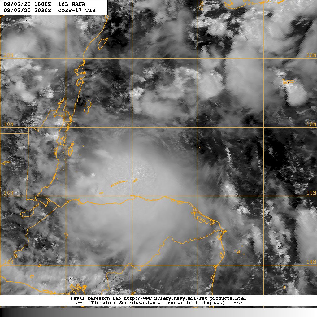
400 PM CDT Wed Sep 02 2020

Nana continues to feel the effects of about 15 kt of northerly
vertical shear, as the low-level center is located near the
northern edge of the main convective mass.  Data from the last Air
Force Reserve Hurricane Hunter Mission showed that the flight-level
winds at 850 mb were a little lower than earlier.  However,
incomplete SFMR data suggested surface winds near 50 kt, and the
aircraft reported that the central pressure is near 999 mb.  The
initial intensity is held at 50 kt, although this could be a little
generous.

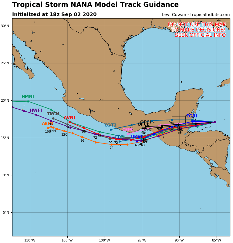
The initial motion is westward or 270/13 kt.  A low- to mid-level
ridge to the north of the cyclone is forecast to keep steering Nana
toward the west, or maybe just south of west, for the remainder of
the cyclone's life.  The new forecast track, which again is changed
only slightly from the previous forecast, calls for the cyclone to
pass north of the Bay Islands this evening, then make landfall over
central or southern Belize in about 12-18 h.  

Nana is running out of time to strengthen before landfall, and
between that and the ongoing shear none of the intensity guidance
forecasts it to become a hurricane before landfall.  However, any
strong convective burst could spin up the cyclone, and since the
bursts have been frequent today the intensity forecast calls for
Nana to strengthen to near hurricane strength at landfall.  After
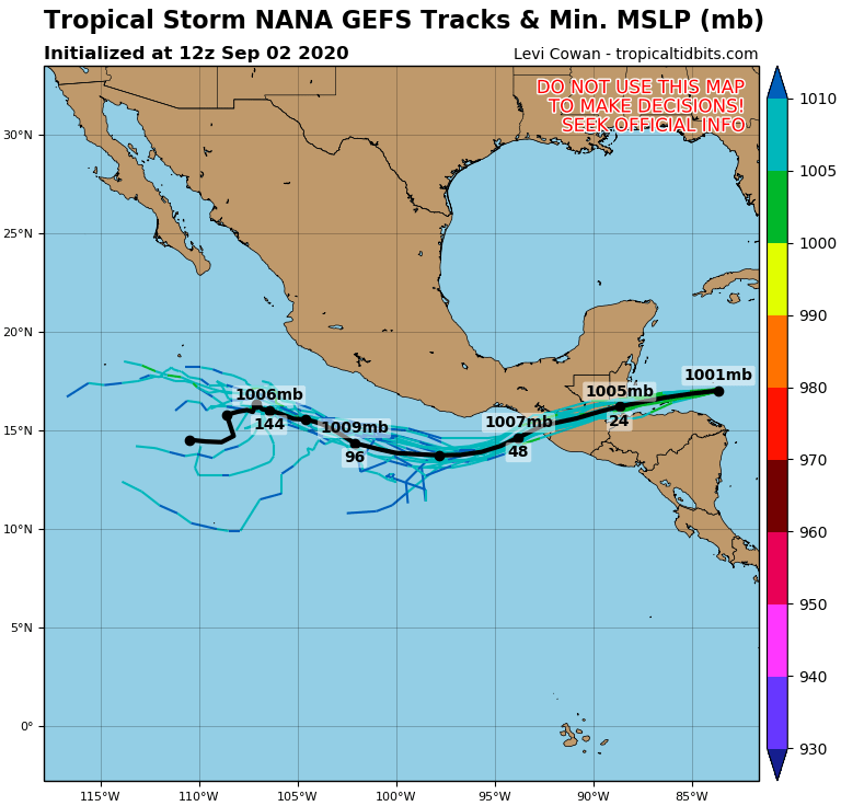
landfall, steady weakening is expected.  Several of the global
models now show the remnants of Nana emerging over the Gulf of
Tehuantepec in 48-60 h.  However, these models continue to forecast
dissipation even over water, so the forecast dissipation time is
unchanged since the previous advisory.


KEY MESSAGES:

1. Nana could bring hurricane conditions and dangerous storm surge
tonight to portions of the coast of Belize, and a hurricane warning
is in effect. Preparations to protect life and property should be
rushed to completion.

2. Tropical storm conditions are expected in the tropical storm
warning areas in Belize, the Bay Islands, Guatemala, and the
Yucatan Peninsula of Mexico by tonight.

3. Heavy rainfall with isolated maximum amounts as high as 8 to 12
inches could result in flash flooding in Belize, Guatemala, and
portions of southeastern Mexico and the Yucatan Peninsula.


FORECAST POSITIONS AND MAX WINDS

INIT  02/2100Z 17.0N  85.9W   50 KT  60 MPH
12H  03/0600Z 16.8N  87.8W   60 KT  70 MPH
24H  03/1800Z 16.6N  90.1W   45 KT  50 MPH...INLAND
36H  04/0600Z 16.4N  92.4W   30 KT  35 MPH...INLAND
48H  04/1800Z 16.2N  94.8W   20 KT  25 MPH...POST-TROP/REMNT LOW
60H  05/0600Z...DISSIPATED

$$
Forecaster Beven
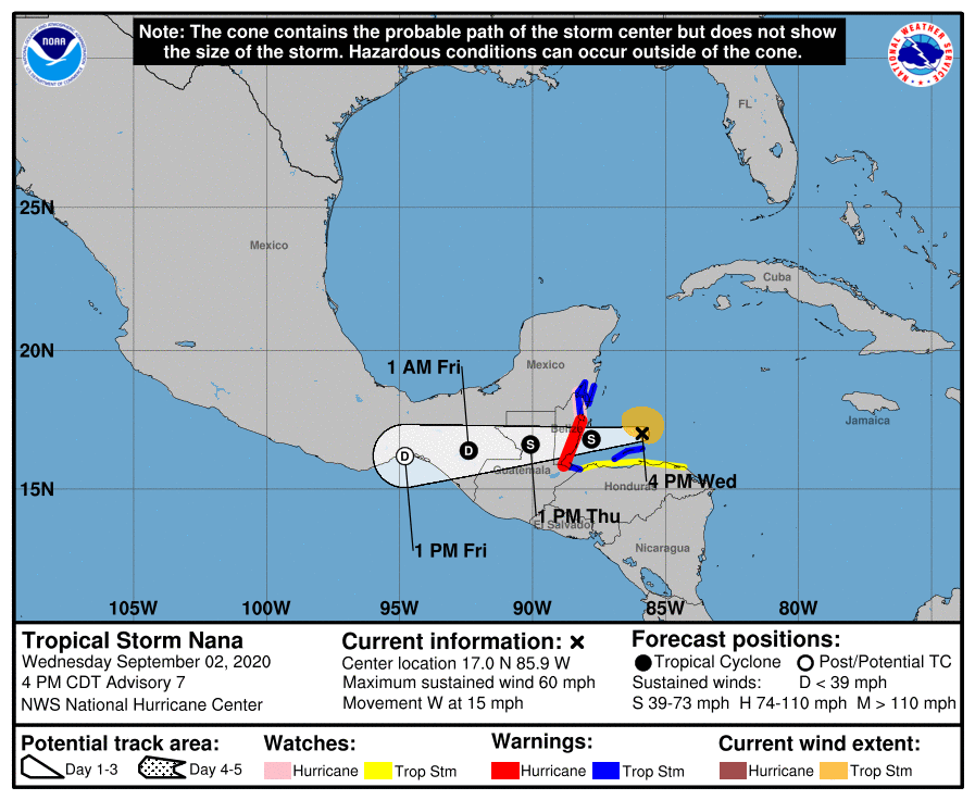
AL162020_5day_cone_no_line_and_wind.png 20200902.2030.goes17.x.vis1km_high.16LNANA.50kts-999mb-171N-852W.100pc.jpg
16L_tracks_latest (1).png 16L_gefs_latest.png


回復

使用道具 舉報

簽到天數: 601 天

[LV.9]以壇為家II

霧峰追風者|2020-9-3 08:31 | 顯示全部樓層
NHC 展望提升10%。
1. The remnants of Atlantic basin Tropical Storm Nana could emerge
over the eastern Pacific waters near the Gulf of Tehuantepec on
Friday. Unfavorable upper-level winds are expected to limit
development through the weekend while the system moves generally
west-northwestward near the southern coast of Mexico.
* Formation chance through 48 hours...low...10 percent.
* Formation chance through 5 days...low...20 percent.
two_pac_2d1.png

點評

進太平洋重新發展?  發表於 2020-9-3 12:45
回復

使用道具 舉報

簽到天數: 53 天

[LV.5]常住居民I

天篷大元帥|2020-9-3 12:53 | 顯示全部樓層
國家颶風中心:颶風
颶風警告在貝里斯海岸生效
原文:
000
WTNT41 KNHC 030252
TCDAT1

Hurricane Nana Discussion Number   8
NWS National Hurricane Center Miami FL       AL162020
1000 PM CDT Wed Sep 02 2020

After the center of Nana nearly became exposed during the late
afternoon, a new burst of convection developed near and to the
south of the center which has resulted in strengthening this
evening.  Very recently received data from an Air Force Reserve
reconnaissance aircraft has indicated that Nana has become a
hurricane.  The plane has measured a peak 700-mb flight-level
wind of 72 kt to the north of the center, and peak SFMR winds
of 62 kt earlier this evening.  These data support an initial
intensity of 65 kt, making Nana the fifth hurricane of the 2020
Atlantic basin hurricane season.  Since Nana should make landfall
along the coast of Belize within the next several hours, little
additional strengthening is expected before the center crosses the
coast.  Rapid weakening will occur after landfall, and the new 12
through 36 hour intensity forecast reflects this.  The low-level
center is likely to dissipate over mountainous terrain within 48
hours, if not sooner.

Nana is moving just south of due west at about 265/14 kt. A low- to
mid-level ridge to the north of Nana should keep it moving on a
west-southwestward motion during the next day or so.  The guidance
enveloped has shifted slightly southward and the new NHC track
forecast has been adjusted accordingly.

KEY MESSAGES:

1. Hurricane conditions and a dangerous storm surge will spread
onshore along portions of the coast of Belize within the Hurricane
Warning area through early Thursday.

2. Tropical storm conditions are expected in the tropical storm
warning areas in Belize, the Bay Islands, Guatemala, and the
Yucatan Peninsula of Mexico through early Thursday.

3. Heavy rainfall with isolated maximum amounts as high as 8 to 12
inches could result in flash flooding in Belize, Guatemala, and
portions of southeastern Mexico and the Yucatan Peninsula.


FORECAST POSITIONS AND MAX WINDS

INIT  03/0300Z 17.0N  87.5W   65 KT  75 MPH
12H  03/1200Z 16.8N  89.2W   50 KT  60 MPH...INLAND
24H  04/0000Z 16.4N  91.6W   30 KT  35 MPH...INLAND
36H  04/1200Z 16.0N  93.9W   20 KT  25 MPH...POST-TROP/REMNT LOW
48H  05/0000Z...DISSIPATED

$$
Forecaster Brown
粗劣的機器翻譯:
000
WTNT41 KNHC 030252
TCDAT1

颶風娜娜討論號8
NWS國家颶風中心邁阿密FL AL162020
1000 PM CDT星期三2020年9月2
日下午晚些時候,

娜娜的中心幾乎暴露在外後,
南對流爆發了新的對流中心,今天
晚上得到了加強。最近從空軍預備隊
偵察機獲得的數據表明,娜娜已成為
颶風。這架飛機
在中心以北測得700 mb峰值的飛行高度為700 海裡,而今晚
早些時候的SFMR峰值為62 kt。這些數據支持初始
強度達65 kt,使娜娜成為2020年
大西洋盆地颶風季節的第五次颶風。由于娜娜將
在接下來的幾個小時內沿伯利茲海岸登陸,因此
在該中心越過
海岸之前,預計幾乎沒有其他的加強措施。登陸後將迅速減弱,新的12
至36小時強度預報反映了這一點。低層
中心很可能會在48
小時內消散在山區地形上,即使不是更早。

娜娜(Nana)以大約265/14 kt的速度向正西移動。
娜娜(Nana)北部的中低階山脊
在第二天左右應使其向西南偏西運動。指引
包圍狀態已稍微向南移動,新的NHC跟踪
預報也作了相應調整。

關鍵信息:

1.颶風狀況和危險的風暴潮將
在颶風
預警區域內的伯利茲海岸部分地區陸續蔓延至週四初。

2.
到星期四初
,預計在伯利茲,海灣群島,危地馬拉和墨西哥尤卡坦半島的熱帶風暴預警地區將出現熱帶風暴情況。

3.個別最大降雨量高達8至12
英寸的強降雨可能在伯利茲,危地馬拉以及
墨西哥東南部和尤卡坦半島的部分地區造成山洪氾濫。


預測位置和最大風

INIT 03 / 0300Z 17.0N 87.5W 65 KT 75 MPH
12H 03 / 1200Z 16.8N 89.2W 50 KT 60 MPH ...
內陸24H 04 / 0000Z 16.4N 91.6W 30 KT 35 MPH ...
內陸36H 04 / 1200Z 16.0N 93.9W 20 KT 25 MPH ...後撤/後撤低
48H 05 / 0000Z ...已分發

$$
Forecaster Brown

颶風警告.png
回復

使用道具 舉報

12下一頁
快速回覆
您需要登錄後才可以回帖 登錄 | 立即加入

本版積分規則

本平台僅供學術討論之用,預報應以氣象局為準

威普網站虛擬主機贊助公司

臺灣第一個天氣類型社群平台 即時天氣資訊、精準颱風動態

線上客服
FB傳送訊息
廣告行銷
精準行銷 物超所值
官方粉專
發佈 快速回復 返回頂部 返回列表