開啟輔助訪問
 找回密碼
 立即加入

18L.Rene 風場較小 發展不如預期

簽到天數: 1650 天

[LV.Master]伴壇終老

2020-9-6 21:05 來自手機 | 顯示全部樓層
  熱帶風暴  
編號:18 L  
名稱:Rene
045555dyewnyknlnxxjey6.jpg

  基本資料  
擾動編號日期:2020 09 06 20
命名日期  :2020 09 08 05
撤編日期  :2020 09 00 00
登陸地點  :

  巔峰時期資料  
近中心最強風速 :40  kt ( TS )
海平面最低氣壓 :1001 百帕

  擾動編號資料  

93L.INVEST.25kts-1008mb-145N-183W
20200906.1230.goes16.x.vis1km_high.93LINVEST.25kts-1008mb-145N-183W.100pc.jpg


  NHC:50%
2. Showers and thunderstorms are showing signs of organization in
association with a tropical wave that is located just off the coast
of western Africa. Gradual development of this system is expected,
and a tropical depression is likely to form by the middle of the
week while it moves generally westward over the far eastern
tropical Atlantic. Interests in the Cabo Verde Islands should
monitor the progress of this system as gusty winds and locally
heavy rainfall is possible there on Monday and Tuesday.
* Formation chance through 48 hours...medium...50 percent.
* Formation chance through 5 days...high...80 percent.


two_atl_2d2.png two_atl_5d2.png
以上資料來自:NHC、颱風論壇整理製作

評分

參與人數 1水氣能量 +15 +1 收起 理由
t02436 + 15 + 1

查看全部評分

回復

使用道具 舉報

簽到天數: 1650 天

[LV.Master]伴壇終老

老農民版夜神月|2020-9-7 02:10 | 顯示全部樓層
NHC展望提升至70%/90%
2. Showers and thunderstorms are showing signs of organization in
association with a broad area of low pressure located just
off the coast of western Africa. Environmental conditions
are conducive for development, and a tropical depression is
expected to form within the next couple of days while it moves
generally westward over the far eastern tropical Atlantic. Interests
in the Cabo Verde Islands should monitor the progress of this system
as gusty winds and locally heavy rainfall is likely there Monday
night and Tuesday.
* Formation chance through 48 hours...high...70 percent.
* Formation chance through 5 days...high...90 percent.
two_atl_2d2.png two_atl_5d2.png
gfs_mslp_pcpn_93L_19.png
回復

使用道具 舉報

簽到天數: 1650 天

[LV.Master]伴壇終老

老農民版夜神月|2020-9-7 11:52 | 顯示全部樓層
FWC-N發布TCFA
SUBJ/TROPICAL CYCLONE FORMATION ALERT//
WTNT22 KNGU 062100
REF/A/FLEWEACEN NORFOLK VA/061300Z SEP 06//
AMPN/REF IS TROPICAL CYCLONE FORMATION ALERT (WTNT21 KNGU 061300)//
RMKS/1. FORMATION OF A SIGNIFICANT TROPICAL CYCLONE IS POSSIBLE WITHIN
100 NM EITHER SIDE OF A LINE FROM 12.82N 18.3W TO 16.0N 18.3W
WITHIN THE NEXT 24 HOURS. AVAILABLE DATA DOES NOT JUSTIFY
ISSUANCE OF NUMBERED TROPICAL CYCLONE WARNINGS AT THIS TIME.
WINDS IN THE AREA ARE ESTIMATED TO BE 25 KNOTS. METSAT
IMAGERY AT 061800Z INDICATES THAT A CIRCULATION CENTER IS LOCATED
NEAR 14.5N 18.4W. THE SYSTEM IS MOVING WESTWARD AT 15 KNOTS.
2.SHOWERS AND THUNDERSTORMS PRODUCED BY A BROAD AREA OF LOW PRESSURE
LOCATED JUST OFF OF THE WEST AFRICA COAST ARE GRADUALLY BECOMING BETTER
ORGANIZED. ENVIRONMENTAL CONDITIONS ARE CONDUCIVE FOR FURTHER DEVELOPMENT
AND A TROPICAL DEPRESSION IS FORECAST TO FORM DURING THE NEXT 24 HOURS AS THE
SYSTEM MOVES WESTWARD AT 8 TO 12 KT OVER THE EASTERN TROPICAL ATLANTIC.
3. THIS ALERT WILL BE REISSUED, UPGRADED TO WARNING OR CANCELLED BY 072100Z.
4. SEE REF A FOR DETAILS ON A TROPICAL CYCLONE FORMATION ALERT
LOCATED NEAR 16.7N 40.6W//
al932020.gif goes16_vis-swir_93L_202009070115.gif
goes16_ir_93L_202009070115.gif

評分

參與人數 1水氣能量 +15 收起 理由
king111807 + 15 TCFA

查看全部評分

回復

使用道具 舉報

簽到天數: 1650 天

[LV.Master]伴壇終老

老農民版夜神月|2020-9-7 16:51 | 顯示全部樓層
NHC09Z升格18L,初報上望70KT不封頂
000
WTNT43 KNHC 070845
TCDAT3


Tropical Depression Eighteen Discussion Number   1

NWS National Hurricane Center Miami FL       AL182020

800 AM CVT Mon Sep 07 2020


Shower and thunderstorm activity associated with the area of low

pressure over the far eastern Atlantic has continued to increase and

become organized in a band overnight.  First light visible satellite

imagery suggests that the circulation has also become better

defined.  Based on the above, advisories are being initiated on a

new tropical depression, the eighteenth of the 2020 Atlantic

hurricane season.  Dvorak satellite estimates from both TAFB and SAB

support an intensity of 25 kt, but given the continued improvement

in organization the initial winds are set at 30 kt for this

advisory.  ASCAT data later this morning should provide additional

information on the intensity of the cyclone.  


The depression lies within a favorable upper-level environment and

the SHIPS guidance indicates that the vertical wind shear will

remain 10 kt or less over the next few days while the depression

traverses sea surface temperatures of around 27 degrees Celsius.   

These conditions, along with a moist mid-level atmosphere should

allow for steady strengthening over the next few days, and the NHC

forecast calls for the system to become a tropical storm later

today, and a hurricane in about 72 hours.  After that time, the

cyclone is forecast to pass over slightly cooler waters and the

global models depict an increase in southwesterly upper-level flow

over the system by the end of the period.  These less conducive

factors are expected to slow the intensification process toward the

end of the period. The NHC intensity forecast is a blend of the

IVCN multi-model consensus and the HFIP corrected consensus.


The initial motion of the depression is a somewhat uncertain

280/10 kt.  A narrow mid-level ridge to the north of the depression

is forecast to build westward over the next few days which is

expected to steer the system westward to west-northwestward, and

the track guidance is in good agreement through 72 hours.  After

that time, a weakness is forecast to develop in the ridge near 40

degrees west, and the cyclone is expected to turn

west-northwestward and then northwestward between the ridge to its

northeast and Tropical Depression Seventeen to its southwest.  Since

there could be some binary interaction between the two tropical

cyclones later in the period, the longer range track guidance is

not in as good of agreement, and there is more uncertainty than

average in the long-range track forecast.


Key Messages:


1.  The depression is forecast to strengthen into a tropical storm

later today and tropical storm conditions are expected to spread

over portions of the Cabo Verde Islands later today and tonight.  A

Tropical Storm Warning is in effect for those islands.


2.  The depression is expected to bring locally heavy rainfall to

portions of the Cabo Verde Islands through Tuesday morning.


FORECAST POSITIONS AND MAX WINDS


INIT  07/0900Z 15.2N  20.3W   30 KT  35 MPH

12H  07/1800Z 15.6N  22.0W   35 KT  40 MPH

24H  08/0600Z 16.0N  24.5W   40 KT  45 MPH

36H  08/1800Z 16.4N  27.3W   50 KT  60 MPH

48H  09/0600Z 16.8N  30.2W   55 KT  65 MPH

60H  09/1800Z 17.4N  32.9W   60 KT  70 MPH

72H  10/0600Z 18.1N  35.5W   65 KT  75 MPH

96H  11/0600Z 19.7N  39.6W   70 KT  80 MPH

120H  12/0600Z 22.4N  43.2W   70 KT  80 MPH


$$

Forecaster Brown

084729_5day_cone_with_line_and_wind.png goes16_vis-swir_93L_202009070545.gif
goes16_ir_93L_202009070545.gif

回復

使用道具 舉報

簽到天數: 1650 天

[LV.Master]伴壇終老

老農民版夜神月|2020-9-8 03:33 | 顯示全部樓層
NHC認為18L18Z強度已達TS,定強35KT,若無意外稍晚21Z報即將命名
Tropical Storm EIGHTEEN
As of 18:00 UTC Sep 07, 2020:

Location: 15.9°N 21.7°W
Maximum Winds: 35 kt
Minimum Central Pressure: 1001 mb
Environmental Pressure: 1006 mb
Radius of Circulation: 180 nm
Radius of Maximum wind: 40 nm

goes16_ir_18L_202009071645.gif goes16_vis_18L_202009071645.gif
gfs_mslp_pcpn_18L_15.png
回復

使用道具 舉報

簽到天數: 1650 天

[LV.Master]伴壇終老

老農民版夜神月|2020-9-8 04:56 | 顯示全部樓層
NHC21Z正式升格TS,命名Rene
662
WTNT43 KNHC 072034
TCDAT3

Tropical Storm Rene Discussion Number   3
NWS National Hurricane Center Miami FL       AL182020
800 PM CVT Mon Sep 07 2020

The cyclone is getting better organized on its approach to the Cabo
Verde Islands. Banding features are now well established over the
western part of the circulation, and some smaller bands are filling
in east of the center.  The satellite intensity estimates currently
range from 30 to 35 kt. Based on this data and the improved
satellite appearance of the system, the initial intensity is raised
to 35 kt, making the cyclone Tropical Storm Rene.  Rene is the 17th
named storm of the 2020 Atlantic hurricane season. It is also the
earliest 17th named storm of any Atlantic season by 11 days. The
previous record was Rita, which formed on September 18, 2005.

Rene is moving west-northwestward at 10 kt, and it should continue
moving in that direction with some increase in forward speed for at
least the next few days while subtropical ridging builds westward to
the north of the storm.  Toward the end of the forecast period, a
turn to the northwest is expected as Rene moves into a weakness in
the ridge. The models have shifted eastward at the longer ranges,
especially the ECMWF model, and the NHC forecast has been adjusted
in that direction at days 3 through 5.

Rene is forecast to gradually strengthen during the next few days as
the storm is expected to remain over relatively warm water while
moving through an environment consisting of low vertical wind shear
and high amounts of moisture.  An increase in southwesterly shear
late this week and this weekend should end the strengthening trend
and induce some weakening.  The NHC intensity forecast is again an
update of the previous one, and is now in line with the HCCA and
IVCN consensus models.

Key Messages:

1. Rene is expected to produce tropical storm conditions across
portions of the Cabo Verde Islands tonight and early Tuesday.  A
Tropical Storm Warning is in effect for those islands.

2. Rene will bring locally heavy rainfall to portions of the Cabo
Verde Islands through Tuesday morning.


FORECAST POSITIONS AND MAX WINDS

INIT  07/2100Z 16.1N  22.3W   35 KT  40 MPH
12H  08/0600Z 16.3N  24.1W   40 KT  45 MPH
24H  08/1800Z 16.7N  26.8W   50 KT  60 MPH
36H  09/0600Z 17.2N  29.6W   55 KT  65 MPH
48H  09/1800Z 17.8N  32.3W   60 KT  70 MPH
60H  10/0600Z 18.6N  35.0W   65 KT  75 MPH
72H  10/1800Z 19.6N  37.4W   70 KT  80 MPH
96H  11/1800Z 22.1N  41.3W   70 KT  80 MPH
120H  12/1800Z 26.0N  44.0W   65 KT  75 MPH

$$
Forecaster Cangialosi

203625_5day_cone_with_line_and_wind.png 20200907.2020.goes-16.ir.18L.EIGHTEEN.35kts.1001mb.15.9N.21.7W.100pc.jpg
20200907.1810.gpm.89hbt.18L.EIGHTEEN.35kts.1001mb.15.9N.21.7W.045pc.jpg 20200907.1810.gpm.89pct89h89v.18L.EIGHTEEN.35kts.1001mb.15.9N.21.7W.045pc.jpg
回復

使用道具 舉報

簽到天數: 1650 天

[LV.Master]伴壇終老

老農民版夜神月|2020-9-9 11:00 | 顯示全部樓層
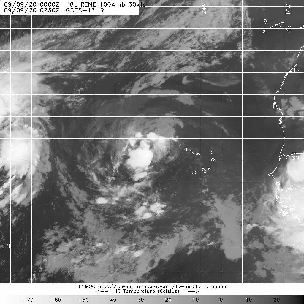
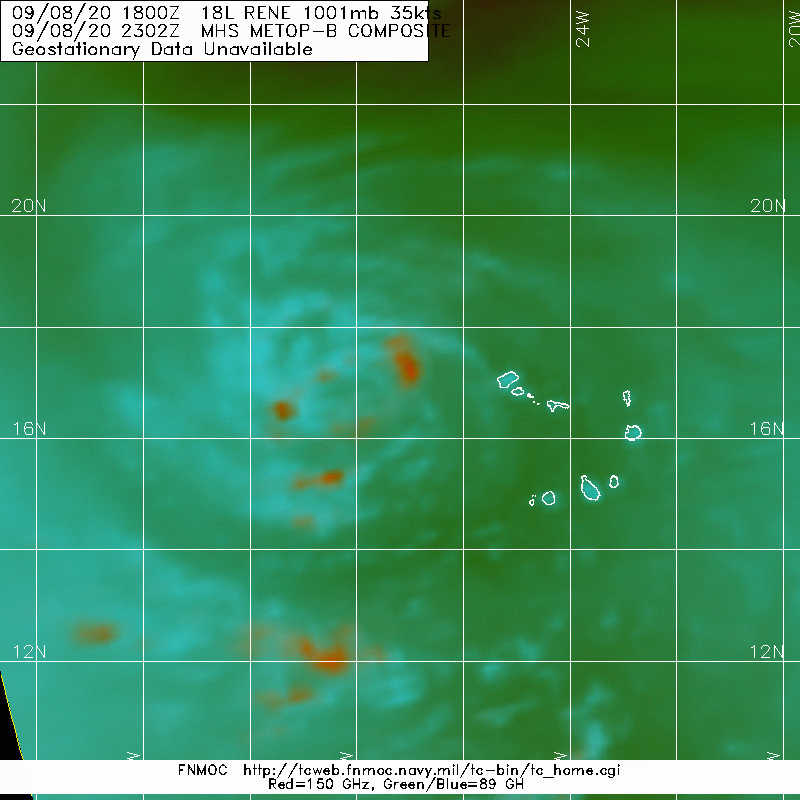
暫時減弱為TD,但NHC仍舊看好Rene60H後將短暫成為颶風
384
WTNT43 KNHC 090251
TCDAT3

Tropical Depression Rene Discussion Number   8
NWS National Hurricane Center Miami FL       AL182020
200 AM CVT Wed Sep 09 2020

Rene's circulation remains fairly robust based on a 08/2148Z ASCAT-A
overpass. However, the overall convective pattern has eroded
significantly, and this is reflected in the ASCAT scatterometer wind
data only showing surface winds of about 25 kt. Allowing for some
undersampling, plus a recent increase in convection near the
center, the intensity has only been lowered to 30 kt for this
advisory. Rene remains beneath a pronounced upper-level anticyclone
and outflow is fairly symmetrical in all quadrants.

The initial motion is 285/14 kt. There continues to be no
significant change to previous forecast track or reasoning. Rene is
expected to move generally west-northwestward around the
southwestern periphery of a deep-layer ridge for the next couple of
days, followed by a decrease in forward speed and a turn toward the
northwest on Friday and a motion toward the north on Saturday and
Sunday. The latest NHC model guidance is in decent agreement on
this developing steering flow pattern, thus the new NHC track
forecast is essentially just an extension of the previous advisory
track and lies close to a blend of the consensus models TVCA, GFEX,
and NOAA-HCCA.

Although Rene has weakened, a burst of strong convection with cloud
tops colder than -80C has developed over and to the west of the
center, while a fragmented band of convection has formed in the
northern semicircle. These features strongly suggest that Rene is
poised to restrengthen soon. Sea-surface temperatures are expected
to be 26.0-26.5 deg C in the 24-60 h period, which are only marginal
for strengthening to occur. However, mid-level humidity values are
forecast to be near 70 percent and the cyclone is expected to remain
under a favorable upper-level anticyclone during that time.  Given
these factors, slow but steady intensification is forecast, with
Rene still expected to become a hurricane in 2-3 days.  Thereafter,
strong westerly to west-northwesterly vertical wind shear in excess
of 25-30 kt is expected to cause Rene to weaken significantly on
days 4 and 5. The new official intensity forecast is similar to but
slightly lower than the previous intensity forecast, and is along
the extreme upper portion of the guidance envelope and is above the
intensity consensus models.


FORECAST POSITIONS AND MAX WINDS

INIT  09/0300Z 17.0N  29.3W   30 KT  35 MPH
12H  09/1200Z 17.5N  31.1W   35 KT  40 MPH
24H  10/0000Z 18.4N  33.7W   40 KT  45 MPH
36H  10/1200Z 19.3N  35.9W   50 KT  60 MPH
48H  11/0000Z 20.5N  38.1W   60 KT  70 MPH
60H  11/1200Z 22.1N  39.8W   65 KT  75 MPH
72H  12/0000Z 24.2N  41.4W   60 KT  70 MPH
96H  13/0000Z 28.5N  42.6W   50 KT  60 MPH
120H  14/0000Z 30.2N  40.3W   40 KT  45 MPH

$$
Forecaster Stewart
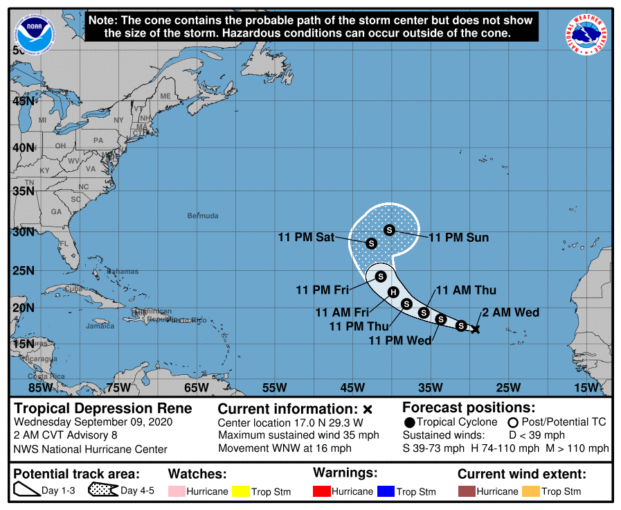
025251_5day_cone_no_line_and_wind.png sm20200909.0230.goes-16.ir.18L.RENE.30kts.1004mb.16.8N.28.6W.100pc.jpg

20200908.2302.metopb.89rgb.18L.RENE.35kts.1001mb.16.7N.27.2W.100pc.jpg


回復

使用道具 舉報

簽到天數: 1650 天

[LV.Master]伴壇終老

老農民版夜神月|2020-9-11 16:53 | 顯示全部樓層
發展不如預期,NHC新報不再上望颶風
ZCZC MIATCDAT3 ALL
TTAA00 KNHC DDHHMM

Tropical Storm Rene Discussion Number  17
NWS National Hurricane Center Miami FL       AL182020
500 AM AST Fri Sep 11 2020

An AMSR2-GM1 microwave pass revealed that Rene's surface center is
farther separated from the shrinking deep convection.  The 0000 UTC
FV3 and ECMWF model soundings indicate that east-southeasterly
30-35 kt shear near 300 mb is temporarily undercutting the
diffluent southerly flow aloft.  The initial intensity is held at
40 kt and is based on the subjective Dvorak estimates from TAFB and
SAB, and an ADT estimates yielding 39 kt.

The shear is expected to relax during the next 36 to 48 hours which
should allow for gradual intensification.  By mid-period, Rene is
forecast to move into an area of increasing west-northwesterly
shear, which should induce a weakening trend.  It's worth noting
that the ECMWF and the FV3 Decay SHIPS show very little
strengthening through the period and it appears to be due to
the cyclone moving into an even more inhibiting thermodynamic
environment, in addition to the aforementioned shear.  In fact, the
relative humidity in the mid portions of the atmospheric is less
than 49 percent beyond day 3.  The NHC forecast sides with the
various intensity consensus models and is above the
statistical-dynamical guidance.

Rene continues to move west-northwestward, or 290/9 kt within the
southwestern periphery of a mid-tropospheric ridge extending
from western Africa to the eastern Atlantic.  A turn toward the
northwest on Saturday, followed by a north-northwestward and
northward motion with a decrease in forward speed is forecast
Sunday and Sunday night.  Early next week, a subtropical ridge is
forecast to build to the northwest of Rene, in response to Tropical
Storm Paulette moving northeastward over the northern central
Atlantic.  This change in the steering pattern should cause the
cyclone to begin a southwestward to west-southwestward drift
through the end of the period.  The official track forecast is
close to the previous advisory through day 4, then it's nudged a
little south to conform with the HCCA and TVCA multi-model aids.

FORECAST POSITIONS AND MAX WINDS

INIT  11/0900Z 19.7N  38.5W   40 KT  45 MPH
12H  11/1800Z 20.4N  40.2W   45 KT  50 MPH
24H  12/0600Z 21.6N  42.4W   50 KT  60 MPH
36H  12/1800Z 23.2N  44.3W   60 KT  70 MPH
48H  13/0600Z 25.0N  45.6W   60 KT  70 MPH
60H  13/1800Z 26.6N  46.1W   55 KT  65 MPH
72H  14/0600Z 27.4N  46.0W   50 KT  60 MPH
96H  15/0600Z 26.9N  46.4W   40 KT  45 MPH
120H  16/0600Z 26.1N  48.8W   35 KT  40 MPH

$$
Forecaster Roberts

NNNN
084427_5day_cone_with_line_and_wind.png 20200911.0820.goes-16.ir.18L.RENE.40kts.1002mb.19.5N.38W.100pc.jpg
18L_gefs_latest.png
回復

使用道具 舉報

12下一頁
快速回覆
您需要登錄後才可以回帖 登錄 | 立即加入

本版積分規則

本平台僅供學術討論之用,預報應以氣象局為準

威普網站虛擬主機贊助公司

臺灣第一個天氣類型社群平台 即時天氣資訊、精準颱風動態

線上客服
FB傳送訊息
廣告行銷
精準行銷 物超所值
官方粉專
發佈 快速回復 返回頂部 返回列表